Western Rio Arriba, New Mexico
Submit your own pictures of this place and show them to the world
- OSM Map
- General Map
- Google Map
- MSN Map

| Males: 135 | |
| Females: 132 |
| Median resident age: | 41.3 years |
| New Mexico median age: | 34.6 years |
Zip code: 87412
| Western Rio Arriba: | $26,109 |
| NM: | $59,726 |
Estimated per capita income in 2022: $16,991 (it was $8,373 in 2000)
Western Rio Arriba CCD income, earnings, and wages data
Estimated median house or condo value in 2022: $128,609 (it was $47,600 in 2000)
| Western Rio Arriba: | $128,609 |
| NM: | $243,100 |
Western Rio Arriba, NM residents, houses, and apartments details
Detailed information about poverty and poor residents in Western Rio Arriba, NM
Compare current foreclosures near your location:
| Photo | Address | Area | Beds / Baths | Price | Details |
|---|---|---|---|---|---|

|
#1
S High St
Columbus, OH 43207
|
1,678 sq. feet
|
2 baths 4 beds |
$31,900
|
show details |

|
#2
Bayberry Cir
Columbus, OH 43207
|
1,564 sq. feet
|
1 baths 3 beds |
$127,500
|
show details |

|
#3
E 21st Ave
Columbus, OH 43211
|
1,061 sq. feet
|
1 baths 3 beds |
$179,900
|
show details |

|
#4
Sleeping Meadow Dr
New Albany, OH 43054
|
3,211 sq. feet
|
2 baths 4 beds |
show details | |

|
#5
Kelton Ave
Columbus, OH 43206
|
1,080 sq. feet
|
1 baths 3 beds |
show details | |

|
#6
Striebel Ct
Columbus, OH 43227
|
925 sq. feet
|
1 baths 3 beds |
show details | |

|
#7
Grasmere Ave
Columbus, OH 43211
|
720 sq. feet
|
1 baths 2 beds |
show details | |

|
#8
Marshrun Dr
Grove City, OH 43123
|
2,036 sq. feet
|
2 baths 4 beds |
show details | |

|
#9
Stoneybrook Blvd # 21a
Hilliard, OH 43026
|
1,231 sq. feet
|
2 baths 3 beds |
show details | |

|
#10
High Free Pike
West Jefferson, OH 43162
|
1,216 sq. feet
|
2 baths 4 beds |
show details |
| Photo | Address | Area | Beds / Baths | Price | Details |
|---|---|---|---|---|---|

|
#11
Lehner Rd
Columbus, OH 43224
|
1,628 sq. feet
|
2 baths 4 beds |
show details | |

|
#12
Brookstone Dr
Westerville, OH 43082
|
1,783 sq. feet
|
3 baths 3 beds |
show details | |

|
#13
S Hague Ave
Columbus, OH 43204
|
979 sq. feet
|
1 baths 2 beds |
show details | |

|
#14
Meadowbrook Dr
Columbus, OH 43207
|
1,752 sq. feet
|
2 baths 4 beds |
show details | |

|
#15
Hiawatha Park Dr
Columbus, OH 43211
|
1,278 sq. feet
|
1 baths 4 beds |
show details | |

|
#16
N Roys Ave
Columbus, OH 43204
|
1,248 sq. feet
|
2 baths 3 beds |
show details | |

|
#17
S Richardson Ave
Columbus, OH 43204
|
1,520 sq. feet
|
2 baths 3 beds |
show details | |

|
#18
E Howard Rd
Columbus, OH 43207
|
1,056 sq. feet
|
1 baths 3 beds |
show details | |

|
#19
Summertree Ln
Westerville, OH 43081
|
2,496 sq. feet
|
2 baths 3 beds |
show details | |

|
#20
Fergus Rd
Grove City, OH 43123
|
3,312 sq. feet
|
2 baths 4 beds |
show details |
| Photo | Address | Area | Beds / Baths | Price | Details |
|---|---|---|---|---|---|

|
#21
Hildreth Ave
Columbus, OH 43203
|
1,798 sq. feet
|
2 baths 4 beds |
show details | |

|
#22
Armada Rd
Columbus, OH 43232
|
1,028 sq. feet
|
1 baths 4 beds |
show details | |

|
#23
N 18th St
Columbus, OH 43203
|
1,690 sq. feet
|
1 baths 4 beds |
show details | |

|
#24
Chester Rd
Columbus, OH 43221
|
3,300 sq. feet
|
4 baths 5 beds |
show details | |

|
#25
Glenmate Ct
Columbus, OH 43223
|
1,050 sq. feet
|
1 baths 3 beds |
show details | |

|
#26
Bernadette Rd
Columbus, OH 43204
|
1,168 sq. feet
|
1 baths 3 beds |
show details | |

|
#27
Chidley St
Galloway, OH 43119
|
1,502 sq. feet
|
1 baths 3 beds |
show details | |

|
#28
Gladys Rd
Columbus, OH 43228
|
832 sq. feet
|
1 baths 3 beds |
show details | |

|
#29
Ashgrove Dr
Grove City, OH 43123
|
1,772 sq. feet
|
2 baths 4 beds |
show details | |

|
#30
Midland Ave
Columbus, OH 43223
|
1,518 sq. feet
|
1 baths 2 beds |
show details |
| Photo | Address | Area | Beds / Baths | Price | Details |
|---|---|---|---|---|---|

|
#31
Kingsglen Dr
Grove City, OH 43123
|
1,635 sq. feet
|
2 baths 4 beds |
show details | |

|
#32
Fairfield Ave
Columbus, OH 43203
|
984 sq. feet
|
1 baths 2 beds |
show details | |

|
#33
Wrexham Ave
Columbus, OH 43223
|
1,235 sq. feet
|
1 baths 3 beds |
show details | |

|
#34
London Groveport Rd
Grove City, OH 43123
|
816 sq. feet
|
1 baths 2 beds |
show details | |

|
#35
E Welch Ave
Columbus, OH 43207
|
1,864 sq. feet
|
2 baths 4 beds |
show details | |

|
#36
Scottwood Rd
Columbus, OH 43227
|
1,008 sq. feet
|
1 baths 3 beds |
show details | |

|
#37
Mink St SW
Pataskala, OH 43062
|
1,442 sq. feet
|
1 baths 3 beds |
show details | |

|
#38
Barthel Ave
Columbus, OH 43227
|
1,276 sq. feet
|
1 baths 3 beds |
show details | |

|
#39
Ridgebury Dr
Hilliard, OH 43026
|
832 sq. feet
|
1 baths 2 beds |
show details | |

|
#40
Pendent Ln
Columbus, OH 43207
|
1,260 sq. feet
|
2 baths 3 beds |
show details |
| Photo | Address | Area | Beds / Baths | Price | Details |
|---|---|---|---|---|---|

|
#41
Messner Dr
Hilliard, OH 43026
|
832 sq. feet
|
1 baths 2 beds |
show details | |

|
#42
Tea Party Pl
Columbus, OH 43207
|
1,176 sq. feet
|
2 baths 3 beds |
show details | |

|
#43
Camhurst Ct
Galloway, OH 43119
|
1,969 sq. feet
|
2 baths 3 beds |
show details | |

|
#44
Conway Dr
Columbus, OH 43227
|
1,232 sq. feet
|
1 baths 3 beds |
show details | |

|
#45
Illinois Ave
Westerville, OH 43081
|
1,120 sq. feet
|
1 baths 3 beds |
show details | |

|
#46
Mango Ln
Hilliard, OH 43026
|
1,024 sq. feet
|
1 baths 2 beds |
show details | |

|
#47
Renford Ct
Powell, OH 43065
|
1,795 sq. feet
|
1 baths 3 beds |
show details | |

|
#48
Windy Hill Ln
Galloway, OH 43119
|
1,108 sq. feet
|
2 baths 3 beds |
show details | |

|
#49
Windy Hill Ln
Galloway, OH 43119
|
1,350 sq. feet
|
2 baths 3 beds |
show details | |

|
Check over 1 million property listings on Foreclosure.com!
|
browse all offers | |||

- 15657.6%American Indian alone
- 8732.1%White alone
- 259.2%Hispanic
- 20.7%Other race alone
- 10.4%Two or more races

Races in Western Rio Arriba detailed stats: ancestries, foreign born residents, place of birth
 Recent articles from our blog. Our writers, many of them Ph.D. graduates or candidates, create easy-to-read articles on a wide variety of topics.

Current Local Time: MST time zone
Land area: 923.5 square miles.
Population density: 0.3 people per square mile (very low).

| Western Rio Arriba CCD: | 0.4% ($199) |
| New Mexico: | 0.7% ($699) |
Nearest city with pop. 50,000+: Rio Rancho, NM  (99.2 miles , pop. 51,765).
Nearest city with pop. 200,000+: Albuquerque, NM (111.6 miles , pop. 448,607).
Nearest city with pop. 1,000,000+: Phoenix, AZ (335.5 miles , pop. 1,321,045).
Nearest cities:
), ), ), Latitude: 36.57 N, Longitude: 107.46 W


| Here: | 3.3% |
| New Mexico: | 3.6% |

- Agriculture, forestry, fishing & hunting (19.7%)
- Health care (12.1%)
- Arts, entertainment, recreation (12.1%)
- Gasoline stations (7.6%)
- Public administration (7.6%)
- Machinery (6.1%)
- Mining, quarrying, oil & gas extraction (4.5%)

- Arts, entertainment, recreation (25.8%)
- Gasoline stations (16.1%)
- Machinery (12.9%)
- Petroleum & petroleum products merchant wholesalers (9.7%)
- Rail transportation (9.7%)
- Public administration (9.7%)
- Repair & maintenance (9.7%)

- Agriculture, forestry, fishing & hunting (37.1%)
- Health care (22.9%)
- Mining, quarrying, oil & gas extraction (8.6%)
- Building material & garden equipment & supplies dealers (8.6%)
- Department & other general merchandise stores (5.7%)
- Public administration (5.7%)
- U. S. Postal service (5.7%)

- Other protective service workers, including supervisors (12.1%)
- Farmers and farm managers (9.1%)
- Bookkeeping, accounting, and auditing clerks (9.1%)
- Health technologists and technicians (7.6%)
- Cashiers (7.6%)
- Other transportation occupations (7.6%)
- Building and grounds cleaning and maintenance occupations (6.1%)

- Other protective service workers, including supervisors (25.8%)
- Other transportation occupations (16.1%)
- Pipelayers, plumbers, pipefitters, and steamfitters (12.9%)
- Law enforcement workers, including supervisors (9.7%)
- Supervisors, construction and extraction workers (9.7%)
- Vehicle and mobile equipment mechanics, installers, and repairers (9.7%)
- Laborers and material movers, hand (9.7%)

- Farmers and farm managers (17.1%)
- Bookkeeping, accounting, and auditing clerks (17.1%)
- Health technologists and technicians (14.3%)
- Cashiers (14.3%)
- Agricultural workers, including supervisors (11.4%)
- Registered nurses (8.6%)
- Building and grounds cleaning and maintenance occupations (5.7%)
Average climate in Western Rio Arriba, New Mexico
Based on data reported by over 4,000 weather stations


(lower is better)

Air Quality Index (AQI) level in 2022 was 59.8. This is better than average.
| City: | 59.8 |
| U.S.: | 72.6 |

Nitrogen Dioxide (NO2) [ppb] level in 2022 was 6.17. This is worse than average. Closest monitor was 19.7 miles away from the city center.
| City: | 6.17 |
| U.S.: | 5.11 |

Ozone [ppb] level in 2022 was 37.0. This is about average. Closest monitor was 19.7 miles away from the city center.
| City: | 37.0 |
| U.S.: | 33.3 |

Particulate Matter (PM2.5) [µg/m3] level in 2013 was 3.14. This is significantly better than average. There were 0 monitors within city limits.
| City: | 3.14 |
| U.S.: | 8.11 |
Earthquake activity:
Western Rio Arriba-area historical earthquake activity is significantly above New Mexico state average. It is 1057% greater than the overall U.S. average.On 6/28/1992 at 11:57:34, a magnitude 7.6 (6.2 MB, 7.6 MS, 7.3 MW, Depth: 0.7 mi, Class: Major, Intensity: VIII - XII) earthquake occurred 537.4 miles away from Western Rio Arriba center, causing 3 deaths (1 shaking deaths, 2 other deaths) and 400 injuries, causing $100,000,000 total damage and $40,000,000 insured losses
On 10/16/1999 at 09:46:44, a magnitude 7.4 (6.3 MB, 7.4 MS, 7.2 MW, 7.3 ML) earthquake occurred 524.5 miles away from the city center
On 8/18/1959 at 06:37:13, a magnitude 7.7 (7.7 UK) earthquake occurred 577.9 miles away from Western Rio Arriba center, causing $26,000,000 total damage
On 8/23/2011 at 05:46:18, a magnitude 5.3 (5.3 MW, Depth: 2.5 mi, Class: Moderate, Intensity: VI - VII) earthquake occurred 156.5 miles away from the city center
On 5/19/1940 at 04:36:40, a magnitude 7.2 (7.2 UK) earthquake occurred 521.3 miles away from Western Rio Arriba center, causing $33,000,000 total damage
On 8/10/2005 at 22:08:22, a magnitude 5.0 (5.0 MW, Depth: 3.1 mi) earthquake occurred 147.8 miles away from the city center
Magnitude types: body-wave magnitude (MB), local magnitude (ML), surface-wave magnitude (MS), moment magnitude (MW)
Natural disasters:
The number of natural disasters in Rio Arriba County (13) is near the US average (15).Major Disasters (Presidential) Declared: 7
Emergencies Declared: 3
Causes of natural disasters: Floods: 5, Storms: 5, Fires: 4, Snows: 2, Drought: 1, Hurricane: 1, Mudslide: 1, Winter Storm: 1, Other: 1 (Note: some incidents may be assigned to more than one category).
Colleges/universities with over 2000 students nearest to Western Rio Arriba:
- San Juan College (about 42 miles; Farmington, NM; Full-time enrollment: 5,112)
- Fort Lewis College (about 54 miles; Durango, CO; FT enrollment: 3,631)
- Santa Fe Community College (about 107 miles; Santa Fe, NM; FT enrollment: 3,047)
- University of Phoenix-Albuquerque Campus (about 107 miles; Albuquerque, NM; FT enrollment: 2,335)
- Adams State University (about 108 miles; Alamosa, CO; FT enrollment: 2,805)
- University of New Mexico-Main Campus (about 114 miles; Albuquerque, NM; FT enrollment: 23,042)
- Central New Mexico Community College (about 114 miles; Albuquerque, NM; FT enrollment: 19,398)
Points of interest:
Notable locations in Western Rio Arriba: Lybrook Navajo Mission (A), Mauzy Trading Post (B), Mestice Ranch (C), Russell Arnold Ranch (D), Old Rock Ranch (E), San Juan Camp (F), Scissors Corral (G), Gomez (H), Vaqueros Cabin (I), Espinoza (J), Lowry Camp (K), Truby Ranch (L), Largo Camp (M), B C O Camp (N), Jicarilla Ranger Station (O), Espinosa Ranch (P), Gobernador Camp (Q), Gomez Ranch (R), Canyon View Ruin (S), Casa Mesa Diablo Historic Site (T). Display/hide their locations on the map
Cemetery: Carracas Cemetery (1). Display/hide its location on the map
Lakes and reservoirs: Albert Lake (A), Lost Lake (B), Lopez Lake (C), Candelaria Waterhole (D), Wild Horse Lake (E), Cuervo Lake (F), Laguna Seca (G), Deer Tank (H). Display/hide their locations on the map
Streams, rivers, and creeks: Cabresto Creek (A), Frances Creek (B), La Jara Creek (C), Muñoz Creek (D), Palluche Wash (E), Tapicito Creek (F), Sambrito Creek (G), Cañada Larga (H). Display/hide their locations on the map
Park in Western Rio Arriba: San Juan Basin Historical Marker (1). Display/hide its location on the map
| This place: | 2.4 people |
| New Mexico: | 2.6 people |
| This place: | 48.6% |
| Whole state: | 69.2% |
| This place: | 3.6% |
| Whole state: | 6.4% |
Likely homosexual households (counted as self-reported same-sex unmarried-partner households)
- Lesbian couples: 1.8% of all households
- Gay men: 0.0% of all households
| This place: | 52.3% |
| Whole state: | 18.4% |
| This place: | 32.3% |
| Whole state: | 7.8% |
For population 15 years and over in Western Rio Arriba:

- Never married: 23.4%
- Now married: 46.7%
- Separated: 4.1%
- Widowed: 11.7%
- Divorced: 18.3%
For population 25 years and over in Western Rio Arriba:
- High school or higher: 65.1%
- Bachelor's degree or higher: 5.7%
- Graduate or professional degree: 4.0%
- Unemployed: 12.0%
- Mean travel time to work (commute): 30.0 minutes


| Here: | 21.8 |
| New Mexico average: | 14.5 |
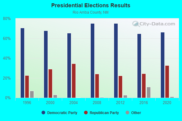
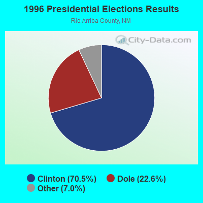
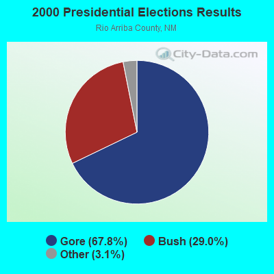
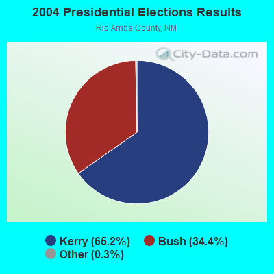
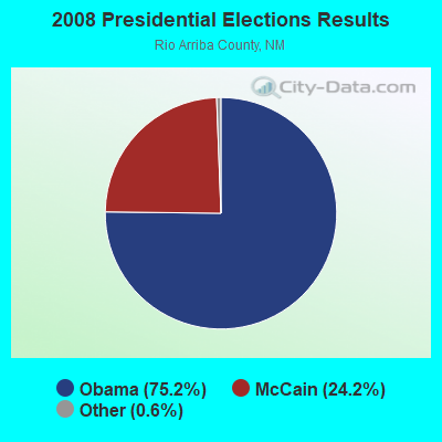
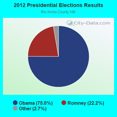
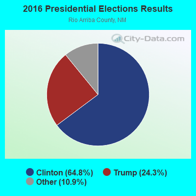
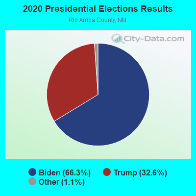
Graphs represent county-level data. Detailed 2008 Election Results
Religion statistics for Western Rio Arriba, NM (based on Rio Arriba County data)
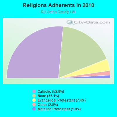
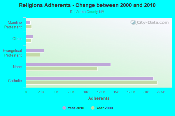
| Religion | Adherents | Congregations |
|---|---|---|
| Catholic | 21,305 | 41 |
| Evangelical Protestant | 2,960 | 29 |
| Other | 1,114 | 6 |
| Mainline Protestant | 722 | 9 |
| Orthodox | 5 | 1 |
| None | 14,140 | - |
Food Environment Statistics:
| Rio Arriba County: | 1.72 / 10,000 pop. |
| State: | 1.44 / 10,000 pop. |
| This county: | 0.25 / 10,000 pop. |
| State: | 0.21 / 10,000 pop. |
| This county: | 0.74 / 10,000 pop. |
| State: | 0.32 / 10,000 pop. |
| This county: | 5.16 / 10,000 pop. |
| New Mexico: | 4.06 / 10,000 pop. |
| Rio Arriba County: | 5.65 / 10,000 pop. |
| State: | 7.12 / 10,000 pop. |
| Rio Arriba County: | 5.9% |
| State: | 6.4% |
| Here: | 21.0% |
| New Mexico: | 22.1% |
Strongest AM radio stations in Western Rio Arriba:
- KTNN (660 AM; 50 kW; WINDOW ROCK, AZ; Owner: THE NAVAJO NATION)
- KKOB (770 AM; 50 kW; ALBUQUERQUE, NM; Owner: CITADEL BROADCASTING COMPANY)
- KENN (1390 AM; 10 kW; FARMINGTON, NM; Owner: WINTON ROAD BROADCASTING CO, LLC)
- KHAC (880 AM; 43 kW; TSE BONITO, NM; Owner: WESTERN INDIAN MINISTRIES, INC.)
- KNDN (960 AM; 5 kW; FARMINGTON, NM; Owner: BASIN BROADCASTING CO.)
- KRZE (1280 AM; 5 kW; FARMINGTON, NM; Owner: J. THOMAS DEVELOPMENT OF NM, INC.)
- KIUP (930 AM; 5 kW; DURANGO, CO; Owner: FOUR CORNERS BROADCASTING, LLC)
- KNZZ (1100 AM; 50 kW; GRAND JUNCTION, CO; Owner: M B C GRAND BROADCASTING, INC.)
- KLLV (550 AM; daytime; 2 kW; BREEN, CO; Owner: DAYSTAR RADIO, LTD.)
- KLTT (670 AM; 50 kW; COMMERCE CITY, CO; Owner: KLZ RADIO, INC.)
- KOA (850 AM; 50 kW; DENVER, CO; Owner: JACOR BROADCASTING OF COLORADO, INC.)
- KKIM (1000 AM; 10 kW; ALBUQUERQUE, NM; Owner: AGM-NEVADA, LLC)
- KKZN (760 AM; 50 kW; THORNTON, CO; Owner: JACOR BROADCASTING OF COLORADO, INC.)
Strongest FM radio stations in Western Rio Arriba:
- KKFG (104.5 FM; BLOOMFIELD, NM; Owner: CAPSTAR TX LIMITED PARTNERSHIP)
- KDAG (96.9 FM; FARMINGTON, NM; Owner: CAPSTAR TX LIMITED PARTNERSHIP)
- KCIE (90.5 FM; DULCE, NM; Owner: JICARILLA APACHE TRIBE)
- K220EM (91.9 FM; DZILTH-NA-O-DITH-HLE, NM; Owner: THE REGENTS OF THE UNIV. OF N.M.)
- KAZX (102.9 FM; KIRTLAND, NM; Owner: CAPSTAR TX LIMITED PARTNERSHIP)
- KTRA-FM (102.1 FM; FARMINGTON, NM; Owner: CAPSTAR TX LIMITED PARTNERSHIP)
- KIQX (101.3 FM; DURANGO, CO; Owner: FOUR CORNERS BROADCASTINGS, LLC)
- KUTE (90.1 FM; IGNACIO, CO; Owner: KUTE, INC.)
- KRSJ (100.5 FM; DURANGO, CO; Owner: FOUR CORNERS BROADCASTING, LLC)
- K210BA (89.9 FM; PURGATORY, ETC., CO; Owner: KUTE, INC.)
- K232DA (94.3 FM; HESPERUS, CO; Owner: NATIVE AMERICAN CHRISTIAN VOICE, INC.)
- K237CR (95.3 FM; HESPERUS, CO; Owner: NATIVE AMERICAN CHRISTIAN VOICE, INC.)
- K287AA (105.3 FM; PAGOSA SPRINGS, ETC., CO; Owner: KUTE, INC.)
- KWUF-FM (106.3 FM; PAGOSA SPRINGS, CO; Owner: WOLF CREEK BROADCASTING, LLC)
Western Rio Arriba compared to New Mexico state average:
- Median household income significantly below state average.
- Median house value below state average.
- Black race population percentage significantly below state average.
- Hispanic race population percentage significantly below state average.
- Foreign-born population percentage significantly below state average.
- Renting percentage significantly below state average.
- Length of stay since moving in significantly above state average.
- Number of rooms per house significantly below state average.
- House age significantly below state average.
- Percentage of population with a bachelor's degree or higher significantly below state average.