Whitestown, New York
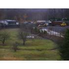
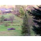
Submit your own pictures of this town and show them to the world
- OSM Map
- Google Map
- MSN Map
Population change since 2000: +0.2%
 |
| Males: 9,142 | |
| Females: 9,525 |
| Median resident age: | 41.8 years |
| New York median age: | 40.7 years |
Zip codes: 13492.
| Whitestown: | $71,794 |
| NY: | $79,557 |
Estimated per capita income in 2022: $37,235 (it was $19,507 in 2000)
Whitestown town income, earnings, and wages data
Estimated median house or condo value in 2022: $183,956 (it was $80,200 in 2000)
| Whitestown: | $183,956 |
| NY: | $400,400 |
Mean prices in 2022: all housing units: $197,131; detached houses: $205,775; townhouses or other attached units: $204,104; in 2-unit structures: $275,728; in 3-to-4-unit structures: $126,003; in 5-or-more-unit structures: $544,387; mobile homes: $61,833
Detailed information about poverty and poor residents in Whitestown, NY


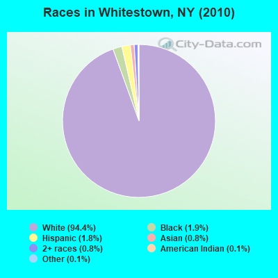
- 17,61594.4%White alone
- 3611.9%Black alone
- 3441.8%Hispanic
- 1530.8%Asian alone
- 1410.8%Two or more races
- 280.1%American Indian alone
- 200.1%Other race alone
- 50.03%Native Hawaiian and Other
Pacific Islander alone
Races in Whitestown detailed stats: ancestries, foreign born residents, place of birth
According to our research of New York and other state lists, there was 1 registered sex offender living in Whitestown, New York as of April 26, 2024.
The ratio of all residents to sex offenders in Whitestown is 18,667 to 1.
The ratio of registered sex offenders to all residents in this city is much lower than the state average.
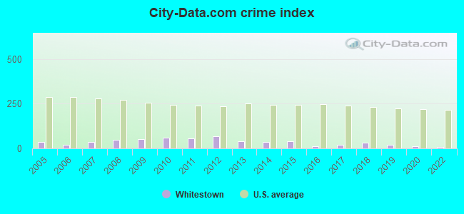
Type |
2009 |
2010 |
2011 |
2012 |
2013 |
2014 |
2015 |
2016 |
2017 |
2018 |
2019 |
2020 |
2022 |
|---|---|---|---|---|---|---|---|---|---|---|---|---|---|
| Murders (per 100,000) | 0 (0.0) | 0 (0.0) | 0 (0.0) | 0 (0.0) | 0 (0.0) | 0 (0.0) | 0 (0.0) | 0 (0.0) | 0 (0.0) | 0 (0.0) | 0 (0.0) | 0 (0.0) | 0 (0.0) |
| Rapes (per 100,000) | 0 (0.0) | 1 (10.9) | 0 (0.0) | 0 (0.0) | 0 (0.0) | 0 (0.0) | 0 (0.0) | 0 (0.0) | 0 (0.0) | 2 (21.8) | 0 (0.0) | 0 (0.0) | 0 (0.0) |
| Robberies (per 100,000) | 1 (10.8) | 1 (10.9) | 0 (0.0) | 1 (10.9) | 0 (0.0) | 0 (0.0) | 0 (0.0) | 0 (0.0) | 1 (10.9) | 0 (0.0) | 0 (0.0) | 0 (0.0) | 0 (0.0) |
| Assaults (per 100,000) | 1 (10.8) | 2 (21.8) | 1 (10.9) | 0 (0.0) | 0 (0.0) | 0 (0.0) | 0 (0.0) | 0 (0.0) | 0 (0.0) | 0 (0.0) | 0 (0.0) | 0 (0.0) | 1 (11.6) |
| Burglaries (per 100,000) | 11 (119.3) | 19 (207.5) | 22 (239.2) | 16 (174.1) | 13 (142.2) | 16 (171.9) | 12 (129.7) | 4 (43.1) | 7 (76.0) | 3 (32.7) | 5 (55.0) | 3 (33.5) | 1 (11.6) |
| Thefts (per 100,000) | 85 (922.0) | 53 (578.8) | 77 (837.0) | 103 (1,121) | 61 (667.3) | 55 (591.0) | 71 (767.4) | 23 (248.0) | 22 (238.9) | 19 (207.1) | 14 (153.9) | 17 (190.0) | 8 (93.0) |
| Auto thefts (per 100,000) | 1 (10.8) | 5 (54.6) | 3 (32.6) | 9 (97.9) | 3 (32.8) | 0 (0.0) | 0 (0.0) | 0 (0.0) | 1 (10.9) | 6 (65.4) | 9 (98.9) | 0 (0.0) | 1 (11.6) |
| Arson (per 100,000) | 0 (0.0) | 0 (0.0) | 0 (0.0) | 0 (0.0) | 0 (0.0) | 0 (0.0) | 0 (0.0) | 1 (10.8) | 0 (0.0) | 0 (0.0) | 0 (0.0) | 0 (0.0) | 0 (0.0) |
| City-Data.com crime index | 51.5 | 58.4 | 55.0 | 68.1 | 39.3 | 35.7 | 39.8 | 12.9 | 19.0 | 33.2 | 17.9 | 9.9 | 7.8 |
The City-Data.com crime index weighs serious crimes and violent crimes more heavily. Higher means more crime, U.S. average is 246.1. It adjusts for the number of visitors and daily workers commuting into cities.
Crime rate in Whitestown detailed stats: murders, rapes, robberies, assaults, burglaries, thefts, arson
Full-time law enforcement employees in 2021, including police officers: 5 (5 officers - 5 male; 0 female).
| Officers per 1,000 residents here: | 0.57 |
| New York average: | 3.28 |
 Recent articles from our blog. Our writers, many of them Ph.D. graduates or candidates, create easy-to-read articles on a wide variety of topics.

Ancestries: Irish (21.3%), Polish (21.2%), Italian (20.6%), German (19.2%), English (10.5%), French (4.9%).
Current Local Time: EST time zone
Incorporated on 3/7/1788
Land area: 27.2 square miles.
Population density: 686 people per square mile (low).
377 residents are foreign born (1.2% Europe, 0.6% Asia).
| This town: | 2.0% |
| New York: | 20.4% |
| Whitestown town: | 2.9% ($2,342) |
| New York: | 1.9% ($2,847) |
Nearest city with pop. 50,000+: Utica, NY  (4.3 miles , pop. 60,651).
Nearest city with pop. 200,000+: Rochester, NY (116.2 miles , pop. 219,773).
Nearest city with pop. 1,000,000+: Bronx, NY (173.9 miles , pop. 1,332,650).
Nearest cities:
), ), Latitude: 43.12 N, Longitude: 75.31 W
Area code commonly used in this area: 315

Whitestown, New York accommodation & food services, waste management - Economy and Business Data
Single-family new house construction building permits:
- 2022: 14 buildings, average cost: $144,200
- 2021: 1 building, cost: $250,000
- 2020: 3 buildings, average cost: $219,000
- 2019: 7 buildings, average cost: $198,400
- 2018: 3 buildings, average cost: $241,700
- 2017: 7 buildings, average cost: $263,300
- 2016: 14 buildings, average cost: $245,200
- 2015: 13 buildings, average cost: $245,200
- 2014: 17 buildings, average cost: $245,200
- 2013: 12 buildings, average cost: $245,200
- 2012: 13 buildings, average cost: $245,200
- 2011: 5 buildings, average cost: $202,900
- 2010: 7 buildings, average cost: $202,900
- 2009: 8 buildings, average cost: $235,200
- 2008: 6 buildings, average cost: $235,200
- 2007: 8 buildings, average cost: $235,200
- 2006: 31 buildings, average cost: $197,900
- 2005: 35 buildings, average cost: $197,900
- 2004: 35 buildings, average cost: $176,300
- 2003: 34 buildings, average cost: $195,000
- 2002: 36 buildings, average cost: $106,700
- 2001: 31 buildings, average cost: $106,700
- 2000: 29 buildings, average cost: $106,700
- 1999: 30 buildings, average cost: $106,700
- 1998: 25 buildings, average cost: $115,100
- 1997: 17 buildings, average cost: $117,700
| Here: | 4.2% |
| New York: | 4.4% |
- Health care (14.4%)
- Finance & insurance (12.2%)
- Educational services (10.6%)
- Public administration (6.0%)
- Accommodation & food services (4.7%)
- Professional, scientific, technical services (4.2%)
- Construction (4.1%)
- Construction (8.0%)
- Finance & insurance (7.8%)
- Public administration (7.8%)
- Educational services (7.0%)
- Health care (5.7%)
- Accommodation & food services (5.1%)
- Professional, scientific, technical services (4.6%)
- Health care (23.2%)
- Finance & insurance (16.6%)
- Educational services (14.4%)
- Accommodation & food services (4.4%)
- Public administration (4.3%)
- Professional, scientific, technical services (3.7%)
- Social assistance (3.2%)
- Other office and administrative support workers, including supervisors (5.5%)
- Other sales and related occupations, including supervisors (4.1%)
- Other management occupations, except farmers and farm managers (3.5%)
- Other production occupations, including supervisors (3.3%)
- Retail sales workers, except cashiers (3.0%)
- Registered nurses (2.9%)
- Health technologists and technicians (2.9%)
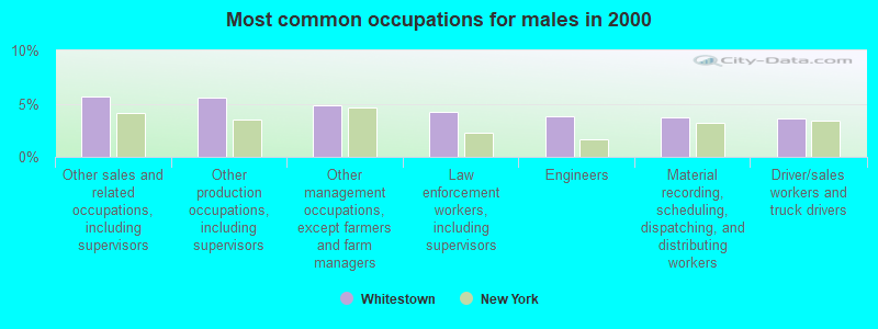
- Other sales and related occupations, including supervisors (5.7%)
- Other production occupations, including supervisors (5.6%)
- Other management occupations, except farmers and farm managers (4.8%)
- Law enforcement workers, including supervisors (4.3%)
- Engineers (3.8%)
- Material recording, scheduling, dispatching, and distributing workers (3.7%)
- Driver/sales workers and truck drivers (3.6%)
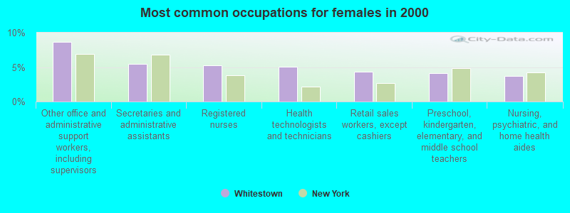
- Other office and administrative support workers, including supervisors (8.6%)
- Secretaries and administrative assistants (5.5%)
- Registered nurses (5.2%)
- Health technologists and technicians (5.1%)
- Retail sales workers, except cashiers (4.3%)
- Preschool, kindergarten, elementary, and middle school teachers (4.1%)
- Nursing, psychiatric, and home health aides (3.7%)
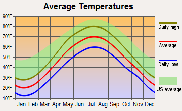
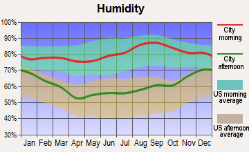
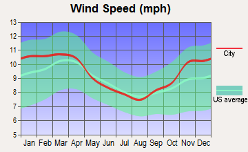
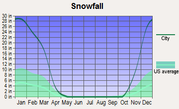
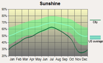
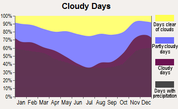
Average climate in Whitestown, New York
Based on data reported by over 4,000 weather stations
(lower is better)
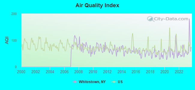
Air Quality Index (AQI) level in 2023 was 77.3. This is about average.
| City: | 77.3 |
| U.S.: | 72.6 |
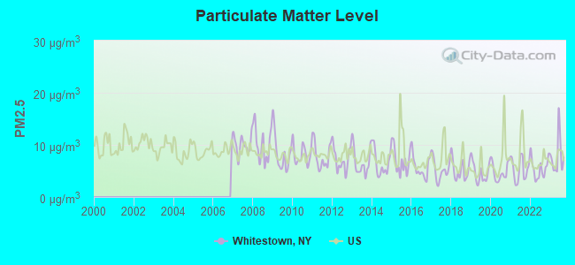
Particulate Matter (PM2.5) [µg/m3] level in 2023 was 7.86. This is about average. Closest monitor was 4.6 miles away from the city center.
| City: | 7.86 |
| U.S.: | 8.11 |
Tornado activity:
Whitestown-area historical tornado activity is below New York state average. It is 75% smaller than the overall U.S. average.
On 5/2/1983, a category F3 (max. wind speeds 158-206 mph) tornado 24.7 miles away from the Whitestown town center caused between $5,000,000 and $50,000,000 in damages.
On 7/10/1989, a category F4 (max. wind speeds 207-260 mph) tornado 44.3 miles away from the town center injured 20 people and caused between $5,000,000 and $50,000,000 in damages.
Earthquake activity:
Whitestown-area historical earthquake activity is significantly above New York state average. It is 68% smaller than the overall U.S. average.On 10/7/1983 at 10:18:46, a magnitude 5.3 (5.1 MB, 5.3 LG, 5.1 ML, Class: Moderate, Intensity: VI - VII) earthquake occurred 75.2 miles away from the city center
On 4/20/2002 at 10:50:47, a magnitude 5.3 (5.3 ML, Depth: 3.0 mi) earthquake occurred 125.3 miles away from the city center
On 4/20/2002 at 10:50:47, a magnitude 5.2 (5.2 MB, 4.2 MS, 5.2 MW, 5.0 MW) earthquake occurred 123.3 miles away from Whitestown center
On 6/17/1991 at 08:53:16, a magnitude 4.1 (4.0 MB, 4.0 LG, Depth: 3.1 mi, Class: Light, Intensity: IV - V) earthquake occurred 46.8 miles away from Whitestown center
On 8/23/2011 at 17:51:04, a magnitude 5.8 (5.8 MW, Depth: 3.7 mi) earthquake occurred 386.1 miles away from the city center
On 1/19/1982 at 00:14:42, a magnitude 4.7 (4.5 MB, 4.7 MD, 4.5 LG) earthquake occurred 188.5 miles away from the city center
Magnitude types: regional Lg-wave magnitude (LG), body-wave magnitude (MB), duration magnitude (MD), local magnitude (ML), surface-wave magnitude (MS), moment magnitude (MW)
Natural disasters:
The number of natural disasters in Oneida County (23) is greater than the US average (15).Major Disasters (Presidential) Declared: 12
Emergencies Declared: 9
Causes of natural disasters: Storms: 9, Floods: 7, Tropical Storms: 3, Hurricanes: 2, Snows: 2, Snowstorms: 2, Winds: 2, Blizzard: 1, Ice Storm: 1, Power Outage: 1, Tornado: 1, Winter Storm: 1, Other: 2 (Note: some incidents may be assigned to more than one category).
Hospitals and medical centers near Whitestown:
- ST LUKES HOME (Nursing Home, about 3 miles away; UTICA, NY)
- FAXTON-ST LUKE'S HEALTHCARE Acute Care Hospitals (about 3 miles away; UTICA, NY)
- FAXTON - ST LUKES HEALTHCARE ALLEN CALDER (Nursing Home, about 3 miles away; UTICA, NY)
- PRESBYTERIAN HOME FOR CENTRAL NEW YORK INC (Nursing Home, about 3 miles away; NEW HARTFORD, NY)
- HOSPICE AND PALLIATIVE CARE INC NEW HARTFORD (Hospital, about 3 miles away; NEW HARTFORD, NY)
- UCPA OF THE UTICA AREA (Hospital, about 3 miles away; MARCY, NY)
- UTICA PYSCHIATRIC CENTER (Hospital, about 4 miles away; UTICA, NY)
Amtrak stations near Whitestown:
- 5 miles: UTICA (321 MAIN ST.) . Services: ticket office, partially wheelchair accessible, enclosed waiting area, public restrooms, public payphones, snack bar, free short-term parking, call for car rental service, taxi stand, intercity bus service, public transit connection.
- 9 miles: ROME (6599 MARTIN ST.) . Services: enclosed waiting area, public restrooms, public payphones, full-service food facilities, free short-term parking, free long-term parking, call for car rental service, call for taxi service, public transit connection.
Colleges/universities with over 2000 students nearest to Whitestown:
- Utica College (about 3 miles; Utica, NY; Full-time enrollment: 2,952)
- Mohawk Valley Community College (about 6 miles; Utica, NY; FT enrollment: 5,693)
- Herkimer County Community College (about 17 miles; Herkimer, NY; FT enrollment: 2,774)
- Morrisville State College (about 22 miles; Morrisville, NY; FT enrollment: 2,823)
- Colgate University (about 24 miles; Hamilton, NY; FT enrollment: 3,094)
- Le Moyne College (about 40 miles; Syracuse, NY; FT enrollment: 3,041)
- Syracuse University (about 43 miles; Syracuse, NY; FT enrollment: 20,717)
Private high school in Whitestown:
- WHITESTONE ACADEMY (Students: 128, Location: 15034 12TH AVE, Grades: 7-12)
Public elementary/middle schools in Whitestown:
- JHS 194 WILLIAM CARR (Students: 1,128, Location: 154-60 17TH AVE, Grades: 6-8)
- PS 79 FRANCIS LEWIS (Students: 814, Location: 147-27 15TH DR, Grades: PK-5)
- PS 209 CLEARVIEW GARDENS (Students: 567, Location: 16-10 UTOPIA PKWY, Grades: PK-5)
- PS 193 ALFRED J KENNEDY (Students: 507, Location: 152-20 11TH AVE, Grades: PK-5)
- PS 184 FLUSHING MANOR (Students: 471, Location: 163-15 21ST RD, Grades: PK-5)
Private elementary/middle schools in Whitestown:
- ST LUKES SCHOOL (Students: 505, Location: 1601 150TH PL, Grades: PK-8)
- HOLY TRINITY SCHOOL (Students: 261, Location: 1445 143RD ST, Grades: PK-8)
- EFSTATHIOS & STAMATIKI VALIOTS GREEK-AMERICAN SCHO (Students: 109, Location: 1203 150TH ST, Grades: PK-1)
- NORTH SIDE SCHOOL (Students: 99, Location: 1650 UTOPIA PKWY, Grades: PK-1)
Points of interest:
Notable locations in Whitestown: Twin Ponds Golf Club (A), Shamrock Golf and Country Club (B), Oriskany Hills Golf Club (C), Hidden Valley Golf Club (D), Domenico's Golf Course (E), Benson Farms (F), Sadaquada Golf Club (G), New York Mills Fire Department (H), American Legion Post 1113 (I), Dunham Public Library (J), Yorkville Fire and Hose Company (K), Eastern Star Nursing Home and Infirmary (L), New York Mills Public Library (M), Oriskany Public Library (N), Oriskany Fire Department (O), Whitesboro Fire Department (P). Display/hide their locations on the map
Shopping Center: Whitestown Shopping Plaza Shopping Center (1). Display/hide its location on the map
Churches in Whitestown include: Waterbury Memorial Presbyterian Church (A), Saint Stephen's Church (B), Clinton Road Baptist Church (C), Seventh Day Adventist Church (D), The Church of Jesus Christ of Latter Day Saints (E), Trinity United Methodist Church (F), Harts Hill Baptist Church (G), Saint Mary's Roman Catholic Church (H), Sacred Heart Polish National Church (I). Display/hide their locations on the map
Cemeteries: Saint Joseph Cemetery (1), Glenside Cemetery (2), Grandview Cemetery (3), Holy Trinity Cemetery (4). Display/hide their locations on the map
Creeks: Deans Creek (A), Oriskany Creek (B), Mud Creek (C). Display/hide their locations on the map
Park in Whitestown: Pulaski Park (1). Display/hide its location on the map
Birthplace of: Canvass White - Civil engineer, Frances Miriam Whitcher - Humorist.
| This town: | 2.3 people |
| New York: | 2.6 people |
| This town: | 62.4% |
| Whole state: | 63.5% |
| This town: | 6.7% |
| Whole state: | 6.8% |
Likely homosexual households (counted as self-reported same-sex unmarried-partner households)
- Lesbian couples: 0.4% of all households
- Gay men: 0.2% of all households
| This town: | 9.1% |
| Whole state: | 14.6% |
| This town: | 3.3% |
| Whole state: | 7.4% |
People in group quarters in Whitestown in 2010:
- 469 people in local jails and other municipal confinement facilities
- 82 people in nursing facilities/skilled-nursing facilities
- 48 people in residential treatment centers for juveniles (non-correctional)
- 27 people in group homes intended for adults
- 12 people in residential treatment centers for adults
- 3 people in other noninstitutional facilities
People in group quarters in Whitestown in 2000:
- 421 people in local jails and other confinement facilities (including police lockups)
- 78 people in nursing homes
- 78 people in homes for abused, dependent, and neglected children
- 24 people in mental (psychiatric) hospitals or wards
- 15 people in homes for the mentally retarded
For population 15 years and over in Whitestown:
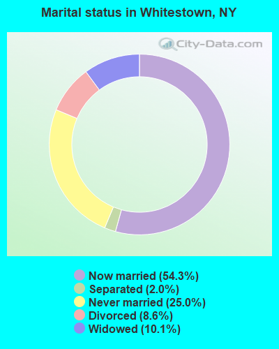
- Never married: 25.0%
- Now married: 54.3%
- Separated: 2.0%
- Widowed: 10.1%
- Divorced: 8.6%
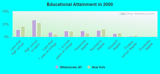
For population 25 years and over in Whitestown:
- High school or higher: 85.8%
- Bachelor's degree or higher: 21.1%
- Graduate or professional degree: 8.3%
- Unemployed: 4.0%
- Mean travel time to work (commute): 17.2 minutes
| Here: | 10.9 |
| New York average: | 14.2 |
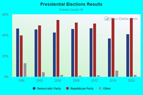
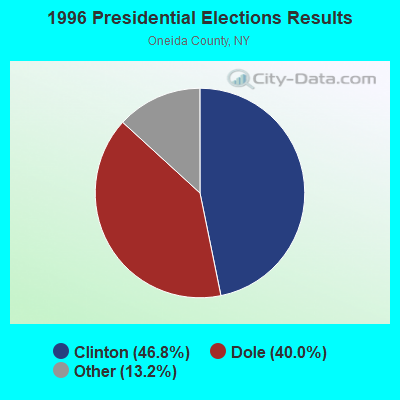
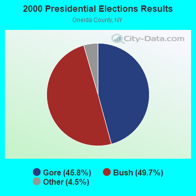
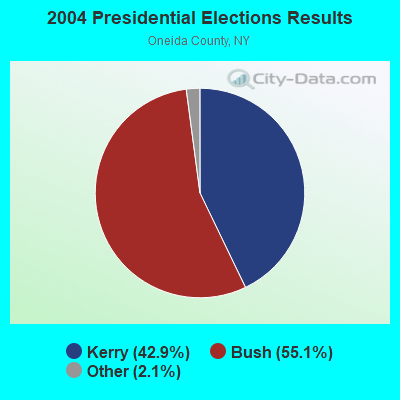
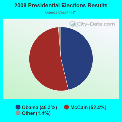
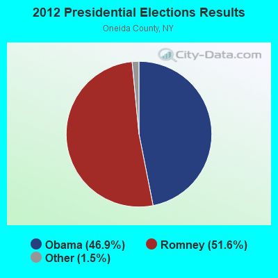
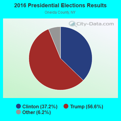
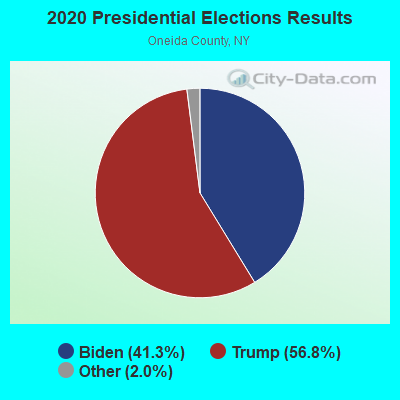
Graphs represent county-level data. Detailed 2008 Election Results
Religion statistics for Whitestown, NY (based on Oneida County data)
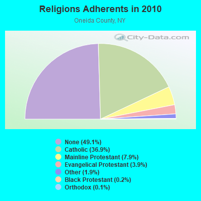
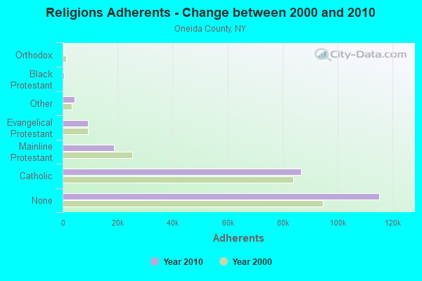
| Religion | Adherents | Congregations |
|---|---|---|
| Catholic | 86,750 | 51 |
| Mainline Protestant | 18,610 | 95 |
| Evangelical Protestant | 9,119 | 75 |
| Other | 4,416 | 16 |
| Black Protestant | 504 | 4 |
| Orthodox | 270 | 3 |
| None | 115,209 | - |
Food Environment Statistics:
| Oneida County: | 2.12 / 10,000 pop. |
| State: | 4.13 / 10,000 pop. |
| Oneida County: | 0.13 / 10,000 pop. |
| State: | 0.06 / 10,000 pop. |
| Here: | 0.47 / 10,000 pop. |
| New York: | 0.92 / 10,000 pop. |
| This county: | 3.24 / 10,000 pop. |
| New York: | 1.68 / 10,000 pop. |
| Oneida County: | 8.85 / 10,000 pop. |
| State: | 8.82 / 10,000 pop. |
| This county: | 8.8% |
| New York: | 8.2% |
| Oneida County: | 24.4% |
| State: | 23.8% |
| This county: | 15.0% |
| New York: | 15.6% |
Strongest AM radio stations in Whitestown:
- WIBX (950 AM; 5 kW; UTICA, NY; Owner: REGENT LICENSEE OF UTICA/ROME, INC.)
- WRUN (1150 AM; 5 kW; UTICA, NY)
- WTLB (1310 AM; 5 kW; UTICA, NY; Owner: GALAXY COMMUNICATIONS, L.P.)
- WUTQ (1550 AM; 1 kW; UTICA, NY)
- WADR (1480 AM; 5 kW; REMSEN, NY; Owner: CLEAR CHANNEL BROADCASTING LICENSES, INC.)
- WGY (810 AM; 50 kW; SCHENECTADY, NY; Owner: CLEAR CHANNEL BROADCASTING LICENSES, INC.)
- WPTR (1540 AM; 50 kW; ALBANY, NY; Owner: KIMTRON, INC.)
- WSYR (570 AM; 5 kW; SYRACUSE, NY; Owner: CLEAR CHANNEL BROADCASTING LICENSES, INC.)
- WHEN (620 AM; 5 kW; SYRACUSE, NY; Owner: CLEAR CHANNEL BROADCASTING LICENSES, INC.)
- WNNZ (640 AM; 50 kW; WESTFIELD, MA; Owner: CLEAR CHANNEL BROADCASTING LICENSES, INC.)
- WRNY (1350 AM; 0 kW; ROME, NY; Owner: CLEAR CHANNEL BROADCASTING LICENSES, INC.)
- WNRS (1420 AM; 1 kW; HERKIMER, NY; Owner: ARJUNA BROADCASTING CORP.)
- WHAM (1180 AM; 50 kW; ROCHESTER, NY; Owner: CITICASTERS LICENSES, L.P.)
Strongest FM radio stations in Whitestown:
- WKVU (100.7 FM; UTICA, NY; Owner: EDUCATIONAL MEDIA FOUNDATION)
- WOUR (96.9 FM; UTICA, NY; Owner: CLEAR CHANNEL BROADCASTING LICENSES, INC.)
- WUNY (89.5 FM; UTICA, NY; Owner: PUBLIC BC COUNCIL OF CENTRAL NY, INC)
- WLZW (98.7 FM; UTICA, NY; Owner: REGENT LICENSEE OF UTICA/ROME, INC.)
- WKLL (94.9 FM; FRANKFORT, NY; Owner: GALAXY COMMUNICATIONS, L.P.)
- WRCK (107.3 FM; UTICA, NY; Owner: GALAXY COMMUNICATIONS, L.P.)
- WFRG-FM (104.3 FM; UTICA, NY; Owner: REGENT LICENSEE OF UTICA/ROME, INC.)
- WSKS (97.9 FM; WHITESBORO, NY; Owner: CLEAR CHANNEL BROADCASTING LICENSES, INC.)
- WRBY (102.5 FM; ROME, NY; Owner: CLEAR CHANNEL BROADCASTING LICENSES, INC.)
- WODZ-FM (96.1 FM; ROME, NY; Owner: REGENT LICENSEE OF UTICA/ROME, INC.)
- WBGK (99.7 FM; NEWPORT VILLAGE, NY; Owner: ROSER COMMUNICATIONS NETWORK, INC.)
- WUCL (93.5 FM; REMSEN, NY; Owner: CLEAR CHANNEL BROADCASTING LICENSES, INC.)
- WMCR-FM (106.3 FM; ONEIDA, NY; Owner: WARREN BROADCASTING CO. INC.)
- WPNR-FM (90.7 FM; UTICA, NY; Owner: UTICA COLLEGE)
- WXUR (92.7 FM; HERKIMER, NY; Owner: ARJUNA BROADCASTING CORP.)
- WWDG (105.1 FM; DERUYTER, NY; Owner: CLEAR CHANNEL BROADCASTING LICENSES, INC.)
- WJIV (101.9 FM; CHERRY VALLEY, NY; Owner: CHRISTIAN BROADCASTING SYSTEM, LTD.)
- WSKU (105.5 FM; LITTLE FALLS, NY; Owner: CLEAR CHANNEL BROADCASTING LICENSES, INC.)
- WHCL-FM (88.7 FM; CLINTON, NY; Owner: TRUSTEES OF HAMILTON COLLEGE)
- WBUG-FM (101.1 FM; FORT PLAIN, NY; Owner: ROSER COMMUNICATIONS NETWORK, INC.)
TV broadcast stations around Whitestown:
- W59AU (Channel 59; UTICA, NY; Owner: PUBLIC B/CING.COUNCIL,CENTRAL N. Y.)
- WFXV (Channel 33; UTICA, NY; Owner: QUORUM OF UTICA LICENSE, LLC)
- WUTR (Channel 20; UTICA, NY; Owner: CENTRAL NY NEWS, INC.)
- WPNY-LP (Channel 11; UTICA, ETC., NY; Owner: QUORUM OF UTICA LICENSE, LLC)
- WKTV (Channel 2; UTICA, NY; Owner: SMITH TELEVISION OF NEW YORK LICENSE HOLDINGS, INC.)
- W53AM (Channel 53; UTICA, NY; Owner: QUORUM OF UTICA LICENSE, LLC)
- W51CV (Channel 51; UTICA, NY; Owner: TRINITY BROADCASTING NETWORK)
- W12BZ (Channel 12; ROME, NY; Owner: KEVIN O'KANE)
- WIXT-TV (Channel 9; SYRACUSE, NY; Owner: CENTRAL NY NEWS, INC.)
- WSPX-TV (Channel 56; SYRACUSE, NY; Owner: PAXSON SYRACUSE LICENSE, INC.)
- WCNY-TV (Channel 24; SYRACUSE, NY; Owner: PUBLIC BROADCASTING COUNCIL OF CENTRAL NEW YORK)
- WNYS-TV (Channel 43; SYRACUSE, NY; Owner: RKM MEDIA, INC.)
- W27BJ (Channel 27; UTICA, NY; Owner: SOUL'S HARBOR PENTECOSTAL CHURCH)
- W13BR (Channel 13; ONEIDA, NY; Owner: KEVIN O'KANE)
- W15BR (Channel 15; ONEIDA, NY; Owner: RENARD COMMUNICATIONS CORP.)
- National Bridge Inventory (NBI) Statistics
- 10Number of bridges
- 174ft / 53.4mTotal length
- $21,666,000Total costs
- 68,259Total average daily traffic
- 7,751Total average daily truck traffic
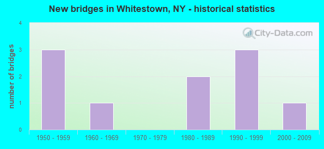
- New bridges - historical statistics
- 31950-1959
- 11960-1969
- 21980-1989
- 31990-1999
- 12000-2009
FCC Registered Antenna Towers:
61 (See the full list of FCC Registered Antenna Towers in Whitestown)FCC Registered Broadcast Land Mobile Towers:
4- 911 CENTER, Base Rd Near Judd Rd (Lat: 43.155000 Lon: -75.377778), Type: Tower, Structure height: 38.1 m, Overall height: 39 m, Call Sign: KNFM530,
Assigned Frequencies: 45.8800 MHz, Grant Date: 10/07/2021, Expiration Date: 12/31/2031, Registrant: Oneida County Emergency Services, 120 Base Rd, Oriskany, NY 13424, Phone: (315) 765-2522, Fax: (315) 765-2529, Email:
- 911 CENTER, Base Road Near Judd Rd (Lat: 43.155000 Lon: -75.377778), Type: Tower, Structure height: 38.1 m, Overall height: 39 m, Call Sign: WGR555,
Assigned Frequencies: 452.125 MHz, Grant Date: 10/17/2023, Expiration Date: 12/31/2033, Registrant: Oneida County Emergency Services, 120 Base Rd, Oriskany, NY 13424, Phone: (315) 765-2522, Fax: (315) 765-2529, Email:
- 120 Base Road (Lat: 43.155000 Lon: -75.377778), Type: Tower, Structure height: 38.1 m, Overall height: 39 m, Call Sign: WQDS377,
Assigned Frequencies: 45.4000 MHz, 45.2400 MHz, Grant Date: 08/13/2015, Expiration Date: 10/19/2025, Certifier: Lawrence R Mitchell, Registrant: Nys Div. Of Homeland Security And Emergency Services, 1220 Washington Ave, Bldg. 7a, Ste 710, State Office Campus, Albany, NY 12242, Phone: (518) 322-4912, Fax: (518) 322-4975, Email:
- Base Rd Near Judd Rd (Lat: 43.155000 Lon: -75.377778), Type: Tower, Structure height: 38.1 m, Overall height: 39 m, Call Sign: WQLM608,
Assigned Frequencies: 453.025 MHz, Grant Date: 01/17/2020, Expiration Date: 03/09/2030, Certifier: Andre Esposito, Registrant: Jpj Electronic Communications, Inc, 1 W Whitesboro Street, Yorkville, NY 13495, Phone: (315) 733-8495, Fax: (315) 733-4925, Email:
FCC Registered Microwave Towers:
6- 6065 JUDD RD, 6065 Judd Rd (Lat: 43.155556 Lon: -75.374722), Type: Tower, Structure height: 18.3 m, Overall height: 21 m, Call Sign: WPVU656,
Assigned Frequencies: 2145.20 MHz, 2146.80 MHz, Grant Date: 08/22/2002, Expiration Date: 02/22/2003, Cancellation Date: 04/15/2003, Certifier: Joseph M Jones, Registrant: Oneida County Emergency Services, 120 Base Rd, Oriskany, NY 13424, Phone: (315) 765-2525, Fax: (315) 765-2535, Email:
- 6065 JUDD RD, 6065 Judd Rd (Lat: 43.155556 Lon: -75.374722), Type: Tower, Structure height: 18.3 m, Overall height: 21 m, Call Sign: WPWF412,
Assigned Frequencies: 2145.20 MHz, 2146.80 MHz, Grant Date: 11/04/2002, Expiration Date: 11/04/2012, Cancellation Date: 08/21/2008, Certifier: Joseph M Jones, Registrant: Oneida County Emergency Services, 120 Base Rd, Oriskany, NY 13424, Phone: (315) 765-2525, Fax: (315) 765-2535, Email:
- 120 BASE RD, Base Rd Near Judd Rd (Lat: 43.155000 Lon: -75.377778), Type: Tower, Structure height: 38.1 m, Overall height: 39 m, Call Sign: WPWK616,
Assigned Frequencies: 933.975 MHz, 933.775 MHz, 933.575 MHz, Grant Date: 09/13/2022, Expiration Date: 12/09/2032, Certifier: Joseph M Jones, Registrant: Oneida County Emergency Services, 120 Base Rd, Oriskany, NY 13424, Phone: (315) 765-2522, Fax: (315) 765-2529, Email:
- 911 120 BASE, Base Rd Near Judd Rd (Lat: 43.155000 Lon: -75.377778), Type: Ltower, Structure height: 38.1 m, Overall height: 39 m, Call Sign: WQIP750,
Assigned Frequencies: 5974.85 MHz, 6123.10 MHz, 6137.92 MHz, 6137.92 MHz, 6137.92 MHz, 6137.92 MHz, 6137.92 MHz, 6137.92 MHz, 11565.0 MHz, 11565.0 MHz... (+18 more), Grant Date: 01/10/2018, Expiration Date: 04/08/2028, Certifier: Joseph M Jones, Registrant: Oneida County Emergency Services, 120 Base Rd, Oriskany, NY 13424, Phone: (315) 765-2522, Fax: (315) 765-2529, Email:
- 6065 JUDD RD, 6065 Judd Rd (Lat: 43.155556 Lon: -75.374722), Type: Tower, Structure height: 24.4 m, Overall height: 30.5 m, Call Sign: WQNX753,
Assigned Frequencies: 934.625 MHz, Grant Date: 06/29/2011, Expiration Date: 06/29/2021, Cancellation Date: 10/02/2021, Certifier: Joseph M Jones, Registrant: Oneida County Emergency Services, 120 Base Rd, Oriskany, NY 13424, Phone: (315) 765-2525, Fax: (315) 765-2535, Email:
- SYSYR00453A, 1 Championship Way (Lat: 43.126722 Lon: -75.346778), Type: Ltower, Structure height: 56.4 m, Overall height: 61 m, Call Sign: WRTQ569,
Assigned Frequencies: 11345.0 MHz, 11345.0 MHz, 11345.0 MHz, 11345.0 MHz, 11345.0 MHz, 11345.0 MHz, 11345.0 MHz, 11345.0 MHz, 11345.0 MHz, 11345.0 MHz, 11345.0 MHz, 11345.0 MHz, Grant Date: 07/13/2022, Expiration Date: 07/13/2032, Certifier: Alison A Minea, Registrant: Dish Wireless L.L.C., 9601 S Meridan Blvd, Englewood, CO 80112, Phone: (202) 463-3709, Email:
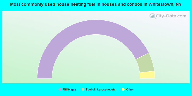
- 85.7%Utility gas
- 10.2%Fuel oil, kerosene, etc.
- 2.4%Electricity
- 0.6%Wood
- 0.6%Other fuel
- 0.5%Bottled, tank, or LP gas
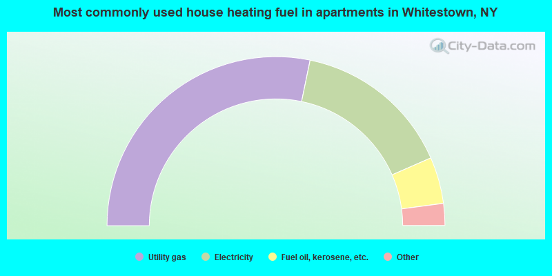
- 56.5%Utility gas
- 30.4%Electricity
- 8.9%Fuel oil, kerosene, etc.
- 1.9%Bottled, tank, or LP gas
- 1.3%Other fuel
- 0.9%No fuel used
Whitestown compared to New York state average:
- Median house value below state average.
- Unemployed percentage significantly below state average.
- Black race population percentage significantly below state average.
- Hispanic race population percentage significantly below state average.
- Foreign-born population percentage significantly below state average.
- Renting percentage below state average.
- Length of stay since moving in significantly above state average.
- Number of rooms per house significantly below state average.
- House age significantly below state average.
- Institutionalized population percentage above state average.
Whitestown on our top lists:
- #12 on the list of "Top 101 cities with largest percentage of males in industries: metals and minerals, except petroleum, merchant wholesalers (population 5,000+)"
- #15 on the list of "Top 101 cities with largest percentage of males in industries: sporting goods, camera, and hobby and toy stores (population 5,000+)"
- #19 on the list of "Top 101 cities with largest percentage of males in industries: department and other general merchandise stores (population 5,000+)"
- #24 on the list of "Top 101 cities with largest percentage of males in occupations: food and beverage serving workers except waiters/waitresses (population 5,000+)"
- #26 on the list of "Top 101 cities with largest percentage of males in occupations: legal support workers (population 5,000+)"
- #28 on the list of "Top 101 cities with largest percentage of females in industries: metals and minerals, except petroleum, merchant wholesalers (population 5,000+)"
- #33 on the list of "Top 101 cities with largest percentage of males in occupations: counselors, social workers, and other community and social service specialists (population 5,000+)"
- #44 on the list of "Top 101 cities with largest percentage of females in industries: health care (population 5,000+)"
- #52 on the list of "Top 101 cities with largest percentage of males in occupations: customer service representatives (population 5,000+)"
- #57 on the list of "Top 101 cities with largest percentage of females in industries: finance and insurance (population 5,000+)"
- #58 on the list of "Top 101 cities with the largest percentage of people in homes for abused, dependent, and neglected children (population 1,000+)"
- #61 on the list of "Top 101 cities with largest percentage of females in industries: sewing, needlework, and piece goods stores (population 5,000+)"
- #65 on the list of "Top 101 cities with largest percentage of males in occupations: cashiers (population 5,000+)"
- #69 on the list of "Top 101 cities with the lowest number of police officers per 1000 residents (population 5,000+)"
- #79 on the list of "Top 101 cities with largest percentage of females in occupations: other financial specialists (population 5,000+)"
- #100 on the list of "Top 101 cities with largest percentage of males in industries: farm product raw materials merchant wholesalers (population 5,000+)"
- #100 on the list of "Top 101 cities with largest percentage of males in industries: miscellaneous manufacturing (population 5,000+)"
- #20 on the list of "Top 101 counties with the largest increase in the number of births per 1000 residents 2000-2006 to 2007-2013 (pop 50,000+)"
- #24 on the list of "Top 101 counties with the lowest percentage of residents relocating from other counties between 2010 and 2011"
- #35 on the list of "Top 101 counties with the lowest percentage of residents relocating to other counties in 2011"
- #57 on the list of "Top 101 counties with the largest number of people moving out compared to moving in (pop. 50,000+)"
- #65 on the list of "Top 101 counties with the most Catholic congregations"