Property valuation of Lynch Road, Coward, SC: 925, 929, 940, 1012, 1036, 1115, 1226, 1242, 1254, 1263, 1263 (tax assessments)

Listed properties vs overall distribution of properties in Coward, SC:
925 Lynch Road
Coward, SC
Find on map >>
Owner: MORRIS STEPHANY R
Ownership: Private
Property use: Residential Improved
Topography: Level
Street access: Paved
Utilities: Well, Septic, Electricity
Fronting traffic: Light
Land value: $9,550
Building value: $60,248
Total assessed value for property: $69,798
Land area: 3,963,960 square feet
Number of buildings on parcel: 2
Assessment for fiscal year: 2012
929 Lynch Road
Coward, SC
Find on map >>
Owner: AVANT ROGER (LE)
Ownership: Private
Property use: Residential Vacant
Topography: Level
Street access: Paved
Utilities: Well, Septic, Electricity
Fronting traffic: Light
Land value: $8,550
Building value: $4,655
Total assessed value for property: $13,205
Land area: 3,267,000 square feet
Number of buildings on parcel: 1
Assessment for fiscal year: 2012
940 Lynch Road
Coward, SC
Find on map >>
Owner: WEATHERFORD GLENDA L
Ownership: Private
Property use: Residential Vacant
Topography: Level
Street access: Paved
Utilities: Well, Septic, Electricity
Fronting traffic: Med.
Land value: $13,100
Total assessed value for property: $13,100
Land area: 6,229,080 square feet
Assessment for fiscal year: 2012
1012 Lynch Road
Coward, SC
Find on map >>
Owner: CARROWAY PAMELA S
Ownership: Private
Property use: Residential Vacant
Topography: Level
Street access: Paved
Utilities: Well, Septic, Electricity
Fronting traffic: Med.
Land value: $9,550
Total assessed value for property: $9,550
Land area: 4,356,000 square feet
Assessment for fiscal year: 2012
1036 Lynch Road
Coward, SC
Find on map >>
Owner: MCCUTCHEON NETTIE BILLE
Ownership: Private
Property use: Farm Improved
Topography: Level
Street access: Paved
Utilities: Well, Septic, Electricity
Fronting traffic: No-Outlet St.
Land value: $30,159
Building value: $80,100
Total assessed value for property: $110,259
Number of buildings on parcel: 3
Assessment for fiscal year: 2012
1115 Lynch Road
Coward, SC
Find on map >>
Owner: FILYAW HARRY L
Ownership: Private
Property use: Residential Auxiliary
Topography: Level
Street access: Paved
Utilities: Well, Septic, No Utilities
Fronting traffic: Light
Land value: $9,550
Building value: $43,566
Total assessed value for property: $53,116
Land area: 4,094,640 square feet
Number of buildings on parcel: 2
Assessment for fiscal year: 2012
1226 Lynch Road
Coward, SC
Find on map >>
Owner: MATTHEWS MARK & DEBRA
Ownership: Private
Property use: Residential Vacant
Topography: Level
Street access: Paved
Utilities: Well, Septic, Electricity
Fronting traffic: Med.
Land value: $17,550
Building value: $3,360
Total assessed value for property: $20,910
Land area: 17,424,000 square feet
Number of buildings on parcel: 1
Assessment for fiscal year: 2012
1242 Lynch Road
Coward, SC
Find on map >>
Owner: LAMB JASON E & TRACY P
Ownership: Private
Property use: Residential Vacant
Topography: Level
Utilities: Public Sewer, Well, Septic
Land value: $13,550
Total assessed value for property: $13,550
Land area: 8,712,000 square feet
Assessment for fiscal year: 2012
Coward, SC
Find on map >>
Owner: LAMB JASON E & TRACY P
Ownership: Private
Property use: Residential Vacant
Topography: Level
Utilities: Public Sewer, Well, Septic
Land value: $13,550
Total assessed value for property: $13,550
Land area: 8,712,000 square feet
Assessment for fiscal year: 2012
1254 Lynch Road
Coward, SC
Find on map >>
Owner: SOUTHEASTERN SAND LLC
Ownership: Private
Property use: Farm Vacant
Topography: Level
Street access: Unpaved
Utilities: Electricity
Fronting traffic: Light
Land value: $923
Total assessed value for property: $923
Land area: 57,586,320 square feet
Assessment for fiscal year: 2012
1263 Lynch Road
Coward, SC
Find on map >>
Owner: MARTIN DALLAS J JR
Ownership: Private
Property use: Residential Improved
Topography: Level
Street access: Paved
Utilities: Well, Septic, Electricity
Fronting traffic: Light
Land value: $13,550
Building value: $45,386
Total assessed value for property: $58,936
Land area: 6,054,840 square feet
Number of buildings on parcel: 1
Assessment for fiscal year: 2012
Business Search
14 Million Businesses in 12,000 Categories
14 Million Businesses in 12,000 Categories
Settings
X

Recently Added Photos
Greenville, SC

Columbia, SC

Columbia, SC

Columbia, SC

Greenville, SC

Greer, SC

Fountain Inn, SC

Greenville, SC

Columbia, SC

Columbia, SC

Taylors, SC

Greenville, SC
Request disassociating your name from street-level assessment address

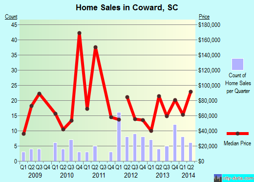
Recent home sales, price trends, and home value evaluator powered by Onboard Informatics
© 2024 Onboard Informatics. Information is deemed reliable but not guaranteed.
© 2024 Onboard Informatics. Information is deemed reliable but not guaranteed.
Some parts © 2024 Advameg, Inc.
Compilation, repackaging, or reproduction prohibited. Users are forewarned that it is incumbent upon them to verify information with the responsible state agency. Advameg, Inc. does not guarantee the data presented is up-to-date nor does it assume responsibility for updating it. Therefore any names, owners or addresses may have changed. Use of any information published here to contact the persons might be prohibited by the law.