Welcome to City-Data.com Forum!
U.S. CitiesCity-Data Forum Index
Go Back   City-Data Forum > U.S. Forums > General U.S. > City vs. City
 [Register]
Please register to participate in our discussions with 2 million other members - it's free and quick! Some forums can only be seen by registered members. After you create your account, you'll be able to customize options and access all our 15,000 new posts/day with fewer ads.
View detailed profile (Advanced) or search
site with Google Custom Search

Search Forums  (Advanced)
Reply Start New Thread
 
Old 08-23-2011, 09:13 AM
 
Location: Philadelphia
11,998 posts, read 12,927,632 times
Reputation: 8365

Advertisements

IMO Philadelphia feels much larger than Boston when looking at the respective cities but when looking at the entire metros Boston wins. Boston metro has tons of room for expansion as it is somewhat isolated for a Bos-Wash city. The Boston CSA has 3 state capitals in it which is pretty remarkable, I don't think any other city can say the same. This alone inflates Boston's sphere of influence throughout the New England area.
Reply With Quote Quick reply to this message

 
Old 08-23-2011, 09:17 AM
 
Location: Underneath the Pecan Tree
15,982 posts, read 35,199,026 times
Reputation: 7428
I honestly don't believe you can compare the city vibes when the cities are so different and originated in different time periods.

Something like this works to me:

Urban:
1.NYC
2.Chicago
3.Philly
4.Boston
5.San Francisco.
on and on.......

Suburban:
1.Los Angeles
2.Houston
3.Atlanta
on and on.......
Reply With Quote Quick reply to this message
 
Old 08-23-2011, 09:17 AM
 
Location: Los Altos Hills, CA
36,653 posts, read 67,487,099 times
Reputation: 21229
As far as 10,000+persons per square mile, here is info on the Bay Area:
Quote:
The San Francisco Bay Area, located in Northern California, consists of nine counties, 101 cities, and comprises 7,000 square miles. All of the region's nine counties share the San Francisco Bay. With 7.1 million residents, the San Francisco Bay Area is the fifth most populous metropolitan area in the United States.

The Bay Area has a land area of 4.4 million acres (excluding bay waters and large lakes). In 2000, approximately 16 percent (or about 700,000 acres) of the region's total acreage was developed for urban use. Of those developed acres, 61 percent are residential and 42 percent are non-residential (e.g., employment, government, schools, and major infrastructure).

San Francisco Bay Area Vision Project
And so, in 2000, The Bay Area fit 7.1 Million people into 1,093 square miles of developed land which comes out to 6,495 persons per square mile.

If we only weigh total residential land usage(61% of 1,093 square miles) then the Bay Area fits 7.1 Million people into 667 sq miles and that equals 10,644 persons per square mile overall.
Reply With Quote Quick reply to this message
 
Old 08-23-2011, 09:19 AM
 
2,563 posts, read 3,624,695 times
Reputation: 3434
NYC

- big gap -

Chicago

- big gap -

then, in order

Philadelphia
San Francisco
Boston
Los Angeles
Reply With Quote Quick reply to this message
 
Old 08-23-2011, 09:23 AM
 
Location: Philadelphia, PA
1,335 posts, read 1,661,088 times
Reputation: 344
If you look at Philly's 2010 census data, where Philly gained 8,000 residents, one of the striking things is the pattern of gentrification. Whole neighborhoods are experiencing turnarounds. Philly is rightly accused of having too much slum and ghetto, but these distressed areas are essentially undeveloped land, right in the city proper. The ghetto may be Philly's biggest liability, but it is also the city's biggest asset. That's been the story of downtown Philly for the last four decades, total gentrification, one neighborhood at a time. The mightiest catalyst of this gentrification is the presence Penn in West Philly and Temple in North Philly. Following Colombia's lead in Harlem, both these institutions are working to combat blight and make the two most troubled parts of Philly into better communities. It's not without controversy, since poverty-stricken residents are displaced, but I'm all for it.

Looking at the area around Graduate Hospital:

From philly.com - "According to census data, the neighborhood witnessed a drop of about 4,000 black residents, replaced by that many white residents. There was also a small increase of about 600 Latino and Asian residents. Overall, the area grew by 1,000 people."

http://articles.philly.com/2011-06-1...hite-residents

Quote:
Originally Posted by 2e1m5a View Post
IMO Philadelphia feels much larger than Boston when looking at the respective cities but when looking at the entire metros Boston wins. Boston metro has tons of room for expansion as it is somewhat isolated for a Bos-Wash city. The Boston CSA has 3 state capitals in it which is pretty remarkable, I don't think any other city can say the same. This alone inflates Boston's sphere of influence throughout the New England area.
Reply With Quote Quick reply to this message
 
Old 08-23-2011, 09:25 AM
 
Location: The City
22,378 posts, read 38,895,654 times
Reputation: 7976
Quote:
Originally Posted by 18Montclair View Post
As far as 10,000+persons per square mile, here is info on the Bay Area:


And so, in 2000, The Bay Area fit 7.1 Million people into 1,093 square miles of developed land which comes out to 6,495 persons per square mile.

If we only weigh total residential land usage(61% of 1,093 square miles) then the Bay Area fits 7.1 Million people into 667 sq miles and that equals 10,644 persons per square mile overall.

While intelectually interesting, much of the same can be said for most other metros, I know that Philly has ~4.9 million in 1,000 sq miles, much of which is national parks and non residential uses etc.

On the Bay it is almost cherry picking in that these same mountains and areas that are not developed are also the same access and attractiveness to develop the surrounding areas in the first place.

I also know that there is central core of developed land (including parks, ports, refineries, airports etc.) that is 200 sq miles and includes more than 2 million residents From that perspective I think only NYC/Chicago/LA would have a lrger footprint of conintuously maintained population with all attributes included
Reply With Quote Quick reply to this message
 
Old 08-23-2011, 09:28 AM
 
Location: Los Altos Hills, CA
36,653 posts, read 67,487,099 times
Reputation: 21229
Quote:
Originally Posted by HenryAlan View Post
It would be interesting to see what happens if you exclude the bay itself from the SF map. What is the area size of 5,000 ppm occupied land on each map? Also, I'd wonder what happens when you go to, say 10,000 ppm.
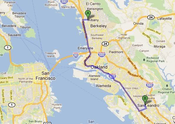
For SF, using 10,000+ as the threshold, Oakland and the East Bay really comes into play.

According to City-Data, there is a huge swath of connected neighborhoods with an average density of10,000ppsm+ extending all the way into San Leandro(3 neighborhoods connected to Oakland) and Albany(1 neighborhood connected to Berkeley) as well as about 2 dozen other Oakland neighborhoods that are connected to the former list of areas.

the area of 10,000+persons per square mile Extends over an area that is 18 Miles North to South from Downtown Albany to Farrelly Pond, San Leandro. Along this route:


Here is the updated list of Oakland, Berkeley, San Leandro and Albany connected neighborhoods with a density of 10,000+ppsm
Neighborhood, City, Population Per Square Mile
Oak Tree Neighborhood, Oakland 34,447
Gold Coast Neighborhood, Oakland 29,212
Telegraph Ave neighborhood, Berkeley 28,188
Adams Point Neighborhood, Oakland 26,632
Clinton Neighborhood, Oakland 25,677
Ivy Hill Neighborhood, Oakland 22,866
St Elizabeth Neighborhood, Oakland 21,327
Merritt Neighborhood, Oakland 19,957
Harrington Neighborhood, Oakland 19,951
Patten Neighborhood, Oakland 19,950
Highland Terrace Neighborhood, Oakland 18,625
Allendale Neighborhood, Oakland 18,880
Seminary Neighborhood, Oakland 17,899
Tuxedo Neighborhood, Oakland 17,502
Rancho San Antonio Neighborhood, Oakland 17,290
School Neighborhood, Oakland, CA 16,916
Hawthorne Neighborhood, Oakland 16,752
Meadow Brook Neighborhood, Oakland 16,772
Grand Lake Neighborhood, Oakland 16,716
Bella Vista Neighborhood, Oakland 16,713
Chinatown Neighborhood, Oakland 16,554
Southside Neighborhood, Berkeley 16,438
Fremont Neighborhood, Oakland 16,096
Oakland Ave/Harrison St Neighborhood, Oakland 15,980
Cox Neighborhood, Oakland 15,674
Hegenberger Neighborhood, Oakland 15,406
Fairfax Business Neighborhood, Oakland 15,242
Sausal Creek Neighborhood, Oakland 15,138
Peralta Hacienda Neighborhood, Oakland 14,811
Jefferson Neighborhood, Oakland 14,807
Wentworth-Holland Neighborhood, Oakland 14,794
Elmwood Neighborhood, Berkeley 14,603
Webster Neighborhood, Oakland 14,294
College Avenue Neighborhood, Berkeley 14,125
Eastmont Neighborhood, Oakland 14,002
Upper Peralta Creek Neighborhood, Oakland 13,959
East Peralta Neighborhood, Oakland 13,948
Highland Park Neighborhood, Oakland 13,705
Gourmet Ghetto Neighborhood, Berkeley 13,494
Castlemont Neighborhood, Oakland 13,414
Arroyo Viejo Neighborhood, Oakland 13,404
Cleveland Heights Neighborhood, Oakland 13,354
Fairfax Neighborhood, Oakland 12,993
Civic Center Neighborhood, Oakland, 12,856
North Neighborhood, Berkeley 12,815
Old Oakland Neighborhood, Oakland 12,280
Gaskill Neighborhood, Oakland 12,276
Iveywood Neighborhood, Oakland 12,136
Paradise Park neighborhood, Oakland 11,886
Piedmont Avenue Neighborhood, Oakland 11,798
South Berkeley neighborhood, Berkeley 11,749
Havenscourt Neighborhood, Oakland 11,639
North Stonehurst Neighborhood, Oakland 11,625
Farelly Pond Neighborhood, San Leandro 11,315
Central Berkeley Neighborhood, Berkeley 11,280
Fairview Park Neighborhood, Oakland 11,213
San Pablo Gateway Neighborhood, Oakland 11,151
Santa Fe Neighborhood, Oakland 11,132
Upper Laurel Neighborhood, Oakland 11,117
Laurel Neighborhood, Oakland 10,973
Longfellow Neighborhood, Oakland 10,896
Downtown Neighborhood, Albany 10,888
Las Palmas Neighborhood, Oakland 10,838
Bushrod Neighborhood, Oakland 10,810
Eastshore Neighborhood, San Leandro 10,738
Lakeshore Neighborhood, Oakland 10,736
Upper Dimond Neighborhood, Oakland 10,626
Creekside Neighborhood, San Leandro 10,393

Also, there is another large cluster a few miles North of the Oakland-Berkeley cluster of 10,000+ppsm in Richmond-San Pablo which includes the entire city of San Pablo and the entire Unincorporated town of Rollingwood

Richmond & San Pablo connected neighborhoods
Rollingwood CDP, 14,879 persons per square mile
Forest Park Neighborhood, Richmond 14,475 persons per square mile
City Center Neighborhood, Richmond 13,706 persons per square mile
Belding Woods Neighborhood, Richmond 13,273 persons per square mile
Eastshore Neighborhood, Richmond 11,710 persons per square mile
San Pablo City, 12,057 persons per square mile
Iron Triangle Neighborhood, Richmond 10,389 persons per square mile
Panhandle Annex Neighborhood, Richmond 10,299 persons per square mile

I made a map to satisfy my own curiosity.


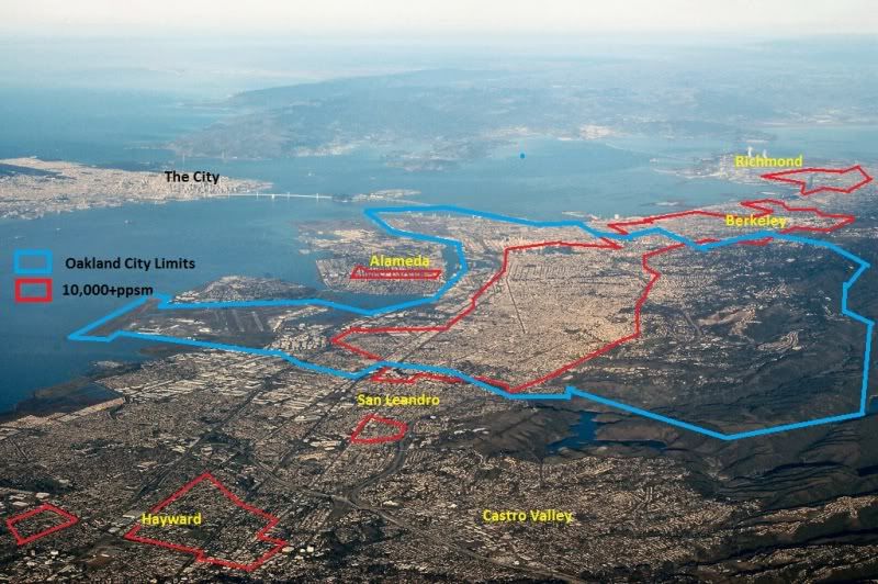
This also shows how dense the Bay Area is outside the cities of SF and Oakland.

That large red area of 10,000+ppsm in Hayward is 27 miles from the City.
Reply With Quote Quick reply to this message
 
Old 08-23-2011, 10:52 AM
 
Location: Center City
7,528 posts, read 10,252,903 times
Reputation: 11023
Quote:
Originally Posted by KodeBlue View Post
I've also noticed that Philly doesnt have the "big city" feel despite how populated, urban and dense it is. I thought it was just me that felt like that. Honestly, Philly doesnt feel any more like a big city than Baltimore, and i've been to philly on weekdays, weekends, summer, spring, fall...etc.
I have a very different perception. Outside the very buzzy and touristy Inner Harbor, Baltimore has a quite small downtown, and it's plagued with the remnants of "The Block." Like Philly and other cities, Baltimore is a city of neighborhoods, with some of Baltimore's more desirable areas stretching from Locust Point around the harbor to Canton. It's that stretching that wrecks it for me. While the harbor is of course an economic and aesthetic asset, it divides the city and makes it hard to traverse, and is future balkanized by large un-developed areas (e.g., between Locust Point and Federal Hill, Harbor East and Fells Point, and Fells Point and Canton). The challenge of getting from place to place is not made any easier by the city's fairly poor mass transit connections. Philly, on the other hand has a much larger and denser core and its vibrant neighborhoods are for the most part contingent and easily reachable by foot or PT. These were among the reasons we choose to Philly over Baltimore as our city for re-location.

Baltimore is a great city. I would not put it on the same tier as Philly however. Rather, I find it comparable to Kansas City, another under-recognzied gem that far too often flies under the radar.
Reply With Quote Quick reply to this message
 
Old 08-23-2011, 11:11 AM
 
Location: Philadelphia, PA
1,335 posts, read 1,661,088 times
Reputation: 344
I was in downtown Baltimore just a few weeks ago and indeed the CBD combined with the harbor feels quite large. If you walk both downtowns, Philly's size advantage becomes obvious. In a car, the straight grid in Philly lets you see the 'end' of downtown much more easily than in Boston, Baltimore, Atlanta, etc. but its an optical illusion. Center City itself looks smaller than it is. Consider City Hall, it's eight floors, each about 16ft high, look like just three floors from the outside.


cityhall with sig 12x16 (http://www.flickr.com/photos/imagicdigital/6008898413/ - broken link) by imagic digital (http://www.flickr.com/people/imagicdigital/ - broken link), on Flickr

Philadelphia City Hall - Wikipedia, the free encyclopedia

It's a behemoth, but by design it looks like it has three floors. Inside,

Quote:
Originally Posted by KodeBlue View Post
I've also noticed that Philly doesnt have the "big city" feel despite how populated, urban and dense it is. I thought it was just me that felt like that. Honestly, Philly doesnt feel any more like a big city than Baltimore, and i've been to philly on weekdays, weekends, summer, spring, fall...etc.
Reply With Quote Quick reply to this message
 
Old 08-23-2011, 11:17 AM
 
Location: Boston, MA
14,480 posts, read 11,276,052 times
Reputation: 8996
Quote:
Originally Posted by kidphilly View Post
I am surpirsed so many people feel Boston is larger than Philly and honestly even more surprised that you reference the CSA as feeling less spread, especially including PVD. PVD is like 30 some miles; within that distance you leave the CSA of Philly in the most populated area. Overall that just really surprises me. I wonder how many people base this perception on traversing the NJ turnpike from NYC; that image gives a strangly small perception of Philly and misses the urban footprint to a great extent.
Probably people who have never been there.

I'm a Bostonian who feels Philly is larger and more urban.
Reply With Quote Quick reply to this message
Please register to post and access all features of our very popular forum. It is free and quick. Over $68,000 in prizes has already been given out to active posters on our forum. Additional giveaways are planned.

Detailed information about all U.S. cities, counties, and zip codes on our site: City-data.com.


Reply
Please update this thread with any new information or opinions. This open thread is still read by thousands of people, so we encourage all additional points of view.

Quick Reply
Message:


Over $104,000 in prizes was already given out to active posters on our forum and additional giveaways are planned!

Go Back   City-Data Forum > U.S. Forums > General U.S. > City vs. City

All times are GMT -6.

© 2005-2024, Advameg, Inc. · Please obey Forum Rules · Terms of Use and Privacy Policy · Bug Bounty

City-Data.com - Contact Us - Archive 1, 2, 3, 4, 5, 6, 7, 8, 9, 10, 11, 12, 13, 14, 15, 16, 17, 18, 19, 20, 21, 22, 23, 24, 25, 26, 27, 28, 29, 30, 31, 32, 33, 34, 35, 36, 37 - Top