Please register to participate in our discussions with 2 million other members - it's free and quick! Some forums can only be seen by registered members. After you create your account, you'll be able to customize options and access all our 15,000 new posts/day with fewer ads.
The forecasters are darned if they do and darned if they don't. I can't begin to count how many times people have been wildly upset because a hurricane wasn't as bad as possibly predicted. Instead of being grateful, they are mad at the forecasters and the media for "fearmongering". They expect exact predictions of where, when and what intensity every time.
This happened very recently in CA, but people weren't listening either. All they heard was the word Hurricane, when for days forecasters said it would be a tropical storm when it reached San Diego. There were all sorts of comments about fear mongering, as if the tropical storm wasn't bad enough for some people. Others as far north as San Francisco thought their houses were going to be blown away when anyone who watched the forecast knew San Francisco might just get some rain if anything.
Well then you missed his update on Friday night. And I quote "Beneficial rain, we get stronger wind gusts from our regular afternoon thunder storms, nothing to worry about, a tropical storm". He's my go to in situations like this, but it appears he's being misled by the models.
I'm not blaming him, I'm suggesting that the models need to take into account unusually high SSTs which I don't think they're doing. They've been caught out by Idalia, Ian and Michael and possibly some others in recent times. Perhaps intensity shouldn't be forecast until 24 hours before landfall, I don't know the answer. Just an observation really.
After sitting through his PERSONAL LIVESTREAMS ON all SOCIAL MEDIA PLATFORMS, including Thurs 24th, Fri 25th I can state you're misquoting his reporting.
Thurs 8/24: He CLEARLY SAID "we can't tell you what's going to happen next Wednesday" and "we're going to go with what we DO know and in a few minutes we're getting the next update from the NHC - my guess is they'll probably bump it up higher and we'll go from there"
"THE CHALLENGE IS THIS STORM DOESN'T EXIST SO YOU WILL SEE A WIDE ARRAY OF SPAGHETTI MODELS"
Fri 8/25 INCLUDING 10 minutes of small talk including all about screening his GRAPHICS....
"it's clear people have no idea what goes into putting a forecast out for a hurricane"
THEN he goes into excruciating detail about that. All the while on the right of the screen projecting the ABC ACTION WEATHER graphics predicing a CYCLONE WITHIN 7 DAYS OF 80%.
Do you think he's IGNORING the predictions?
"A LITTLE CHANGE IN WHERE THE STORM IS MAKES A MASSIVE DIFFERENCE FOR THE MODELS".
Then he annouces he's going to go over EVERYTHING about preparing for hurricanes especially for "newbies" yada yada.
I can't even sit through an entire HOUR of his thorough excrutiating detail about this stuff because it's clear to me you didn't hear what you thought you heard.
This guys is long winded, overly enthusiastic about "change" and not cavalier if anything he's obscessed with HURRICANES.
This happened very recently in CA, but people weren't listening either. All they heard was the word Hurricane, when for days forecasters said it would be a tropical storm when it reached San Diego. There were all sorts of comments about fear mongering, as if the tropical storm wasn't bad enough for some people. Others as far north as San Francisco thought their houses were going to be blown away when anyone who watched the forecast knew San Francisco might just get some rain if anything.
Couldn't have had anything to do with Newsome grandstanding on Television trying to compete with DeSantis now could it?
After sitting through his PERSONAL LIVESTREAMS ON all SOCIAL MEDIA PLATFORMS, including Thurs 24th, Fri 25th I can state you're misquoting his reporting.
You have more patience than I. I apologize if I misquoted.
I took a look back at his TikTok (6 minutes at most, more my attention span.) on 8/24 - and "Could we have a tropical storm on the west coast of FL? Absolutely and that's what I think is going to happen. If it stays over water long enough and takes a track more over to the Big Bend area then there's a chance it becomes a minimal hurricane".
Now again, I'm not blaming him. I'm saying that whatever is predicting the intensity of these storms is not taking into account the recent records for rapid intensification and the record high SSTs.
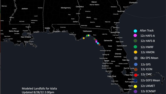
As I said yesterday, the outliers were pulling the cone track south with the center point being between Tampa and Cedar Key, but for the most part , the models had it coming in near Apalachicola, which is where the new models continue to center it.
On that one GEFS model note, here's some of the midday model runs I saw someone post, looks like 2 camps in the models...one group Steinhatchee to Cedar Key, other closer to Crawfordville to Apalachicola. Reading online this discrepancy may be due to the disorganized tilted center of Idalia so models are starting with slightly different starting points...makes a difference hundreds of miles down the road if you're starting point is slightly off at this angle of approach.
Note: these points can change again, this is just FYI on what they're saying midday Monday.
Please register to post and access all features of our very popular forum. It is free and quick. Over $68,000 in prizes has already been given out to active posters on our forum. Additional giveaways are planned.
Detailed information about all U.S. cities, counties, and zip codes on our site: City-data.com.

 Please register to participate in our discussions with 2 million other members - it's free and quick! Some forums can only be seen by registered members. After you create your account, you'll be able to customize options and access all our 15,000 new posts/day with fewer ads.


 I apologize if I misquoted.