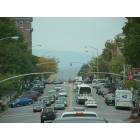
Vermonters hit hard by hurricane (Burlington, Barre: rent, mortgage, luxury)
Please register to participate in our discussions with 2 million other members - it's free and quick! Some forums can only be seen by registered members. After you create your account, you'll be able to customize options and access all our 15,000 new posts/day with fewer ads.
I dont know if I posted this yet - This is the page we are using to organize help efforts in the MRV...
Mad-River-Valley-Hurricane-Irene | Facebook (https://www.facebook.com/mrvpostirene - broken link)
He has posted - I can't remember which thread it was, but either yesterday or the day before...he put up a couple of photos/videos too if I'm not mistaken...
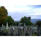
It's really strange out there. Some spots seem normal, others are like a war zone. Helicopters (military) flying overhead constantly, spots that look almost like a bomb dropped on them. I hiked into my favorite woods in Shrewsbury/Plymouth. In one place, one house's entire front yard washed away, exposing the foundation of the house and an old barn. Ran into a state forests and parks worker on an ATV out there surveying damage, but he was in quite a hurry. There are long stretches where it seems normal, and then there's this (for perspective, some of those washouts are 4 feet deep):
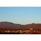
But the mountains are as beautiful as ever:
I'm also happy to report the wonderful stone house in the forest I love so much survived, probably only thanks to the trees holding up the hillside (out of battery power by that point in my camera though). I wish I could get down to the Somerset area but the Forest Service says the roads are basically gone, impassable for the most part, and they haven't even checked out everything yet. Forest Road 10 in Mount Tabor is also closed, quite bad, apparently. It goes into some very nice places like the Devil's Den...
Thanks for those photos, actichomesteader. They show the beauty and the tragedy of Vermont at the moment. I've heard a lot about this being a 100 year flood. Some say it was a 500-year flood. Many say it is the worst since 1927. Do any of you Vermont history buffs know the circumstances surrounding that weather event? Was it also caused by a hurricane/tropical storm, or was it during another time of year? Just wondering if any connection can be made between the two events.
On a personal note, I spoke to my daughter today. She lives in Chittenden County, and even though they didn't have catastropohic flooding in her town (although some areas were flooded, highway closed and under water) she said they were under a boil-water notice, so the effects are long-lasting and just keep coming.
The 1927 flood happened in the Fall and wasn't caused by a hurricane. October had heavy rain all month, which saturated the soil, but wasn't all at once so it didn't really cause flooding. Then in early November there was 36 hours or so of heavy, non-stop rain. Just under 10 inches in some places (the highest level being in Somerset IIRC). The soil couldn't hold more, the rivers were already swollen, and most of the state's land was cleared of trees so there was little to hold down the soil. I do believe if the land today was mostly cleared, and this happened in the Fall when we get a lot of rain, it would have been a much bigger disaster, beyond any doubt, than the 1927 flood. Vermont had problems since the 19th century with landslides and flooding up to the 1927 flood, all mostly stemming from clearing the land. Water coming down our hills and mountains can be a very destructive, powerful force.
thoughts and prayers to the green mountain state from texas...
My sentiments also. The video of the covered bridge in Vermont being flooded away was shown on some stations here in Texas. Amazing that I was in Vermont only 30 days ago.
As bad as it is in areas, remember that the news media feeds on making things look horrible so that their ratings go up. Much, if not most, of the state is not affected. Looking at the road maps, it is obvious that some areas were hit by more rain than others. Example - Barre and Montpelier normally would have flooded. Waterbury and Richmond did instead. Other than the Winooski being high (but still within banks until it reached its normal floodplain of the Intervale) the Burlington area was unaffected.
Stream washouts are part of the natural and continuous erosion process that creates valleys. We build roads alongside streams at our own risk.
Harry, living 30 miles away, I can attest to the devastation in southern VT. Daughter and family have been lugging food and supplies up mountain where people are cut off from everything. Unfortunately being in a flood plain had nothing to do with this as parts of mountains with houses were literally washed away. There are people who are stranded up the mountains with disabilities, people who only have the clothes on their back. The media isn't helping VT, believe me! 100 National Guard soldiers were sent to help them. The media is hyping NJ, where they ARE getting plenty of help.
Please register to post and access all features of our very popular forum. It is free and quick. Over $68,000 in prizes has already been given out to active posters on our forum. Additional giveaways are planned.
Detailed information about all U.S. cities, counties, and zip codes on our site: City-data.com.

 Please register to participate in our discussions with 2 million other members - it's free and quick! Some forums can only be seen by registered members. After you create your account, you'll be able to customize options and access all our 15,000 new posts/day with fewer ads.