Please register to participate in our discussions with 2 million other members - it's free and quick! Some forums can only be seen by registered members. After you create your account, you'll be able to customize options and access all our 15,000 new posts/day with fewer ads.
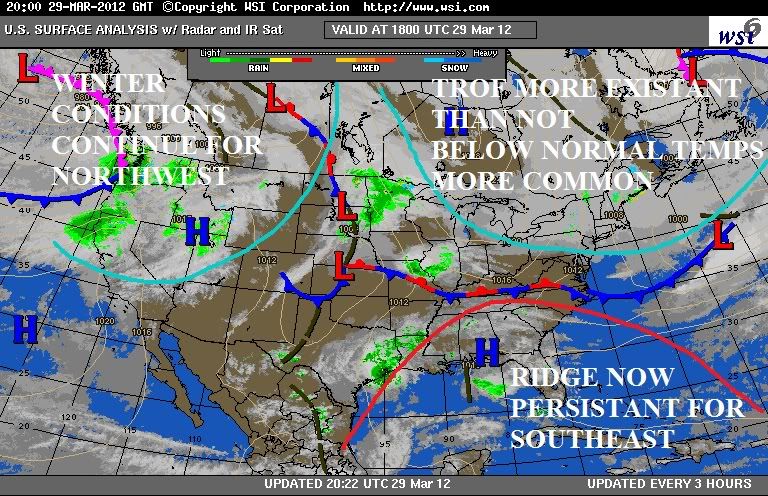
I'm seeing more signs of this happening from now on. Pattern has changed. Unfortunetly a December like pattern changed for April. Meaning cool temps(not teens) and snow flying around.
Moisture also making its way back into the picture again. Maybe signs El Nino is starting to come alive.
7.80 inches of precipitation for March here so far. Definitely the wettest March I've experienced here by far. The total could rise above 10 inches before the month ends...and the wettest months (nov,dec,jan) hardly ever reach 10 inches most years.
NWS Upton NY now has a change of heart. Lord help us. Why do they always do this? They have such a warm bias and have that "can never happen" attitude. Just strange.
?HIGH PRESSURE OVER THE REGION FRIDAY MORNING MOVES SOUTH AND EAST
DURING THE AFTERNOON AND OVERNIGHT. AS THIS HIGH MOVES AWAY FROM
THE REGION...A LOW PRESSURE SYSTEM TRACKING ACROSS THE OHIO VALLEY
WILL MOVE INTO THE MIDDLE ATLANTIC REGION.
THIS TRACK WILL PLACE THE TRI-STATE AREA ON THE NORTH SIDE OF THE LOW...IN WHAT WILL BE A COLD RAIN. AN EASTERLY FLOW OFF THE ATLANTIC SHOULD KEEP THE
BOUNDARY LAYER WARM FOR AN ALL RAIN EVENT...HOWEVER IF THE NEXT
MODEL RUNS COME IN SLIGHTLY COOLER...LATER SHIFTS MAY HAVE TO
INCLUDE SOME FROZEN PRECIPITATION LATE FRIDAY NIGHT IN THE
FORECAST"
Upper 70s and low 80s for highs until a cold front comes through on Sunday night. Knocks us back to upper 50s, but mid 30s for lows. No chance for snow, at least for now. Good thing is 30 minutes east about an inch of snow and lows in the single digits. I think I'll go there
NWS Upton NY now has a change of heart. Lord help us. Why do they always do this? They have such a warm bias and have that "can never happen" attitude. Just strange.
?HIGH PRESSURE OVER THE REGION FRIDAY MORNING MOVES SOUTH AND EAST
DURING THE AFTERNOON AND OVERNIGHT. AS THIS HIGH MOVES AWAY FROM
THE REGION...A LOW PRESSURE SYSTEM TRACKING ACROSS THE OHIO VALLEY
WILL MOVE INTO THE MIDDLE ATLANTIC REGION.
THIS TRACK WILL PLACE THE TRI-STATE AREA ON THE NORTH SIDE OF THE LOW...IN WHAT WILL BE A COLD RAIN. AN EASTERLY FLOW OFF THE ATLANTIC SHOULD KEEP THE
BOUNDARY LAYER WARM FOR AN ALL RAIN EVENT...HOWEVER IF THE NEXT MODEL RUNS COME IN SLIGHTLY COOLER...LATER SHIFTS MAY HAVE TO INCLUDE SOME FROZEN PRECIPITATION LATE FRIDAY NIGHT IN THE FORECAST"
Best to be conservative, especially considering the time of year.
Best to be conservative, especially considering the time of year.
I would agree with that, only that they do it in dead of winter too, so the statement doesnt ring true for them. lol
The best was on January 21st this year they issued out a Snowstorm Warning...AFTER 4" fell and the back edge was 2 hours away. LOL! That was great.
Or when they show 2-4" to fall meanwhile models showing 6-8". Then 6 hours before they up it to 5-7". They always have the "nothing will happen" approach and unfortunetly that doesnt help save lives or prepare people..
Once this winter the short-term forecast said "no significant accumulation" while we were getting two feet! Apparently that used to happen more often, but the models have improved. Now they're usually within 6 inches or so, which is close enough.
Wow, apparently they could be snow all the way down to northern NJ!
If this was February then I wouldn't mind, but it's almost April and it shouldn't be snowing, especially after all that warm weather. If it stayed cool all month then I wouldn't mind, but if it does snow then it's going to ruin any crops that have been planted.
If this was February then I wouldn't mind, but it's almost April and it shouldn't be snowing, especially after all that warm weather. If it stayed cool all month then I wouldn't mind, but if it does snow then it's going to ruin any crops that have been planted.
Bring it on, I say. Any improvement in weather is welcome by me . As for crops it's their mistake for planting crops this early, and even if it wasn't I am not a plant and would not be willing to suffer through a 7-month summer just because plants are growing too early. I'd welcome a correction (such as all the leaves turning black and falling off; revenge would be sweet in this case ).
Massive change in the weather today, to more seasonal weather.
Currently 7°C / 45°F and overcast at 11:15AM, compared with 16°C and sunny yesterday.
I shall be taking out the customary roll of loo-roll to town with me as usual in cold weather as my nose runs badly when it's cold (one of the many hundreds of things I hate about the cold).
Last edited by Weatherfan2; 03-30-2012 at 04:25 AM..
Please register to post and access all features of our very popular forum. It is free and quick. Over $68,000 in prizes has already been given out to active posters on our forum. Additional giveaways are planned.
Detailed information about all U.S. cities, counties, and zip codes on our site: City-data.com.

 Please register to participate in our discussions with 2 million other members - it's free and quick! Some forums can only be seen by registered members. After you create your account, you'll be able to customize options and access all our 15,000 new posts/day with fewer ads.


 . As for crops it's their mistake for planting crops this early, and even if it wasn't I am not a plant and would not be willing to suffer through a 7-month summer just because plants are growing too early. I'd welcome a correction (such as all the leaves turning black and falling off; revenge would be sweet in this case
 ") ).
).
