Please register to participate in our discussions with 2 million other members - it's free and quick! Some forums can only be seen by registered members. After you create your account, you'll be able to customize options and access all our 15,000 new posts/day with fewer ads.
Winter Storm Watch criteria for Buffalo is 7" in 12 hrs or 9" in 24hrs. They are saying they have better confidence for localized Advisory criteria off Lake Ontario. Does that mean up to half foot is possible?
THE WELL ADVERTISED TRANSITION TO A MORE WINTRY WEATHER REGIME
CONTINUES ON TRACK FOR THE REMAINDER OF THE PERIOD. WE GENERALLY
FOLLOWED ALONG WITH THE NCEP PREFERRED BLEND OF THE 12Z GFS AND
ECMWF WHICH SUGGESTS A SLOWER AND MORE AMPLIFIED SOLUTION WITH
THE NORTHERN PLAINS SHORTWAVE AND THE ASSOCIATED SHARP COLD FRONTAL
BOUNDARY...THAN THE MORE PROGRESSIVE NAM OR CANADIAN. THE COLD FRONT
WILL PASS THROUGH THE AREA DURING THE DAYTIME HOURS FRIDAY WITH A
BAND OF AT LEAST SCATTERED SHOWER ACTIVITY DEVELOPING ALONG IT. A
DRY SLOT BEHIND THE FRONT WILL TEMPORARILY END THE SHOWERS BY MID
TO LATE AFTERNOON. MAIN UPPER WAVE AND SECONDARY COLD FRONT WILL
CROSS THE AREA FRIDAY NIGHT. IT IS BEHIND THIS BOUNDARY WHEN THE
REAL SURGE OF COLD AIR TAKES PLACE WITH 850 MB TEMPERATURES
PLUNGING TO NEAR -12C BY SATURDAY MORNING.
FAVORABLE THERMODYNAMIC PROFILES LOOK TO BE IN PLACE TO GET LAKE
EFFECT SNOWS SET UP ON AN INITIAL WEST NORTHWEST FLOW
REGIME...BEFORE THE FLOW VEERS MORE NORTHWESTERLY AS WE GET INTO
SATURDAY NIGHT. MODEL SOUNDINGS SHOWING EXCELLENT DELTA T VALUES AS
850 MB TEMPERATURES REMAIN AROUND -12C INTO SATURDAY NIGHT...LAKE
INDUCED CAPES EXCEEDING 750 J/KG...AS WELL AS LAKE EQUILIBRIUM
LEVELS OVER 10K FEET. IN ADDITION...SOME MODEL SUGGESTING OF
UPSTREAM LAKE CONNECTIONS DEVELOPING WHICH COULD BRING LOCALIZED
ENHANCED SNOWFALL.
PATTERN RECOGNITION WOULD SUPPORT SEVERAL INCHES
OF ACCUMULATION OFF LAKE ERIE ALONG THE CHAUTAUQUA RIDGE...WITH SOME
BETTER CONFIDENCE FOR LOCALIZED ADVISORY CRITERIA SNOWS OFF LAKE
ONTARIO...THE SUGGESTION OF A MORE BACKED LOW LEVEL FLOW WOULD
SUPPORT THE POTENTIAL FOR SEVERAL INCHES OF SNOW HERE AS WELL...FROM
THE SOUTHERN TUG HILL OVER TO AREAS JUST EAST OF ROCHESTER. MUCH TOO
EARLY FOR ANY TYPE OF WINTER WEATHER HEADLINES...SO WILL CONTINUE TO
MENTION ON THE HAZARDOUS WEATHER OUTLOOK AS A MEANS OF EXPRESSING
THE POTENTIAL IMPACTS FROM THIS EVENT.
THIS WILL CERTAINLY BE A MUCH COLDER PERIOD AFTER A PERIOD OF RATHER
MILD WEATHER...WITH TEMPERATURES BY EARLY FRIDAY EVENING LIKELY
FALLING INTO THE UPPER 30S. HIGHS ON SATURDAY IN THE 30S...WITH
BRISK WINDS CREATING WINDS CHILLS IN THE TEENS AND 20S
If you're like me today you would of been wondering why we have North winds in November but temps are warming up into the 50s. This is very cool to see!
Apparently there is Pacific Flow from the West & a Ridge in the center part of the country pumping warm air "up" from the south, Not North......
So how is the warm air getting to the east if the winds are from the North??
Well, the warm air is sloping down the mountains into the East. I added some OBS at bottom right to see. Usually North winds would mean cooler air is coming into us....Not the case today
Pretty cool huh.
Being on the lee side of the mountains, we get this chinook effect all the time. It's a very descriptive native american term that means "snow eater". We can get some impressive snows out here, but with the warmer air and chinook winds from the west, they tend to be more of a victim of evaporation than actual melting. Temperatures can rise 50+ degrees in just a couple of hours with the right conditions.
Thats the way it always is. The rarest of phenomenoms occur when least expected, it snowed in South-West England and lay, we still haven't seen lying snow cover.
Funny thing is, areas that always have to wait the longest always seem to get the best of the best.
I remember in the 2010 cold spell all of the snow was concentrated at the start in NE England, but by the end it was here and we had tempertaures of -19c meanwhile it was much warmer in NE England. Sometimes, its best to wait.
As Im watching the crazy run of the GFS just out which gives Vermont 6-10" of snow next week and light snow to the coast... Here's what Mammoth Mountain in California just said... //www.facebook.com/MammothMTN?ref=stream
"The storm has cleared and the snowfall totals are in. Mammoth Mountain picked up two feet of fresh snow at Main Lodge and considerably more at the top of the mountain. However, snow levels stayed high, so Canyon and Eagle Lodges did not get the snow necessary to open for the Thanksgiving weekend. This image shows just how much terrain we will have open by the holiday. The most snow, most terrain and best conditions in California are at Mammoth this Thanksgiving!"
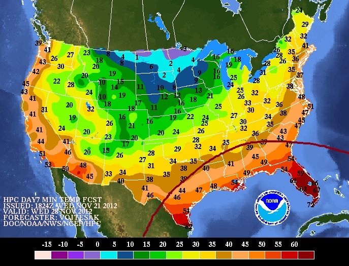
HPC minimum temps for November 28th. I dont know... more and more I'm noticing a squashed SouthEast ridge and the Northern jet engulfing more of the Nation. I wonder if this will be the new look of the Winter coming up where there's no true Ridge in place aside from extreme SouthEast.
Highs are only forecasted to about 5 F above average tomorrow and Friday. Then highs will be 5-10 F below average before creeping back up to about average as we wrap up November. Perhaps we'll finally have a below average month here.
I see they have issued a Winter Storm Watch for some counties in the U.P. north of us here in Michigan. Still saying Friday evening the winds will get locked in on a NW flow and they are waiting to push the Warning button for the Lake Effect snow to begin hammering us. Tomorrow should be close enough to the target time for when it begins for them to finally advise how much snow will occur. They've already mentioned our little town as one of the places in the path of the heaviest snow fall. Maybe this winter will be more normal and we can finally see some decent snow. Just need to get the plow guy lined up and show him where we want it pushed to when the time comes. I want to get back to the good ol days when 200" plus is normal for the season.
Heads up. Thanksgiving Night through Friday. Snowy December coming up.
Michigan here.
935 PM EST WED NOV 21 2012
...WINTER STORM WATCH REMAINS IN EFFECT FROM LATE THURSDAY NIGHT
THROUGH LATE FRIDAY NIGHT...
HAZARDOUS WEATHER...
* MODERATE TO HEAVY SNOW IS POSSIBLE LATE THURSDAY NIGHT INTO FRIDAY NIGHT. AT THIS TIME...THE HEAVIEST SNOW IS EXPECTED TO FALL
FROM FRIDAY MORNING THROUGH LATE FRIDAY EVENING OVER MUCH OF
CENTRAL AND EASTERN ALGER...NORTHERN SCHOOLCRAFT AND NORTHERN LUCE
COUNTIES.
* STORM TOTAL SNOWFALL AMOUNTS MAY BE IN EXCESS OF 6 INCHES.
* STRONG WIND GUSTS UP TO 45 MPH ARE POSSIBLE NEAR LAKE SUPERIOR... WITH GUSTS UP TO 30 MPH INLAND.
IMPACTS...
* ROADS MAY BECOME SNOW COVERED QUICKLY LATE THURSDAY NIGHT INTO
FRIDAY MORNING...MAKING TRAVEL HAZARDOUS.
* GUSTY WINDS MAY CAUSE BLOWING SNOW AND REDUCED VISIBILITIES...AS
WELL AS DROPPING WIND CHILL VALUES INTO THE TEENS.
PRECAUTIONARY/PREPAREDNESS ACTIONS...
* A WINTER STORM WATCH MEANS THERE IS A POTENTIAL FOR SIGNIFICANT
SNOW THAT MAY IMPACT TRAVEL
Please register to post and access all features of our very popular forum. It is free and quick. Over $68,000 in prizes has already been given out to active posters on our forum. Additional giveaways are planned.
Detailed information about all U.S. cities, counties, and zip codes on our site: City-data.com.

 Please register to participate in our discussions with 2 million other members - it's free and quick! Some forums can only be seen by registered members. After you create your account, you'll be able to customize options and access all our 15,000 new posts/day with fewer ads.