Please register to participate in our discussions with 2 million other members - it's free and quick! Some forums can only be seen by registered members. After you create your account, you'll be able to customize options and access all our 15,000 new posts/day with fewer ads.
I figured after looking at the radar. Its light stuff and temps should warm up soon. Layer above is warm and some surface has dropped to freezing. Ice in parts of CT as well.
Upton NY "We can expect periods of unsettled weather through the coming week, thanks to a series of storm systems poised to affect the area. Satellite imagery gives us a good look at the culprits! Systems 1 and 2 are helping to create the wet weather we're currently seeing. Systems 3 and 4 will combine to produce gusty winds and rain late Monday into Tuesday. And way out in the Pacific is an upper-level system (5) that will likely help bring another round of precip and wind late Thursday into Friday. Make sure to check NOAA National Weather Service for the latest information!"
I clicked on the link and saw its 00hr initialization of snow depth from the GFS model. Its gridds of course are pretty big and thus smooths over things too much....and in doing so that leads to higher amounts. Yes the far northern areas of ND have 6-7 in on the ground and the far south part of ND into nrn SD got around 6 as well...but in between as the actual data shows not much closer to 1. But the initialized model 00 hr has a general 4-6 over the whole state of ND into northwest MN....and thus starts off too high.
Might get an inch in spots from Tues system....but these types dont tend to produce much.
Interesting....but again it is model initialized....so with the current gridd spacing it will tend to smooth things out too much.
Oh ok....yeah the snow depth one isnt all that valuable....I dont know where it has the 6-8 in eastern ND thru nrn MN....we got around 1-2 inches presently except right along the border and if we get an inch (which is generous) still off a bit. So advise to use with caution.
After I posted I did see SnowD in the upper left.
That was an AWIPS screen capture.... we dont have any fancy computer PC programs to pull AWIPS images into the PC....that is the best we have.
Dan
Got an answer.. Feel free to contact them and let us know. Those graphics are based on the individual runs of the GFS so they are as accurate as the model shows.
Quote:
"The Snow Depth field comes from the GFS model. You'll have to contact the NOAA Numerical Modeling folks for information on how it's calculated.
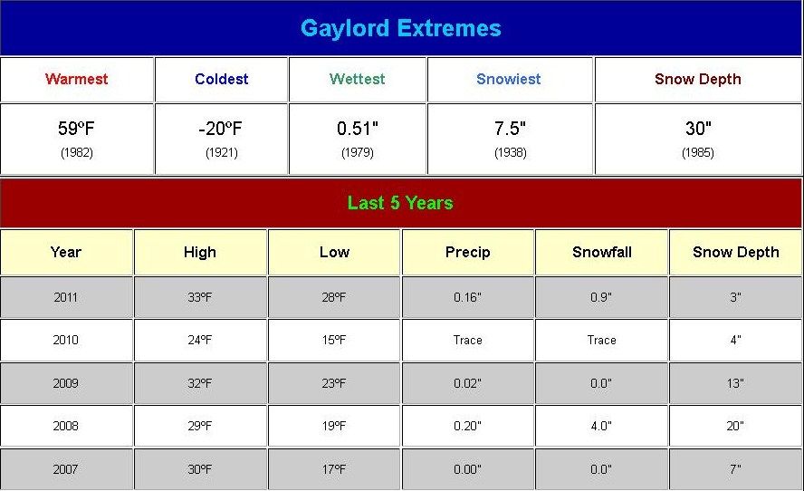
Our local NWS supplied a link on their Facebook page regarding the extremes for the past 100 yrs weather on Christmas Day. I am listing the closest city they had which is about 25 miles from me.
Layer of glaze but some rain didn't freeze. My driveway has puddles and not much ice. Handrail to the steps of my front door has ice but the steps seemed fine. Could go for a midnight stroll to see how much stuck but that's probably stupid.
Please register to post and access all features of our very popular forum. It is free and quick. Over $68,000 in prizes has already been given out to active posters on our forum. Additional giveaways are planned.
Detailed information about all U.S. cities, counties, and zip codes on our site: City-data.com.

 Please register to participate in our discussions with 2 million other members - it's free and quick! Some forums can only be seen by registered members. After you create your account, you'll be able to customize options and access all our 15,000 new posts/day with fewer ads.