Please register to participate in our discussions with 2 million other members - it's free and quick! Some forums can only be seen by registered members. After you create your account, you'll be able to customize options and access all our 15,000 new posts/day with fewer ads.
Oh right, I got 12cm, not much of a difference. It's because 12cm was reported for the 1st of February but when I clicked on that date, the snow depth was reported at 05:39am that day and most of the snow started from the day before which was January
I know your snowfall totals are almost always less than ours, but 40-50 cm for an entire year is very little snow. At least to Canadians it is.
Vancouver and Victoria are considered generally "snow-free" in Canada and they average just under 40 cm a year.
Toronto is considered by most in Canada to be a fairly "low snow" city and is in the 120-140 cm range for an average.
^ Lots of places in Canada average under 100 cm. Just not a lot in Qwebeck. The only place in your province with under 100 cm is St Francois with 98 cm. 23% of all weather stations average under 100 cm, and 6% of all weather stations average less than 50 cm. Some average as low as 10 cm.
Some years places go the entire year without snow. This was the case in 2013, but not 2014. The least snowy place in Canada in 2014 was Langara, BC with 18.4 cm. The snowiest place in the country, also in BC, had 897 cm on Mount Fidelity near Revelstoke. The wettest place in Canada, Boat Bluff, BC, had 4.735 meters of precipitation. Kamloops was the driest place with 289 mm. The north was likely drier, but EC sucks to the point that all weather stations in the north glitched, and thus have missing data from 2014.
The hottest place in Canada was Ashcroft, BC with 41.7C (107F), and the place with the highest mean in Canada was Sisters Island, BC with an average temperature of 11.9. 2014 was the 11th warmest year on record in BC.
The coldest spot in Canada was Eureka, Nunavut with a -50.2C. This is the first time in recorded history that Eureka has been Canada's cold spot two years in a row. Even though it has the coldest average temperature in Canada, it has only ever been the extreme cold spot 3 other times besides the past two years. The Yukon is slipping.
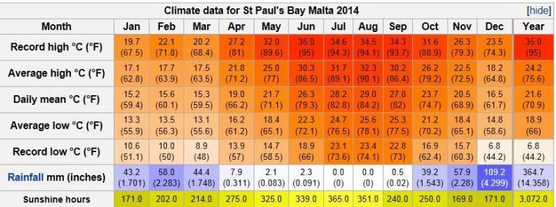
My weather station in St Paul's Bay (northern coast) along with those from the Malta Met Office station at Luqa Airport (inland southern part of Island)...
Very mild year for Serres. Winter months January, February and December were above average. Summer was normal. Precipitation was above average. I am waiting the sunshine for November and December from our national service.
If to talk some more about the temperatures of 2014 here one can notice that the biggest positive anomaly in 2014 occured certainly in February and March.the February in my nearest station was 5.4c warmer than average and March 4.2c. I monitored my neighbours as well and occures that the same phenomenon was for instance seen in Moscow where also February and March were the months which had the highest positive anomalies (about as big as here).
<However, it occures still that July average here was a bit higher than in Trondheim. Still we in turn got a bit lower average july temperature than Oslo and Turku.
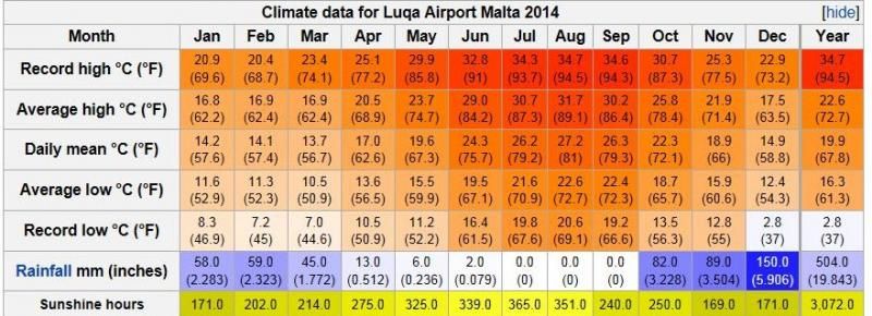
My weather station in St Paul's Bay (northern coast) along with those from the Malta Met Office station at Luqa Airport (inland southern part of Island)...
Trodheim (Værnes)
Days with lows below 0c in 2014: 88 days
Dec: 19 days
Nov: 15
Oct: 4
May: 2
April:6
March: 10
Feb: 8
January: 24
Ice-days (high below 0c): 24. 17 of those was in January.
Norway: Largest deviation from the normal in 2014 was February at Svalbard. In Longyearbyen, February mean was 14.5c warmer than the normal.
On the mainland, temperatures in Finnmark province was 10c above normal in February.
Norway: Largest deviation from the normal in 2014 was February at Svalbard. In Longyearbyen, February mean was 14.5c warmer than the normal.
On the mainland, temperatures in Finnmark province was 10c above normal in February.
oh, i knew the norhernmost areas might had the largest deviations but i did not know they were that large.14.5 c above normal -that is amazing
Do you have any wieldy data, were there any months in Longyearbyen not above average in 2014 and how were deviations there in 2013?
annual average temperature, precipitation and sunshine hours for a few cities 2014.
extreme stats for 2014.
Highest temperature: 35.1 degrees in Falun-Lugnet, Dalarna August 4th.
Lowest temperature: -42.7 degrees in Karesuando, Lapland on 20 January.
Highest average annual temperature: 10.5 degrees in Falsterbo automatic station, Skane.
The lowest annual mean temperature: -1.0 degree in Naimakka, Lapland.
The greatest annual precipitation: 1385 mm Mollsjönäs, Västergötland.
Minimum annual rainfall: 282 mm Pite-Rönnskär, Västerbotten.
The greatest precipitation: 134 mm in Hallum, Västergötland August 19.
The largest measured snow depth: 159 cm Katterjåkk, Lapland, on 5 April.
Most of sunshine: 2193 hours in Swedish Högarna in the northern Baltic Sea, Södermanland.
Minimum hours of sunshine: 1107 hours in Tarfala, Lapland.
Highest average wind on the coast: 27 m / s in Hano, Blekinge on 12 December.
Highest mean wind in the mountains: 38 m / s in Stora sjöfallet, Lapland on 8 March.
Highest wind gusts in the interior: 29 m / s Rynge, Scania on March 15th.
Please register to post and access all features of our very popular forum. It is free and quick. Over $68,000 in prizes has already been given out to active posters on our forum. Additional giveaways are planned.
Detailed information about all U.S. cities, counties, and zip codes on our site: City-data.com.

 Please register to participate in our discussions with 2 million other members - it's free and quick! Some forums can only be seen by registered members. After you create your account, you'll be able to customize options and access all our 15,000 new posts/day with fewer ads.


 Haha
Haha 


