Please register to participate in our discussions with 2 million other members - it's free and quick! Some forums can only be seen by registered members. After you create your account, you'll be able to customize options and access all our 15,000 new posts/day with fewer ads.
High today 88F here and 89F at both Chicago airports. Much cooler tomorrow...
Quote:
Originally Posted by baltasar64
I think the Canadian warming world is no bigger than the one that will generate the heat in Greece.
Don’t you think that there is no other city in the western world that is not in the desert that is not warmer than Athens during hot waves? The forecasts for Athens are very impressive.
In terms of capital cities that aren't deserts Athens is probably the hottest in the western world during heat waves but there are many cities in the US that are not deserts and are much hotter. Dallas Houston New Orleans for example. Even further north like Oklahoma City and the heat waves here in the Midwest from the 1930s are worse than what Athens has seen and at a latitude much further north. Chicago had a similar heatwave in 1934 and we are at the same latitude as Rome
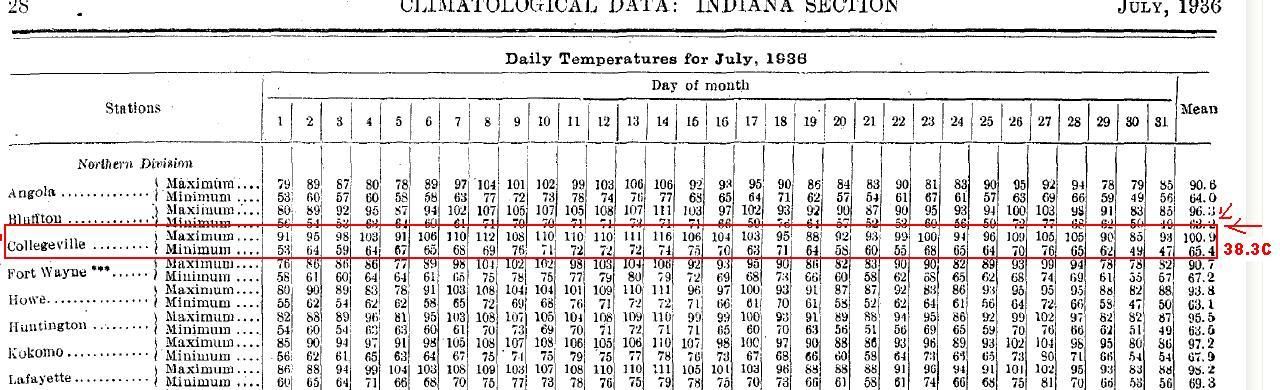
And in 1936 50 miles southeast of Chicago Collegeville Indiana had a record 116F/47C and an average high for the entire month of 38.3C
Not to mention the Dakotas which were much worse in the 1930s.
Last edited by chicagogeorge; 07-29-2021 at 04:14 PM..
105f 52f dew today
Crazy, humid heat needs to go away.
It's all Arizona's fault for giving us this crap.
Only good thing I've noticed is that evening are cooling down faster. Should have decent evenings and mornings in 2-3 weeks, even during heatwaves.
Can't come soon enough.
Edit: it doesn't affect me, but I'm glad to see cornsweat back in the news
With two days left of the in the month, July will end up about -1.5F below normal in the Means and about -2.5F below normal in average high temps. August will open cool but Skilling says above normal temps are a week away.
Another 1.54" fell yesterday bringing my monthly total to 10.98"!
Hoping for a drizzle today or tomorrow to bring me to 11"!
Here's the rain from yesterday. The inner tube holds 1" then spills into the outer tube which can hold up to 10 inches. You pour the precip from inner tube out, then pour the water from the outer tube into the inner tube with the funnel to measure whats in the outer tube. Not rocket science.
With two days left of the in the month, July will end up about -1.5F below normal in the Means and about -2.5F below normal in average high temps. August will open cool but Skilling says above normal temps are a week away.
So we had our 2nd hottest June, 1st hottest July, and will be getting a top 5 hottest August.
R u kidding me
I don't even know what to say.
Goodbye, cg
Finally a break from the heat and humidity, though I know our heat in Indianapolis has been nothing like other places have been experiencing. Amazingly we only hit 90F once this entire month of July, which brings our total number of 90+ days this year to 6. We usually average around 18 days of 90 or higher each year. Granted, we can still definitely hit 90 in August and September. Looking back over July to this point, it's been very normal as far as temperature goes. We're 0.7F below normal but if you look over individual days, only a handful at the beginning of the month for between 5-10 degrees below average. Every other day has been within 5 degrees of average. And even though we're more than 2 inches above normal for precipitation, we haven't seen measurable rain in 2 weeks. Still, after a week of upper 80s with dewpoints in the 70s, it will be nice to have highs in the 70s and dewpoints in the 50s for a while.
Please register to post and access all features of our very popular forum. It is free and quick. Over $68,000 in prizes has already been given out to active posters on our forum. Additional giveaways are planned.
Detailed information about all U.S. cities, counties, and zip codes on our site: City-data.com.

 Please register to participate in our discussions with 2 million other members - it's free and quick! Some forums can only be seen by registered members. After you create your account, you'll be able to customize options and access all our 15,000 new posts/day with fewer ads.