Brittons Neck, South Carolina
Submit your own pictures of this place and show them to the world
- OSM Map
- General Map
- Google Map
- MSN Map

| Males: 1,227 | |
| Females: 1,209 |
| Median resident age: | 34.0 years |
| South Carolina median age: | 35.4 years |
Zip code: 29546
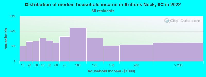
| Brittons Neck: | $39,764 |
| SC: | $64,115 |
Estimated per capita income in 2022: $21,418 (it was $13,318 in 2000)
Brittons Neck CCD income, earnings, and wages data
Estimated median house or condo value in 2022: $85,970 (it was $45,000 in 2000)
| Brittons Neck: | $85,970 |
| SC: | $254,600 |
Detailed information about poverty and poor residents in Brittons Neck, SC


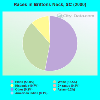
- 1,34453.0%Black alone
- 90135.5%White alone
- 27210.7%Hispanic
- 70.3%Two or more races
- 40.2%Asian alone
- 50.2%Other race alone
- 30.1%American Indian alone
- 10.04%Native Hawaiian and Other
Pacific Islander alone
Races in Brittons Neck detailed stats: ancestries, foreign born residents, place of birth
 Recent articles from our blog. Our writers, many of them Ph.D. graduates or candidates, create easy-to-read articles on a wide variety of topics.

Current Local Time: EST time zone
Elevation: 36 feet
Land area: 108.7 square miles.
Population density: 22 people per square mile (very low).

| Brittons Neck CCD: | 0.4% ($199) |
| South Carolina: | 0.6% ($510) |
Nearest city with pop. 50,000+: North Charleston, SC  (79.3 miles , pop. 79,641).
Nearest city with pop. 200,000+: Charlotte, NC (125.4 miles , pop. 540,828).
Nearest city with pop. 1,000,000+: Philadelphia, PA (482.3 miles , pop. 1,517,550).
Nearest cities:
), ), ), ), ), Latitude: 33.88 N, Longitude: 79.33 W
Area code commonly used in this area: 843

| Here: | 4.5% |
| South Carolina: | 3.1% |
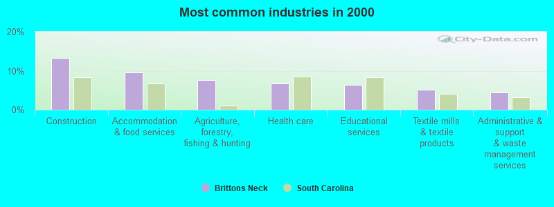
- Construction (13.2%)
- Accommodation & food services (9.5%)
- Agriculture, forestry, fishing & hunting (7.6%)
- Health care (6.7%)
- Educational services (6.4%)
- Textile mills & textile products (5.1%)
- Administrative & support & waste management services (4.4%)
- Construction (22.2%)
- Agriculture, forestry, fishing & hunting (12.5%)
- Administrative & support & waste management services (6.8%)
- Accommodation & food services (5.8%)
- Textile mills & textile products (5.5%)
- Truck transportation (4.4%)
- Arts, entertainment, recreation (4.4%)
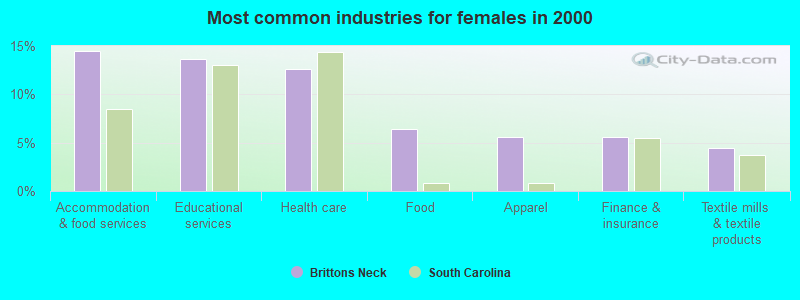
- Accommodation & food services (14.5%)
- Educational services (13.7%)
- Health care (12.6%)
- Food (6.4%)
- Apparel (5.6%)
- Finance & insurance (5.6%)
- Textile mills & textile products (4.5%)
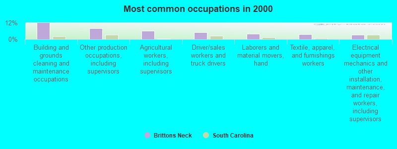
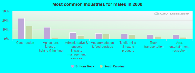
- Building and grounds cleaning and maintenance occupations (11.9%)
- Other production occupations, including supervisors (8.1%)
- Agricultural workers, including supervisors (6.3%)
- Driver/sales workers and truck drivers (5.0%)
- Laborers and material movers, hand (3.9%)
- Textile, apparel, and furnishings workers (3.7%)
- Electrical equipment mechanics and other installation, maintenance, and repair workers, including supervisors (3.3%)
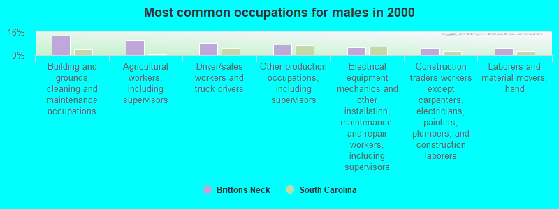
- Building and grounds cleaning and maintenance occupations (13.7%)
- Agricultural workers, including supervisors (10.3%)
- Driver/sales workers and truck drivers (8.4%)
- Other production occupations, including supervisors (7.3%)
- Electrical equipment mechanics and other installation, maintenance, and repair workers, including supervisors (5.2%)
- Construction traders workers except carpenters, electricians, painters, plumbers, and construction laborers (4.9%)
- Laborers and material movers, hand (4.7%)
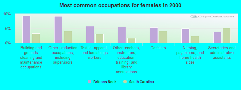
- Building and grounds cleaning and maintenance occupations (9.4%)
- Other production occupations, including supervisors (9.2%)
- Textile, apparel, and furnishings workers (5.8%)
- Other teachers, instructors, education, training, and library occupations (5.6%)
- Cashiers (5.3%)
- Nursing, psychiatric, and home health aides (4.9%)
- Secretaries and administrative assistants (3.8%)
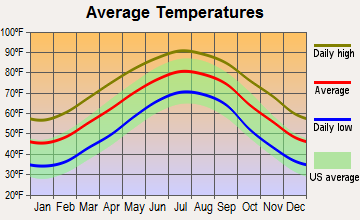
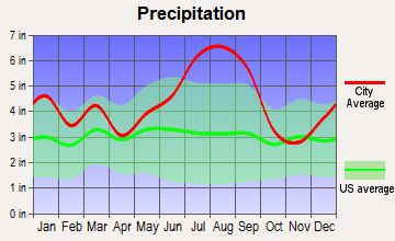
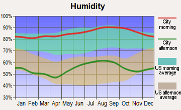
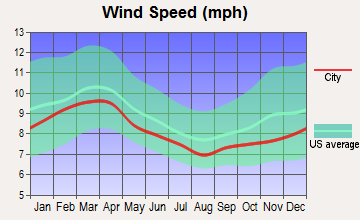
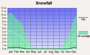
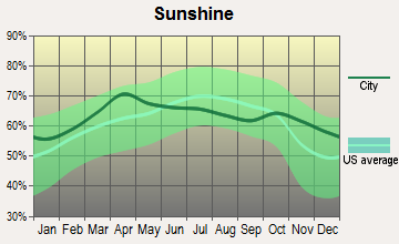
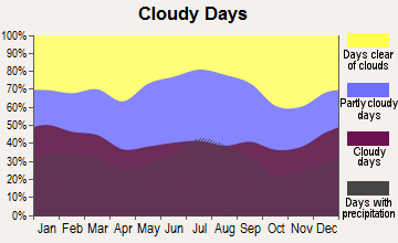
Average climate in Brittons Neck, South Carolina
Based on data reported by over 4,000 weather stations
Tornado activity:
Brittons Neck-area historical tornado activity is slightly below South Carolina state average. It is 9% smaller than the overall U.S. average.
On 11/7/1995, a category F4 (max. wind speeds 207-260 mph) tornado 14.2 miles away from the Brittons Neck place center injured one person and caused between $500,000 and $5,000,000 in damages.
On 11/24/1967, a category F3 (max. wind speeds 158-206 mph) tornado 7.3 miles away from the place center injured one person and caused between $5000 and $50,000 in damages.
Earthquake activity:
Brittons Neck-area historical earthquake activity is significantly above South Carolina state average. It is 51% smaller than the overall U.S. average.On 8/23/2011 at 17:51:04, a magnitude 5.8 (5.8 MW, Depth: 3.7 mi, Class: Moderate, Intensity: VI - VII) earthquake occurred 289.6 miles away from the city center
On 11/22/1974 at 05:25:55, a magnitude 4.7 (4.7 MB, Class: Light, Intensity: IV - V) earthquake occurred 82.4 miles away from Brittons Neck center
On 8/9/2020 at 12:07:37, a magnitude 5.1 (5.1 MW, Depth: 4.7 mi) earthquake occurred 205.4 miles away from the city center
On 8/21/1992 at 16:31:55, a magnitude 4.4 (4.1 MB, 4.1 LG, 4.4 LG, Depth: 6.2 mi) earthquake occurred 73.0 miles away from Brittons Neck center
On 8/2/1974 at 08:52:09, a magnitude 4.9 (4.3 MB, 4.9 LG) earthquake occurred 181.2 miles away from Brittons Neck center
On 4/17/1995 at 13:45:57, a magnitude 3.9 (3.9 LG, Depth: 6.2 mi, Class: Light, Intensity: II - III) earthquake occurred 77.2 miles away from Brittons Neck center
Magnitude types: regional Lg-wave magnitude (LG), body-wave magnitude (MB), moment magnitude (MW)
Natural disasters:
The number of natural disasters in Marion County (18) is near the US average (15).Major Disasters (Presidential) Declared: 9
Emergencies Declared: 5
Causes of natural disasters: Hurricanes: 10, Winter Storms: 3, Floods: 2, Storms: 2, Ice Storm: 1, Tropical Storm: 1, Other: 1 (Note: some incidents may be assigned to more than one category).
Colleges/universities with over 2000 students nearest to Brittons Neck:
- Coastal Carolina University (about 20 miles; Conway, SC; Full-time enrollment: 8,881)
- Horry-Georgetown Technical College (about 20 miles; Conway, SC; FT enrollment: 5,772)
- Francis Marion University (about 29 miles; Florence, SC; FT enrollment: 3,624)
- Florence-Darlington Technical College (about 38 miles; Florence, SC; FT enrollment: 4,468)
- Robeson Community College (about 55 miles; Lumberton, NC; FT enrollment: 2,322)
- University of North Carolina at Pembroke (about 57 miles; Pembroke, NC; FT enrollment: 5,548)
- Central Carolina Technical College (about 60 miles; Sumter, SC; FT enrollment: 3,108)
Points of interest:
Notable locations in Brittons Neck: Lower Dog Bluff Landing (A), White Oak Landing (B), Woodbury Rod and Gun Club (C), Sanders Landing (D), Brittons Neck Gresham Fire Department (E), Britton's Neck - Gresham Fire Department (F), Marion County Sheriff's Office (G). Display/hide their locations on the map
Churches in Brittons Neck include: White Hill Church (A), Buzzard Skull Church (B), Central Church (C), Nebo Church (D), Red Hill Church (E), Pee Dee Baptist Church (F), White Church (G), Hickory Hill Freewill Baptist Church (H), Daviston Church of God (I). Display/hide their locations on the map
Lakes and swamps: Crooked Lake (A), Dill Lake (B), Dog Lake (C), Big Brown Lake (D), Boat Lake (E), Burrell Little Lake (F), Collin Lake (G), Cross Lake (H). Display/hide their locations on the map
Streams, rivers, and creeks: Clark Creek (A), Russ Creek (B), Lone Pine Lake Run (C), Jordan Creek (D), Jiles Creek (E), Jacobs Creek (F), Marsh Creek (G), Alligator Run (H). Display/hide their locations on the map
| This place: | 2.7 people |
| South Carolina: | 2.5 people |
| This place: | 71.7% |
| Whole state: | 67.5% |
| This place: | 5.8% |
| Whole state: | 6.0% |
Likely homosexual households (counted as self-reported same-sex unmarried-partner households)
- Lesbian couples: 0.3% of all households
- Gay men: 0.1% of all households
| This place: | 22.6% |
| Whole state: | 14.1% |
| This place: | 10.0% |
| Whole state: | 6.5% |
For population 15 years and over in Brittons Neck:
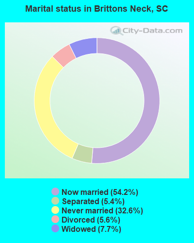
- Never married: 32.6%
- Now married: 54.2%
- Separated: 5.4%
- Widowed: 7.7%
- Divorced: 5.6%
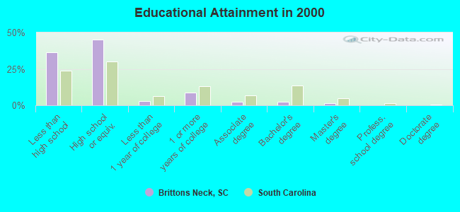
For population 25 years and over in Brittons Neck:
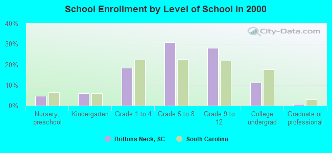
- High school or higher: 63.4%
- Bachelor's degree or higher: 3.8%
- Graduate or professional degree: 1.6%
- Unemployed: 8.8%
- Mean travel time to work (commute): 38.9 minutes
| Here: | 14.7 |
| South Carolina average: | 13.2 |
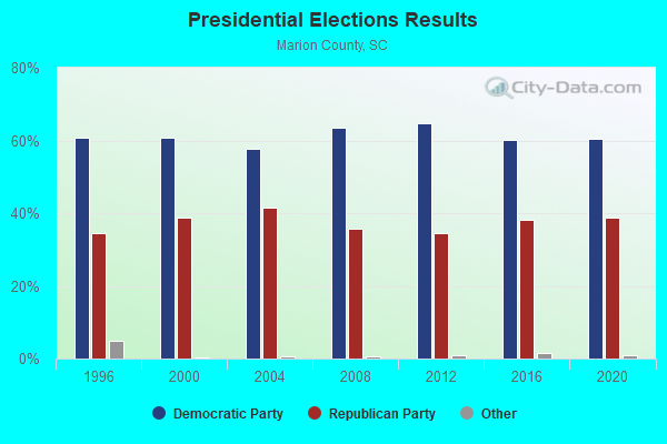
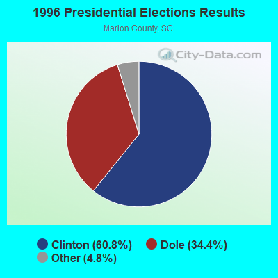
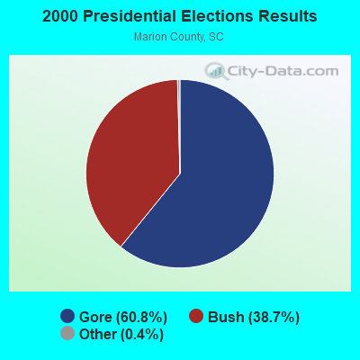
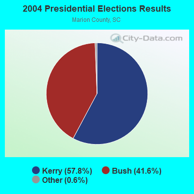
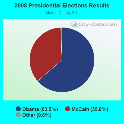
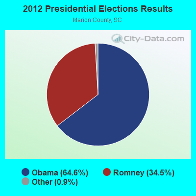
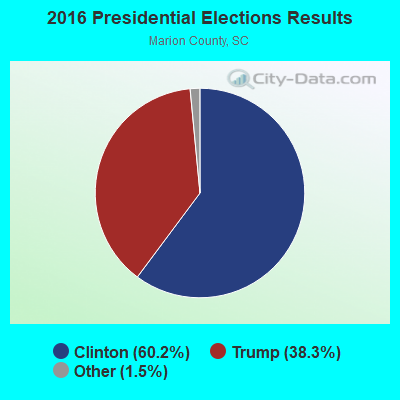
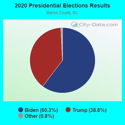
Graphs represent county-level data. Detailed 2008 Election Results
Religion statistics for Brittons Neck, SC (based on Marion County data)
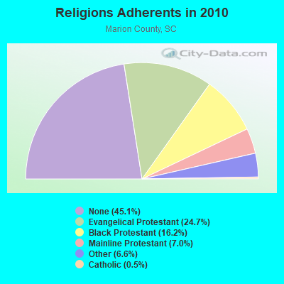
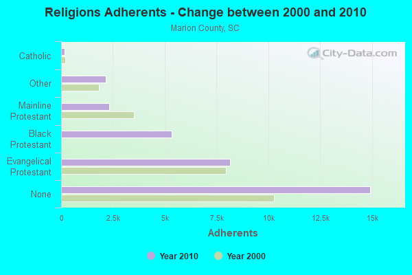
| Religion | Adherents | Congregations |
|---|---|---|
| Evangelical Protestant | 8,160 | 38 |
| Black Protestant | 5,344 | 23 |
| Mainline Protestant | 2,325 | 16 |
| Other | 2,166 | 2 |
| Catholic | 150 | 1 |
| None | 14,917 | - |
Food Environment Statistics:
| Marion County: | 3.25 / 10,000 pop. |
| South Carolina: | 1.99 / 10,000 pop. |
| Marion County: | 1.18 / 10,000 pop. |
| State: | 0.85 / 10,000 pop. |
| Here: | 7.38 / 10,000 pop. |
| South Carolina: | 5.38 / 10,000 pop. |
| This county: | 5.02 / 10,000 pop. |
| South Carolina: | 7.75 / 10,000 pop. |
| Here: | 14.1% |
| State: | 10.6% |
| This county: | 35.2% |
| South Carolina: | 29.4% |
| Marion County: | 15.3% |
| State: | 13.4% |
Businesses in Brittons Neck, SC
- Subway: 1
Strongest AM radio stations in Brittons Neck:
- WPJS (1330 AM; 5 kW; CONWAY, SC; Owner: WPJS BROADCASTING, INC.)
- WQJM (1450 AM; 10 kW; MYRTLE BEACH, SC; Owner: NM LICENSING, LLC)
- WJMX (970 AM; 10 kW; FLORENCE, SC; Owner: QANTUM OF FLORENCE LICENSE COMPANY, LLC)
- WHYM (1260 AM; 5 kW; LAKE CITY, SC; Owner: GHB OF LAKE CITY, INC.)
- WCEO (840 AM; daytime; 50 kW; COLUMBIA, SC; Owner: EASTERN BROADCASTING GROUP, INC.)
- WJAY (1280 AM; 4 kW; MULLINS, SC; Owner: THE GREATER HWY CHURCH OF CHRIST)
- WMIR (1200 AM; 6 kW; ATLANTIC BEACH, SC; Owner: ATLANTIC BEACH RADIO, INC.)
- WBAJ (890 AM; daytime; 50 kW; BLYTHEWOOD, SC; Owner: FAMILY FIRST)
- WDKD (1310 AM; 5 kW; KINGSTREE, SC; Owner: MILLER COMMUNICATIONS, INC.)
- WPTF (680 AM; 50 kW; RALEIGH, NC; Owner: FIRST STATE COMMUNICATIONS)
- WTAB (1370 AM; 5 kW; TABOR CITY, NC; Owner: WTAB, INC)
- WIQB (1050 AM; 25 kW; CONWAY, SC; Owner: CUMULUS LICENSING CORP.)
- WBT (1110 AM; 50 kW; CHARLOTTE, NC; Owner: JEFFERSON-PILOT COMMUNICATNS CO. OF NORTH CAROLINA)
Strongest FM radio stations in Brittons Neck:
- WPDT (105.1 FM; JOHNSONVILLE, SC; Owner: GLORY COMMUNICATIONS, INC.)
- WHMC-FM (90.1 FM; CONWAY, SC; Owner: SOUTH CAROLINA EDUCATIONAL TV COMMISSION)
- WLGI (90.9 FM; HEMINGWAY, SC; Owner: LOUIS G. GREGORY BAHA'I INSTITUTE)
- WEGX (92.9 FM; DILLON, SC; Owner: QANTUM OF FLORENCE LICENSE COMPANY, LLC)
- WYAV (104.1 FM; MYRTLE BEACH, SC; Owner: NM LICENSING, LLC)
- WMYB (92.1 FM; MYRTLE BEACH, SC; Owner: NM LICENSING, LLC)
- WCSQ (92.5 FM; MONCKS CORNER, SC; Owner: APEX BROADCASTING, INC.)
- WGTR (107.9 FM; BUCKSPORT, SC; Owner: QANTUM OF MYRTLE BEACH LICENSE COMPANY, LLC)
- WYEZ (94.5 FM; MURRELLS INLET, SC; Owner: FIDELITY BROADCASTING CORPORATION)
- WWXM (97.7 FM; GARDEN CITY, SC; Owner: QANTUM OF MYRTLE BEACH LICENSE COMPANY, LLC)
- WKZQ-FM (101.7 FM; MYRTLE BEACH, SC; Owner: NM LICENSING, LLC)
- WJXY-FM (93.9 FM; CONWAY, SC; Owner: CUMULUS LICENSING CORP.)
- WQSD (107.1 FM; BRIARCLIFF ACRES, SC; Owner: QANTUM OF MYRTLE BEACH LICENSE COMPANY, LLC)
- WRNN (99.5 FM; SOCASTEE, SC; Owner: NM LICENSING, LLC)
- WDAI (98.5 FM; PAWLEYS ISLAND, SC; Owner: CUMULUS LICENSING CORP.)
- WYAK-FM (103.1 FM; SURFSIDE BEACH, SC; Owner: CUMULUS LICENSING CORP.)
- WURV (102.9 FM; SCRANTON, SC; Owner: QANTUM OF FLORENCE LICENSE COMPANY, LLC)
- WMXT (102.1 FM; PAMPLICO, SC; Owner: CUMULUS LICENSING CORP.)
- WWFN (100.1 FM; LAKE CITY, SC; Owner: CUMULUS LICENSING CORP.)
TV broadcast stations around Brittons Neck:
- WHMC (Channel 23; CONWAY, SC; Owner: SOUTH CAROLINA EDUCATIONAL TV COMMISSION)
- WPDE-TV (Channel 15; FLORENCE, SC; Owner: GRAND STRAND COMMUNICATIONS)
- WWMB (Channel 21; FLORENCE, SC; Owner: ATLANTIC MEDIA GROUP, INC.)
- WFXB (Channel 43; MYRTLE BEACH, SC; Owner: GE MEDIA, INC.)
- WBTW (Channel 13; FLORENCE, SC; Owner: MEDIA GENERAL BROADCASTING OF SO. CAROLINA HOLDINGS, INC.)
- WSFX-TV (Channel 26; WILMINGTON, NC; Owner: SOUTHEASTERN MEDIA HOLDINGS, INC.)
- W66DE (Channel 50; FLORENCE, SC; Owner: CAROLINA CHRISTIAN BROADCASTING, INC.)
- W49AN (Channel 49; MYRTLE BEACH, SC; Owner: DOVE BROADCASTING, INC.)
- WJPM-TV (Channel 33; FLORENCE, SC; Owner: SOUTH CAROLINA EDUCATIONAL TV COMMISSION)
- W51AT (Channel 51; GEORGETOWN, SC; Owner: DOVE BROADCASTING, INC.)
- WPDF-LP (Channel 56; FLORENCE, SC; Owner: GE MEDIA, INC.)
- WWSC-LP (Channel 28; MYRTLE BEACH, SC; Owner: WWSC TELEVISION, INC.)
- W34CQ (Channel 34; MYRTLE BEACH, SC; Owner: TRINITY BROADCASTING NETWORK)
FCC Registered Antenna Towers:
21 (See the full list of FCC Registered Antenna Towers in Brittons Neck)FCC Registered Broadcast Land Mobile Towers:
1- Brttton Neck Fire Tower In Us Hwy 378 & Sc Hwy 908 (Lat: 33.858500 Lon: -79.322000), Call Sign: KII637,
Assigned Frequencies: 159.270 MHz, 159.450 MHz, Grant Date: 01/06/2012, Expiration Date: 01/10/2022, Cancellation Date: 12/31/2012, Registrant: South Carolina Forestry Commission, Columbia, SC 29221, Phone: (803) 896-8800, Fax: (803) 798-8097, Email:
FCC Registered Microwave Towers:
2- STATION, 3.5 Mi Se On Us Hwy 378 (Lat: 33.863194 Lon: -79.329750), Overall height: 91.4 m, Call Sign: WNEG644,
Assigned Frequencies: 6765.00 MHz, Grant Date: 02/03/2021, Expiration Date: 03/26/2031, Certifier: Clifford B Jordan Jr., Registrant: Gray Miller Persh LLP, 2233 Wisconsin Ave., Nw, Ste. 226, Washington, DC 20007, Phone: (202) 776-2458, Email:
- BRITTONSNECK, 8329 Highway 908 (Lat: 33.865389 Lon: -79.330278), Type: Ltower, Structure height: 91.7 m, Overall height: 92.9 m, Call Sign: WRDQ287,
Assigned Frequencies: 11365.0 MHz, 11365.0 MHz, 11365.0 MHz, 11365.0 MHz, 11365.0 MHz, 11365.0 MHz, 11365.0 MHz, 11365.0 MHz, 11365.0 MHz, 11365.0 MHz, 11365.0 MHz, Grant Date: 06/25/2019, Expiration Date: 06/25/2029, Cancellation Date: 09/04/2020, Certifier: Tom Smith, Registrant: Motorola Solutions Inc., 1455 Pennsylvania Ave., #900, Washington, DC 20004, Phone: (847) 877-7179, Email:
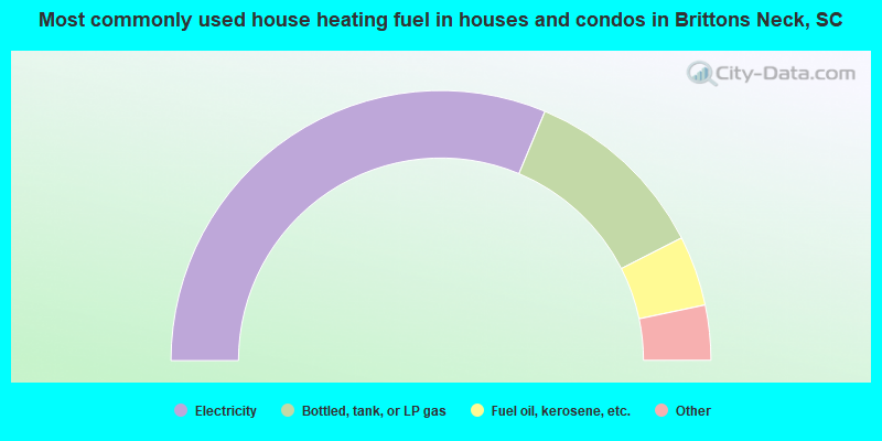
- 62.6%Electricity
- 22.4%Bottled, tank, or LP gas
- 8.4%Fuel oil, kerosene, etc.
- 3.9%Wood
- 2.7%Utility gas
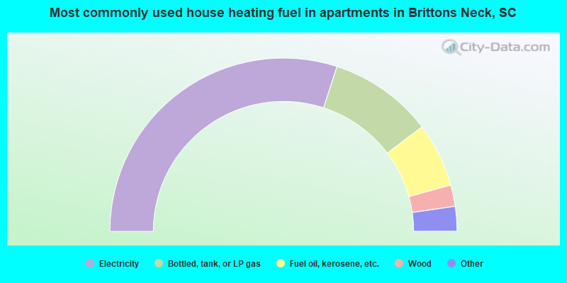
- 60.0%Electricity
- 19.4%Bottled, tank, or LP gas
- 12.0%Fuel oil, kerosene, etc.
- 4.0%Wood
- 3.4%Utility gas
- 1.1%No fuel used
Brittons Neck compared to South Carolina state average:
- Median household income below state average.
- Median house value significantly below state average.
- Unemployed percentage below state average.
- Black race population percentage above state average.
- Foreign-born population percentage significantly below state average.
- Length of stay since moving in significantly above state average.
- Number of rooms per house significantly below state average.
- House age significantly below state average.
- Number of college students below state average.
- Percentage of population with a bachelor's degree or higher significantly below state average.