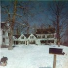
Danville, New Hampshire
Submit your own pictures of this town and show them to the world
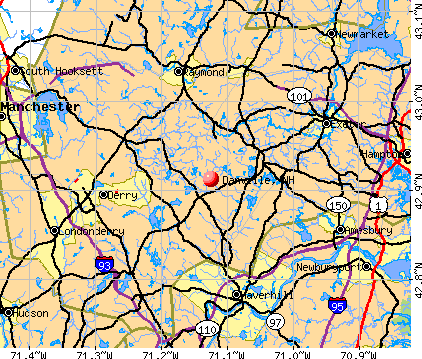
- OSM Map
- General Map
- Google Map
- MSN Map
Population change since 2000: +9.0%
 |
| Males: 2,224 | |
| Females: 2,163 |
| Median resident age: | 41.5 years |
| New Hampshire median age: | 43.9 years |
Zip codes: 03819.
| Danville: | $105,847 |
| NH: | $89,992 |
Estimated per capita income in 2022: $48,626 (it was $22,152 in 2000)
Danville town income, earnings, and wages data
Estimated median house or condo value in 2022: $447,338 (it was $146,400 in 2000)
| Danville: | $447,338 |
| NH: | $384,700 |
Mean prices in 2022: all housing units: $614,227; detached houses: $665,470; townhouses or other attached units: $408,866; in 2-unit structures: $730,084; in 3-to-4-unit structures: over $1,000,000; in 5-or-more-unit structures: $329,099; mobile homes: $126,160
Detailed information about poverty and poor residents in Danville, NH
Compare current foreclosures near Danville, NH:
| Photo | Address | Area | Beds / Baths | Price | Details |
|---|---|---|---|---|---|

|
#1
Brentwood Rd
Exeter, NH 03833
|
2,756 sq. feet
|
2 baths 3 beds |
$419,900
|
show details |

|
#2
Cedar St # A
Haverhill, MA 01830
|
1,134 sq. feet
|
2 baths 2 beds |
$209,300
|
show details |

|
#3
Cortland Cir
Danville, NH 03819
|
- sq. feet
|
- baths - beds |
show details | |

|
#4
Fawn Ln
Danville, NH 03819
|
- sq. feet
|
- baths - beds |
show details | |

|
#5
Redfield Cir
Derry, NH 03038
|
2,124 sq. feet
|
3 baths 4 beds |
show details | |

|
#6
High St
Derry, NH 03038
|
2,149 sq. feet
|
3 baths 4 beds |
show details | |

|
#7
Michael Ave
Derry, NH 03038
|
1,536 sq. feet
|
1 baths 4 beds |
show details | |

|
#8
Pine Ridge Rd
Windham, NH 03087
|
1,746 sq. feet
|
2 baths 4 beds |
show details | |

|
#9
Lawrence Rd
Salem, NH 03079
|
1,305 sq. feet
|
1 baths 1 beds |
show details | |

|
#10
Maclarnon Rd
Salem, NH 03079
|
1,578 sq. feet
|
2 baths 3 beds |
show details |
| Photo | Address | Area | Beds / Baths | Price | Details |
|---|---|---|---|---|---|

|
#11
Smoke St
Nottingham, NH 03290
|
2,396 sq. feet
|
3 baths 3 beds |
show details | |

|
#12
Brook St
Derry, NH 03038
|
1,476 sq. feet
|
2 baths 4 beds |
show details | |

|
#13
Cedar St
Manchester, NH 03103
|
2,614 sq. feet
|
2 baths 6 beds |
show details | |

|
#14
Del Logan Dr
Salisbury, MA 01952
|
1,986 sq. feet
|
1 baths 3 beds |
show details | |

|
#15
Marshall St
Methuen, MA 01844
|
840 sq. feet
|
1 baths 2 beds |
show details | |

|
#16
Anderson Dr
Methuen, MA 01844
|
2,592 sq. feet
|
2 baths 4 beds |
show details | |

|
#17
Farnham Rd
Rowley, MA 01969
|
1,106 sq. feet
|
2 baths 3 beds |
show details | |

|
#18
Weymouth Ave
Methuen, MA 01844
|
1,666 sq. feet
|
1 baths 3 beds |
show details | |

|
#19
Comet Rd
Methuen, MA 01844
|
1,640 sq. feet
|
1 baths 3 beds |
show details | |

|
#20
Clay St # 2
Manchester, NH 03103
|
2,240 sq. feet
|
2 baths 4 beds |
show details |
| Photo | Address | Area | Beds / Baths | Price | Details |
|---|---|---|---|---|---|

|
#21
Gove Dr
Newburyport, MA 01950
|
3,044 sq. feet
|
3 baths 3 beds |
show details | |

|
#22
Storey Ave Apt 2
Newburyport, MA 01950
|
708 sq. feet
|
1 baths 2 beds |
show details | |

|
#23
Rivers Edge Pl
Methuen, MA 01844
|
1,428 sq. feet
|
2 baths 3 beds |
show details | |

|
#24
Megan Dr
Manchester, NH 03109
|
2,244 sq. feet
|
1 baths 3 beds |
show details | |

|
#25
Golf Ave
Methuen, MA 01844
|
2,208 sq. feet
|
1 baths 3 beds |
show details | |

|
#26
Merrimack St # 2
Manchester, NH 03103
|
2,436 sq. feet
|
2 baths 6 beds |
show details | |

|
#27
Center St
Groveland, MA 01834
|
1,923 sq. feet
|
2 baths 2 beds |
show details | |

|
#28
Elm St
Salisbury, MA 01952
|
1,800 sq. feet
|
2 baths 4 beds |
show details | |

|
#29
Greendale St
Methuen, MA 01844
|
1,777 sq. feet
|
1 baths 3 beds |
show details | |

|
#30
Florence Rd
Methuen, MA 01844
|
1,580 sq. feet
|
2 baths 3 beds |
show details |
| Photo | Address | Area | Beds / Baths | Price | Details |
|---|---|---|---|---|---|

|
#31
Byfield Rd
Groveland, MA 01834
|
1,488 sq. feet
|
2 baths 3 beds |
show details | |

|
#32
King St
Groveland, MA 01834
|
2,713 sq. feet
|
3 baths 4 beds |
show details | |

|
#33
Salem St
Methuen, MA 01844
|
1,736 sq. feet
|
2 baths 3 beds |
show details | |

|
#34
Riverview Blvd Apt 8-108
Methuen, MA 01844
|
1,303 sq. feet
|
2 baths 2 beds |
show details | |

|
#35
Beedle Ter
Methuen, MA 01844
|
1,507 sq. feet
|
2 baths 4 beds |
show details | |

|
#36
King St
Methuen, MA 01844
|
1,451 sq. feet
|
1 baths 3 beds |
show details | |

|
#37
William St
Lawrence, MA 01841
|
1,500 sq. feet
|
2 baths 3 beds |
show details | |

|
#38
Christopher Dr Apt 114
Methuen, MA 01844
|
1,040 sq. feet
|
2 baths 2 beds |
show details | |

|
#39
Cluff Crossing Rd
Salem, NH 03079
|
1,120 sq. feet
|
2 baths 2 beds |
show details | |

|
#40
Oakwood Ave
Lawrence, MA 01841
|
2,752 sq. feet
|
2 baths 6 beds |
show details |
| Photo | Address | Area | Beds / Baths | Price | Details |
|---|---|---|---|---|---|

|
#41
Main St
West Newbury, MA 01985
|
2,934 sq. feet
|
2 baths 5 beds |
show details | |

|
#42
Brook St
Derry, NH 03038
|
1,476 sq. feet
|
1 baths 4 beds |
show details | |

|
#43
Brook St
Derry, NH 03038
|
1,666 sq. feet
|
1 baths 4 beds |
show details | |

|
#44
Hazen Ave
Haverhill, MA 01830
|
2,594 sq. feet
|
2 baths 7 beds |
show details | |

|
#45
Webster St
Salem, NH 03079
|
1,912 sq. feet
|
2 baths 3 beds |
show details | |

|
#46
Gauthier Way
Pelham, NH 03076
|
2,752 sq. feet
|
2 baths 3 beds |
show details | |

|
#47
Everett St
Derry, NH 03038
|
1,596 sq. feet
|
1 baths 3 beds |
show details | |

|
#48
S Webster St
Haverhill, MA 01835
|
978 sq. feet
|
1 baths 2 beds |
show details | |

|
#49
Parkview Ave
Salem, NH 03079
|
1,812 sq. feet
|
1 baths 3 beds |
show details | |

|
Check over 1 million property listings on Foreclosure.com!
|
browse all offers | |||

- 4,19495.6%White alone
- 701.6%Two or more races
- 681.6%Hispanic
- 280.6%Black alone
- 130.3%Asian alone
- 70.2%American Indian alone
- 50.1%Other race alone
- 20.05%Native Hawaiian and Other
Pacific Islander alone

Races in Danville detailed stats: ancestries, foreign born residents, place of birth
According to our research of New Hampshire and other state lists, there were 5 registered sex offenders living in Danville, New Hampshire as of May 21, 2024.
The ratio of all residents to sex offenders in Danville is 877 to 1.
The ratio of registered sex offenders to all residents in this city is lower than the state average.
Type |
2009 |
2010 |
2011 |
2012 |
2013 |
2014 |
2015 |
2016 |
2017 |
2018 |
2019 |
2020 |
2021 |
2022 |
|---|---|---|---|---|---|---|---|---|---|---|---|---|---|---|
| Murders (per 100,000) | 0 (0.0) | 1 (22.8) | 0 (0.0) | 0 (0.0) | 0 (0.0) | 0 (0.0) | 0 (0.0) | 1 (22.4) | 0 (0.0) | 0 (0.0) | 0 (0.0) | 0 (0.0) | 0 (0.0) | 0 (0.0) |
| Rapes (per 100,000) | 1 (22.9) | 1 (22.8) | 0 (0.0) | 0 (0.0) | 0 (0.0) | 0 (0.0) | 1 (22.3) | 0 (0.0) | 1 (22.4) | 0 (0.0) | 0 (0.0) | 1 (21.8) | 0 (0.0) | 0 (0.0) |
| Robberies (per 100,000) | 0 (0.0) | 0 (0.0) | 0 (0.0) | 0 (0.0) | 0 (0.0) | 1 (22.4) | 0 (0.0) | 0 (0.0) | 0 (0.0) | 0 (0.0) | 0 (0.0) | 0 (0.0) | 0 (0.0) | 0 (0.0) |
| Assaults (per 100,000) | 1 (22.9) | 2 (45.6) | 1 (22.8) | 2 (45.4) | 0 (0.0) | 1 (22.4) | 2 (44.6) | 2 (44.8) | 3 (67.1) | 0 (0.0) | 0 (0.0) | 2 (43.7) | 2 (42.8) | 0 (0.0) |
| Burglaries (per 100,000) | 18 (411.4) | 9 (205.2) | 10 (227.6) | 14 (317.5) | 9 (200.4) | 5 (112.2) | 3 (66.9) | 1 (22.4) | 3 (67.1) | 0 (0.0) | 3 (65.4) | 1 (21.8) | 0 (0.0) | 0 (0.0) |
| Thefts (per 100,000) | 36 (822.9) | 35 (797.8) | 36 (819.5) | 53 (1,202) | 26 (579.1) | 16 (359.0) | 26 (579.6) | 20 (447.8) | 24 (536.8) | 10 (217.6) | 5 (109.1) | 2 (43.7) | 8 (171.0) | 3 (65.3) |
| Auto thefts (per 100,000) | 3 (68.6) | 4 (91.2) | 1 (22.8) | 5 (113.4) | 0 (0.0) | 0 (0.0) | 1 (22.3) | 1 (22.4) | 1 (22.4) | 1 (21.8) | 3 (65.4) | 1 (21.8) | 1 (21.4) | 1 (21.8) |
| Arson (per 100,000) | 0 (0.0) | 1 (22.8) | 1 (22.8) | 0 (0.0) | 0 (0.0) | 0 (0.0) | 0 (0.0) | 0 (0.0) | 0 (0.0) | 0 (0.0) | 0 (0.0) | 0 (0.0) | 0 (0.0) | 0 (0.0) |
| City-Data.com crime index | 90.1 | 126.5 | 55.1 | 88.5 | 37.2 | 33.4 | 56.4 | 75.0 | 59.3 | 10.4 | 14.2 | 31.2 | 17.1 | 4.4 |
The City-Data.com crime index weighs serious crimes and violent crimes more heavily. Higher means more crime, U.S. average is 246.1. It adjusts for the number of visitors and daily workers commuting into cities.

Crime rate in Danville detailed stats: murders, rapes, robberies, assaults, burglaries, thefts, arson
Full-time law enforcement employees in 2021, including police officers: 5 (5 officers - 4 male; 1 female).
| Officers per 1,000 residents here: | 1.07 |
| New Hampshire average: | 2.14 |
 Recent articles from our blog. Our writers, many of them Ph.D. graduates or candidates, create easy-to-read articles on a wide variety of topics.


 | Thoughts on the Free State Project (82 replies) |
| Pros/Cons of living in a house on a dirt road (66 replies) |
| Family with 2 children considering a move to Danville NH. (1 reply) |
| Internet Service Fears (14 replies) |
| Relocation to new hampshire (28 replies) |
| Looking to relocate to Nashua NH area (12 replies) |
Latest news from Danville, NH collected exclusively by city-data.com from local newspapers, TV, and radio stations
Ancestries: Irish (25.4%), English (19.1%), French (15.9%), Italian (12.7%), French Canadian (10.8%), United States (8.0%).
Current Local Time: EST time zone
Incorporated in 1760
Elevation: 200 feet
Land area: 11.7 square miles.
Population density: 375 people per square mile (very low).

92 residents are foreign born (1.5% Europe, 0.5% North America).
| This town: | 2.3% |
| New Hampshire: | 4.4% |
| Danville town: | 2.2% ($3,149) |
| New Hampshire: | 2.3% ($2,946) |
Nearest city with pop. 50,000+: Haverhill, MA  (10.3 miles , pop. 58,969).
Nearest city with pop. 200,000+: Boston, MA (41.7 miles , pop. 589,141).
Nearest city with pop. 1,000,000+: Bronx, NY (201.7 miles , pop. 1,332,650).
Nearest cities:
), ), ), ), Latitude: 42.92 N, Longitude: 71.12 W
Area code commonly used in this area: 603


Single-family new house construction building permits:
- 2022: 17 buildings, average cost: $298,700
- 2021: 8 buildings, average cost: $262,500
- 2020: 40 buildings, average cost: $265,300
- 2019: 24 buildings, average cost: $263,800
- 2018: 14 buildings, average cost: $240,300
- 2017: 8 buildings, average cost: $245,400
- 2016: 12 buildings, average cost: $143,200
- 2015: 5 buildings, average cost: $144,300
- 2014: 6 buildings, average cost: $147,100
- 2013: 2 buildings, average cost: $233,000
- 2012: 1 building, cost: $130,000
- 2011: 7 buildings, average cost: $155,900
- 2010: 12 buildings, average cost: $154,500
- 2009: 3 buildings, average cost: $165,300
- 2007: 12 buildings, average cost: $165,300
- 2006: 4 buildings, average cost: $104,300
- 2005: 4 buildings, average cost: $156,300
- 2004: 19 buildings, average cost: $141,800
- 2003: 23 buildings, average cost: $182,000
- 2002: 50 buildings, average cost: $144,500
- 2001: 19 buildings, average cost: $103,100
- 2000: 23 buildings, average cost: $96,200
- 1999: 18 buildings, average cost: $82,900
- 1998: 65 buildings, average cost: $66,100
- 1997: 83 buildings, average cost: $80,700


| Here: | 3.0% |
| New Hampshire: | 2.5% |


- Construction (10.7%)
- Health care (7.7%)
- Computer & electronic products (6.3%)
- Professional, scientific, technical services (5.8%)
- Administrative & support & waste management services (5.2%)
- Educational services (5.2%)
- Food & beverage stores (3.9%)

- Construction (15.5%)
- Administrative & support & waste management services (8.2%)
- Computer & electronic products (6.7%)
- Professional, scientific, technical services (5.6%)
- Educational services (4.0%)
- Metal & metal products (3.9%)
- Food & beverage stores (3.8%)

- Health care (15.0%)
- Educational services (6.5%)
- Professional, scientific, technical services (6.0%)
- Computer & electronic products (5.9%)
- Construction (5.1%)
- Finance & insurance (4.4%)
- Accommodation & food services (4.0%)

- Other sales and related occupations, including supervisors (5.6%)
- Other management occupations, except farmers and farm managers (5.3%)
- Other office and administrative support workers, including supervisors (5.0%)
- Retail sales workers, except cashiers (4.7%)
- Other production occupations, including supervisors (4.5%)
- Secretaries and administrative assistants (4.3%)
- Computer specialists (4.0%)

- Other sales and related occupations, including supervisors (7.2%)
- Other management occupations, except farmers and farm managers (6.8%)
- Electrical equipment mechanics and other installation, maintenance, and repair workers, including supervisors (5.3%)
- Computer specialists (5.3%)
- Vehicle and mobile equipment mechanics, installers, and repairers (5.3%)
- Building and grounds cleaning and maintenance occupations (5.1%)
- Driver/sales workers and truck drivers (4.9%)

- Other office and administrative support workers, including supervisors (10.8%)
- Secretaries and administrative assistants (9.2%)
- Retail sales workers, except cashiers (5.7%)
- Other production occupations, including supervisors (4.5%)
- Preschool, kindergarten, elementary, and middle school teachers (4.2%)
- Registered nurses (4.2%)
- Customer service representatives (3.8%)
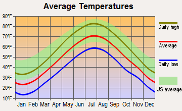
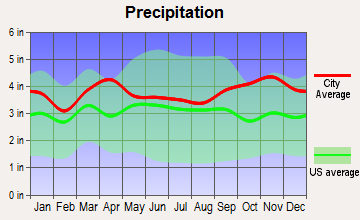
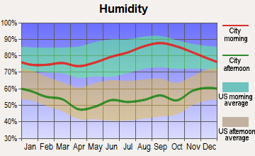
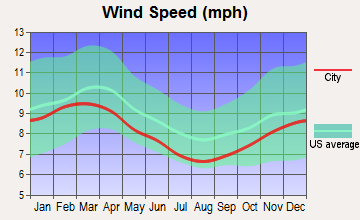
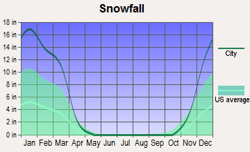
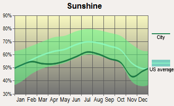
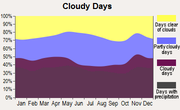
Average climate in Danville, New Hampshire
Based on data reported by over 4,000 weather stations
(lower is better)

Air Quality Index (AQI) level in 2022 was 66.4. This is about average.
| City: | 66.4 |
| U.S.: | 72.6 |

Carbon Monoxide (CO) [ppm] level in 2022 was 0.157. This is significantly better than average. Closest monitor was 13.7 miles away from the city center.
| City: | 0.157 |
| U.S.: | 0.251 |

Nitrogen Dioxide (NO2) [ppb] level in 2022 was 5.50. This is about average. Closest monitor was 6.5 miles away from the city center.
| City: | 5.50 |
| U.S.: | 5.11 |

Sulfur Dioxide (SO2) [ppb] level in 2022 was 0.679. This is significantly better than average. Closest monitor was 10.3 miles away from the city center.
| City: | 0.679 |
| U.S.: | 1.515 |

Ozone [ppb] level in 2022 was 28.7. This is about average. Closest monitor was 10.7 miles away from the city center.
| City: | 28.7 |
| U.S.: | 33.3 |

Particulate Matter (PM10) [µg/m3] level in 2022 was 11.7. This is significantly better than average. Closest monitor was 13.7 miles away from the city center.
| City: | 11.7 |
| U.S.: | 19.2 |

Particulate Matter (PM2.5) [µg/m3] level in 2022 was 6.42. This is better than average. Closest monitor was 10.7 miles away from the city center.
| City: | 6.42 |
| U.S.: | 8.11 |
Tornado activity:
Danville-area historical tornado activity is slightly above New Hampshire state average. It is 44% smaller than the overall U.S. average.
On 6/9/1953, a category F3 (max. wind speeds 158-206 mph) tornado 8.3 miles away from the Danville town center injured 5 people and caused between $5000 and $50,000 in damages.
On 9/29/1974, a category F3 tornado 21.4 miles away from the town center injured one person and caused between $50,000 and $500,000 in damages.
Earthquake activity:
Danville-area historical earthquake activity is significantly above New Hampshire state average. It is 72% smaller than the overall U.S. average.On 4/20/2002 at 10:50:47, a magnitude 5.3 (5.3 ML, Depth: 3.0 mi, Class: Moderate, Intensity: VI - VII) earthquake occurred 169.2 miles away from Danville center
On 1/19/1982 at 00:14:42, a magnitude 4.7 (4.5 MB, 4.7 MD, 4.5 LG, Class: Light, Intensity: IV - V) earthquake occurred 46.5 miles away from Danville center
On 10/7/1983 at 10:18:46, a magnitude 5.3 (5.1 MB, 5.3 LG, 5.1 ML) earthquake occurred 176.6 miles away from Danville center
On 10/16/2012 at 23:12:25, a magnitude 4.7 (4.7 ML, Depth: 10.0 mi) earthquake occurred 52.2 miles away from the city center
On 4/20/2002 at 10:50:47, a magnitude 5.2 (5.2 MB, 4.2 MS, 5.2 MW, 5.0 MW) earthquake occurred 168.9 miles away from Danville center
On 8/22/1992 at 12:20:32, a magnitude 4.8 (4.8 MB, 3.8 MS, 4.7 LG, Depth: 6.2 mi) earthquake occurred 267.4 miles away from the city center
Magnitude types: regional Lg-wave magnitude (LG), body-wave magnitude (MB), duration magnitude (MD), local magnitude (ML), surface-wave magnitude (MS), moment magnitude (MW)
Natural disasters:
The number of natural disasters in Rockingham County (26) is a lot greater than the US average (15).Major Disasters (Presidential) Declared: 17
Emergencies Declared: 9
Causes of natural disasters: Storms: 12, Floods: 9, Winter Storms: 5, Hurricanes: 4, Snowstorms: 4, Snows: 2, Winds: 2, Blizzard: 1, Snowfall: 1, Tornado: 1 (Note: some incidents may be assigned to more than one category).

Hospitals and medical centers near Danville:
- HAMPSTEAD HOSP (Hospital, about 5 miles away; HAMPSTEAD, NH)
- COLONIAL POPLIN NURSING HOME (Nursing Home, about 5 miles away; FREMONT, NH)
- ROCKINGHAM COUNTY NURSING HOME (Nursing Home, about 8 miles away; BRENTWOOD, NH)
- LENOX NH INC (Nursing Home, about 8 miles away; HAVERHILL, MA)
- RIVERWOODS AT EXETER (Nursing Home, about 8 miles away; EXETER, NH)
- KENOZA HILLCREST NURSING HOME (Nursing Home, about 9 miles away; HAVERHILL, MA)
- KENOZA MANOR CONV HOME (Nursing Home, about 9 miles away; HAVERHILL, MA)
Heliports located in Danville:
Operable nuclear power plant near Danville:
- 14 miles: Seabrook in Seabrook, NH.
Colleges/universities with over 2000 students nearest to Danville:
- Northern Essex Community College (about 10 miles; Haverhill, MA; Full-time enrollment: 4,737)
- University of New Hampshire-Main Campus (about 18 miles; Durham, NH; FT enrollment: 15,243)
- Merrimack College (about 18 miles; North Andover, MA; FT enrollment: 2,734)
- Mount Washington College (about 18 miles; Manchester, NH; FT enrollment: 2,187)
- Southern New Hampshire University (about 19 miles; Manchester, NH; FT enrollment: 16,552)
- Saint Anselm College (about 20 miles; Manchester, NH; FT enrollment: 2,059)
- University of Massachusetts-Lowell (about 22 miles; Lowell, MA; FT enrollment: 12,341)
Public elementary/middle school in Danville:
- DANVILLE ELEMENTARY SCHOOL (Students: 373, Location: 23 SCHOOL ST., Grades: PK-5)
Points of interest:
Notable locations in Danville: Danville Camping Area (A), Colby Memorial Library (B), Danville Fire and Rescue (C). Display/hide their locations on the map
Church in Danville: Ye Olde Meeting House (A). Display/hide its location on the map
Cemeteries: Danville Cemetery (1), Center Cemetery (2), Ye Old Cemetery (3). Display/hide their locations on the map
Lakes and reservoirs: Diamond Pond (A), Long Pond (B), Little Cub Pond (C). Display/hide their locations on the map
Streams, rivers, and creeks: Bartlett Brook (A). Display/hide its location on the map
Drinking water stations with addresses in Danville and their reported violations in the past:
DANVILLE FOUR SEASONS (Population served: 200, Groundwater):Past health violations:Past monitoring violations:
- MCL, Average - Between JAN-2014 and MAR-2014, Contaminant: Combined Radium (-226 and -228). Follow-up actions: St Public Notif requested (APR-24-2014), St Violation/Reminder Notice (APR-24-2014), St Formal NOV issued (MAY-19-2014), St Public Notif received (MAY-22-2014)
- MCL, Average - Between OCT-2013 and DEC-2013, Contaminant: Combined Radium (-226 and -228). Follow-up actions: St Public Notif requested (JAN-21-2014), St Violation/Reminder Notice (JAN-21-2014), St Public Notif received (FEB-05-2014), St Formal NOV issued (MAY-19-2014)
- MCL, Monthly (TCR) - In JAN-2012, Contaminant: Coliform. Follow-up actions: St Public Notif requested (FEB-09-2012), St Violation/Reminder Notice (FEB-09-2012), St Public Notif received (FEB-21-2012), St Compliance achieved (JUL-18-2012)
- MCL, Average - Between OCT-2007 and DEC-2007, Contaminant: Arsenic. Follow-up actions: St Public Notif requested (JAN-17-2008), St Violation/Reminder Notice (JAN-17-2008), St Formal NOV issued (MAR-07-2008), St Public Notif received (MAR-24-2008), St BCA signed (MAR-31-2008), St Compliance achieved (OCT-13-2008)
- MCL, Average - Between JUL-2007 and SEP-2007, Contaminant: Arsenic. Follow-up actions: St Public Notif requested (OCT-09-2007), St Violation/Reminder Notice (OCT-09-2007), St Public Notif received (NOV-08-2007), St Formal NOV issued (MAR-07-2008), St BCA signed (MAR-31-2008), St Compliance achieved (OCT-13-2008)
- One routine major monitoring violation
- One regular monitoring violation
Drinking water stations with addresses in Danville that have no violations reported:
- IRON WHEEL MHP (Population served: 107, Primary Water Source Type: Groundwater)
| This town: | 2.8 people |
| New Hampshire: | 2.5 people |
| This town: | 76.7% |
| Whole state: | 66.3% |
| This town: | 8.0% |
| Whole state: | 8.3% |
Likely homosexual households (counted as self-reported same-sex unmarried-partner households)
- Lesbian couples: 0.6% of all households
- Gay men: 0.6% of all households
| This town: | 4.0% |
| Whole state: | 6.5% |
| This town: | 1.3% |
| Whole state: | 2.8% |
3 people in religious group quarters in 2000
For population 15 years and over in Danville:

- Never married: 18.5%
- Now married: 66.3%
- Separated: 1.4%
- Widowed: 2.7%
- Divorced: 11.1%
For population 25 years and over in Danville:
- High school or higher: 90.9%
- Bachelor's degree or higher: 19.0%
- Graduate or professional degree: 4.9%
- Unemployed: 2.5%
- Mean travel time to work (commute): 36.5 minutes


| Here: | 8.3 |
| New Hampshire average: | 10.9 |


Graphs represent county-level data. Detailed 2008 Election Results
Religion statistics for Danville, NH (based on Rockingham County data)


| Religion | Adherents | Congregations |
|---|---|---|
| Catholic | 84,697 | 24 |
| Mainline Protestant | 19,072 | 78 |
| Evangelical Protestant | 7,456 | 61 |
| Other | 3,490 | 20 |
| Orthodox | 200 | 1 |
| None | 180,308 | - |
Food Environment Statistics:
| This county: | 1.59 / 10,000 pop. |
| New Hampshire: | 2.14 / 10,000 pop. |
| Here: | 0.17 / 10,000 pop. |
| New Hampshire: | 0.15 / 10,000 pop. |
| Here: | 1.86 / 10,000 pop. |
| State: | 1.78 / 10,000 pop. |
| Rockingham County: | 3.31 / 10,000 pop. |
| New Hampshire: | 4.02 / 10,000 pop. |
| Rockingham County: | 9.56 / 10,000 pop. |
| State: | 9.70 / 10,000 pop. |
| This county: | 7.6% |
| New Hampshire: | 7.6% |
| This county: | 23.3% |
| State: | 24.4% |
| This county: | 16.8% |
| New Hampshire: | 15.9% |
7.69% of this county's 2021 resident taxpayers lived in other counties in 2020 ($114,534 average adjusted gross income)
| Here: | 7.69% |
| New Hampshire average: | 7.66% |
0.01% of residents moved from foreign countries ($203 average AGI)
Rockingham County: 0.01% New Hampshire average: 0.01%
Top counties from which taxpayers relocated into this county between 2020 and 2021:
| from Essex County, MA | |
| from Hillsborough County, NH | |
| from Middlesex County, MA |
6.82% of this county's 2020 resident taxpayers moved to other counties in 2021 ($88,778 average adjusted gross income)
| Here: | 6.82% |
| New Hampshire average: | 6.80% |
0.01% of residents moved to foreign countries ($126 average AGI)
Rockingham County: 0.01% New Hampshire average: 0.01%
Top counties to which taxpayers relocated from this county between 2020 and 2021:
| to Hillsborough County, NH | |
| to Strafford County, NH | |
| to Essex County, MA |
Businesses in Danville, NH
- MasterBrand Cabinets: 2
Strongest AM radio stations in Danville:
- WDER (1320 AM; 10 kW; DERRY, NH; Owner: BLOUNT COMMUNICATIONS, INC. OF NH)
- WRKO (680 AM; 50 kW; BOSTON, MA; Owner: ENTERCOM BOSTON LICENSE, LLC)
- WGIP (1540 AM; 5 kW; EXETER, NH; Owner: CAPSTAR TX LIMITED PARTNERSHIP)
- WEEI (850 AM; 50 kW; BOSTON, MA; Owner: ENTERCOM BOSTON LICENSE, LLC)
- WCEC (1110 AM; daytime; 5 kW; SALEM, NH; Owner: COSTA-EAGLE RADIO VENTURES LTD PARTNERSHIP)
- WWZN (1510 AM; 50 kW; BOSTON, MA; Owner: ROSE CITY RADIO CORPORATION)
- WBZ (1030 AM; 50 kW; BOSTON, MA; Owner: INFINITY BROADCASTING OPERATIONS, INC.)
- WGIR (610 AM; 5 kW; MANCHESTER, NH; Owner: CAPSTAR TX LIMITED PARTNERSHIP)
- WKOX (1200 AM; 50 kW; FRAMINGHAM, MA; Owner: CAPSTAR TX LIMITED PARTNERSHIP)
- WBIX (1060 AM; 40 kW; NATICK, MA; Owner: LANGER BROADCASTING CORPORATION)
- WCRN (830 AM; 50 kW; WORCESTER, MA; Owner: CARTER BROADCASTING CORPORATION)
- WGIN (930 AM; 10 kW; ROCHESTER, NH; Owner: CAPSTAR TX LIMITED PARTNERSHIP)
- WFEA (1370 AM; 5 kW; MANCHESTER, NH; Owner: SAGA COMMUNICATIONS OF NEW ENGLAND, LLC)
Strongest FM radio stations in Danville:
- WXRV (92.5 FM; HAVERHILL, MA; Owner: BEANPOT BROADCASTING CORP.)
- WNEF (91.7 FM; NEWBURYPORT, MA; Owner: UNIVERSITY OF MASSACHUSETTS)
- WGIR-FM (101.1 FM; MANCHESTER, NH; Owner: CAPSTAR TX LIMITED PARTNERSHIP)
- WQLL (96.5 FM; BEDFORD, NH; Owner: SAGA COMMUNICATIONS OF NEW ENGLAND, LLC)
- WLMW (90.7 FM; MANCHESTER, NH; Owner: KNOWLEDGE FOR LIFE)
- WZID (95.7 FM; MANCHESTER, NH; Owner: SAGA COMMUNICATIONS OF NEW ENGLAND, LLC)
- WSAK (102.1 FM; HAMPTON, NH; Owner: CITADEL BROADCASTING COMPANY)
- WKLB-FM (99.5 FM; LOWELL, MA; Owner: GREATER BOSTON RADIO, INC.)
- W227AM (93.3 FM; ANDOVER, MA; Owner: GREATER BOSTON RADIO, INC.)
- WHOB (106.3 FM; NASHUA, NH; Owner: TELE-MEDIA COMPANY OF NEW HAMPSHIRE, L.L.C.)
- WFEX (92.1 FM; PETERBOROUGH, NH; Owner: FNX BROADCASTING OF NEW HAMPSHIRE LLC)
- WERZ (107.1 FM; EXETER, NH; Owner: CAPSTAR TX LIMITED PARTNERSHIP)
- WSCY (106.9 FM; MOULTONBOROUGH, NH; Owner: NORTHEAST COMMUNICATIONS CORPORATION)
- WXKS-FM (107.9 FM; MEDFORD, MA; Owner: AMFM RADIO LICENSES, L.L.C.)
- WHEB (100.3 FM; PORTSMOUTH, NH; Owner: CAPSTAR TX LIMITED PARTNERSHIP)
- WMJX (106.7 FM; BOSTON, MA; Owner: GREATER BOSTON RADIO, INC.)
- WOKQ (97.5 FM; DOVER, NH; Owner: CITADEL BROADCASTING COMPANY)
- WBMX (98.5 FM; BOSTON, MA; Owner: INFINITY RADIO OPERATIONS INC.)
- WJMN (94.5 FM; BOSTON, MA; Owner: AMFM RADIO LICENSES, L.L.C.)
- WCRB (102.5 FM; WALTHAM, MA; Owner: CHARLES RIVER BROADCASTING WCRB LICE)
TV broadcast stations around Danville:
- WFXZ-CA (Channel 24; BOSTON, MA; Owner: BOSTON BROADCASTING CORP.)
- WHDN-LP (Channel 26; BOSTON, MA; Owner: GUENTER MARKSTEINER)
- WMEA-TV (Channel 26; BIDDEFORD, ME; Owner: MAINE PUBLIC BROADCASTING CORP.)
- WENH-TV (Channel 11; DURHAM, NH; Owner: UNIVERSITY OF NEW HAMPSHIRE)
- WCVB-TV (Channel 5; BOSTON, MA; Owner: WCVB HEARST-ARGYLE TV, INC.)
- WGBH-TV (Channel 2; BOSTON, MA; Owner: WGBH EDUCATIONAL FOUNDATION)
- WNDS (Channel 50; DERRY, NH; Owner: CTV OF DERRY, INC)
- WHDH-TV (Channel 7; BOSTON, MA; Owner: WHDH-TV)
- WMFP (Channel 62; LAWRENCE, MA; Owner: WSAH LICENSE, INC.)
- WBZ-TV (Channel 4; BOSTON, MA; Owner: VIACOM INC.)
- WGBX-TV (Channel 44; BOSTON, MA; Owner: WGBH EDUCATIONAL FOUNDATION)
- WSBK-TV (Channel 38; BOSTON, MA; Owner: VIACOM INC.)
- WUTF (Channel 66; MARLBOROUGH, MA; Owner: TELEFUTURA BOSTON LLC)
- WLVI-TV (Channel 56; CAMBRIDGE, MA; Owner: WLVI, INC.)
- WFXT (Channel 25; BOSTON, MA; Owner: FOX TELEVISION STATIONS INC.)
- WBPX (Channel 68; BOSTON, MA; Owner: PAXSON BOSTON-68 LICENSE, INC.)
- WUNI (Channel 27; WORCESTER, MA; Owner: ENTRAVISION HOLDINGS, LLC)
- WTMU-LP (Channel 32; BOSTON, MA; Owner: ZGS BOSTON, INC.)
- WCEA-LP (Channel 58; BOSTON, MA; Owner: CHANNEL 19 TV CORPORATION)
- WPXG (Channel 21; CONCORD, NH; Owner: PAXSON BOSTON-68 LICENSE, INC.)

Danville fatal accident list:
Aug 8, 1996 02:58 PM, Route 111, Vehicles: 2, Persons: 3, Fatalities: 2
- National Bridge Inventory (NBI) Statistics
- 1Number of bridges
- 3ft / 0.7mTotal length
- $3,142,000Total costs
- 168Total average daily traffic
- 6Total average daily truck traffic
- 248Total future (year 2042) average daily traffic
FCC Registered Broadcast Land Mobile Towers:
2- Highway Garage, 67 Hersey Road (Lat: 42.929583 Lon: -71.127611), Type: Bant, Structure height: 9.7 m, Overall height: 14.3 m, Call Sign: WZU393,
Assigned Frequencies: 158.985 MHz, Grant Date: 02/11/2014, Expiration Date: 04/18/2024, Registrant: 2-Way Communications Service, Inc., 23 River Road, Newington, NH 03801-2832, Phone: (603) 431-6288, Fax: (603) 431-4832, Email:
- Fire Dept (Lat: 42.914806 Lon: -71.122556), Call Sign: KSV635, Licensee ID: L00008549,
Assigned Frequencies: 31.9000 MHz, Grant Date: 08/08/2001, Expiration Date: 09/18/2011, Cancellation Date: 11/19/2003, Registrant: The State Of New Hampshire, Department Of Resources And Economic Development, 172 Pembroke Road, Concord, NH 03302-1856, Phone: (603) 271-2217, Fax: (603) 271-6488, Email:
FCC Registered Amateur Radio Licenses:
25 (See the full list of FCC Registered Amateur Radio Licenses in Danville)2002 - 2018 National Fire Incident Reporting System (NFIRS) incidents
- Fire incident types reported to NFIRS in Danville, NH
- 12956.8%Structure Fires
- 6629.1%Outside Fires
- 208.8%Mobile Property/Vehicle Fires
- 125.3%Other
 Based on the data from the years 2002 - 2018 the average number of fires per year is 13. The highest number of reported fire incidents - 30 took place in 2009, and the least - 4 in 2011. The data has a dropping trend.
 When looking into fire subcategories, the most reports belonged to: Structure Fires (56.8%), and Outside Fires (29.1%).
- 64.6%Fuel oil, kerosene, etc.
- 26.5%Bottled, tank, or LP gas
- 4.6%Wood
- 1.5%Electricity
- 1.4%Utility gas
- 1.0%Coal or coke
- 0.5%No fuel used

- 41.3%Bottled, tank, or LP gas
- 37.3%Fuel oil, kerosene, etc.
- 14.3%Electricity
- 7.1%No fuel used
Danville compared to New Hampshire state average:
- Unemployed percentage significantly below state average.
- Black race population percentage below state average.
- Hispanic race population percentage below state average.
- Foreign-born population percentage significantly below state average.
- Renting percentage significantly below state average.
- Length of stay since moving in significantly above state average.
- Number of rooms per house significantly below state average.
- House age significantly below state average.
- Percentage of population with a bachelor's degree or higher below state average.

|
|
Total of 53 patent applications in 2008-2024.