Heath, Massachusetts
Submit your own pictures of this town and show them to the world
- OSM Map
- General Map
- Google Map
- MSN Map
Population change since 2000: -12.3%
 |
| Males: 363 | |
| Females: 343 |
| Median resident age: | 49.8 years |
| Massachusetts median age: | 39.2 years |
Zip codes: 01346.
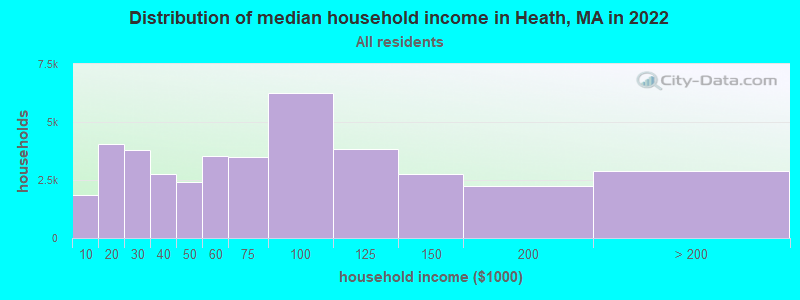
| Heath: | $87,151 |
| MA: | $94,488 |
Estimated per capita income in 2022: $45,142 (it was $24,777 in 2000)
Heath town income, earnings, and wages data
Estimated median house or condo value in 2022: $304,185 (it was $122,400 in 2000)
| Heath: | $304,185 |
| MA: | $534,700 |
Mean prices in 2022: all housing units: $313,377; detached houses: $324,224; townhouses or other attached units: $284,225; in 2-unit structures: $287,978; in 3-to-4-unit structures: $183,938; in 5-or-more-unit structures: $249,762; mobile homes: $62,200
Detailed information about poverty and poor residents in Heath, MA
Compare current foreclosures near Heath, MA:
| Photo | Address | Area | Beds / Baths | Price | Details |
|---|---|---|---|---|---|

|
#1
Elmwood Ave
North Adams, MA 01247
|
2,777 sq. feet
|
3 baths 5 beds |
$215,000
|
show details |

|
#2
Lampblack Rd
Greenfield, MA 01301
|
2,078 sq. feet
|
1 baths 3 beds |
$369,900
|
show details |

|
#3
Route 2
Shelburne Falls, MA 01370
|
- sq. feet
|
3 baths 6 beds |
$229,900
|
show details |

|
#4
Grove St
Adams, MA 01220
|
2,644 sq. feet
|
2 baths 7 beds |
show details | |

|
#5
J St
Turners Falls, MA 01376
|
3,256 sq. feet
|
2 baths 7 beds |
show details | |

|
#6
Franklin St
North Adams, MA 01247
|
1,386 sq. feet
|
1 baths 3 beds |
show details | |

|
#7
North St
North Adams, MA 01247
|
1,164 sq. feet
|
1 baths 3 beds |
show details | |

|
#8
Sabans Rd
Conway, MA 01341
|
1,246 sq. feet
|
2 baths 3 beds |
show details | |

|
#9
Houghton St
North Adams, MA 01247
|
1,614 sq. feet
|
2 baths 4 beds |
show details | |

|
#10
W Mountain Rd
Adams, MA 01220
|
1,173 sq. feet
|
1 baths 3 beds |
show details |
| Photo | Address | Area | Beds / Baths | Price | Details |
|---|---|---|---|---|---|

|
#11
Grove St
Turners Falls, MA 01376
|
2,273 sq. feet
|
1 baths 4 beds |
show details | |

|
#12
J Street
Montague, MA Array
|
3,255 sq. feet
|
2 baths 7 beds |
show details | |

|
#13
5th St
Turners Falls, MA 01376
|
1,683 sq. feet
|
2 baths 4 beds |
show details | |

|
#14
Dell St
Turners Falls, MA 01376
|
720 sq. feet
|
1 baths 1 beds |
show details | |

|
#15
Central St
Turners Falls, MA 01376
|
1,506 sq. feet
|
1 baths 3 beds |
show details | |

|
#16
Franklin St
North Adams, MA 01247
|
1,386 sq. feet
|
1 baths 3 beds |
show details | |

|
#17
Anthony St # B
Adams, MA 01220
|
1,622 sq. feet
|
2 baths 3 beds |
show details | |

|
#18
Houghton St
North Adams, MA 01247
|
3,380 sq. feet
|
3 baths 5 beds |
show details | |

|
#19
Log Plain Rd
Greenfield, MA 01301
|
960 sq. feet
|
1 baths 3 beds |
show details | |

|
#20
E Hoosac St
Adams, MA 01220
|
594 sq. feet
|
1 baths 2 beds |
show details |
| Photo | Address | Area | Beds / Baths | Price | Details |
|---|---|---|---|---|---|

|
#21
North St
North Adams, MA 01247
|
1,164 sq. feet
|
1 baths 3 beds |
show details | |

|
#22
Richmond St
Adams, MA 01220
|
1,920 sq. feet
|
2 baths 4 beds |
show details | |

|
#23
Weber St # 12
Adams, MA 01220
|
1,728 sq. feet
|
2 baths 4 beds |
show details | |

|
#24
Daniels Ct
Adams, MA 01220
|
1,400 sq. feet
|
1 baths 3 beds |
show details | |

|
#25
Valley St
Adams, MA 01220
|
1,680 sq. feet
|
2 baths 4 beds |
show details | |

|
#26
Boyle Rd
Northfield, MA 01354
|
1,500 sq. feet
|
2 baths 3 beds |
show details | |

|
#27
Rte 9
Windsor, MA 01270
|
1,223 sq. feet
|
1 baths 2 beds |
show details | |

|
#28
Mohawk Trl
North Adams, MA 01247
|
1,210 sq. feet
|
1 baths 3 beds |
show details | |

|
#29
Bald Mountain Rd
Bernardston, MA 01337
|
918 sq. feet
|
1 baths 2 beds |
show details | |

|
#30
W Shaft Rd
North Adams, MA 01247
|
1,144 sq. feet
|
1 baths 3 beds |
show details |
| Photo | Address | Area | Beds / Baths | Price | Details |
|---|---|---|---|---|---|

|
#31
Forest Ave
Greenfield, MA 01301
|
1,764 sq. feet
|
1 baths 4 beds |
show details | |

|
#32
Legate Hill Rd
Charlemont, MA 01339
|
2,016 sq. feet
|
2 baths 3 beds |
show details | |

|
#33
Tea St
Charlemont, MA 01339
|
2,829 sq. feet
|
2 baths 6 beds |
show details | |

|
#34
Jacksonville Rd
Colrain, MA 01340
|
1,108 sq. feet
|
1 baths 2 beds |
show details | |

|
#35
Hawley Rd
Ashfield, MA 01330
|
1,008 sq. feet
|
1 baths 3 beds |
show details | |

|
#36
Church Rd
Drury, MA 01343
|
2,560 sq. feet
|
2 baths 4 beds |
show details | |

|
#37
Phelps Rd
North Adams, MA 01247
|
1,286 sq. feet
|
1 baths 4 beds |
show details | |

|
#38
Loop Rd
Savoy, MA 01256
|
1,040 sq. feet
|
1 baths 3 beds |
show details | |

|
#39
French King Hwy
Greenfield, MA 01301
|
1,040 sq. feet
|
1 baths 5 beds |
show details | |

|
#40
Chapman St
Greenfield, MA 01301
|
1,472 sq. feet
|
1 baths 2 beds |
show details |
| Photo | Address | Area | Beds / Baths | Price | Details |
|---|---|---|---|---|---|

|
#41
Shelburne Rd
Greenfield, MA 01301
|
1,382 sq. feet
|
1 baths 2 beds |
show details | |

|
#42
Elm St
Greenfield, MA 01301
|
1,160 sq. feet
|
1 baths 3 beds |
show details | |

|
#43
Garfield St
Greenfield, MA 01301
|
2,260 sq. feet
|
2 baths 4 beds |
show details | |

|
#44
James St
Greenfield, MA 01301
|
2,176 sq. feet
|
2 baths 4 beds |
show details | |

|
#45
Hope St
Greenfield, MA 01301
|
1,619 sq. feet
|
1 baths 3 beds |
show details | |

|
#46
Deerfield St
Greenfield, MA 01301
|
1,496 sq. feet
|
2 baths 3 beds |
show details | |

|
#47
Meridian St
Greenfield, MA 01301
|
768 sq. feet
|
1 baths 2 beds |
show details | |

|
#48
Maple St
Greenfield, MA 01301
|
1,216 sq. feet
|
1 baths 3 beds |
show details | |

|
#49
Hillcrest Dr
Bernardston, MA 01337
|
1,120 sq. feet
|
1 baths 3 beds |
show details | |

|
Check over 1 million property listings on Foreclosure.com!
|
browse all offers | |||

- 68096.3%White alone
- 121.7%Two or more races
- 101.4%Hispanic
- 30.4%Black alone
- 10.1%American Indian alone
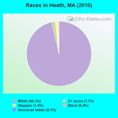
Races in Heath detailed stats: ancestries, foreign born residents, place of birth
 Recent articles from our blog. Our writers, many of them Ph.D. graduates or candidates, create easy-to-read articles on a wide variety of topics.

 | Boston crime thread - all posts go here. (2499 replies) |
| Why is BPS so bad and what should be done to improve it? (589 replies) |
| And then there were two... (758 replies) |
| Bike Routes in Boston + Trip Tips (43 replies) |
| More shootings in Hyde Park (46 replies) |
| Gravestone stolen in Boston as advocates fear escalation in gang dispute (4 replies) |
Latest news from Heath, MA collected exclusively by city-data.com from local newspapers, TV, and radio stations
Ancestries: English (19.5%), Irish (19.0%), Italian (16.4%), French (15.7%), German (14.9%), French Canadian (8.8%).
Current Local Time: EST time zone
Incorporated in 1785
Elevation: 1680 feet
Land area: 24.9 square miles.
Population density: 28 people per square mile (very low).
11 residents are foreign born
| This town: | 1.4% |
| Massachusetts: | 12.2% |
| Heath town: | 1.3% ($1,617) |
| Massachusetts: | 1.3% ($2,336) |
Nearest city with pop. 50,000+: Chicopee, MA  (37.2 miles , pop. 54,653).
Nearest city with pop. 200,000+: Boston, MA (91.6 miles , pop. 589,141).
Nearest city with pop. 1,000,000+: Bronx, NY (138.0 miles , pop. 1,332,650).
Nearest cities:
), ), ), Latitude: 42.68 N, Longitude: 72.82 W
Area code commonly used in this area: 413

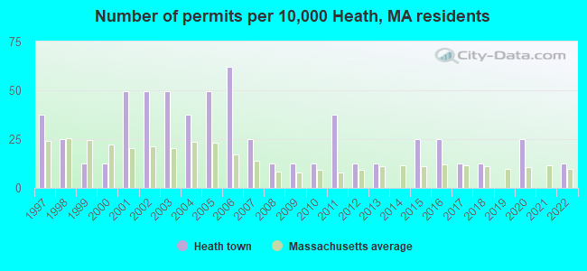
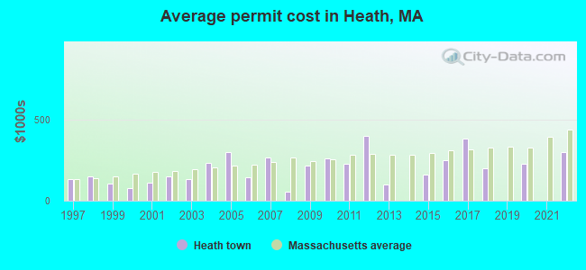
Single-family new house construction building permits:
- 2022: 1 building, cost: $300,000
- 2020: 2 buildings, average cost: $225,000
- 2018: 1 building, cost: $200,000
- 2017: 1 building, cost: $380,000
- 2016: 2 buildings, average cost: $250,000
- 2015: 2 buildings, average cost: $162,600
- 2013: 1 building, cost: $100,000
- 2012: 1 building, cost: $400,000
- 2011: 3 buildings, average cost: $227,700
- 2010: 1 building, cost: $258,000
- 2009: 1 building, cost: $217,900
- 2008: 1 building, cost: $57,400
- 2007: 2 buildings, average cost: $264,000
- 2006: 5 buildings, average cost: $145,300
- 2005: 4 buildings, average cost: $297,400
- 2004: 3 buildings, average cost: $233,100
- 2003: 4 buildings, average cost: $131,300
- 2002: 4 buildings, average cost: $147,900
- 2001: 4 buildings, average cost: $108,000
- 2000: 1 building, cost: $80,400
- 1999: 1 building, cost: $105,600
- 1998: 2 buildings, average cost: $148,700
- 1997: 3 buildings, average cost: $132,100
| Here: | 2.5% |
| Massachusetts: | 3.5% |
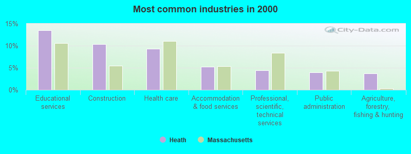
- Educational services (13.4%)
- Construction (10.4%)
- Health care (9.3%)
- Accommodation & food services (5.3%)
- Professional, scientific, technical services (4.4%)
- Public administration (4.0%)
- Agriculture, forestry, fishing & hunting (3.7%)
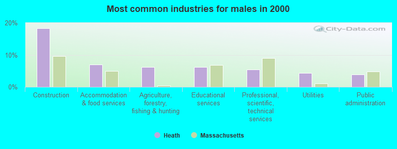
- Construction (18.4%)
- Accommodation & food services (7.0%)
- Agriculture, forestry, fishing & hunting (6.2%)
- Educational services (6.2%)
- Professional, scientific, technical services (5.5%)
- Utilities (4.3%)
- Public administration (3.9%)

- Educational services (22.7%)
- Health care (17.7%)
- Food & beverage stores (7.1%)
- Social assistance (6.6%)
- Public administration (4.0%)
- Used merchandise, gift, novelty, souvenir, other miscellaneous stores (3.0%)
- Professional, scientific, technical services (3.0%)
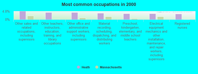
- Other sales and related occupations, including supervisors (4.8%)
- Other teachers, instructors, education, training, and library occupations (4.2%)
- Other office and administrative support workers, including supervisors (4.2%)
- Material recording, scheduling, dispatching, and distributing workers (3.7%)
- Preschool, kindergarten, elementary, and middle school teachers (3.5%)
- Electrical equipment mechanics and other installation, maintenance, and repair workers, including supervisors (3.5%)
- Registered nurses (3.3%)
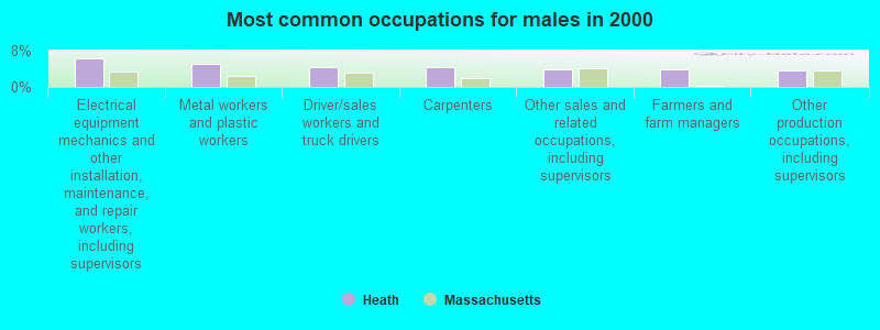
- Electrical equipment mechanics and other installation, maintenance, and repair workers, including supervisors (6.2%)
- Metal workers and plastic workers (5.1%)
- Driver/sales workers and truck drivers (4.3%)
- Carpenters (4.3%)
- Other sales and related occupations, including supervisors (3.9%)
- Farmers and farm managers (3.9%)
- Other production occupations, including supervisors (3.5%)

- Other teachers, instructors, education, training, and library occupations (9.6%)
- Registered nurses (7.6%)
- Other office and administrative support workers, including supervisors (7.6%)
- Other sales and related occupations, including supervisors (6.1%)
- Preschool, kindergarten, elementary, and middle school teachers (5.6%)
- Retail sales workers, except cashiers (5.6%)
- Cashiers (5.1%)
Average climate in Heath, Massachusetts
Based on data reported by over 4,000 weather stations


(lower is better)
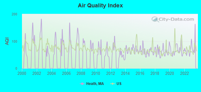
Air Quality Index (AQI) level in 2022 was 65.9. This is about average.
| City: | 65.9 |
| U.S.: | 72.6 |
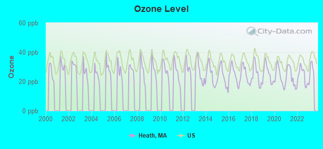
Ozone [ppb] level in 2022 was 23.8. This is better than average. Closest monitor was 12.4 miles away from the city center.
| City: | 23.8 |
| U.S.: | 33.3 |
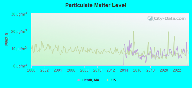
Particulate Matter (PM2.5) [µg/m3] level in 2022 was 6.74. This is better than average. Closest monitor was 12.4 miles away from the city center.
| City: | 6.74 |
| U.S.: | 8.11 |
Tornado activity:
Heath-area historical tornado activity is slightly above Massachusetts state average. It is 20% smaller than the overall U.S. average.
On 8/28/1973, a category F4 (max. wind speeds 207-260 mph) tornado 35.6 miles away from the Heath town center killed 4 people and injured 36 people and caused between $5,000,000 and $50,000,000 in damages.
On 6/9/1953, a category F4 tornado 36.1 miles away from the town center killed 90 people and injured 1228 people and caused between $50,000,000 and $500,000,000 in damages.
Earthquake activity:
Heath-area historical earthquake activity is significantly above Massachusetts state average. It is 69% smaller than the overall U.S. average.On 10/7/1983 at 10:18:46, a magnitude 5.3 (5.1 MB, 5.3 LG, 5.1 ML, Class: Moderate, Intensity: VI - VII) earthquake occurred 116.8 miles away from the city center
On 4/20/2002 at 10:50:47, a magnitude 5.3 (5.3 ML, Depth: 3.0 mi) earthquake occurred 134.2 miles away from the city center
On 4/20/2002 at 10:50:47, a magnitude 5.2 (5.2 MB, 4.2 MS, 5.2 MW, 5.0 MW) earthquake occurred 132.9 miles away from Heath center
On 1/19/1982 at 00:14:42, a magnitude 4.7 (4.5 MB, 4.7 MD, 4.5 LG, Class: Light, Intensity: IV - V) earthquake occurred 83.7 miles away from the city center
On 10/16/2012 at 23:12:25, a magnitude 4.7 (4.7 ML, Depth: 10.0 mi) earthquake occurred 126.2 miles away from the city center
On 6/17/1991 at 08:53:16, a magnitude 4.1 (4.0 MB, 4.0 LG, Depth: 3.1 mi) earthquake occurred 94.7 miles away from Heath center
Magnitude types: regional Lg-wave magnitude (LG), body-wave magnitude (MB), duration magnitude (MD), local magnitude (ML), surface-wave magnitude (MS), moment magnitude (MW)
Natural disasters:
The number of natural disasters in Franklin County (20) is greater than the US average (15).Major Disasters (Presidential) Declared: 9
Emergencies Declared: 10
Causes of natural disasters: Floods: 5, Storms: 5, Hurricanes: 4, Snowstorms: 4, Winter Storms: 3, Blizzards: 2, Snows: 2, Snowfall: 1, Tropical Storm: 1, Wind: 1, Other: 1 (Note: some incidents may be assigned to more than one category).
Hospitals and medical centers near Heath:
- ANCHORAGE NURSING HOME (Nursing Home, about 10 miles away; SHELBURNE, MA)
- CHARLENE MANOR EXTENDED CARE FACILITY (Nursing Home, about 12 miles away; GREENFIELD, MA)
- HOSPICE OF FRANKLIN COUNTY, INC (Hospital, about 12 miles away; GREENFIELD, MA)
- FRANKLIN CENTER (Nursing Home, about 12 miles away; GREENFIELD, MA)
- BUCKLEY-GREENFIELD HEALTHCARE CENTER (Nursing Home, about 13 miles away; GREENFIELD, MA)
- HOME CARE PRN INC (Home Health Center, about 13 miles away; GREENFIELD, MA)
- GENTIVA HEALTH SERVICES (Home Health Center, about 13 miles away; GREENFIELD, MA)
Operable nuclear power plant near Heath:
- 17 miles: Vermont Yankee in Vernon, VT.
Colleges/universities with over 2000 students nearest to Heath:
- Williams College (about 20 miles; Williamstown, MA; Full-time enrollment: 2,141)
- University of Massachusetts-Amherst (about 26 miles; Amherst, MA; FT enrollment: 26,583)
- Smith College (about 27 miles; Northampton, MA; FT enrollment: 3,549)
- Mount Holyoke College (about 32 miles; South Hadley, MA; FT enrollment: 2,573)
- Keene State College (about 33 miles; Keene, NH; FT enrollment: 5,098)
- Holyoke Community College (about 35 miles; Holyoke, MA; FT enrollment: 4,911)
- Westfield State University (about 38 miles; Westfield, MA; FT enrollment: 5,548)
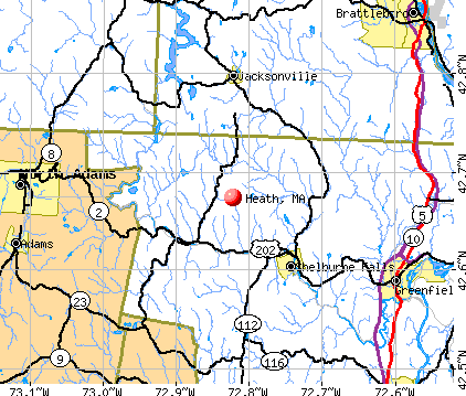
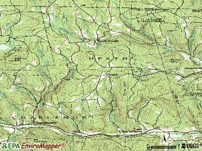
Points of interest:
Notable location: Heath Fire Department (A). Display/hide its location on the map
Cemeteries: South Cemetery (1), Center Cemetery (2), Maple Grove Cemetery (3). Display/hide their locations on the map
Reservoir: Davenport Brook Reservoir (A). Display/hide its location on the map
Streams, rivers, and creeks: West Branch Brook (A), Dickenson Brook (B), Davenport Brook (C), Carley Brook (D), Burrington Brook (E), Underwood Brook (F), Kinsman Brook (G), Heath Brook (H). Display/hide their locations on the map
Birthplace of: William W. Snow - Politician.
| This town: | 2.3 people |
| Massachusetts: | 2.5 people |
| This town: | 65.6% |
| Whole state: | 63.0% |
| This town: | 9.6% |
| Whole state: | 7.0% |
Likely homosexual households (counted as self-reported same-sex unmarried-partner households)
- Lesbian couples: 0.3% of all households
- Gay men: 0.7% of all households
| This town: | 9.4% |
| Whole state: | 9.3% |
| This town: | 4.2% |
| Whole state: | 4.4% |
For population 15 years and over in Heath:
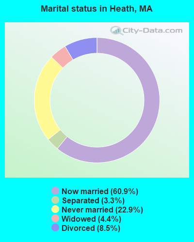
- Never married: 22.9%
- Now married: 60.9%
- Separated: 3.3%
- Widowed: 4.4%
- Divorced: 8.5%
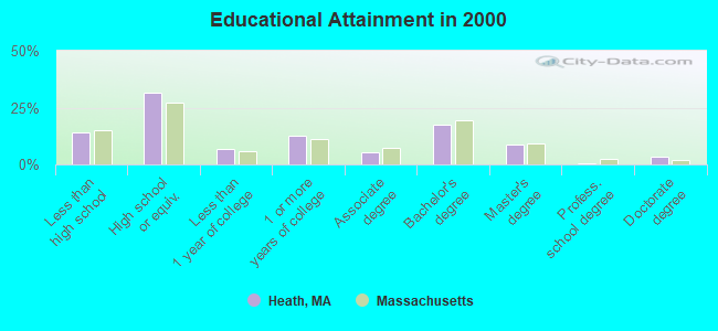
For population 25 years and over in Heath:
- High school or higher: 85.7%
- Bachelor's degree or higher: 29.5%
- Graduate or professional degree: 12.2%
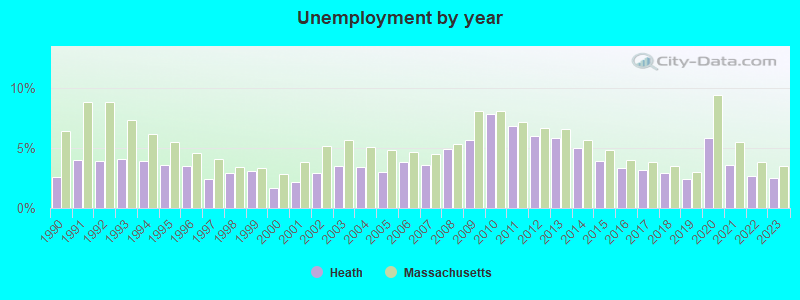
- Unemployed: 5.2%
- Mean travel time to work (commute): 35.5 minutes
| Here: | 11.1 |
| Massachusetts average: | 13.1 |


Graphs represent county-level data. Detailed 2008 Election Results
Religion statistics for Heath, MA (based on Franklin County data)


| Religion | Adherents | Congregations |
|---|---|---|
| Catholic | 16,509 | 15 |
| Mainline Protestant | 4,617 | 38 |
| Evangelical Protestant | 2,079 | 20 |
| Other | 1,580 | 21 |
| None | 46,587 | - |
Food Environment Statistics:
| Here: | 3.63 / 10,000 pop. |
| Massachusetts: | 1.98 / 10,000 pop. |
| This county: | 0.14 / 10,000 pop. |
| Massachusetts: | 0.05 / 10,000 pop. |
| This county: | 1.67 / 10,000 pop. |
| Massachusetts: | 2.22 / 10,000 pop. |
| Franklin County: | 3.21 / 10,000 pop. |
| State: | 1.77 / 10,000 pop. |
| Here: | 8.10 / 10,000 pop. |
| State: | 8.76 / 10,000 pop. |
| Franklin County: | 7.5% |
| Massachusetts: | 8.1% |
| Franklin County: | 22.2% |
| Massachusetts: | 22.5% |
| This county: | 15.1% |
| Massachusetts: | 16.5% |
Strongest AM radio stations in Heath:
- WNNZ (640 AM; 50 kW; WESTFIELD, MA; Owner: CLEAR CHANNEL BROADCASTING LICENSES, INC.)
- WIZZ (1520 AM; daytime; 10 kW; GREENFIELD, MA; Owner: P. & M. RADIO, LLC)
- WCRN (830 AM; 50 kW; WORCESTER, MA; Owner: CARTER BROADCASTING CORPORATION)
- WGY (810 AM; 50 kW; SCHENECTADY, NY; Owner: CLEAR CHANNEL BROADCASTING LICENSES, INC.)
- WVNE (760 AM; daytime; 25 kW; LEICESTER, MA; Owner: BLOUNT MASSCOM, INC.)
- WTIC (1080 AM; 50 kW; HARTFORD, CT; Owner: INFINITY RADIO OPERATIONS INC.)
- WPTR (1540 AM; 50 kW; ALBANY, NY; Owner: KIMTRON, INC.)
- WRKO (680 AM; 50 kW; BOSTON, MA; Owner: ENTERCOM BOSTON LICENSE, LLC)
- WEEI (850 AM; 50 kW; BOSTON, MA; Owner: ENTERCOM BOSTON LICENSE, LLC)
- WALE (990 AM; 50 kW; GREENVILLE, RI; Owner: NORTH AMERICAN BROADCASTING CO., INC.)
- WKOX (1200 AM; 50 kW; FRAMINGHAM, MA; Owner: CAPSTAR TX LIMITED PARTNERSHIP)
- WHYN (560 AM; 5 kW; SPRINGFIELD, MA; Owner: CLEAR CHANNEL BROADCASTING LICENSES, INC.)
- WBIX (1060 AM; 40 kW; NATICK, MA; Owner: LANGER BROADCASTING CORPORATION)
Strongest FM radio stations in Heath:
- WAMC-FM (90.3 FM; ALBANY, NY; Owner: WAMC)
- WPVQ (95.3 FM; GREENFIELD, MA; Owner: GREAT NORTHERN RADIO, L.L.C.)
- WVAY (100.7 FM; WILMINGTON, VT; Owner: GREAT NORTHERN RADIO, L.L.C.)
- WRSY (101.5 FM; MARLBORO, VT; Owner: GREAT NORTHERN RADIO, L.L.C.)
- WEQX (102.7 FM; MANCHESTER, VT; Owner: NORTHSHIRE COMMUNICATIONS, INC.)
- WJAN (95.1 FM; SUNDERLAND, VT; Owner: 6 JOHNSON ROAD LICENSES, INC.)
- WHAI (98.3 FM; GREENFIELD, MA; Owner: SAGA COMMUNICATIONS OF NEW ENGLAND, LLC)
- WMNB (100.1 FM; NORTH ADAMS, MA; Owner: BERKSHIRE BROADCASTING CO., INC.)
- WRSI (93.9 FM; TURNERS FALLS, MA; Owner: GREAT NORTHERN RADIO, LLC)
- WKVT-FM (92.7 FM; BRATTLEBORO, VT; Owner: SAGA COMMUNICATIONS OF NEW ENGLAND, LLC)
- WYRY (104.9 FM; HINSDALE, NH; Owner: TRI-VALLEY BROADCASTING CORPORATION)
- WZEC (97.5 FM; HOOSICK FALLS, NY; Owner: GREAT NORTHERN RADIO, LLC)
- WCMK (91.9 FM; PUTNEY, VT; Owner: CHRISTIAN MINISTRIES INC)
- WFCR (88.5 FM; AMHERST, MA; Owner: UNIVERSITY OF MASSACHUSETTS)
- WHDQ (106.1 FM; CLAREMONT, NH; Owner: GREAT NORTHERN RADIO, L.L.C.)
- WVPR (89.5 FM; WINDSOR, VT; Owner: VERMONT PUBLIC RADIO)
- WJJR (98.1 FM; RUTLAND, VT; Owner: 6 JOHNSON ROAD LICENSES, INC.)
- WZRT (97.1 FM; RUTLAND, VT; Owner: CAPSTAR TX LIMITED PARTNERSHIP)
- WHYN-FM (93.1 FM; SPRINGFIELD, MA; Owner: CLEAR CHANNEL BROADCASTING LICENSES, INC.)
- WEBK (105.3 FM; KILLINGTON, VT; Owner: 6 JOHNSON ROAD LICENSES, INC.)
TV broadcast stations around Heath:
- W35BK (Channel 35; PLAINFIELD, MA; Owner: LYDIA SYLVANE STOCKWELL)
- WYDN (Channel 48; WORCESTER, MA; Owner: EDUCATIONAL PUBLIC TV CORPORATION)
- WCDC-TV (Channel 19; ADAMS, MA; Owner: YOUNG BROADCASTING OF ALBANY, INC.)
- W38DL (Channel 38; ADAMS, ETC., MA; Owner: WNYT-TV, LLC)
Heath fatal accident list:
Sep 23, 2015 09:40 PM, Dell Road, Lat: 77.777700, Lon: 777.777700, Vehicles: 1, Persons: 1, Fatalities: 1
Jul 31, 2004 06:00 PM, Sr-8a, Vehicles: 2, Persons: 3, Fatalities: 1
Dec 28, 1987 03:20 PM, No 9 Road, Vehicles: 1, Persons: 2, Fatalities: 1
- National Bridge Inventory (NBI) Statistics
- 5Number of bridges
- 16ft / 5.0mTotal length
- $3,947,000Total costs
- 992Total average daily traffic
- 77Total average daily truck traffic
- 727Total future (year 2032) average daily traffic
FCC Registered Amateur Radio Licenses:
3- Call Sign: N1AMW, Grant Date: 04/12/1994, Expiration Date: 04/12/2004, Cancellation Date: 04/14/2006, Registrant: Robert T Markert, Hosmer Rd, Heath, MA 01346
- Call Sign: W1HPQ, Grant Date: 11/28/1995, Expiration Date: 11/28/2005, Cancellation Date: 11/29/2007, Registrant: Russell E Johnson, South Rd, Heath, MA 01346
- Call Sign: AB1JX, Licensee ID: L01448699, Grant Date: 09/11/2018, Expiration Date: 12/01/2028, Certifier: Alan R Corey, Registrant: Alan R Corey, 12 Schoolhouse Rd, Heath, MA 01346
FAA Registered Aircraft:
1- Aircraft: BURGESS GEORGE LOUIS OSPREY-II (Category: Amphibian, Seats: 2, Weight: Up to 12,499 Pounds), Engine: Reciprocating
N-Number: 6190G, N6190G, N-6190G, Serial Number: 290, Certificate Issue Date: 07/06/2018
Registrant (Individual): Erich J Holan, Po Box 718, Heath, MA 01346
Deregistered: Cancel Date: 10/22/1975, Exported to: Canada
2002 - 2018 National Fire Incident Reporting System (NFIRS) incidents
- Fire incident types reported to NFIRS in Heath, MA
- 11169.4%Structure Fires
- 3320.6%Outside Fires
- 116.9%Mobile Property/Vehicle Fires
- 53.1%Other
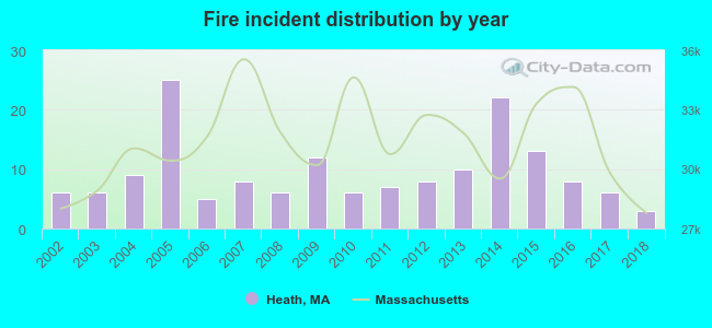 Based on the data from the years 2002 - 2018 the average number of fire incidents per year is 9. The highest number of fires - 25 took place in 2005, and the least - 3 in 2018. The data has a decreasing trend.
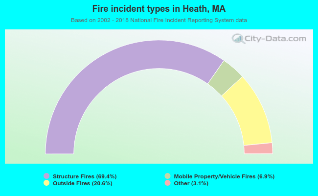 When looking into fire subcategories, the most reports belonged to: Structure Fires (69.4%), and Outside Fires (20.6%).
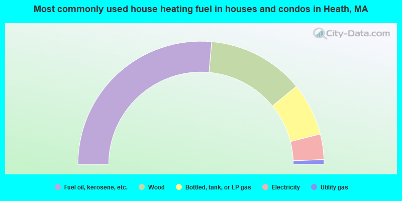
- 52.8%Fuel oil, kerosene, etc.
- 25.4%Wood
- 13.9%Bottled, tank, or LP gas
- 6.7%Electricity
- 1.2%Utility gas
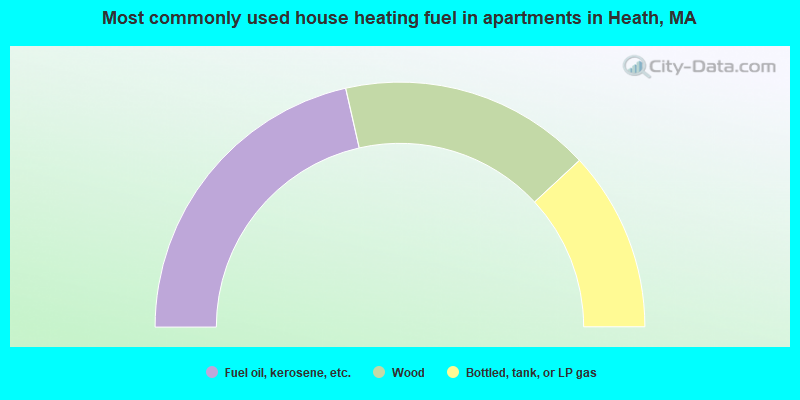
- 42.9%Fuel oil, kerosene, etc.
- 33.3%Wood
- 23.8%Bottled, tank, or LP gas
Heath compared to Massachusetts state average:
- Median house value below state average.
- Unemployed percentage below state average.
- Black race population percentage significantly below state average.
- Hispanic race population percentage significantly below state average.
- Median age significantly above state average.
- Foreign-born population percentage significantly below state average.
- Renting percentage significantly below state average.
- Length of stay since moving in significantly above state average.
- Number of rooms per house significantly below state average.
- House age significantly below state average.
- Number of college students below state average.