Lonsdale, Minnesota

Submit your own pictures of this city and show them to the world
- OSM Map
- General Map
- Google Map
- MSN Map
Population change since 2000: +229.3%
| Males: 2,559 | |
| Females: 2,351 |
| Median resident age: | 30.3 years |
| Minnesota median age: | 39.0 years |
Zip codes: 55046.
| Lonsdale: | $92,957 |
| MN: | $82,338 |
Estimated per capita income in 2022: $32,499 (it was $20,368 in 2000)
Lonsdale city income, earnings, and wages data
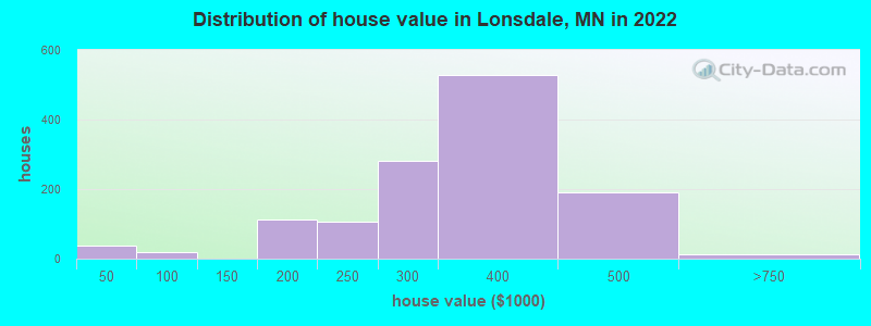
Estimated median house or condo value in 2022: $333,377 (it was $114,800 in 2000)
| Lonsdale: | $333,377 |
| MN: | $314,600 |
Mean prices in 2022: all housing units: $331,259; detached houses: $330,535; townhouses or other attached units: $275,170
Median gross rent in 2022: $1,180.
Detailed information about poverty and poor residents in Lonsdale, MN


Compare current foreclosures near Lonsdale, MN:
| Photo | Address | Area | Beds / Baths | Price | Details |
|---|---|---|---|---|---|

|
#1
Dogwood St NE
Lonsdale, MN 55046
|
1,580 sq. feet
|
2 baths 3 beds |
show details | |

|
#2
Elm St NE
Lonsdale, MN 55046
|
1,104 sq. feet
|
1 baths 3 beds |
show details | |

|
#3
Delaware St SW
Lonsdale, MN 55046
|
1,104 sq. feet
|
1 baths 2 beds |
show details | |

|
#4
Harvest Dr SW
Lonsdale, MN 55046
|
1,864 sq. feet
|
2 baths 3 beds |
show details | |

|
#5
Pond View Dr SE
Lonsdale, MN 55046
|
- sq. feet
|
- baths - beds |
show details | |

|
#6
11th Ave NE
Lonsdale, MN 55046
|
- sq. feet
|
- baths - beds |
show details | |

|
#7
Hickory St NE
Lonsdale, MN 55046
|
- sq. feet
|
- baths - beds |
show details | |

|
#8
Dogwood St NE
Lonsdale, MN 55046
|
- sq. feet
|
- baths - beds |
show details | |

|
#9
15th Ave SE
Lonsdale, MN 55046
|
- sq. feet
|
- baths - beds |
show details | |

|
#10
Harvest Dr SW
Lonsdale, MN 55046
|
- sq. feet
|
- baths - beds |
show details |
| Photo | Address | Area | Beds / Baths | Price | Details |
|---|---|---|---|---|---|

|
#11
4th Ave NE
Lonsdale, MN 55046
|
- sq. feet
|
- baths - beds |
show details | |

|
#12
Judge Ave
Lonsdale, MN 55046
|
- sq. feet
|
- baths - beds |
show details | |

|
#13
Willow Creek Dr SE
Lonsdale, MN 55046
|
- sq. feet
|
- baths - beds |
show details | |

|
#14
Fairfax Way
Faribault, MN 55021
|
1,373 sq. feet
|
2 baths 2 beds |
$394,900
|
show details |

|
#15
Bixby Ave
Faribault, MN 55021
|
1,522 sq. feet
|
2 baths 3 beds |
$319,900
|
show details |

|
#16
Highview Ave
Lakeville, MN 55044
|
1,468 sq. feet
|
1 baths 4 beds |
show details | |

|
#17
7th Ave SW
Faribault, MN 55021
|
1,058 sq. feet
|
1 baths 2 beds |
show details | |

|
#18
Crosswind Ct
Lakeville, MN 55044
|
4,010 sq. feet
|
5 baths 4 beds |
show details | |

|
#19
3rd St NW
Faribault, MN 55021
|
2,620 sq. feet
|
2 baths 5 beds |
show details | |

|
#20
Central Ave N
Faribault, MN 55021
|
1,175 sq. feet
|
1 baths 3 beds |
show details |
| Photo | Address | Area | Beds / Baths | Price | Details |
|---|---|---|---|---|---|

|
#21
230th St W
Faribault, MN 55021
|
1,334 sq. feet
|
3 baths 3 beds |
show details | |

|
#22
Heath Ave
Lakeville, MN 55044
|
2,372 sq. feet
|
3 baths 5 beds |
show details | |

|
#23
Anna Ct
New Market, MN 55054
|
3,532 sq. feet
|
3 baths 5 beds |
show details | |

|
#24
Jutland Pl
Lakeville, MN 55044
|
1,654 sq. feet
|
3 baths 5 beds |
show details | |

|
#25
Maple Ct
Northfield, MN 55057
|
2,821 sq. feet
|
1 baths 4 beds |
show details | |

|
#26
Mckinley Dr
Northfield, MN 55057
|
1,064 sq. feet
|
2 baths 3 beds |
show details | |

|
#27
Elianna Dr
Northfield, MN 55057
|
1,411 sq. feet
|
1 baths 3 beds |
show details | |

|
#28
Linden St S
Northfield, MN 55057
|
960 sq. feet
|
1 baths 3 beds |
show details | |

|
#29
1st Ave NW
Faribault, MN 55021
|
720 sq. feet
|
1 baths 2 beds |
show details | |

|
#30
6th St NW
Faribault, MN 55021
|
1,568 sq. feet
|
2 baths 3 beds |
show details |
| Photo | Address | Area | Beds / Baths | Price | Details |
|---|---|---|---|---|---|

|
#31
Birn Hill Dr
Faribault, MN 55021
|
974 sq. feet
|
1 baths 4 beds |
show details | |

|
#32
Prairie Ave SW
Faribault, MN 55021
|
892 sq. feet
|
1 baths 3 beds |
show details | |

|
#33
7th Ave SW
Faribault, MN 55021
|
1,574 sq. feet
|
2 baths 5 beds |
show details | |

|
#34
4th Ave NW
Faribault, MN 55021
|
1,456 sq. feet
|
1 baths 3 beds |
show details | |

|
#35
15 1/2 St NW
Faribault, MN 55021
|
1,750 sq. feet
|
1 baths 3 beds |
show details | |

|
#36
2nd Ave NW
Faribault, MN 55021
|
1,939 sq. feet
|
1 baths 4 beds |
show details | |

|
#37
Burr Oak Ln SE
Prior Lake, MN 55372
|
2,152 sq. feet
|
3 baths 4 beds |
show details | |

|
#38
7th Ave SW
Faribault, MN 55021
|
1,344 sq. feet
|
1 baths 4 beds |
show details | |

|
#39
Fawn Meadow Curv SE
Prior Lake, MN 55372
|
1,135 sq. feet
|
2 baths 2 beds |
show details | |

|
#40
Westwood Dr SW
Faribault, MN 55021
|
2,092 sq. feet
|
2 baths 3 beds |
show details |
| Photo | Address | Area | Beds / Baths | Price | Details |
|---|---|---|---|---|---|

|
#41
Woodside Rd SE
Prior Lake, MN 55372
|
1,280 sq. feet
|
2 baths 4 beds |
show details | |

|
#42
Kildeer Ln SE
Prior Lake, MN 55372
|
1,850 sq. feet
|
3 baths 5 beds |
show details | |

|
#43
S Trail Cir
Faribault, MN 55021
|
1,019 sq. feet
|
1 baths 3 beds |
show details | |

|
#44
Crossandra Cir SE
Prior Lake, MN 55372
|
1,617 sq. feet
|
3 baths 4 beds |
show details | |

|
#45
Summer Ln
Faribault, MN 55021
|
1,696 sq. feet
|
2 baths 4 beds |
show details | |

|
#46
Timber Crest Dr SE
Prior Lake, MN 55372
|
774 sq. feet
|
2 baths 2 beds |
show details | |

|
#47
Mill St
Jordan, MN 55352
|
1,538 sq. feet
|
1 baths 4 beds |
show details | |

|
#48
Timber Crest Dr SE
Prior Lake, MN 55372
|
774 sq. feet
|
2 baths 2 beds |
show details | |

|
#49
Cross St SW
Prior Lake, MN 55372
|
1,457 sq. feet
|
3 baths 3 beds |
show details | |

|
Check over 1 million property listings on Foreclosure.com!
|
browse all offers | |||


- 4,32690.8%White alone
- 1593.3%Hispanic
- 1423.0%Asian alone
- 360.8%Two or more races
- 230.5%Black alone
Races in Lonsdale detailed stats: ancestries, foreign born residents, place of birth
Type |
2015 |
2016 |
2017 |
2018 |
2019 |
2020 |
2021 |
2022 |
|---|---|---|---|---|---|---|---|---|
| Murders (per 100,000) | 0 (0.0) | 0 (0.0) | 0 (0.0) | 0 (0.0) | 0 (0.0) | 0 (0.0) | 0 (0.0) | 0 (0.0) |
| Rapes (per 100,000) | 0 (0.0) | 1 (25.8) | 1 (25.4) | 0 (0.0) | 1 (24.1) | 1 (23.4) | 0 (0.0) | 1 (20.4) |
| Robberies (per 100,000) | 0 (0.0) | 0 (0.0) | 0 (0.0) | 0 (0.0) | 0 (0.0) | 0 (0.0) | 0 (0.0) | 0 (0.0) |
| Assaults (per 100,000) | 1 (26.1) | 0 (0.0) | 0 (0.0) | 0 (0.0) | 0 (0.0) | 1 (23.4) | 0 (0.0) | 1 (20.4) |
| Burglaries (per 100,000) | 7 (182.8) | 1 (25.8) | 2 (50.9) | 2 (49.5) | 1 (24.1) | 10 (234.2) | 3 (68.7) | 2 (40.7) |
| Thefts (per 100,000) | 25 (652.7) | 16 (413.1) | 11 (279.8) | 9 (222.9) | 13 (313.9) | 26 (609.0) | 11 (251.9) | 11 (224.1) |
| Auto thefts (per 100,000) | 1 (26.1) | 4 (103.3) | 0 (0.0) | 0 (0.0) | 1 (24.1) | 0 (0.0) | 1 (22.9) | 0 (0.0) |
| Arson (per 100,000) | 0 (0.0) | 0 (0.0) | 0 (0.0) | 0 (0.0) | 0 (0.0) | 0 (0.0) | 0 (0.0) | 2 (40.7) |
| City-Data.com crime index | 46.2 | 47.3 | 35.1 | 12.4 | 35.5 | 64.2 | 16.7 | 32.2 |
The City-Data.com crime index weighs serious crimes and violent crimes more heavily. Higher means more crime, U.S. average is 246.1. It adjusts for the number of visitors and daily workers commuting into cities.
Crime rate in Lonsdale detailed stats: murders, rapes, robberies, assaults, burglaries, thefts, arson
Full-time law enforcement employees in 2021, including police officers: 8 (7 officers - 7 male; 0 female).
| Officers per 1,000 residents here: | 1.60 |
| Minnesota average: | 1.76 |
 Recent articles from our blog. Our writers, many of them Ph.D. graduates or candidates, create easy-to-read articles on a wide variety of topics.


 | East Bethel MN (1 reply) |
| Our scout trip to the TC's is set! SO fired up!! (73 replies) |
| commuting from prescott to edina, and more (6 replies) |
| Best area on a low budget? (12 replies) |
| Relocating from Fla to Minnesota (74 replies) |
| Scout trip to MSP in the books.....now the decision. (12 replies) |
Latest news from Lonsdale, MN collected exclusively by city-data.com from local newspapers, TV, and radio stations
Ancestries: German (20.9%), Czech (16.7%), American (10.3%), Swedish (8.3%), Norwegian (6.7%), Czechoslovakian (3.2%).
Current Local Time: CST time zone
Incorporated in 1903
Land area: 1.32 square miles.
Population density: 3,712 people per square mile (average).

79 residents are foreign born
| This city: | 1.7% |
| Minnesota: | 8.5% |
Median real estate property taxes paid for housing units with mortgages in 2022: $3,367 (1.0%)
Median real estate property taxes paid for housing units with no mortgage in 2022: $3,581 (1.0%)
Nearest city with pop. 50,000+: Burnsville, MN  (20.5 miles , pop. 60,220).
Nearest city with pop. 200,000+: Minneapolis, MN (34.5 miles , pop. 382,618).
Nearest city with pop. 1,000,000+: Chicago, IL (342.7 miles , pop. 2,896,016).
Nearest cities:
), ), ), Latitude: 44.48 N, Longitude: 93.43 W
Area code: 507
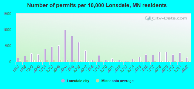
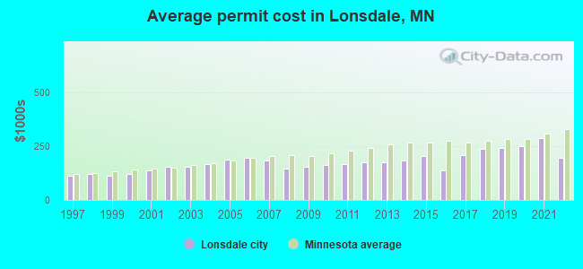
Single-family new house construction building permits:
- 2022: 21 buildings, average cost: $196,900
- 2021: 43 buildings, average cost: $288,800
- 2020: 34 buildings, average cost: $248,900
- 2019: 46 buildings, average cost: $242,400
- 2018: 45 buildings, average cost: $237,300
- 2017: 32 buildings, average cost: $208,600
- 2016: 35 buildings, average cost: $135,900
- 2015: 23 buildings, average cost: $206,900
- 2014: 14 buildings, average cost: $182,100
- 2013: 3 buildings, average cost: $176,500
- 2012: 9 buildings, average cost: $174,500
- 2011: 15 buildings, average cost: $169,100
- 2010: 9 buildings, average cost: $163,900
- 2009: 30 buildings, average cost: $155,600
- 2008: 9 buildings, average cost: $146,300
- 2007: 52 buildings, average cost: $181,900
- 2006: 91 buildings, average cost: $198,100
- 2005: 120 buildings, average cost: $189,800
- 2004: 149 buildings, average cost: $167,200
- 2003: 76 buildings, average cost: $155,900
- 2002: 71 buildings, average cost: $155,900
- 2001: 59 buildings, average cost: $135,900
- 2000: 34 buildings, average cost: $119,600
- 1999: 38 buildings, average cost: $112,700
- 1998: 27 buildings, average cost: $119,600
- 1997: 18 buildings, average cost: $112,900
| Here: | 2.5% |
| Minnesota: | 2.6% |
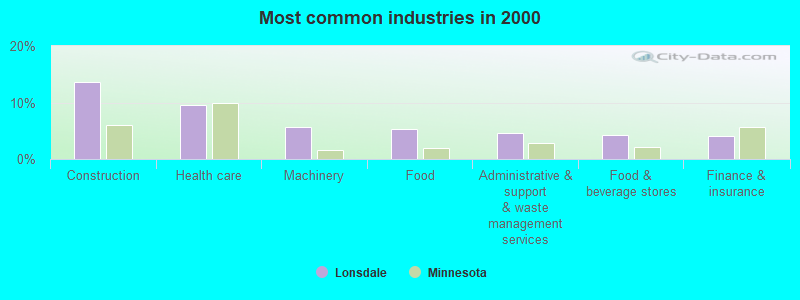
- Construction (13.7%)
- Health care (9.5%)
- Machinery (5.6%)
- Food (5.3%)
- Administrative & support & waste management services (4.5%)
- Food & beverage stores (4.3%)
- Finance & insurance (4.0%)
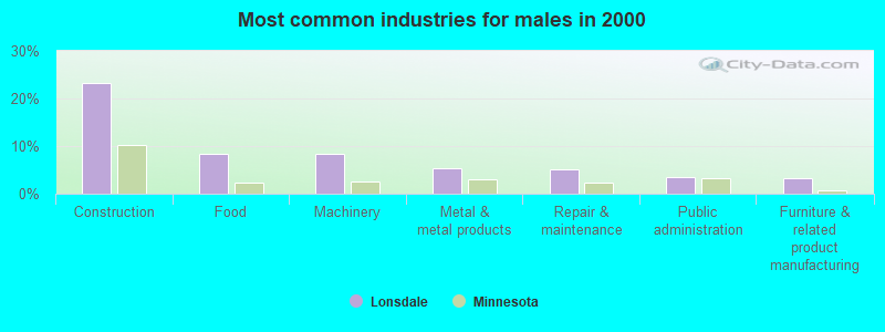
- Construction (23.2%)
- Food (8.3%)
- Machinery (8.3%)
- Metal & metal products (5.3%)
- Repair & maintenance (5.0%)
- Public administration (3.4%)
- Furniture & related product manufacturing (3.2%)
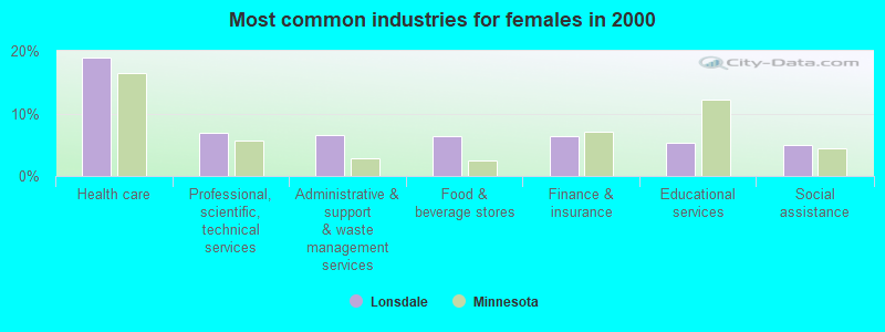
- Health care (18.9%)
- Professional, scientific, technical services (6.8%)
- Administrative & support & waste management services (6.6%)
- Food & beverage stores (6.3%)
- Finance & insurance (6.3%)
- Educational services (5.2%)
- Social assistance (5.0%)
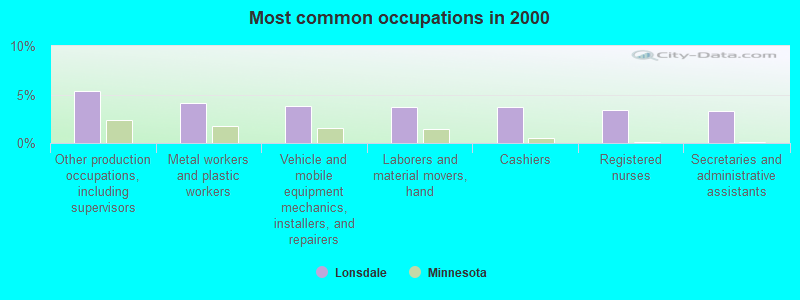
- Other production occupations, including supervisors (5.4%)
- Metal workers and plastic workers (4.2%)
- Vehicle and mobile equipment mechanics, installers, and repairers (3.8%)
- Laborers and material movers, hand (3.7%)
- Cashiers (3.7%)
- Registered nurses (3.4%)
- Secretaries and administrative assistants (3.3%)
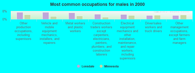
- Other production occupations, including supervisors (7.1%)
- Vehicle and mobile equipment mechanics, installers, and repairers (7.1%)
- Metal workers and plastic workers (6.7%)
- Construction traders workers except carpenters, electricians, painters, plumbers, and construction laborers (5.0%)
- Electrical equipment mechanics and other installation, maintenance, and repair workers, including supervisors (4.8%)
- Driver/sales workers and truck drivers (3.9%)
- Other management occupations, except farmers and farm managers (3.9%)

- Secretaries and administrative assistants (7.1%)
- Registered nurses (6.8%)
- Other office and administrative support workers, including supervisors (6.3%)
- Cashiers (5.0%)
- Health technologists and technicians (4.7%)
- Bookkeeping, accounting, and auditing clerks (3.9%)
- Preschool, kindergarten, elementary, and middle school teachers (3.7%)
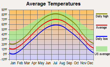
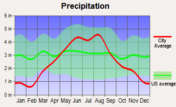
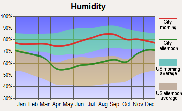
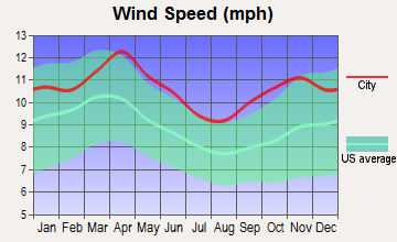
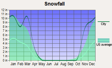
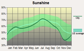
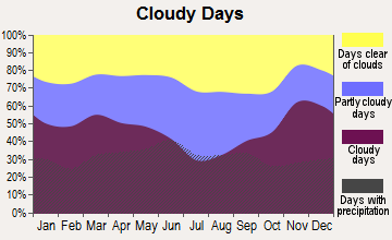
Average climate in Lonsdale, Minnesota
Based on data reported by over 4,000 weather stations
|
|

(lower is better)
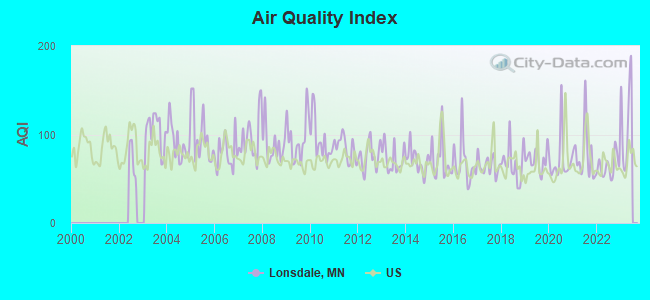
Air Quality Index (AQI) level in 2022 was 64.0. This is about average.
| City: | 64.0 |
| U.S.: | 72.6 |
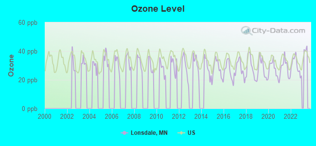
Ozone [ppb] level in 2022 was 29.9. This is about average. Closest monitor was 20.6 miles away from the city center.
| City: | 29.9 |
| U.S.: | 33.3 |
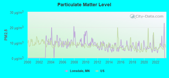
Particulate Matter (PM2.5) [µg/m3] level in 2022 was 6.60. This is better than average. Closest monitor was 20.3 miles away from the city center.
| City: | 6.60 |
| U.S.: | 8.11 |
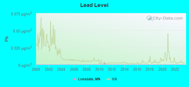
Lead (Pb) [µg/m3] level in 2010 was 0.00088. This is significantly better than average. Closest monitor was 15.1 miles away from the city center.
| City: | 0.00088 |
| U.S.: | 0.00931 |
Tornado activity:
Lonsdale-area historical tornado activity is slightly above Minnesota state average. It is 39% greater than the overall U.S. average.
On 4/30/1967, a category F4 (max. wind speeds 207-260 mph) tornado 25.0 miles away from the Lonsdale city center killed 6 people and injured 22 people and caused between $5,000,000 and $50,000,000 in damages.
On 5/6/1965, a category F4 tornado 26.0 miles away from the city center killed 3 people and injured 175 people and caused between $5,000,000 and $50,000,000 in damages.
Earthquake activity:
Lonsdale-area historical earthquake activity is significantly above Minnesota state average. It is 68% greater than the overall U.S. average.On 7/9/1975 at 14:54:15, a magnitude 4.6 (4.6 MB, Class: Light, Intensity: IV - V) earthquake occurred 151.7 miles away from Lonsdale center
On 6/5/1993 at 01:24:53, a magnitude 4.1 (4.1 LG, Depth: 6.2 mi) earthquake occurred 162.4 miles away from Lonsdale center
On 3/4/1983 at 06:32:18, a magnitude 4.6 (4.4 MB, 4.6 LG, 4.4 ML) earthquake occurred 296.2 miles away from the city center
On 10/20/1995 at 15:57:18, a magnitude 3.7 (3.7 LG, Depth: 3.1 mi, Class: Light, Intensity: II - III) earthquake occurred 190.4 miles away from the city center
On 11/3/2002 at 20:41:56, a magnitude 4.3 (4.3 MB, Depth: 3.1 mi) earthquake occurred 298.1 miles away from the city center
On 2/9/1994 at 08:45:35, a magnitude 3.1 (3.1 LG, Depth: 3.1 mi) earthquake occurred 85.1 miles away from Lonsdale center
Magnitude types: regional Lg-wave magnitude (LG), body-wave magnitude (MB), local magnitude (ML)
Natural disasters:
The number of natural disasters in Rice County (12) is smaller than the US average (15).Major Disasters (Presidential) Declared: 10
Emergencies Declared: 1
Causes of natural disasters: Floods: 7, Storms: 7, Tornadoes: 3, Winds: 2, Hurricane: 1, Ice Storm: 1, Landslide: 1, Mudslide: 1, Other: 1 (Note: some incidents may be assigned to more than one category).
Hospitals and medical centers near Lonsdale:
- LUTHERAN HOME OF MONTGOMERY,THE (Nursing Home, about 8 miles away; MONTGOMERY, MN)
- MAYO CLINIC HEALTH SYSTEM - NEW PRAGUE Critical Access Hospitals (about 9 miles away; NEW PRAGUE, MN)
- MALA STRANA HEALTH CARE CENTER (Nursing Home, about 9 miles away; NEW PRAGUE, MN)
- MALA STRANA INC (Nursing Home, about 9 miles away; NEW PRAGUE, MN)
- NORTHFIELD CARE CENTER INC (Nursing Home, about 13 miles away; NORTHFIELD, MN)
- NORTHFIELD HOSPITAL Acute Care Hospitals (about 13 miles away; NORTHFIELD, MN)
- HOME CARE LINK (Home Health Center, about 13 miles away; NORTHFIELD, MN)
Colleges/universities with over 2000 students nearest to Lonsdale:
- St Olaf College (about 13 miles; Northfield, MN; Full-time enrollment: 3,141)
- Normandale Community College (about 25 miles; Bloomington, MN; FT enrollment: 7,048)
- Dakota County Technical College (about 25 miles; Rosemount, MN; FT enrollment: 2,478)
- Gustavus Adolphus College (about 29 miles; Saint Peter, MN; FT enrollment: 2,496)
- Inver Hills Community College (about 31 miles; Inver Grove Heights, MN; FT enrollment: 4,049)
- St Catherine University (about 34 miles; Saint Paul, MN; FT enrollment: 3,771)
- University of St Thomas (about 35 miles; Saint Paul, MN; FT enrollment: 8,762)
Points of interest:
Notable location: Lonsdale Fire Department (A). Display/hide its location on the map
| This city: | 2.9 people |
| Minnesota: | 2.5 people |
| This city: | 76.4% |
| Whole state: | 64.6% |
| This city: | 9.1% |
| Whole state: | 6.9% |
Likely homosexual households (counted as self-reported same-sex unmarried-partner households)
- Lesbian couples: 0.2% of all households
- Gay men: 0.2% of all households
23 people in nursing homes in 2000
2 people in religious group quarters in 2000
Banks with branches in Lonsdale (2011 data):
- Frandsen Bank & Trust: at 116 Central Street West, branch established on 1901/08/01. Info updated 2012/03/26: Bank assets: $1,439.6 mil, Deposits: $1,194.5 mil, local headquarters, positive income, Commercial Lending Specialization, 38 total offices, Holding Company: Frandsen Financial Corporation
For population 15 years and over in Lonsdale:
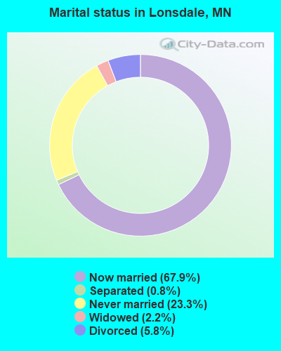
- Never married: 23.3%
- Now married: 67.9%
- Separated: 0.8%
- Widowed: 2.2%
- Divorced: 5.8%
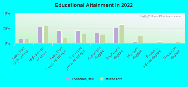
For population 25 years and over in Lonsdale:
- High school or higher: 93.4%
- Bachelor's degree or higher: 21.6%
- Graduate or professional degree: 3.2%
- Unemployed: 3.9%
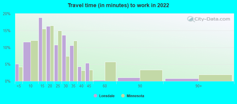
- Mean travel time to work (commute): 26.3 minutes
| Here: | 8.8 |
| Minnesota average: | 10.9 |

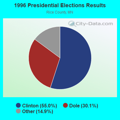
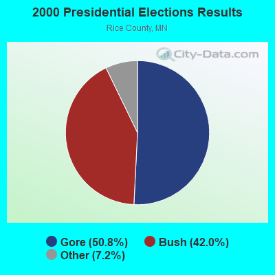
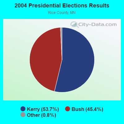
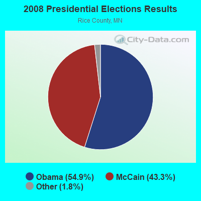
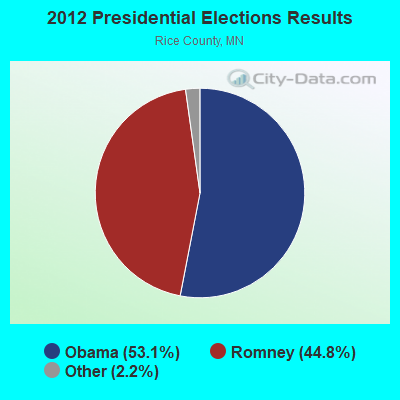
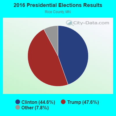
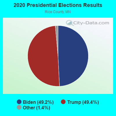
Graphs represent county-level data. Detailed 2008 Election Results
Religion statistics for Lonsdale, MN (based on Rice County data)
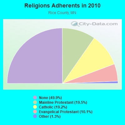
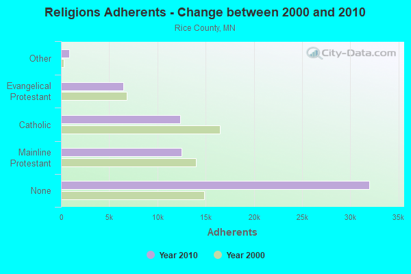
| Religion | Adherents | Congregations |
|---|---|---|
| Mainline Protestant | 12,510 | 24 |
| Catholic | 12,337 | 6 |
| Evangelical Protestant | 6,461 | 31 |
| Other | 840 | 8 |
| None | 31,994 | - |
Food Environment Statistics:
| Here: | 1.13 / 10,000 pop. |
| Minnesota: | 1.83 / 10,000 pop. |
| Rice County: | 0.16 / 10,000 pop. |
| State: | 0.49 / 10,000 pop. |
| Here: | 4.05 / 10,000 pop. |
| Minnesota: | 3.90 / 10,000 pop. |
| Here: | 4.86 / 10,000 pop. |
| Minnesota: | 6.98 / 10,000 pop. |
| This county: | 6.2% |
| Minnesota: | 6.5% |
| Rice County: | 25.8% |
| Minnesota: | 25.9% |
| This county: | 15.1% |
| Minnesota: | 13.0% |
Health and Nutrition:
| Lonsdale: | 52.0% |
| Minnesota: | 50.6% |
| Lonsdale: | 51.7% |
| Minnesota: | 48.4% |
| Lonsdale: | 28.3 |
| Minnesota: | 28.5 |
| Lonsdale: | 22.1% |
| State: | 21.0% |
| Here: | 8.2% |
| State: | 9.8% |
| Lonsdale: | 6.9 |
| State: | 6.8 |
| This city: | 31.8% |
| Minnesota: | 33.5% |
| This city: | 59.6% |
| State: | 57.7% |
| Lonsdale: | 80.1% |
| Minnesota: | 79.3% |
More about Health and Nutrition of Lonsdale, MN Residents
| Local government employment and payroll (March 2022) | |||||
| Function | Full-time employees | Monthly full-time payroll | Average yearly full-time wage | Part-time employees | Monthly part-time payroll |
|---|---|---|---|---|---|
| Police Protection - Officers | 5 | $35,063 | $84,151 | 1 | $689 |
| Streets and Highways | 3 | $16,036 | $64,144 | 0 | $0 |
| Other Government Administration | 2 | $18,427 | $110,562 | 0 | $0 |
| Other and Unallocable | 2 | $9,395 | $56,370 | 5 | $4,030 |
| Parks and Recreation | 2 | $10,294 | $61,764 | 0 | $0 |
| Local Libraries | 1 | $4,451 | $53,412 | 4 | $3,288 |
| Police - Other | 1 | $4,592 | $55,104 | 0 | $0 |
| Water Supply | 1 | $5,314 | $63,768 | 0 | $0 |
| Sewerage | 1 | $6,756 | $81,072 | 0 | $0 |
| Financial Administration | 1 | $6,636 | $79,632 | 1 | $1,457 |
| Totals for Government | 19 | $116,965 | $73,873 | 11 | $9,465 |
Lonsdale government finances - Expenditure in 2021 (per resident):
- Construction - Regular Highways: $1,780,000 ($362.53)
- Current Operations - Liquor Stores: $1,948,000 ($396.74)
Police Protection: $830,000 ($169.04)
Sewerage: $776,000 ($158.04)
Water Utilities: $735,000 ($149.69)
General - Other: $583,000 ($118.74)
Regular Highways: $381,000 ($77.60)
Financial Administration: $295,000 ($60.08)
Parks and Recreation: $223,000 ($45.42)
Local Fire Protection: $221,000 ($45.01)
Libraries: $129,000 ($26.27)
Central Staff Services: $17,000 ($3.46)
- General - Interest on Debt: $388,000 ($79.02)
- Other Capital Outlay - Parks and Recreation: $893,000 ($181.87)
Police Protection: $444,000 ($90.43)
Regular Highways: $266,000 ($54.18)
Local Fire Protection: $201,000 ($40.94)
General - Other: $43,000 ($8.76)
Sewerage: $17,000 ($3.46)
Water Utilities: $10,000 ($2.04)
Libraries: $9,000 ($1.83)
- Water Utilities - Interest on Debt: $57,000 ($11.61)
Lonsdale government finances - Revenue in 2021 (per resident):
- Charges - Sewerage: $1,245,000 ($253.56)
Other: $178,000 ($36.25)
Regular Highways: $7,000 ($1.43)
Parks and Recreation: $1,000 ($0.20)
- Federal Intergovernmental - Health and Hospitals: $309,000 ($62.93)
Other: $280,000 ($57.03)
- Local Intergovernmental - Other: $143,000 ($29.12)
- Miscellaneous - Special Assessments: $632,000 ($128.72)
General Revenue - Other: $124,000 ($25.25)
Fines and Forfeits: $24,000 ($4.89)
Interest Earnings: $20,000 ($4.07)
- Revenue - Liquor Stores: $2,275,000 ($463.34)
Water Utilities: $613,000 ($124.85)
- State Intergovernmental - General Local Government Support: $487,000 ($99.19)
Other: $121,000 ($24.64)
- Tax - Property: $2,090,000 ($425.66)
Other License: $224,000 ($45.62)
Public Utilities Sales: $55,000 ($11.20)
Lonsdale government finances - Debt in 2021 (per resident):
- Long Term Debt - Beginning Outstanding - Unspecified Public Purpose: $13,361,000 ($2721.18)
Outstanding Unspecified Public Purpose: $12,435,000 ($2532.59)
Retired Unspecified Public Purpose: $2,976,000 ($606.11)
Issue, Unspecified Public Purpose: $2,050,000 ($417.52)
Lonsdale government finances - Cash and Securities in 2021 (per resident):
- Other Funds - Cash and Securities: $4,333,000 ($882.48)
Businesses in Lonsdale, MN
- Subway: 1
- U-Haul: 1
Strongest AM radio stations in Lonsdale:
- KFAN (1130 AM; 50 kW; MINNEAPOLIS, MN; Owner: AMFM RADIO LICENSES, L.L.C.)
- WCTS (1030 AM; 50 kW; MAPLEWOOD, MN; Owner: CNTL. BAPT. THEO/AL SEMI MINNEAPOLIS)
- WCCO (830 AM; 50 kW; MINNEAPOLIS, MN; Owner: INFINITY MEDIA CORPORATION)
- KSTP (1500 AM; 50 kW; ST. PAUL, MN; Owner: KSTP-AM, LLC (DELAWARE))
- KDHL (920 AM; 5 kW; FARIBAULT, MN; Owner: CUMULUS LICENSING CORP.)
- WMNN (1330 AM; 10 kW; MINNEAPOLIS, MN; Owner: MINNESOTA PUBLIC RADIO.)
- KTIS (900 AM; 25 kW; MINNEAPOLIS, MN; Owner: NORTHWESTERN COLLEGE)
- KSMM (1530 AM; 9 kW; SHAKOPEE, MN; Owner: STARBOARD BROADCASTING, INC.)
- KKMS (980 AM; 5 kW; RICHFIELD, MN)
- KCHK (1350 AM; 0 kW; NEW PRAGUE, MN; Owner: RADIO SOUTHERN MINNESOTA, LLC)
- WDGY (630 AM; 8 kW; HUDSON, WI; Owner: 630 RADIO, INCORPORATED)
- KUOM (770 AM; daytime; 5 kW; MINNEAPOLIS, MN)
- KYMN (1080 AM; 1 kW; NORTHFIELD, MN)
Strongest FM radio stations in Lonsdale:
- KRDS-FM (95.5 FM; NEW PRAGUE, MN; Owner: RADIO SOUTHERN MINNESOTA, LLC)
- KQCL (95.9 FM; FARIBAULT, MN; Owner: CUMULUS LICENSING CORP.)
- WCAL (89.3 FM; NORTHFIELD, MN; Owner: ST. OLAF COLLEGE)
- WGVX (105.1 FM; LAKEVILLE, MN; Owner: KQRS, INC.)
- KNOW-FM (91.1 FM; MINNEAPOLIS-ST. PAUL, MN; Owner: MINNESOTA PUBLIC RADIO)
- WLTE (102.9 FM; MINNEAPOLIS, MN; Owner: INFINITY MEDIA CORPORATION)
- KTCZ-FM (97.1 FM; MINNEAPOLIS, MN; Owner: AMFM RADIO LICENSES, L.L.C.)
- KSTP-FM (94.5 FM; ST. PAUL, MN; Owner: KSTP-FM, LLC, A DELAWARE LLC)
- KBGY (107.5 FM; FARIBAULT, MN; Owner: MILESTONE RADIO II LLC)
- KEEY-FM (102.1 FM; ST. PAUL, MN; Owner: AMFM RADIO LICENSES, L.L.C.)
- KTIS-FM (98.5 FM; MINNEAPOLIS, MN; Owner: NORTHWESTERN COLLEGE)
- KDWB-FM (101.3 FM; RICHFIELD, MN; Owner: AMFM RADIO LICENSES, L.L.C.)
- KQRS-FM (92.5 FM; GOLDEN VALLEY, MN; Owner: KQRS, Inc.)
- KSJN (99.5 FM; MINNEAPOLIS, MN; Owner: MINNESOTA PUBLIC RADIO)
- KXXR (93.7 FM; MINNEAPOLIS, MN; Owner: KQRS, INC.)
- KOWZ-FM (100.9 FM; BLOOMING PRAIRIE, MN; Owner: BLOOMING PRAIRIE FARM RADIO INC.)
- KRUE (92.1 FM; WASECA, MN; Owner: MAIN STREET BROADCASTING, INC.)
TV broadcast stations around Lonsdale:
- KMSP-TV (Channel 9; MINNEAPOLIS, MN; Owner: FOX TELEVISION STATIONS, INC.)
- KARE (Channel 11; MINNEAPOLIS, MN; Owner: MULTIMEDIA HOLDINGS CORPORATION)
- KSTP-TV (Channel 5; ST. PAUL, MN; Owner: HUBBARD BROADCASTING, INC.)
- KTCA-TV (Channel 2; ST. PAUL, MN; Owner: TWIN CITIES PUBLIC TELEVISION, INC.)
- WCCO-TV (Channel 4; MINNEAPOLIS, MN; Owner: CBS BROADCASTING INC.)
- K07UI (Channel 7; MINNEAPOLIS, ETC., MN; Owner: WORD OF GOD FELLOWSHIP, INC.)
- KTCI-TV (Channel 17; ST. PAUL, MN; Owner: TWIN CITIES PUBLIC TELEVISION, INC.)
- KSTC-TV (Channel 45; MINNEAPOLIS, MN; Owner: HUBBARD BROADCASTING, INC.)
- KMWB (Channel 23; MINNEAPOLIS, MN; Owner: KLGT LICENSEE, LLC)
- WFTC (Channel 29; MINNEAPOLIS, MN; Owner: FOX TELEVISION STATIONS, INC.)
- K58BS (Channel 58; MINNEAPOLIS, MN; Owner: TRINITY BROADCASTING NETWORK)
- K67HG (Channel 67; MINNEAPOLIS, MN; Owner: VENTANA TELEVISION, INC.)
- K14KH (Channel 14; MINNEAPOLIS, MN; Owner: THREE ANGELS BROADCASTING NETWORK)
- K19ER (Channel 19; ST. PAUL, MN; Owner: CATHOLIC VIEWS BROADCASTS, INC.)
- W62BD (Channel 62; MINNEAPOLIS, MN; Owner: WORD OF GOD FELLOWSHIP, INC.)
- WBWX-CA (Channel 13; MINNEAPOLIS, MN; Owner: THE BOX WORLDWIDE LLC)
Lonsdale fatal accident list:
Jul 1, 2000 02:38 AM, Sr-19, Lat: 44.480518, Lon: -93.431082, Vehicles: 2, Persons: 2, Fatalities: 1, Drunk persons involved: 1
- National Bridge Inventory (NBI) Statistics
- 1Number of bridges
- 7ft / 1.6mTotal length
- 96Total average daily traffic
- 96Total future (year 2029) average daily traffic
FCC Registered Cell Phone Towers:
1- 150 Delaware Street (81736) (Lat: 44.477194 Lon: -93.423056), Type: Ltower, Structure height: 54.2 m, Overall height: 58.2 m, Call Sign: KNKN572
Assigned Frequencies: 869.040 MHz, 869.040 MHz, 869.040 MHz, 824.040 MHz, 824.040 MHz, 824.040 MHz, 890.010 MHz, 890.010 MHz, 890.010 MHz, 845.010 MHz, 845.010 MHz, 845.010 MHzGrant Date: 09/08/2021, Expiration Date: 10/01/2031, Certifier: Michael P GogginRegistrant: At&t Services, Inc., 208 S Akard St, 20f, Dallas, TX 75202, Phone: (855) 699-7073, Email:
FCC Registered Antenna Towers:
5- Stormy M Seibt, 4.0 Km Nne (Lat: 44.529167 Lon: -93.408056), Type: 96.0, Overall height: 85.6 m, Registrant: American Tower Limited Partnership, Schau-mburg, Phone: (847) 240-1508
- Shelley Doolity, 4.0 Km Nne (Lat: 44.529167 Lon: -93.408056), Type: 96.0, Overall height: 85.6 m, Registrant: State Of Minnesota, Dept Of Transportation, Saint- Paul, Phone: (651) 296-7421
- Robert J Prudhomme, 4.0 Km Nne (Lat: 44.529167 Lon: -93.408056), Type: 96.0, Overall height: 85.6 m, Registrant: State Of Minnesota, Dept Of Transportation, James.Mohn@state.Mn.Us, , Saint- Paul, Phone: (651) 234-7969
- Guy Chambers, 4.0 Km Nne (Lat: 44.529167 Lon: -93.408056), Type: 96.0, Structure height: 27131 m, Overall height: 85.6 m, Registrant: State Of Minnesota, Radio.Engineering.Dot@state.Mn.Us, , Saint- Paul, Phone: (651) 234-7961
- 4.0 Km Nne (Lat: 44.529167 Lon: -93.408056), Type: 96.0, Overall height: 85.6 m, Registrant: At&t Corp, Pcheeks@att.Com, , Atlan-ta, Phone: (404) 810-4021
FCC Registered Broadcast Land Mobile Towers:
6- 2 Miles N Of Lake Mazaska Sec 18 (Lat: 44.415250 Lon: -93.393833), Call Sign: KWL790, Licensee ID: L00043050,
Assigned Frequencies: 153.005 MHz, Grant Date: 10/23/2014, Expiration Date: 11/20/2024, Registrant: Allen L Ross, 11840 Falls Trail, Lonsdale, MN 55046, Phone: (507) 744-2589
- 4.0 Km Nne (Lat: 44.529167 Lon: -93.408056), Type: Tower, Structure height: 85.6 m, Overall height: 96 m, Call Sign: WPXI391, Licensee ID: L00001503,
Assigned Frequencies: 854.362 MHz, Grant Date: 04/10/2003, Expiration Date: 10/10/2003, Cancellation Date: 12/14/2003, Certifier: David C Savolainen, Registrant: State Of Minnesota, 395 John Ireland Blvd. Ms730, St. Paul, MN 55155, Phone: (651) 297-8266, Fax: (651) 297-5735, Email:
- LONSDALE, 4.0 Km Nne (Lat: 44.529167 Lon: -93.408056), Type: Tower, Structure height: 85.6 m, Overall height: 96 m, Call Sign: WQAI413,
Assigned Frequencies: 154.935 MHz, 154.935 MHz, Grant Date: 06/07/2004, Expiration Date: 06/07/2014, Cancellation Date: 12/18/2012, Certifier: Thomas E Walsh, Registrant: State Of Minnesota, 395 John Ireland Blvd Ms730, Saint Paul, MN 55155, Phone: (651) 296-7418, Fax: (651) 297-5735, Email:
- Lat: 44.480778 Lon: -93.426889, Call Sign: WQAM438,
Assigned Frequencies: 151.790 MHz, Grant Date: 06/18/2014, Expiration Date: 07/01/2024, Certifier: Vicki Marvin, Registrant: Advanced Wireless Communications Inc, 20809 Kensington Blvd, Lakeville, MN 55044-7486, Phone: (952) 469-5400, Fax: (952) 469-0170
- 1000 Birch St (Lat: 44.481667 Lon: -93.413611), Call Sign: WQDL649,
Assigned Frequencies: 462.212 MHz, 462.262 MHz, 462.362 MHz, 462.412 MHz, 462.437 MHz, Grant Date: 09/01/2015, Expiration Date: 09/26/2025, Certifier: David Gunderson, Registrant: Advanced Wireless Communications, 20809 Kensington Blvd, Lakeville, MN 55044-8353, Phone: (952) 469-5400, Email:
- LONSDALE, 4.0 Km Nne (Lat: 44.529167 Lon: -93.408056), Type: Ltower, Structure height: 85.6 m, Overall height: 96 m, Call Sign: WQDX262,
Assigned Frequencies: 154.160 MHz, Grant Date: 09/02/2015, Expiration Date: 11/21/2025, Certifier: Richard Cook, Registrant: Rice County Sheriff\'s Office, 118 Nw 3rd Street, Faribault, MN 55021, Phone: (507) 332-6120, Fax: (507) 332-6297, Email:
FCC Registered Microwave Towers:
8 (See the full list of FCC Registered Microwave Towers in this town)FCC Registered Amateur Radio Licenses:
13 (See the full list of FCC Registered Amateur Radio Licenses in Lonsdale)FAA Registered Aircraft:
7- Aircraft: BURKHART GROB G 103 TWIN II (Category: Land, Seats: 2, Weight: Up to 12,499 Pounds), Engine: None
N-Number: 103XS, N103XS, N-103XS, Serial Number: 3745, Year manufactured: 1982, Airworthiness Date: 12/27/2005, Certificate Issue Date: 11/15/2005
Registrant (Corporation): Cross Country Soaring Inc, 4231 120th St W, Lonsdale, MN 55046 - Aircraft: S.O.C.A.T.A. RALLYE 235E (Category: Land, Seats: 4, Weight: Up to 12,499 Pounds), Engine: LYCOMING 0-540 SERIES (250 HP) (Reciprocating)
N-Number: 312RA, N312RA, N-312RA, Serial Number: 12937, Year manufactured: 1977, Airworthiness Date: 01/17/1978, Certificate Issue Date: 07/26/2004
Registrant (Corporation): Cross Country Soaring Inc, 4231 120th St W, Lonsdale, MN 55046 - Aircraft: BURKHART GROB FLUGZEUGBAU G103 TWIN ASTIR (Category: Land, Seats: 2, Weight: Up to 12,499 Pounds), Engine: None
N-Number: 3837M, N3837M, N-3837M, Serial Number: 3764, Year manufactured: 1983, Airworthiness Date: 04/12/1983, Certificate Issue Date: 06/07/2004
Registrant (Corporation): Cross Country Soaring Inc, 4321 120th St W, Lonsdale, MN 55046 - Aircraft: FLIGHT DESIGN GMBH CTLS (Category: Land, Seats: 2, Weight: Up to 12,499 Pounds), Engine: ROTAX 912ULS SERIES (100 HP) (4 Cycle)
N-Number: 452WG, N452WG, N-452WG, Serial Number: F-10-08-06, Year manufactured: 2010, Airworthiness Date: 12/07/2010, Certificate Issue Date: 09/05/2019
Registrant (Individual): Martin C Curtis, Po Box 257, Lonsdale, MN 55046 - Aircraft: CESSNA 140A (Category: Land, Seats: 2, Weight: Up to 12,499 Pounds, Speed: 105 mph), Engine: CONT MOTOR C90 SERIES (95 HP) (Reciprocating)
N-Number: 5334C, N5334C, N-5334C, Serial Number: 15563, Year manufactured: 1950, Airworthiness Date: 09/18/1955, Certificate Issue Date: 09/08/2020
Registrant (Co-Owned): Kenneth C Snyder, 7251 130th St W, Lonsdale, MN 55046, Other Owners: Amy L Nystrom - Aircraft: AMERICAN CHAMPION AIRCRAFT 7GCAA (Category: Land, Seats: 2, Weight: Up to 12,499 Pounds), Engine: LYCOMING O-320-B2B (160 HP) (Reciprocating)
N-Number: 757US, N757US, N-757US, Serial Number: 526-2019, Year manufactured: 2019, Airworthiness Date: 04/15/2019, Certificate Issue Date: 05/21/2019
Registrant (Individual): Robert E Peasley, 5200 Clearwater Trl, Lonsdale, MN 55046 - Aircraft: AMERICAN CHAMPION AIRCRAFT 8KCAB (Category: Land, Weight: Up to 12,499 Pounds), Engine: LYCOMING AEIO-360 SER (180 HP) (Reciprocating)
N-Number: 757US, N757US, N-757US, Serial Number: 958-2004, Year manufactured: 2004, Airworthiness Date: 05/28/2004, Certificate Issue Date: 08/02/2005
Registrant (Individual): Robert E Peasley, 5200 Clearwater Trl, Lonsdale, MN 55046
Deregistered: Cancel Date: 11/29/2018
2002 - 2018 National Fire Incident Reporting System (NFIRS) incidents
- Fire incident types reported to NFIRS in Lonsdale, MN
- 5441.9%Outside Fires
- 4333.3%Structure Fires
- 2720.9%Mobile Property/Vehicle Fires
- 53.9%Other
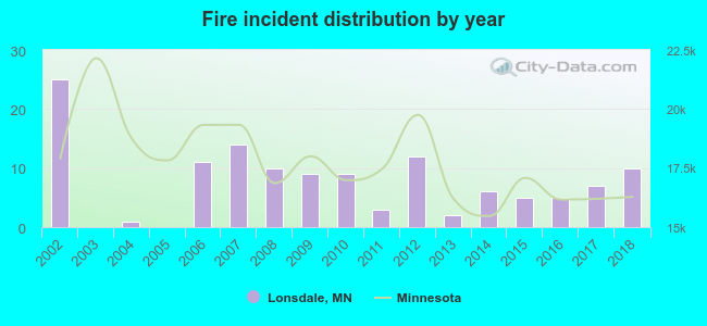 According to the data from the years 2002 - 2018 the average number of fire incidents per year is 8. The highest number of fires - 25 took place in 2002, and the least - 0 in 2003. The data has a declining trend.
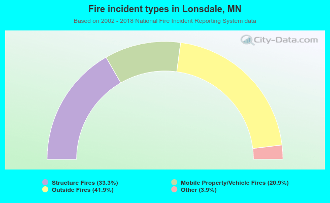 When looking into fire subcategories, the most reports belonged to: Outside Fires (41.9%), and Structure Fires (33.3%).
| Most common first names in Lonsdale, MN among deceased individuals | ||
| Name | Count | Lived (average) |
|---|---|---|
| Joseph | 36 | 80.9 years |
| Frank | 35 | 80.3 years |
| Mary | 31 | 86.2 years |
| William | 16 | 77.9 years |
| John | 15 | 82.3 years |
| James | 13 | 77.8 years |
| George | 12 | 76.1 years |
| Anna | 11 | 85.7 years |
| Thomas | 11 | 81.4 years |
| Helen | 10 | 81.1 years |
| Most common last names in Lonsdale, MN among deceased individuals | ||
| Last name | Count | Lived (average) |
|---|---|---|
| Malecha | 23 | 75.6 years |
| Skluzacek | 15 | 79.6 years |
| Trnka | 15 | 77.3 years |
| Tuma | 12 | 81.6 years |
| Smisek | 12 | 81.0 years |
| Sticha | 11 | 80.9 years |
| Pumper | 10 | 73.3 years |
| Novak | 10 | 82.5 years |
| Jirik | 10 | 79.1 years |
| Sirek | 9 | 79.2 years |
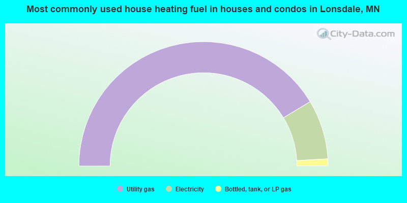
- 82.7%Utility gas
- 15.5%Electricity
- 1.8%Bottled, tank, or LP gas
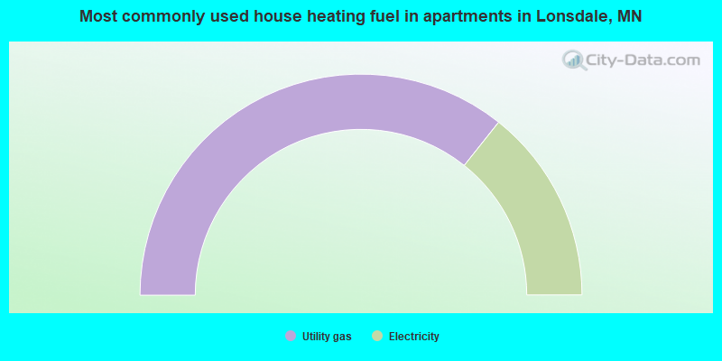
- 71.4%Utility gas
- 28.6%Electricity
Lonsdale compared to Minnesota state average:
- Unemployed percentage significantly below state average.
- Black race population percentage significantly below state average.
- Hispanic race population percentage above state average.
- Median age significantly below state average.
- Foreign-born population percentage below state average.
- Renting percentage significantly below state average.
- Length of stay since moving in significantly below state average.
- House age significantly below state average.
- Number of college students above state average.

|
|
Total of 82 patent applications in 2008-2024.