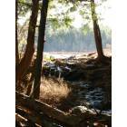
Westminster, Massachusetts
Submit your own pictures of this town and show them to the world
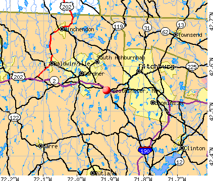
- OSM Map
- General Map
- Google Map
- MSN Map
Population change since 2000: +5.4%
 |
| Males: 3,640 | |
| Females: 3,637 |
| Median resident age: | 42.8 years |
| Massachusetts median age: | 39.2 years |
Zip codes: 01473.
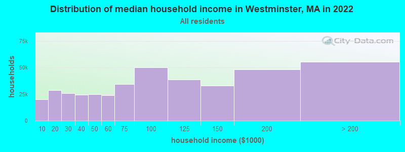
| Westminster: | $104,061 |
| MA: | $94,488 |
Estimated per capita income in 2022: $48,575 (it was $24,913 in 2000)
Westminster town income, earnings, and wages data
Estimated median house or condo value in 2022: $394,905 (it was $143,000 in 2000)
| Westminster: | $394,905 |
| MA: | $534,700 |
Mean prices in 2022: all housing units: $419,164; detached houses: $447,621; townhouses or other attached units: $343,592; in 2-unit structures: $323,295; in 3-to-4-unit structures: $332,295; in 5-or-more-unit structures: $232,758; mobile homes: $113,885
Detailed information about poverty and poor residents in Westminster, MA


Compare current foreclosures near Westminster, MA:
| Photo | Address | Area | Beds / Baths | Price | Details |
|---|---|---|---|---|---|

|
#1
Gatehouse Rd
Westminster, MA 01473
|
1,118 sq. feet
|
1 baths 2 beds |
show details | |

|
#2
Rebanna Rd
Westminster, MA 01473
|
3,313 sq. feet
|
2 baths 4 beds |
show details | |

|
#3
Woodland Dr
Westminster, MA 01473
|
3,273 sq. feet
|
2 baths 4 beds |
show details | |

|
#4
W Hill Dr
Westminster, MA 01473
|
1,200 sq. feet
|
2 baths 3 beds |
show details | |

|
#5
Carter Rd
Westminster, MA 01473
|
2,182 sq. feet
|
1 baths 3 beds |
show details | |

|
#6
Crestview Ln
Westminster, MA 01473
|
1,100 sq. feet
|
1 baths 2 beds |
show details | |

|
#7
Village Inn Rd
Westminster, MA 01473
|
- sq. feet
|
- baths - beds |
show details | |

|
#8
Iriquois Dr
Ashburnham, MA 01430
|
2,016 sq. feet
|
2 baths 3 beds |
$369,000
|
show details |

|
#9
Sylvan Ave
Leominster, MA 01453
|
720 sq. feet
|
1 baths 2 beds |
$375,000
|
show details |

|
#10
Great Rd
Shirley, MA 01464
|
1,672 sq. feet
|
1 baths 2 beds |
$464,900
|
show details |
| Photo | Address | Area | Beds / Baths | Price | Details |
|---|---|---|---|---|---|

|
#11
N Brookfield Rd
Oakham, MA 01068
|
1,078 sq. feet
|
1 baths 2 beds |
$459,900
|
show details |

|
#12
Pearl Hill Rd
Fitchburg, MA 01420
|
2,152 sq. feet
|
2 baths 3 beds |
$529,900
|
show details |

|
#13
Parker St
Gardner, MA 01440
|
1,980 sq. feet
|
2 baths 4 beds |
$469,900
|
show details |

|
#14
Graham St
Leominster, MA 01453
|
1,036 sq. feet
|
1 baths 3 beds |
$485,000
|
show details |

|
#15
Overlook Rd
Westminster, MA 01473
|
- sq. feet
|
- baths - beds |
show details | |

|
#16
Garnet St
Fitchburg, MA 01420
|
6,112 sq. feet
|
5 baths 8 beds |
show details | |

|
#17
Reagan Rd
Townsend, MA 01469
|
1,591 sq. feet
|
2 baths 3 beds |
show details | |

|
#18
Lakeshore Dr
Ashburnham, MA 01430
|
- sq. feet
|
- baths - beds |
$5,000
|
show details |

|
#19
Clyde St
Fitchburg, MA 01420
|
2,028 sq. feet
|
3 baths 5 beds |
show details | |

|
#20
Grove Ave
Leominster, MA 01453
|
3,097 sq. feet
|
1 baths 4 beds |
show details |
| Photo | Address | Area | Beds / Baths | Price | Details |
|---|---|---|---|---|---|

|
#21
Mill St
Greenville, NH 03048
|
1,201 sq. feet
|
1 baths 2 beds |
show details | |

|
#22
Rindge State Rd
Ashburnham, MA 01430
|
1,260 sq. feet
|
1 baths 3 beds |
show details | |

|
#23
Mallard Drive, Unit 59 Coggshall Crossing Condominium
Fitchburg, MA 01420
|
1,306 sq. feet
|
1 baths 2 beds |
show details | |

|
#24
Lorchris St
Leominster, MA 01453
|
1,032 sq. feet
|
1 baths 2 beds |
show details | |

|
#25
Nanigian Rd
Paxton, MA 01612
|
1,096 sq. feet
|
1 baths 2 beds |
show details | |

|
#26
Colonial Dr
Rutland, MA 01543
|
1,772 sq. feet
|
2 baths 3 beds |
show details | |

|
#27
Main St
Lancaster, MA 01523
|
1,960 sq. feet
|
2 baths 3 beds |
show details | |

|
#28
Page St
Lunenburg, MA 01462
|
1,764 sq. feet
|
2 baths 3 beds |
show details | |

|
#29
Lunenburg Rd
Lancaster, MA 01523
|
2,028 sq. feet
|
2 baths 3 beds |
show details | |

|
#30
Holbrook Ln
Paxton, MA 01612
|
1,600 sq. feet
|
2 baths 3 beds |
show details |
| Photo | Address | Area | Beds / Baths | Price | Details |
|---|---|---|---|---|---|

|
#31
Springhill Rd
Barre, MA 01005
|
1,075 sq. feet
|
1 baths 2 beds |
show details | |

|
#32
Winifreds Way
Rutland, MA 01543
|
1,736 sq. feet
|
2 baths 3 beds |
show details | |

|
#33
Old Petersham Rd
Barre, MA 01005
|
2,816 sq. feet
|
3 baths 4 beds |
show details | |

|
#34
Britney Dr
Rutland, MA 01543
|
1,672 sq. feet
|
1 baths 3 beds |
show details | |

|
#35
Queen Lake Rd
Athol, MA 01331
|
3,416 sq. feet
|
2 baths 4 beds |
show details | |

|
#36
Hemlock Dr
Lunenburg, MA 01462
|
696 sq. feet
|
1 baths 2 beds |
show details | |

|
#37
Maple St
Winchendon, MA 01475
|
1,000 sq. feet
|
1 baths 2 beds |
show details | |

|
#38
Derby Rd
Berlin, MA 01503
|
1,296 sq. feet
|
1 baths 2 beds |
show details | |

|
#39
Jackson Ave
Rutland, MA 01543
|
2,344 sq. feet
|
2 baths 4 beds |
show details | |

|
#40
Maple St
Winchendon, MA 01475
|
903 sq. feet
|
1 baths 2 beds |
show details |
| Photo | Address | Area | Beds / Baths | Price | Details |
|---|---|---|---|---|---|

|
#41
Emery Rd
Townsend, MA 01469
|
2,224 sq. feet
|
2 baths 3 beds |
show details | |

|
#42
Oakridge Dr
Rutland, MA 01543
|
1,190 sq. feet
|
1 baths 3 beds |
show details | |

|
#43
Juniper St
Winchendon, MA 01475
|
1,687 sq. feet
|
1 baths 4 beds |
show details | |

|
#44
Spruce St
Winchendon, MA 01475
|
1,504 sq. feet
|
1 baths 3 beds |
show details | |

|
#45
Hill St
Winchendon, MA 01475
|
1,549 sq. feet
|
1 baths 3 beds |
show details | |

|
#46
Muddy Pond Rd
Sterling, MA 01564
|
1,056 sq. feet
|
1 baths 3 beds |
show details | |

|
#47
Chestnut St
Athol, MA 01331
|
1,503 sq. feet
|
2 baths 4 beds |
show details | |

|
#48
East St
Petersham, MA 01366
|
2,732 sq. feet
|
2 baths 6 beds |
show details | |

|
#49
Prospect St
Leominster, MA 01453
|
4,884 sq. feet
|
2 baths 4 beds |
show details | |

|
Check over 1 million property listings on Foreclosure.com!
|
browse all offers | |||

- 6,86894.4%White alone
- 1932.7%Hispanic
- 731.0%Asian alone
- 620.9%Black alone
- 630.9%Two or more races
- 110.2%American Indian alone
- 70.10%Other race alone
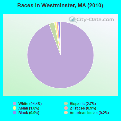
Races in Westminster detailed stats: ancestries, foreign born residents, place of birth
According to our research of Massachusetts and other state lists, there were 3 registered sex offenders living in Westminster, Massachusetts as of May 05, 2024.
The ratio of all residents to sex offenders in Westminster is 2,426 to 1.
The ratio of registered sex offenders to all residents in this city is lower than the state average.
Type |
2009 |
2010 |
2011 |
2012 |
2013 |
2014 |
2015 |
2016 |
2017 |
2018 |
2019 |
2020 |
2021 |
2022 |
|---|---|---|---|---|---|---|---|---|---|---|---|---|---|---|
| Murders (per 100,000) | 0 (0.0) | 0 (0.0) | 0 (0.0) | 0 (0.0) | 0 (0.0) | 0 (0.0) | 0 (0.0) | 0 (0.0) | 0 (0.0) | 0 (0.0) | 0 (0.0) | 0 (0.0) | 0 (0.0) | 0 (0.0) |
| Rapes (per 100,000) | 3 (40.0) | 0 (0.0) | 0 (0.0) | 0 (0.0) | 0 (0.0) | 0 (0.0) | 2 (26.6) | 0 (0.0) | 1 (13.0) | 3 (38.3) | 1 (12.7) | 1 (12.4) | 3 (36.4) | 7 (83.7) |
| Robberies (per 100,000) | 0 (0.0) | 1 (13.7) | 1 (13.7) | 2 (27.1) | 0 (0.0) | 1 (13.4) | 0 (0.0) | 0 (0.0) | 1 (13.0) | 0 (0.0) | 0 (0.0) | 0 (0.0) | 0 (0.0) | 0 (0.0) |
| Assaults (per 100,000) | 16 (213.3) | 7 (96.2) | 6 (82.0) | 8 (108.6) | 9 (122.0) | 9 (120.7) | 21 (279.6) | 19 (250.2) | 18 (233.8) | 10 (127.6) | 19 (240.4) | 13 (161.7) | 6 (72.8) | 12 (143.5) |
| Burglaries (per 100,000) | 13 (173.3) | 35 (481.0) | 18 (245.9) | 16 (217.2) | 17 (230.4) | 11 (147.6) | 16 (213.0) | 11 (144.8) | 7 (90.9) | 4 (51.1) | 5 (63.3) | 4 (49.8) | 4 (48.5) | 5 (59.8) |
| Thefts (per 100,000) | 98 (1,306) | 62 (852.0) | 236 (3,224) | 124 (1,683) | 169 (2,291) | 95 (1,274) | 79 (1,052) | 55 (724.2) | 57 (740.4) | 44 (561.6) | 36 (455.6) | 36 (447.9) | 40 (485.2) | 36 (430.5) |
| Auto thefts (per 100,000) | 5 (66.6) | 4 (55.0) | 4 (54.6) | 0 (0.0) | 3 (40.7) | 2 (26.8) | 6 (79.9) | 5 (65.8) | 0 (0.0) | 1 (12.8) | 2 (25.3) | 3 (37.3) | 4 (48.5) | 4 (47.8) |
| Arson (per 100,000) | 2 (26.7) | 0 (0.0) | 0 (0.0) | 0 (0.0) | 0 (0.0) | 1 (13.4) | 0 (0.0) | 1 (13.2) | 0 (0.0) | 1 (12.8) | 0 (0.0) | 2 (24.9) | 0 (0.0) | 2 (23.9) |
| City-Data.com crime index | 144.4 | 95.5 | 171.0 | 112.4 | 135.4 | 91.6 | 140.6 | 94.4 | 97.0 | 83.2 | 82.9 | 66.7 | 70.4 | 120.9 |
The City-Data.com crime index weighs serious crimes and violent crimes more heavily. Higher means more crime, U.S. average is 246.1. It adjusts for the number of visitors and daily workers commuting into cities.
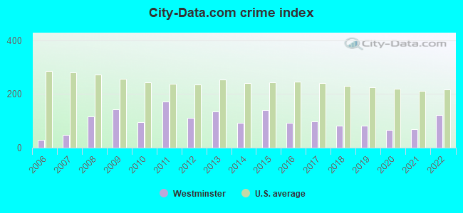
Crime rate in Westminster detailed stats: murders, rapes, robberies, assaults, burglaries, thefts, arson
Full-time law enforcement employees in 2021, including police officers: 19 (15 officers - 13 male; 2 female).
| Officers per 1,000 residents here: | 1.82 |
| Massachusetts average: | 2.53 |
 Recent articles from our blog. Our writers, many of them Ph.D. graduates or candidates, create easy-to-read articles on a wide variety of topics.


 | 2023 Real Estate Observations (5278 replies) |
| Boston Racial Stigma- is it "cool" to hate on Boston? (632 replies) |
| People leaving MA (103 replies) |
| Affordable places to live for a boring hermit? (88 replies) |
| Towns within 495 with nice walkable downtowns and good schools (205 replies) |
| Police expecting a rough summer ahead, in the city. (2484 replies) |
Latest news from Westminster, MA collected exclusively by city-data.com from local newspapers, TV, and radio stations
Ancestries: Irish (19.1%), French (18.7%), English (13.8%), French Canadian (12.4%), Italian (9.8%), German (4.9%).
Current Local Time: EST time zone
Incorporated in 1770
Elevation: 1080 feet
Land area: 35.5 square miles.
Population density: 205 people per square mile (very low).
229 residents are foreign born (2.0% Europe, 0.8% Asia, 0.4% North America).
| This town: | 3.3% |
| Massachusetts: | 12.2% |
| Westminster town: | 1.3% ($1,904) |
| Massachusetts: | 1.3% ($2,336) |
Nearest city with pop. 50,000+: Worcester, MA  (19.7 miles , pop. 172,648).
Nearest city with pop. 200,000+: Boston, MA (44.3 miles , pop. 589,141).
Nearest city with pop. 1,000,000+: Bronx, NY (155.4 miles , pop. 1,332,650).
Nearest cities:
), Latitude: 42.54 N, Longitude: 71.90 W
Area code: 978

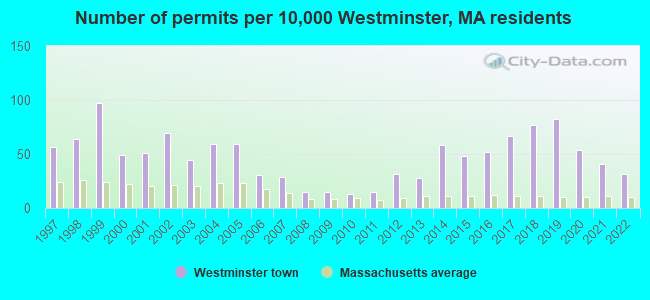
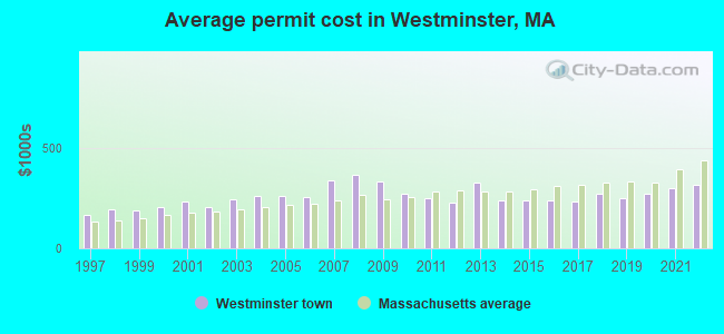
Single-family new house construction building permits:
- 2022: 22 buildings, average cost: $313,000
- 2021: 28 buildings, average cost: $301,300
- 2020: 37 buildings, average cost: $273,400
- 2019: 57 buildings, average cost: $249,500
- 2018: 53 buildings, average cost: $270,300
- 2017: 46 buildings, average cost: $233,600
- 2016: 36 buildings, average cost: $238,200
- 2015: 33 buildings, average cost: $238,200
- 2014: 40 buildings, average cost: $236,500
- 2013: 19 buildings, average cost: $329,200
- 2012: 22 buildings, average cost: $227,700
- 2011: 10 buildings, average cost: $250,600
- 2010: 9 buildings, average cost: $268,800
- 2009: 10 buildings, average cost: $332,500
- 2008: 10 buildings, average cost: $366,700
- 2007: 20 buildings, average cost: $337,100
- 2006: 21 buildings, average cost: $254,400
- 2005: 41 buildings, average cost: $260,800
- 2004: 41 buildings, average cost: $260,800
- 2003: 31 buildings, average cost: $242,700
- 2002: 48 buildings, average cost: $204,700
- 2001: 35 buildings, average cost: $230,900
- 2000: 34 buildings, average cost: $205,600
- 1999: 67 buildings, average cost: $185,700
- 1998: 44 buildings, average cost: $190,800
- 1997: 39 buildings, average cost: $167,900
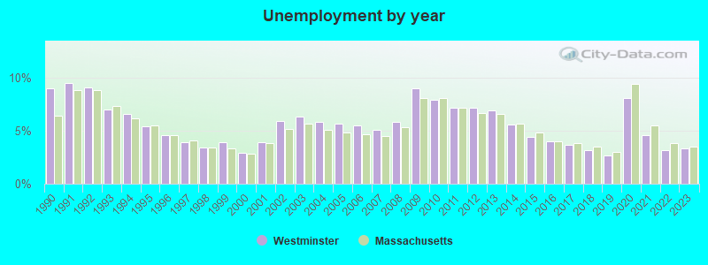
| Here: | 3.3% |
| Massachusetts: | 3.5% |
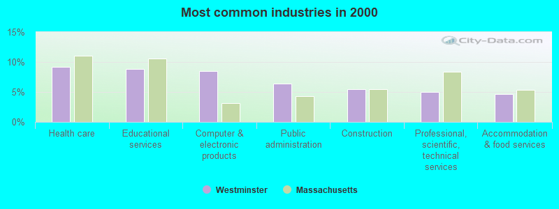
- Health care (9.2%)
- Educational services (8.8%)
- Computer & electronic products (8.5%)
- Public administration (6.4%)
- Construction (5.4%)
- Professional, scientific, technical services (5.0%)
- Accommodation & food services (4.6%)
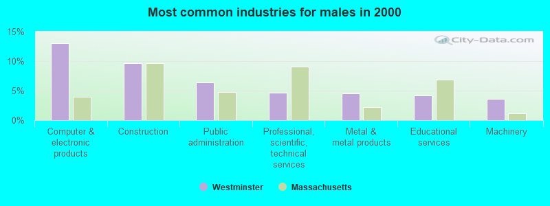
- Computer & electronic products (13.1%)
- Construction (9.6%)
- Public administration (6.4%)
- Professional, scientific, technical services (4.6%)
- Metal & metal products (4.5%)
- Educational services (4.2%)
- Machinery (3.6%)

- Health care (18.8%)
- Educational services (14.7%)
- Finance & insurance (7.6%)
- Accommodation & food services (7.2%)
- Public administration (6.5%)
- Professional, scientific, technical services (5.6%)
- Social assistance (3.6%)
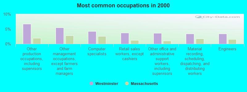
- Other production occupations, including supervisors (6.7%)
- Other management occupations, except farmers and farm managers (5.4%)
- Computer specialists (4.2%)
- Retail sales workers, except cashiers (3.7%)
- Other office and administrative support workers, including supervisors (3.6%)
- Material recording, scheduling, dispatching, and distributing workers (3.4%)
- Engineers (3.4%)
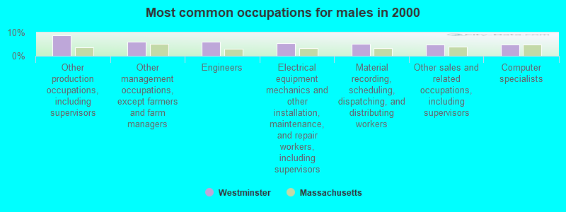
- Other production occupations, including supervisors (8.6%)
- Other management occupations, except farmers and farm managers (6.2%)
- Engineers (6.1%)
- Electrical equipment mechanics and other installation, maintenance, and repair workers, including supervisors (5.4%)
- Material recording, scheduling, dispatching, and distributing workers (5.2%)
- Other sales and related occupations, including supervisors (4.9%)
- Computer specialists (4.8%)

- Other office and administrative support workers, including supervisors (7.7%)
- Preschool, kindergarten, elementary, and middle school teachers (6.5%)
- Retail sales workers, except cashiers (6.3%)
- Secretaries and administrative assistants (4.8%)
- Other management occupations, except farmers and farm managers (4.5%)
- Registered nurses (4.5%)
- Other production occupations, including supervisors (4.3%)
Average climate in Westminster, Massachusetts
Based on data reported by over 4,000 weather stations


(lower is better)
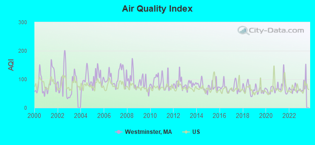
Air Quality Index (AQI) level in 2022 was 64.8. This is about average.
| City: | 64.8 |
| U.S.: | 72.6 |
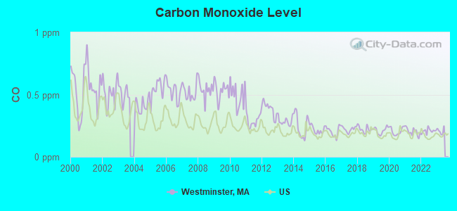
Carbon Monoxide (CO) [ppm] level in 2022 was 0.208. This is better than average. Closest monitor was 19.9 miles away from the city center.
| City: | 0.208 |
| U.S.: | 0.251 |
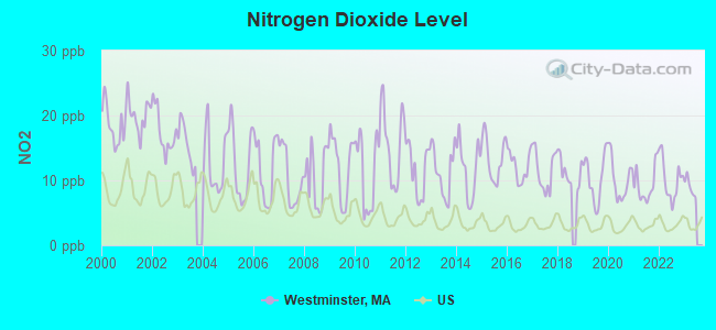
Nitrogen Dioxide (NO2) [ppb] level in 2022 was 10.1. This is significantly worse than average. Closest monitor was 5.7 miles away from the city center.
| City: | 10.1 |
| U.S.: | 5.1 |
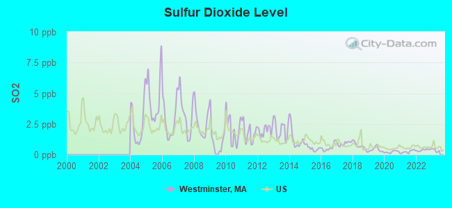
Sulfur Dioxide (SO2) [ppb] level in 2022 was 0.379. This is significantly better than average. Closest monitor was 4.1 miles away from the city center.
| City: | 0.379 |
| U.S.: | 1.515 |
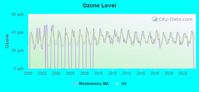
Ozone [ppb] level in 2022 was 33.3. This is about average. Closest monitor was 6.3 miles away from the city center.
| City: | 33.3 |
| U.S.: | 33.3 |

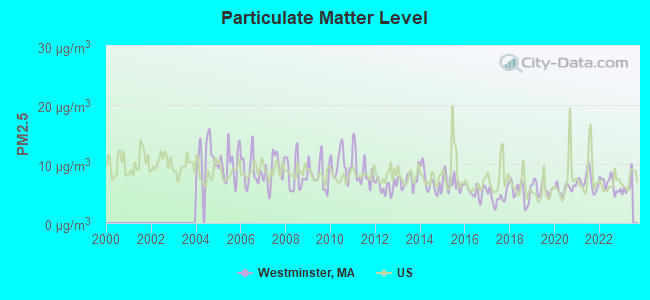
Particulate Matter (PM2.5) [µg/m3] level in 2022 was 6.58. This is better than average. Closest monitor was 6.7 miles away from the city center.
| City: | 6.58 |
| U.S.: | 8.11 |
Tornado activity:
Westminster-area historical tornado activity is slightly above Massachusetts state average. It is 17% smaller than the overall U.S. average.
On 6/9/1953, a category F4 (max. wind speeds 207-260 mph) tornado 14.6 miles away from the Westminster town center killed 90 people and injured 1228 people and caused between $50,000,000 and $500,000,000 in damages.
On 6/22/1981, a category F3 (max. wind speeds 158-206 mph) tornado 0.4 miles away from the town center injured 3 people and caused between $5000 and $50,000 in damages.
Earthquake activity:
Westminster-area historical earthquake activity is significantly above Massachusetts state average. It is 71% smaller than the overall U.S. average.On 10/7/1983 at 10:18:46, a magnitude 5.3 (5.1 MB, 5.3 LG, 5.1 ML, Class: Moderate, Intensity: VI - VII) earthquake occurred 156.8 miles away from the city center
On 4/20/2002 at 10:50:47, a magnitude 5.3 (5.3 ML, Depth: 3.0 mi) earthquake occurred 163.2 miles away from the city center
On 4/20/2002 at 10:50:47, a magnitude 5.2 (5.2 MB, 4.2 MS, 5.2 MW, 5.0 MW) earthquake occurred 162.3 miles away from the city center
On 1/19/1982 at 00:14:42, a magnitude 4.7 (4.5 MB, 4.7 MD, 4.5 LG, Class: Light, Intensity: IV - V) earthquake occurred 67.8 miles away from Westminster center
On 10/16/2012 at 23:12:25, a magnitude 4.7 (4.7 ML, Depth: 10.0 mi) earthquake occurred 96.3 miles away from the city center
On 10/2/1994 at 11:27:22, a magnitude 3.7 (3.5 LG, 3.7 LG, Depth: 6.2 mi, Class: Light, Intensity: II - III) earthquake occurred 23.5 miles away from Westminster center
Magnitude types: regional Lg-wave magnitude (LG), body-wave magnitude (MB), duration magnitude (MD), local magnitude (ML), surface-wave magnitude (MS), moment magnitude (MW)
Natural disasters:
The number of natural disasters in Worcester County (27) is a lot greater than the US average (15).Major Disasters (Presidential) Declared: 15
Emergencies Declared: 12
Causes of natural disasters: Floods: 9, Storms: 8, Hurricanes: 6, Snowstorms: 5, Winter Storms: 4, Blizzards: 2, Snows: 2, Fire: 1, Heavy Rain: 1, Snowfall: 1, Tornado: 1, Wind: 1 (Note: some incidents may be assigned to more than one category).
Hospitals and medical centers near Westminster:
- WACHUSETT MANOR (Nursing Home, about 5 miles away; GARDNER, MA)
- LEGEND REHABILITATION AND NURSING CENTER (Nursing Home, about 5 miles away; GARDNER, MA)
- GARDNER VNA (Home Health Center, about 5 miles away; GARDNER, MA)
- PHYSICIANS DIALYSIS INC., - FITCHBURG (Dialysis Facility, about 5 miles away; FITCHBURG, MA)
- SSC NORTH CENTRAL OPEARATING COMPANY LLC (Nursing Home, about 5 miles away; FITCHBURG, MA)
- GARDNER MANOR (Nursing Home, about 6 miles away; GARDNER, MA)
- GARDNER SKILLED NURSING CENTER (Nursing Home, about 6 miles away; GARDNER, MA)
Heliports located in Westminster:
See details about Heliports located in Westminster, MAColleges/universities with over 2000 students nearest to Westminster:
- Mount Wachusett Community College (about 6 miles; Gardner, MA; Full-time enrollment: 3,143)
- Fitchburg State University (about 7 miles; Fitchburg, MA; FT enrollment: 5,010)
- Quinsigamond Community College (about 17 miles; Worcester, MA; FT enrollment: 5,877)
- Assumption College (about 18 miles; Worcester, MA; FT enrollment: 2,580)
- Franklin Pierce University (about 19 miles; Rindge, NH; FT enrollment: 2,139)
- Worcester Polytechnic Institute (about 20 miles; Worcester, MA; FT enrollment: 3,930)
- Worcester State University (about 20 miles; Worcester, MA; FT enrollment: 5,426)
Private high school in Westminster:
Public elementary/middle schools in Westminster:
- WESTMINSTER ELEMENTARY (Students: 374, Location: 9 ACADEMY HILL, Grades: 2-5)
- MEETINGHOUSE SCHOOL (Students: 230, Location: 8 SOUTH STREET, Grades: KG-1)
Private elementary/middle school in Westminster:
Points of interest:
Notable locations in Westminster: Central Wharf (A), Westminster Country Club (B), Hatches Wharf (C), Hawkes House (D), Derby House (E), Custom House (F), Narbonne-Hale House (G), Central Wharf Warehouse Visitor Center (H), Westminster Fire Department Station 1 Headquarters (I), Westminster Town Hall (J), Westminster Historical Society Library (K), Westminster Historical Society Building (L), Forbush Memorial Library (M). Display/hide their locations on the map
Churches in Westminster include: Saint Edward the Confessor Church (A), Our Saviours Lutheran Church (B), First Congregational Church (C). Display/hide their locations on the map
Cemeteries: Mount Pleasant Cemetery (1), Woodside Cemetery (2). Display/hide their locations on the map
Lakes, reservoirs, and swamps: Rice Meadow Pond (A), Muddy Pond (B), Wyman Pond (C), Whitmanville Reservoir (D), Upper Reservoir (E), Round Meadow Pond (F), Partridge Pond (G), Noyes Pond (H). Display/hide their locations on the map
Streams, rivers, and creeks: Smith Brook (A). Display/hide its location on the map
Parks in Westminster include: Crow Hill State Reservation (1), Westminster Village-Academy Hill Historic District (2), Westminster State Forest (3), Haeger Park (4), Forrester (5). Display/hide their locations on the map
Hotel: Rodeway Inn Westminster (183 Main Street) (1). Display/hide its approximate location on the map
Birthplace of: Nelson A. Miles - Army Medal of Honor recipient and Union Army general, Frederick S. Coolidge - Politician, Marcus A. Coolidge - Politician, William H. Upham - Union Army soldier.
Drinking water stations with addresses in Westminster and their reported violations in the past:
WESTMINSTER DEPARTMENT OF PUBLIC WORKS (Population served: 3,294, Purch surface water):Past health violations:LEINO PARK WATER DISTRICT (Population served: 120, Purch surface water):Past monitoring violations:
- MCL, Monthly (TCR) - In JUL-2013, Contaminant: Coliform. Follow-up actions: St AO (w/o penalty) issued (SEP-09-2013)
- MCL, Average - Between APR-2008 and JUN-2008, Contaminant: TTHM. Follow-up actions: St AO (w/o penalty) issued (JUL-22-2008)
- MCL, Average - Between OCT-2007 and DEC-2007, Contaminant: TTHM. Follow-up actions: St AO (w/o penalty) issued (JAN-17-2008), St Compliance achieved (APR-10-2008)
- MCL, Average - Between JUL-2007 and SEP-2007, Contaminant: TTHM. Follow-up actions: St AO (w/o penalty) issued (OCT-29-2007), St Compliance achieved (APR-10-2008)
- MCL, Average - Between APR-2006 and JUN-2006, Contaminant: TTHM. Follow-up actions: St AO (w/o penalty) issued (SEP-19-2006), St Compliance achieved (NOV-16-2006)
- MCL, Average - Between JAN-2006 and MAR-2006, Contaminant: TTHM. Follow-up actions: St AO (w/o penalty) issued (JUL-03-2006), St Compliance achieved (JUL-03-2006)
- MCL, Average - Between OCT-2005 and DEC-2005, Contaminant: TTHM. Follow-up actions: St AO (w/o penalty) issued (JUL-03-2006), St Compliance achieved (JUL-03-2006)
- Follow-up Or Routine LCR Tap M/R - In OCT-01-2007, Contaminant: Lead and Copper Rule. Follow-up actions: St AO (w/o penalty) issued (NOV-21-2007), St Compliance achieved (DEC-07-2007)
Past health violations:HOLMES PARK WATER DISTRICT (Population served: 112, Purch surface water):Past monitoring violations:
- MCL, Average - Between JAN-2011 and MAR-2011, Contaminant: TTHM. Follow-up actions: St AO (w/o penalty) issued (APR-21-2011), St Compliance achieved (JUL-10-2011)
- MCL, Average - Between OCT-2010 and DEC-2010, Contaminant: TTHM. Follow-up actions: St AO (w/o penalty) issued (FEB-01-2011), St Compliance achieved (JUL-10-2011)
- MCL, Average - Between APR-2009 and JUN-2009, Contaminant: TTHM. Follow-up actions: St AO (w/o penalty) issued (JUL-23-2009), St Compliance achieved (OCT-02-2009)
- MCL, Average - Between JAN-2009 and MAR-2009, Contaminant: TTHM. Follow-up actions: St AO (w/o penalty) issued (APR-27-2009), St Compliance achieved (OCT-02-2009)
- MCL, Average - Between OCT-2008 and DEC-2008, Contaminant: TTHM. Follow-up actions: St AO (w/o penalty) issued (JAN-26-2009), St Compliance achieved (OCT-02-2009)
- MCL, Average - Between JUL-2008 and SEP-2008, Contaminant: TTHM. Follow-up actions: St AO (w/o penalty) issued (OCT-20-2008), St Compliance achieved (OCT-02-2009)
- 9 other older health violations
- Monitoring and Reporting (DBP) - Between OCT-2013 and DEC-2013, Contaminant: Total Haloacetic Acids (HAA5). Follow-up actions: St AO (w/o penalty) issued (MAR-13-2014), St Compliance achieved (MAR-17-2014)
- Monitoring and Reporting (DBP) - Between OCT-2013 and DEC-2013, Contaminant: TTHM. Follow-up actions: St AO (w/o penalty) issued (MAR-13-2014), St Compliance achieved (MAR-17-2014)
Past health violations:Past monitoring violations:
- MCL, Monthly (TCR) - In JAN-2011, Contaminant: Coliform. Follow-up actions: St AO (w/o penalty) issued (APR-29-2011)
- MCL, Monthly (TCR) - In OCT-2008, Contaminant: Coliform. Follow-up actions: St AO (w/o penalty) issued (DEC-22-2008), St Compliance achieved (DEC-22-2008)
- MCL, Average - Between APR-2007 and JUN-2007, Contaminant: TTHM. Follow-up actions: St AO (w/o penalty) issued (AUG-09-2007)
- Monitoring and Reporting (DBP) - Between JAN-2014 and MAR-2014, Contaminant: Chlorine. Follow-up actions: St AO (w/o penalty) issued (JUN-06-2014), St Compliance achieved (JUN-06-2014)
- Monitoring and Reporting (DBP) - Between OCT-2013 and DEC-2013, Contaminant: Chlorine. Follow-up actions: St AO (w/o penalty) issued (MAR-03-2014), St Compliance achieved (MAR-31-2014)
- Follow-up Or Routine LCR Tap M/R - In JUL-01-2013, Contaminant: Lead and Copper Rule. Follow-up actions: St AO (w/o penalty) issued (NOV-26-2013)
- Monitoring and Reporting (DBP) - Between JUL-2013 and SEP-2013, Contaminant: Chlorine. Follow-up actions: St AO (w/o penalty) issued (NOV-26-2013), St Compliance achieved (APR-30-2014)
- Monitoring and Reporting (DBP) - Between APR-2013 and JUN-2013, Contaminant: Chlorine. Follow-up actions: St AO (w/o penalty) issued (JUN-12-2013), St Compliance achieved (APR-30-2014)
- 4 routine major monitoring violations
- 7 other older monitoring violations
| This town: | 2.7 people |
| Massachusetts: | 2.5 people |
| This town: | 75.4% |
| Whole state: | 63.0% |
| This town: | 7.0% |
| Whole state: | 7.0% |
Likely homosexual households (counted as self-reported same-sex unmarried-partner households)
- Lesbian couples: 0.5% of all households
- Gay men: 0.3% of all households
| This town: | 3.1% |
| Whole state: | 9.3% |
| This town: | 1.3% |
| Whole state: | 4.4% |
For population 15 years and over in Westminster:
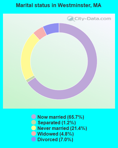
- Never married: 21.4%
- Now married: 65.7%
- Separated: 1.2%
- Widowed: 4.8%
- Divorced: 7.0%
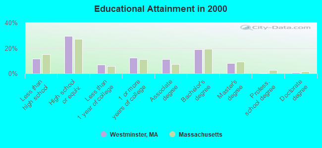
For population 25 years and over in Westminster:
- High school or higher: 88.4%
- Bachelor's degree or higher: 28.5%
- Graduate or professional degree: 9.3%
- Unemployed: 2.4%
- Mean travel time to work (commute): 28.7 minutes
| Here: | 10.1 |
| Massachusetts average: | 13.1 |


Graphs represent county-level data. Detailed 2008 Election Results
Religion statistics for Westminster, MA (based on Worcester County data)


| Religion | Adherents | Congregations |
|---|---|---|
| Catholic | 306,925 | 118 |
| Mainline Protestant | 43,326 | 171 |
| Evangelical Protestant | 37,511 | 203 |
| Other | 18,931 | 69 |
| Orthodox | 7,935 | 15 |
| Black Protestant | 497 | 6 |
| None | 383,427 | - |
Food Environment Statistics:
| This county: | 1.73 / 10,000 pop. |
| Massachusetts: | 1.98 / 10,000 pop. |
| Worcester County: | 0.05 / 10,000 pop. |
| Massachusetts: | 0.05 / 10,000 pop. |
| Worcester County: | 1.79 / 10,000 pop. |
| Massachusetts: | 2.22 / 10,000 pop. |
| Worcester County: | 2.22 / 10,000 pop. |
| Massachusetts: | 1.77 / 10,000 pop. |
| Worcester County: | 7.27 / 10,000 pop. |
| State: | 8.76 / 10,000 pop. |
| Here: | 8.0% |
| Massachusetts: | 8.1% |
| Here: | 24.0% |
| State: | 22.5% |
| This county: | 16.6% |
| Massachusetts: | 16.5% |
4.71% of this county's 2021 resident taxpayers lived in other counties in 2020 ($76,229 average adjusted gross income)
| Here: | 4.71% |
| Massachusetts average: | 6.35% |
0.02% of residents moved from foreign countries ($100 average AGI)
Worcester County: 0.02% Massachusetts average: 0.01%
Top counties from which taxpayers relocated into this county between 2020 and 2021:
| from Middlesex County, MA | |
| from Norfolk County, MA | |
| from Suffolk County, MA |
4.84% of this county's 2020 resident taxpayers moved to other counties in 2021 ($87,252 average adjusted gross income)
| Here: | 4.84% |
| Massachusetts average: | 7.18% |
0.03% of residents moved to foreign countries ($199 average AGI)
Worcester County: 0.03% Massachusetts average: 0.02%
Top counties to which taxpayers relocated from this county between 2020 and 2021:
| to Middlesex County, MA | |
| to Norfolk County, MA | |
| to Suffolk County, MA |
| Businesses in Westminster, MA | ||||
| Name | Count | Name | Count | |
|---|---|---|---|---|
| Circle K | 1 | Rodeway Inn | 1 | |
| Curves | 1 | Subway | 1 | |
| Dunkin Donuts | 2 | UPS | 1 | |
| FedEx | 1 | |||
Strongest AM radio stations in Westminster:
- WEIM (1280 AM; 5 kW; FITCHBURG, MA; Owner: LIVEAIR COMMUNICATIONS, INC.)
- WCRN (830 AM; 50 kW; WORCESTER, MA; Owner: CARTER BROADCASTING CORPORATION)
- WFGL (960 AM; 2 kW; FITCHBURG, MA; Owner: CSN INTERNATIONAL)
- WVNE (760 AM; daytime; 25 kW; LEICESTER, MA; Owner: BLOUNT MASSCOM, INC.)
- WRKO (680 AM; 50 kW; BOSTON, MA; Owner: ENTERCOM BOSTON LICENSE, LLC)
- WKOX (1200 AM; 50 kW; FRAMINGHAM, MA; Owner: CAPSTAR TX LIMITED PARTNERSHIP)
- WBIX (1060 AM; 40 kW; NATICK, MA; Owner: LANGER BROADCASTING CORPORATION)
- WEEI (850 AM; 50 kW; BOSTON, MA; Owner: ENTERCOM BOSTON LICENSE, LLC)
- WTAG (580 AM; 5 kW; WORCESTER, MA; Owner: CAPSTAR TX LIMITED PARTNERSHIP)
- WNNZ (640 AM; 50 kW; WESTFIELD, MA; Owner: CLEAR CHANNEL BROADCASTING LICENSES, INC.)
- WAMG (890 AM; 25 kW; DEDHAM, MA; Owner: MEGA COMMUNICATIONS OF DEDHAM LICENSEE, LLC)
- WALE (990 AM; 50 kW; GREENVILLE, RI; Owner: NORTH AMERICAN BROADCASTING CO., INC.)
- WGAW (1340 AM; 1 kW; GARDNER, MA; Owner: ANASTOS MEDIA GROUP, INC.)
Strongest FM radio stations in Westminster:
- WXLO (104.5 FM; FITCHBURG, MA; Owner: CITADEL BROADCASTING COMPANY)
- WAAF (107.3 FM; WORCESTER, MA; Owner: ENTERCOM BOSTON LICENSE, LLC)
- WFEX (92.1 FM; PETERBOROUGH, NH; Owner: FNX BROADCASTING OF NEW HAMPSHIRE LLC)
- WSRS (96.1 FM; WORCESTER, MA; Owner: CAPSTAR TX LIMITED PARTNERSHIP)
- WAHL (99.9 FM; ATHOL, MA; Owner: CITADEL BROADCASTING COMPANY)
- WINQ (97.7 FM; WINCHENDON, MA; Owner: SAGA COMMUNICATIONS OF NEW ENGLAND, LLC)
- WFCR (88.5 FM; AMHERST, MA; Owner: UNIVERSITY OF MASSACHUSETTS)
- WGIR-FM (101.1 FM; MANCHESTER, NH; Owner: CAPSTAR TX LIMITED PARTNERSHIP)
- WBMX (98.5 FM; BOSTON, MA; Owner: INFINITY RADIO OPERATIONS INC.)
- WHDQ (106.1 FM; CLAREMONT, NH; Owner: GREAT NORTHERN RADIO, L.L.C.)
- WJMN (94.5 FM; BOSTON, MA; Owner: AMFM RADIO LICENSES, L.L.C.)
- WCRB (102.5 FM; WALTHAM, MA; Owner: CHARLES RIVER BROADCASTING WCRB LICE)
- WTKK (96.9 FM; BOSTON, MA; Owner: GREATER BOSTON RADIO, INC.)
- WROR-FM (105.7 FM; FRAMINGHAM, MA; Owner: GREATER BOSTON RADIO, INC.)
- WBOS (92.9 FM; BROOKLINE, MA; Owner: GREATER BOSTON RADIO, INC.)
- WQLL (96.5 FM; BEDFORD, NH; Owner: SAGA COMMUNICATIONS OF NEW ENGLAND, LLC)
- WLMW (90.7 FM; MANCHESTER, NH; Owner: KNOWLEDGE FOR LIFE)
- WGBH (89.7 FM; BOSTON, MA; Owner: WGBH EDUCATIONAL FOUNDATION)
- WZID (95.7 FM; MANCHESTER, NH; Owner: SAGA COMMUNICATIONS OF NEW ENGLAND, LLC)
- WAMH (89.3 FM; AMHERST, MA; Owner: TRUSTEES OF AMHERST COLLEGE)
TV broadcast stations around Westminster:
- WUNI (Channel 27; WORCESTER, MA; Owner: ENTRAVISION HOLDINGS, LLC)
- WUTF (Channel 66; MARLBOROUGH, MA; Owner: TELEFUTURA BOSTON LLC)
- WCVB-TV (Channel 5; BOSTON, MA; Owner: WCVB HEARST-ARGYLE TV, INC.)
- WGBH-TV (Channel 2; BOSTON, MA; Owner: WGBH EDUCATIONAL FOUNDATION)
- WYDN (Channel 48; WORCESTER, MA; Owner: EDUCATIONAL PUBLIC TV CORPORATION)
- WHDH-TV (Channel 7; BOSTON, MA; Owner: WHDH-TV)
- WMFP (Channel 62; LAWRENCE, MA; Owner: WSAH LICENSE, INC.)
- WBZ-TV (Channel 4; BOSTON, MA; Owner: VIACOM INC.)
- WGBX-TV (Channel 44; BOSTON, MA; Owner: WGBH EDUCATIONAL FOUNDATION)
- WSBK-TV (Channel 38; BOSTON, MA; Owner: VIACOM INC.)
- WLVI-TV (Channel 56; CAMBRIDGE, MA; Owner: WLVI, INC.)
- WFXT (Channel 25; BOSTON, MA; Owner: FOX TELEVISION STATIONS INC.)
- W40BO (Channel 40; BOSTON, MA; Owner: PAXSON COMMUNICATIONS LPTV, INC.)
- WBPX (Channel 68; BOSTON, MA; Owner: PAXSON BOSTON-68 LICENSE, INC.)
- WFXZ-CA (Channel 24; BOSTON, MA; Owner: BOSTON BROADCASTING CORP.)
- WNDS (Channel 50; DERRY, NH; Owner: CTV OF DERRY, INC)
- WCRN-LP (Channel 34; LEICESTER, MA; Owner: CARTER BROADCASTING CORPORATION)
Medal of Honor Recipients
Medal of Honor Recipient born in Westminster: Nelson A. Miles.
- National Bridge Inventory (NBI) Statistics
- 19Number of bridges
- 148ft / 44.8mTotal length
- $21,927,000Total costs
- 145,582Total average daily traffic
- 11,410Total average daily truck traffic
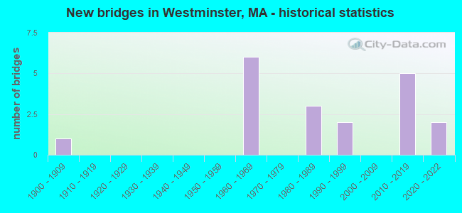
- New bridges - historical statistics
- 11900-1909
- 61960-1969
- 31980-1989
- 21990-1999
- 52010-2019
- 22020-2022
FCC Registered Antenna Towers:
7- Christopher J Mahoney, 23 Village Inn Road (Lat: 42.544167 Lon: -71.873583), Type: 50.6, Overall height: 50.6 m, Registrant: National Grid Communications, Martin.Cohen@gridcom.Com, , Westb-orough, Phone: (508) 389-3000
- Christopher F Ciolfi, 23 Village Inn Road (Lat: 42.544167 Lon: -71.873583), Type: 50.6, Overall height: 50.6 m, Registrant: National Grid Communications, Martin.Cohen@gridcom.Com, , Westb-orough, Phone: (508) 389-3000
- Christopher F Ciolfi, 23 Village Inn Road (Lat: 42.544167 Lon: -71.873583), Type: 50.6, Overall height: 50.6 m, Registrant: National Grid Communications, Laura.Room@us.Ngridwireless.Com, , Boxbo-rough, Phone: (978) 264-6030
- Dan Menser, 23 Village Inn Road (Lat: 42.544167 Lon: -71.873583), Type: 50.6, Overall height: 50.6 m, Registrant: Omnipoint Holdings, Inc, Dan.Menser@voicestream.Com, , Belle-vue, Phone: (425) 378-4000
- Edward G Roach, 23 Village Inn Road (Lat: 42.544167 Lon: -71.873583), Type: 50.6, Overall height: 50.6 m, Registrant: Sba Towers Ii LLC, Eroach@sbasite.Com, , Boca -Raton, Phone: (561) 995-7670
- Edward G Roach, 23 Village Inn Rd (Ma13740-A) (Lat: 42.544306 Lon: -71.873583), Type: 50.3, Structure height: 25027 m, Overall height: 50.3 m, Registrant: Sba Towers Ii LLC, Eroach@sbasite.Com, , Boca -Raton, Phone: (561) 995-7670
- Edward G Roach, 23 Village Inn Rd (Ma13740-A) (Lat: 42.544306 Lon: -71.873583), Type: 50.3, Structure height: 25027 m, Overall height: 50.3 m, Registrant: Sba Towers Ii LLC, Eroach@sbasite.Com, , Boca -Raton, Phone: (561) 995-7670
FCC Registered Broadcast Land Mobile Towers:
6- Lat: 42.548694 Lon: -71.927000, Call Sign: WQCP431,
Assigned Frequencies: 458.137 MHz, Grant Date: 02/04/2015, Expiration Date: 04/22/2025, Certifier: William D Ahearn, Registrant: Public Works Department, 2 Oakmont Ave, Westminster, MA 01473-1021, Phone: (978) 874-2933, Fax: (978) 874-5572, Email:
- Lat: 42.537500 Lon: -71.915083, Call Sign: WQEE393,
Assigned Frequencies: 458.987 MHz, Grant Date: 11/13/2015, Expiration Date: 01/06/2026, Certifier: Brenton Macaloney, Registrant: David Westcott, 6 Pequot Way, Canton, MA 02021, Phone: (781) 828-1955, Fax: (781) 828-3719, Email:
- Call Sign: WQFU482,
Assigned Frequencies: 462.237 MHz, 462.387 MHz, 463.312 MHz, 468.312 MHz, Grant Date: 09/23/2016, Expiration Date: 10/05/2026, Certifier: Stefaan Sercu, Registrant: Bracewell LLP, 2001 M Street Nw, Suite 900, Washington, DC 20036, Phone: (202) 828-5828, Email:
- 50 Technology Drive (Lat: 42.558889 Lon: -71.921444), Type: Mast, Structure height: 15.8 m, Overall height: 17.3 m, Call Sign: WQKJ916,
Assigned Frequencies: 72.1400 MHz, Grant Date: 06/17/2009, Expiration Date: 06/17/2019, Cancellation Date: 08/17/2019, Certifier: David Olivani, Registrant: Primex Wireless,Inc., 965 Wells Street, Lake Geneva, WI 53147, Phone: (262) 249-2344
- Lat: 42.547528 Lon: -71.903611, Call Sign: WQYU959,
Assigned Frequencies: 464.862 MHz, 469.862 MHz, Grant Date: 01/30/2017, Expiration Date: 01/30/2027, Certifier: John Applin, Registrant: Worad, Inc., 299 Brooks Street, Worcester, MA 01606, Phone: (508) 852-2693, Fax: (508) 852-2704, Email:
- L2 MOBILES, 155 Turnpike Rd (Lat: 42.553639 Lon: -71.855806), Call Sign: WQZU356, Licensee ID: L00003681,
Assigned Frequencies: 161.310 MHz, 160.350 MHz, 161.160 MHz, 161.400 MHz, 161.250 MHz, 160.230 MHz, 160.440 MHz, Grant Date: 08/04/2017, Expiration Date: 08/04/2027, Certifier: Timothy R Kunzler, Registrant: Csx Transportation Inc, 6735 Southpoint Dr S, Suite 400, Jacksonville, FL 32216, Phone: (904) 279-6938, Email:
FCC Registered Microwave Towers:
6- STATION, Lat: 42.583417 Lon: -71.882833, Overall height: 6.1 m, Call Sign: WNTR641,
Assigned Frequencies: 952.781 MHz, Grant Date: 08/06/1998, Expiration Date: 10/12/2008, Cancellation Date: 08/23/1999, Phone: (508) 366-9011
- Westminster, Lat: 42.583417 Lon: -71.882861, Call Sign: WPQY752,
Assigned Frequencies: 952.406 MHz, Grant Date: 10/28/2020, Expiration Date: 12/05/2030, Certifier: Chris Kelly, Registrant: Utilties Technology Council, 2550 South Clark St., Suite 960, Arlington, VA 22202, Phone: (202) 872-0030, Fax: (202) 872-1331, Email:
- WESTMINSTER, Lat: 42.530556 Lon: -71.891389, Call Sign: WQHZ423,
Assigned Frequencies: 952.568 MHz, Grant Date: 02/28/2018, Expiration Date: 12/04/2027, Certifier: Christopher Mcgown, Registrant: Town Of Clinton, 242 Church St, Clinton, MA 01510, Phone: (978) 365-4110, Fax: (978) 365-4106, Email:
- 4WL0751E (WOR061), 23 Village Inn Road (Lat: 42.544167 Lon: -71.873583), Type: Pole, Structure height: 50.6 m, Call Sign: WQJW809,
Assigned Frequencies: 17815.0 MHz, Grant Date: 01/27/2009, Expiration Date: 01/27/2019, Cancellation Date: 03/10/2017, Certifier: Dan Menser, Registrant: T-Mobile License LLC, 12920 Se 38th Street, Bellevue, WA 98006, Phone: (425) 383-8401, Fax: (425) 383-4840, Email:
- Ellis Road Tank, Ellis Road (Lat: 42.541528 Lon: -71.922556), Type: Tank, Structure height: 24.4 m, Overall height: 26.8 m, Call Sign: WRAQ754, Licensee ID: L00033887,
Assigned Frequencies: 17980.0 MHz, 18060.0 MHz, 17980.0 MHz, 18060.0 MHz, 17980.0 MHz, 18060.0 MHz, 17980.0 MHz, 18060.0 MHz, 17980.0 MHz, 18060.0 MHz, 17980.0 MHz, 18060.0 MHz, Grant Date: 01/31/2018, Expiration Date: 01/31/2028, Certifier: Salvatore Albert, Registrant: Westminster Police, 7 South Street, Westminster, MA 01473, Phone: (978) 874-2933, Fax: (978) 874-5432, Email:
- DPW Tower, 11 Oakmont Ave (Lat: 42.561472 Lon: -71.905917), Type: Ltower, Structure height: 36.6 m, Overall height: 39 m, Call Sign: WRAQ756, Licensee ID: L00033887,
Assigned Frequencies: 17820.0 MHz, 17900.0 MHz, 17820.0 MHz, 17900.0 MHz, 17820.0 MHz, 17900.0 MHz, 17820.0 MHz, 17900.0 MHz, 17820.0 MHz, 17900.0 MHz, 17820.0 MHz, 17900.0 MHz, Grant Date: 01/31/2018, Expiration Date: 01/31/2028, Certifier: Salvatore Albert, Registrant: Westminster Police, 7 South Street, Westminster, MA 01473, Phone: (978) 874-2933, Fax: (978) 874-5432, Email:
FCC Registered Amateur Radio Licenses:
47 (See the full list of FCC Registered Amateur Radio Licenses in Westminster)FAA Registered Aircraft:
5- Aircraft: PIPER PA-28-180 (Category: Land, Seats: 4, Weight: Up to 12,499 Pounds, Speed: 107 mph), Engine: LYCOMING O&VO-360 SER (180 HP) (Reciprocating)
N-Number: 15975, N15975, N-15975, Serial Number: 28-7305226, Year manufactured: 1973, Airworthiness Date: 01/19/1973, Certificate Issue Date: 06/15/2020
Registrant (Individual): David Bourgeois, 314 W Princeton Rd, Westminster, MA 01473 - Aircraft: CESSNA 210L (Category: Land, Seats: 6, Weight: Up to 12,499 Pounds, Speed: 87 mph), Engine: CONT MOTOR IO 520 SERIES (285 HP) (Reciprocating)
N-Number: 210DG, N210DG, N-210DG, Serial Number: 21059559, Year manufactured: 1972, Airworthiness Date: 01/31/1972, Certificate Issue Date: 09/26/1996
Registrant (Co-Owned): Stig K Washburn, 173 South St, Westminster, MA 01473, Other Owners: Richard J Plehn - Aircraft: TAYLORCRAFT BC12-D (Category: Land, Seats: 2, Weight: Up to 12,499 Pounds, Speed: 78 mph), Engine: CONT MOTOR A&C65 SERIES (65 HP) (Reciprocating)
N-Number: 43066, N43066, N-43066, Serial Number: 6725, Year manufactured: 1946, Certificate Issue Date: 11/30/2018
Registrant (Individual): David F Leblanc, 78 Barthrick Rd, Westminster, MA 01473 - Aircraft: AMERICAN AA-1B (Category: Land, Seats: 2, Weight: Up to 12,499 Pounds, Speed: 108 mph), Engine: LYCOMING 0-235 SERIES (115 HP) (Reciprocating)
N-Number: 6211L, N6211L, N-6211L, Serial Number: AA1B-0011, Year manufactured: 1972, Airworthiness Date: 08/29/1972, Certificate Issue Date: 08/18/2020
Registrant (Individual): Eric J Steigelman, 38 Newton Rd, Westminster, MA 01473 - Aircraft: CESSNA 150M (Category: Land, Seats: 2, Weight: Up to 12,499 Pounds, Speed: 81 mph), Engine: CONT MOTOR 0-200 SERIES (100 HP) (4 Cycle)
N-Number: 704SU, N704SU, N-704SU, Serial Number: 15078845, Year manufactured: 1976, Airworthiness Date: 10/14/1976, Certificate Issue Date: 08/25/2005
Registrant (Individual): Leonard Weiser, 194 S Ashburnham Rd, Westminster, MA 01473
2002 - 2018 National Fire Incident Reporting System (NFIRS) incidents
- Fire incident types reported to NFIRS in Westminster, MA
- 24443.6%Structure Fires
- 18032.2%Outside Fires
- 12121.6%Mobile Property/Vehicle Fires
- 142.5%Other
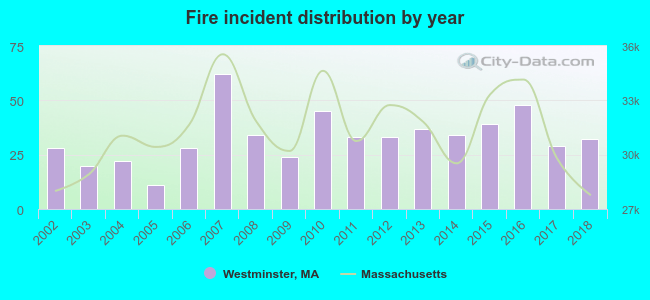 Based on the data from the years 2002 - 2018 the average number of fire incidents per year is 33. The highest number of reported fire incidents - 62 took place in 2007, and the least - 11 in 2005. The data has a growing trend.
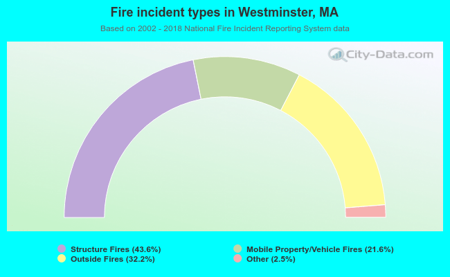 When looking into fire subcategories, the most reports belonged to: Structure Fires (43.6%), and Outside Fires (32.2%).
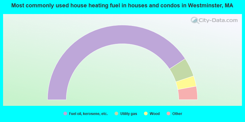
- 81.5%Fuel oil, kerosene, etc.
- 8.2%Utility gas
- 4.5%Wood
- 3.2%Electricity
- 2.5%Bottled, tank, or LP gas
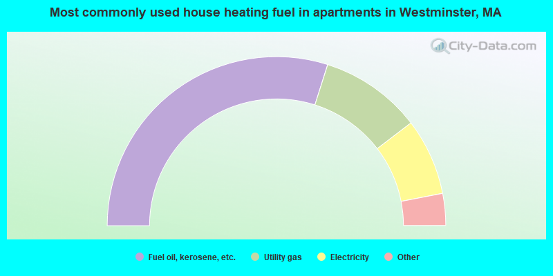
- 59.8%Fuel oil, kerosene, etc.
- 19.4%Utility gas
- 14.7%Electricity
- 2.2%Other fuel
- 1.9%Bottled, tank, or LP gas
- 1.9%Wood
Westminster compared to Massachusetts state average:
- Unemployed percentage significantly below state average.
- Black race population percentage significantly below state average.
- Hispanic race population percentage significantly below state average.
- Foreign-born population percentage significantly below state average.
- Renting percentage significantly below state average.
- Length of stay since moving in significantly above state average.
- Number of rooms per house significantly below state average.
- House age significantly below state average.
Westminster on our top lists:
- #4 on the list of "Top 101 cities with largest percentage of females in occupations: special education teachers (population 5,000+)"
- #8 on the list of "Top 101 cities with largest percentage of males in industries: radio, tv, and computer stores (population 5,000+)"
- #9 on the list of "Top 101 cities with the lowest number of auto thefts per 100,000 residents (population 5,000+)"
- #9 on the list of "Top 101 cities with largest percentage of females in industries: lumber and other construction materials merchant wholesalers (population 5,000+)"
- #18 on the list of "Top 101 cities with largest percentage of males in industries: computer and electronic products (population 5,000+)"
- #24 on the list of "Top 101 cities with largest percentage of males in industries: lumber and other construction materials merchant wholesalers (population 5,000+)"
- #31 on the list of "Top 101 cities with largest percentage of males in industries: furniture and related product manufacturing (population 5,000+)"
- #35 on the list of "Top 101 cities with largest percentage of males in occupations: woodworkers (population 5,000+)"
- #42 on the list of "Top 101 cities with largest percentage of males in occupations: other teachers and instructors, education, training, and library occupations (population 5,000+)"
- #49 on the list of "Top 101 cities with largest percentage of males in occupations: social scientists and related workers (population 5,000+)"
- #50 on the list of "Top 101 cities with largest percentage of females in occupations: retail sales workers except cashiers (population 5,000+)"
- #50 on the list of "Top 101 cities with largest percentage of females in industries: plastics and rubber products (population 5,000+)"
- #53 on the list of "Top 101 cities with largest percentage of males in occupations: other transportation workers (population 5,000+)"
- #57 on the list of "Top 101 cities with largest percentage of females in industries: radio, tv, and computer stores (population 5,000+)"
- #59 on the list of "Top 101 cities with largest percentage of females in industries: sewing, needlework, and piece goods stores (population 5,000+)"
- #64 on the list of "Top 101 cities with largest percentage of males in industries: private households (population 5,000+)"
- #64 on the list of "Top 101 cities with largest percentage of females in industries: truck transportation (population 5,000+)"
- #66 on the list of "Top 101 cities with largest percentage of males in industries: plastics and rubber products (population 5,000+)"
- #77 on the list of "Top 101 cities with largest percentage of males in industries: u. s. postal service (population 5,000+)"
- #89 on the list of "Top 101 cities with largest percentage of males in industries: music stores (population 5,000+)"
- #4 on the list of "Top 101 counties with the highest carbon monoxide air pollution readings in 2012 (ppm)"
- #5 on the list of "Top 101 counties with the most Catholic congregations"
- #12 on the list of "Top 101 counties with the highest surface withdrawal of fresh water for public supply"
- #16 on the list of "Top 101 counties with the highest total withdrawal of fresh water for public supply"
- #23 on the list of "Top 101 counties with the highest Sulfur Oxides Annual air pollution readings in 2012 (µg/m3)"

|
|
Total of 156 patent applications in 2008-2024.