Bridge Statistics for Apopka, Florida (FL)
Condition, Traffic, Stress, Structural Evaluation, Project Costs
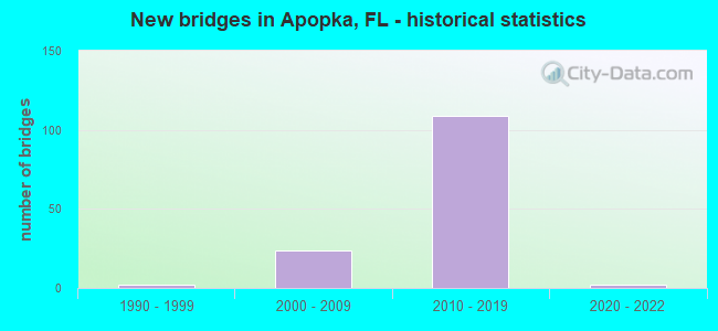
- New bridges - historical statistics
- 21990-1999
- 242000-2009
- 1092010-2019
- 22020-2022


- Bridge Condition - Deck
- 1.4%Excellent
- 69.0%Very good
- 16.9%Good
- 12.7%Satisfactory

- Bridge Condition - Superstructure
- 2.8%Excellent
- 80.3%Very good
- 16.9%Good

- Bridge Condition - Substructure
- 2.8%Excellent
- 87.3%Very good
- 9.9%Good

- Bridge Condition - Channel
- 60.0%Very good
- 40.0%Good
Find on map >> Show street view
Structure Number: 750854, Location: 0.4 Mile N of US-441 (Lat: 28.700083, Lng: -81.559000), Route carried "on" structure: State highway 429, Year Built: 2016, Status: Open, Structure Length: 2.37m (7.78ft), Average Daily Traffic: 6,650 (year 2020), Truck Traffic: 6%, Average Future Daily Traffic: 11,538 (year 2042), Design Load: HL 93, Features Intersected: Southfork Drive
Minimum Vertical Clearance: 30.45m (99.90ft), Kilometerpoint: 0.256, Lanes on structure: 2, Lanes under structure: 2, Base Highway Network: Yes, Toll: On toll road, Owner: State Toll Authority, Approaching Roadway Width: 12.3m (40.4ft), Material/Design: Prestressed concrete, Design/Construction: Stringer/Multi-beam, Number Of Spans In Main Unit: 1, Length of Maximum Span: 23.1m (75.8ft), Curb-To-Curb Width: 12.3m (40.4ft), Out-to-Out Width: 13.2m (43.3ft)
Condition: Deck: Very good, Superstructure: Very good, Substructure: Very good, Operating Rating: 50.3 metric tons, Method Used To Determine Operating Rating: Load and Resistance Factor (LRFR), Inventory Rating: 38.2 metric tons, Method Used To Determine Inventory Rating: Load and Resistance Factor (LRFR), Structural Evaluation: Equal to present desirable criteria, Deck Geometry: Better than present minimum criteria, Underclear: Superior to present desirable criteria, Approach Roadway Alignment: Equal to present desirable criteria, Designated Inspection Frequency: Every 24 months, Inspection Date: April 2021, Deck Structure Type: Concrete Cast-file-Place
Find on map >> Show street view
Structure Number: 750855, Location: 0.4 Mile N of US-441 (Lat: 28.700081, Lng: -81.559586), Route carried "on" structure: Ramp State highway 429, Year Built: 2016, Status: Open, Structure Length: 2.36m (7.74ft), Average Daily Traffic: 500 (year 2020), Truck Traffic: 7%, Average Future Daily Traffic: 868 (year 2042), Design Load: HL 93, Features Intersected: Southfork Drive
Minimum Vertical Clearance: 30.18m (99.02ft), Kilometerpoint: 0.140, Lanes on structure: 2, Lanes under structure: 2, Toll: On toll road, Owner: State Toll Authority, Approaching Roadway Width: 12.4m (40.7ft), Material/Design: Prestressed concrete, Design/Construction: Stringer/Multi-beam, Number Of Spans In Main Unit: 2, Length of Maximum Span: 23.0m (75.5ft), Curb-To-Curb Width: 12.4m (40.7ft), Out-to-Out Width: 13.3m (43.6ft)
Condition: Deck: Very good, Superstructure: Good, Substructure: Very good, Operating Rating: 54.2 metric tons, Method Used To Determine Operating Rating: Load and Resistance Factor (LRFR), Inventory Rating: 41.2 metric tons, Method Used To Determine Inventory Rating: Load and Resistance Factor (LRFR), Structural Evaluation: Better than present minimum criteria, Deck Geometry: Superior to present desirable criteria, Underclear: Better than present minimum criteria, Approach Roadway Alignment: Equal to present desirable criteria, Designated Inspection Frequency: Every 24 months, Inspection Date: April 2021, Deck Structure Type: Concrete Cast-file-Place
Find on map >> Show street view
Structure Number: 750856, Location: 0.4 Mile N of US-441 (Lat: 28.700092, Lng: -81.558797), Route carried "on" structure: Ramp State highway 429, Year Built: 2016, Status: Open, Structure Length: 2.94m (9.65ft), Average Daily Traffic: 500 (year 2020), Truck Traffic: 6%, Average Future Daily Traffic: 868 (year 2042), Design Load: HL 93, Features Intersected: Southfork Drive
Minimum Vertical Clearance: 30.18m (99.02ft), Kilometerpoint: 0.177, Lanes on structure: 1, Lanes under structure: 2, Toll: On toll road, Owner: State Toll Authority, Approaching Roadway Width: 8.3m (27.2ft), Material/Design: Prestressed concrete, Design/Construction: Stringer/Multi-beam, Number Of Spans In Main Unit: 1, Length of Maximum Span: 28.8m (94.5ft), Curb-To-Curb Width: 8.3m (27.2ft), Out-to-Out Width: 9.2m (30.2ft)
Condition: Deck: Very good, Superstructure: Very good, Substructure: Very good, Operating Rating: 46.7 metric tons, Method Used To Determine Operating Rating: Load and Resistance Factor (LRFR), Inventory Rating: 36.9 metric tons, Method Used To Determine Inventory Rating: Load and Resistance Factor (LRFR), Structural Evaluation: Equal to present desirable criteria, Deck Geometry: Superior to present desirable criteria, Underclear: Superior to present desirable criteria, Approach Roadway Alignment: Equal to present desirable criteria, Designated Inspection Frequency: Every 24 months, Inspection Date: April 2021, Deck Structure Type: Concrete Cast-file-Place
Find on map >> Show street view
Structure Number: 750857, Location: 0.6 Mi. North of US-441 (Lat: 28.704167, Lng: -81.559500), Route carried "on" structure: State highway 429, Year Built: 2016, Status: Open, Structure Length: 18.67m (61.25ft), Average Daily Traffic: 6,650 (year 2020), Truck Traffic: 6%, Average Future Daily Traffic: 11,538 (year 2042), Design Load: HL 93, Features Intersected: Low Area
Minimum Vertical Clearance: 30.18m (99.02ft), Kilometerpoint: 0.624, Lanes on structure: 2, Base Highway Network: Yes, Toll: On toll road, Owner: State Toll Authority, Approaching Roadway Width: 12.3m (40.4ft), Material/Design: Prestressed concrete, Design/Construction: Stringer/Multi-beam, Number Of Spans In Main Unit: 6, Length of Maximum Span: 31.1m (102.0ft), Curb-To-Curb Width: 12.3m (40.4ft), Out-to-Out Width: 13.2m (43.3ft)
Condition: Deck: Very good, Superstructure: Very good, Substructure: Very good, Operating Rating: 57.8 metric tons, Method Used To Determine Operating Rating: Load and Resistance Factor (LRFR), Inventory Rating: 43.7 metric tons, Method Used To Determine Inventory Rating: Load and Resistance Factor (LRFR), Structural Evaluation: Equal to present desirable criteria, Deck Geometry: Better than present minimum criteria, Approach Roadway Alignment: Equal to present desirable criteria, Designated Inspection Frequency: Every 24 months, Inspection Date: July 2021, Deck Structure Type: Concrete Cast-file-Place
Find on map >> Show street view
Structure Number: 750858, Location: 0.6Mi. North of US-441 (Lat: 28.704167, Lng: -81.559222), Route carried "on" structure: State highway 429, Year Built: 2016, Status: Open, Structure Length: 18.67m (61.25ft), Average Daily Traffic: 6,650 (year 2020), Truck Traffic: 6%, Average Future Daily Traffic: 11,538 (year 2042), Design Load: HL 93, Features Intersected: Low Area
Minimum Vertical Clearance: 30.18m (99.02ft), Kilometerpoint: 0.624, Lanes on structure: 2, Base Highway Network: Yes, Toll: On toll road, Owner: State Toll Authority, Approaching Roadway Width: 15.9m (52.2ft), Material/Design: Prestressed concrete, Design/Construction: Stringer/Multi-beam, Number Of Spans In Main Unit: 6, Length of Maximum Span: 31.1m (102.0ft), Curb-To-Curb Width: 15.9m (52.2ft), Out-to-Out Width: 16.8m (55.1ft)
Condition: Deck: Very good, Superstructure: Very good, Substructure: Very good, Operating Rating: 53.2 metric tons, Method Used To Determine Operating Rating: Load and Resistance Factor (LRFR), Inventory Rating: 37.9 metric tons, Method Used To Determine Inventory Rating: Load and Resistance Factor (LRFR), Structural Evaluation: Equal to present desirable criteria, Deck Geometry: Superior to present desirable criteria, Approach Roadway Alignment: Equal to present desirable criteria, Designated Inspection Frequency: Every 24 months, Inspection Date: July 2021, Deck Structure Type: Concrete Cast-file-Place
Find on map >> Show street view
Structure Number: 750859, Location: 0.92Mi N of US-441 (Lat: 28.708175, Lng: -81.560011), Route carried "on" structure: County highway 429, Year Built: 2016, Status: Open, Structure Length: 6.08m (19.95ft), Average Daily Traffic: 375 (year 2016), Truck Traffic: 5%, Average Future Daily Traffic: 651 (year 2038), Design Load: HL 93, Features Intersected: SR-429, Facility Carried by Structure: Belgian Street
Minimum Vertical Clearance: 30+ m (98+ ft), Kilometerpoint: 0.000, Lanes on structure: 2, Lanes under structure: 4, Owner: State Toll Authority, Approaching Roadway Width: 8.2m (26.9ft), Skew: 1 degrees, Material/Design: Prestressed concrete, Design/Construction: Stringer/Multi-beam, Number Of Spans In Main Unit: 2, Length of Maximum Span: 30.4m (99.7ft), Curb or Sidewalk Widths: Left: 1.8m (5.9ft), Right: 1.8m (5.9ft), Curb-To-Curb Width: 8.2m (26.9ft), Out-to-Out Width: 12.4m (40.7ft)
Condition: Deck: Very good, Superstructure: Excellent, Substructure: Excellent, Operating Rating: 43.1 metric tons, Method Used To Determine Operating Rating: Load and Resistance Factor (LRFR), Inventory Rating: 36.9 metric tons, Method Used To Determine Inventory Rating: Load and Resistance Factor (LRFR), Structural Evaluation: Superior to present desirable criteria, Deck Geometry: Somewhat better than minimum adequacy, Underclear: Better than present minimum criteria, Approach Roadway Alignment: Better than present minimum criteria, Designated Inspection Frequency: Every 24 months, Inspection Date: November 2020, Deck Structure Type: Concrete Cast-file-Place
Find on map >> Show street view
Structure Number: 750861, Location: 2.7 Miles N/O US-441 (Lat: 28.727472, Lng: -81.563500), Route carried "on" structure: State highway 429, Year Built: 2016, Status: Open, Structure Length: 4.43m (14.53ft), Average Daily Traffic: 6,650 (year 2020), Truck Traffic: 6%, Average Future Daily Traffic: 11,538 (year 2042), Design Load: HL 93, Features Intersected: Ponkan Road
Minimum Vertical Clearance: 30+ m (98+ ft), Kilometerpoint: 3.323, Lanes on structure: 2, Lanes under structure: 2, Base Highway Network: Yes, Toll: On toll road, Owner: State Toll Authority, Approaching Roadway Width: 12.6m (41.3ft), Material/Design: Prestressed concrete, Design/Construction: Box Beam or Girders - Single/Spread, Number Of Spans In Main Unit: 1, Length of Maximum Span: 43.6m (143.0ft), Curb-To-Curb Width: 12.6m (41.3ft), Out-to-Out Width: 13.1m (43.0ft)
Condition: Deck: Very good, Superstructure: Very good, Substructure: Very good, Operating Rating: 49.0 metric tons, Method Used To Determine Operating Rating: Load and Resistance Factor (LRFR), Inventory Rating: 45.1 metric tons, Method Used To Determine Inventory Rating: Load and Resistance Factor (LRFR), Structural Evaluation: Equal to present desirable criteria, Deck Geometry: Better than present minimum criteria, Underclear: Superior to present desirable criteria, Approach Roadway Alignment: Equal to present desirable criteria, Designated Inspection Frequency: Every 24 months, Inspection Date: April 2021, Deck Structure Type: Concrete Cast-file-Place
Find on map >> Show street view
Structure Number: 750862, Location: 2.7 Miles N/O US-441 (Lat: 28.727472, Lng: -81.563111), Route carried "on" structure: State highway 429, Year Built: 2016, Status: Open, Structure Length: 4.43m (14.53ft), Average Daily Traffic: 6,650 (year 2020), Truck Traffic: 6%, Average Future Daily Traffic: 11,538 (year 2042), Design Load: HL 93, Features Intersected: Ponkan Road
Minimum Vertical Clearance: 30+ m (98+ ft), Kilometerpoint: 3.323, Lanes on structure: 2, Lanes under structure: 2, Base Highway Network: Yes, Toll: On toll road, Owner: State Toll Authority, Approaching Roadway Width: 12.6m (41.3ft), Material/Design: Prestressed concrete, Design/Construction: Box Beam or Girders - Single/Spread, Number Of Spans In Main Unit: 1, Length of Maximum Span: 43.6m (143.0ft), Curb-To-Curb Width: 12.6m (41.3ft), Out-to-Out Width: 13.1m (43.0ft)
Condition: Deck: Satisfactory, Superstructure: Very good, Substructure: Very good, Operating Rating: 49.0 metric tons, Method Used To Determine Operating Rating: Load and Resistance Factor (LRFR), Inventory Rating: 45.1 metric tons, Method Used To Determine Inventory Rating: Load and Resistance Factor (LRFR), Structural Evaluation: Equal to present desirable criteria, Deck Geometry: Better than present minimum criteria, Underclear: Superior to present desirable criteria, Approach Roadway Alignment: Equal to present desirable criteria, Designated Inspection Frequency: Every 24 months, Inspection Date: April 2021, Deck Structure Type: Concrete Cast-file-Place
Find on map >> Show street view
Structure Number: 750863, Location: 5.2Mi South of SR-46 (Lat: 28.771853, Lng: -81.564203), Route carried "on" structure: Other road 429, Year Built: 2018, Status: Open, Structure Length: 8.37m (27.46ft), Average Daily Traffic: 2,650 (year 2020), Truck Traffic: 6%, Average Future Daily Traffic: 4,598 (year 2042), Design Load: HL 93, Features Intersected: Ondich Road & Ramp M
Minimum Vertical Clearance: 30+ m (98+ ft), Kilometerpoint: 8.315, Lanes on structure: 2, Lanes under structure: 4, Base Highway Network: Yes, Toll: On toll road, Owner: State Toll Authority, Approaching Roadway Width: 13.2m (43.3ft), Skew: 3 degrees, Material/Design: Prestressed concrete, Design/Construction: Box Beam or Girders - Single/Spread, Number Of Spans In Main Unit: 2, Length of Maximum Span: 41.9m (137.5ft), Curb-To-Curb Width: 13.2m (43.3ft), Out-to-Out Width: 14.1m (46.3ft)
Condition: Deck: Very good, Superstructure: Very good, Substructure: Very good, Operating Rating: 53.9 metric tons, Method Used To Determine Operating Rating: Load and Resistance Factor (LRFR), Inventory Rating: 49.4 metric tons, Method Used To Determine Inventory Rating: Load and Resistance Factor (LRFR), Structural Evaluation: Equal to present desirable criteria, Deck Geometry: Superior to present desirable criteria, Underclear: Equal to present minimum criteria, Approach Roadway Alignment: Equal to present desirable criteria, Designated Inspection Frequency: Every 24 months, Inspection Date: March 2020, Deck Structure Type: Concrete Cast-file-Place
Find on map >> Show street view
Structure Number: 750864, Location: 1Mi N of W. Kelly Park Rd (Lat: 28.771417, Lng: -81.563417), Route carried "on" structure: Other road 429, Year Built: 2018, Status: Open, Structure Length: 8.37m (27.46ft), Average Daily Traffic: 2,650 (year 2020), Truck Traffic: 6%, Average Future Daily Traffic: 4,598 (year 2042), Design Load: HL 93, Features Intersected: Ondich Road & Ramp M
Minimum Vertical Clearance: 30.45m (99.90ft), Kilometerpoint: 8.315, Lanes on structure: 2, Lanes under structure: 4, Base Highway Network: Yes, Toll: On toll road, Owner: State Toll Authority, Approaching Roadway Width: 12.2m (40.0ft), Skew: 3 degrees, Material/Design: Prestressed concrete, Design/Construction: Box Beam or Girders - Single/Spread, Number Of Spans In Main Unit: 2, Length of Maximum Span: 41.9m (137.5ft), Curb-To-Curb Width: 12.2m (40.0ft), Out-to-Out Width: 13.1m (43.0ft)
Condition: Deck: Very good, Superstructure: Very good, Substructure: Very good, Operating Rating: 57.5 metric tons, Method Used To Determine Operating Rating: Load and Resistance Factor (LRFR), Inventory Rating: 52.9 metric tons, Method Used To Determine Inventory Rating: Load and Resistance Factor (LRFR), Structural Evaluation: Equal to present desirable criteria, Deck Geometry: Better than present minimum criteria, Underclear: Equal to present minimum criteria, Approach Roadway Alignment: Equal to present desirable criteria, Designated Inspection Frequency: Every 24 months, Inspection Date: March 2020, Deck Structure Type: Concrete Cast-file-Place
Find on map >> Show street view
Structure Number: 750865, Location: 1.3Mi N of Kelly Park Rd (Lat: 28.774139, Lng: -81.559861), Route carried "on" structure: State highway 429, Year Built: 2018, Status: Open, Structure Length: 4.30m (14.11ft), Average Daily Traffic: 2,650 (year 2020), Truck Traffic: 6%, Average Future Daily Traffic: 4,598 (year 2042), Design Load: HL 93, Features Intersected: Plymouth Sorrento Road
Minimum Vertical Clearance: 30+ m (98+ ft), Kilometerpoint: 8.779, Lanes on structure: 2, Lanes under structure: 2, Base Highway Network: Yes, Toll: On toll road, Owner: State Toll Authority, Approaching Roadway Width: 12.5m (41.0ft), Skew: 3 degrees, Material/Design: Prestressed concrete, Design/Construction: Box Beam or Girders - Single/Spread, Number Of Spans In Main Unit: 1, Length of Maximum Span: 43.0m (141.1ft), Curb-To-Curb Width: 12.5m (41.0ft), Out-to-Out Width: 13.4m (44.0ft)
Condition: Deck: Very good, Superstructure: Very good, Substructure: Very good, Operating Rating: 39.2 metric tons, Method Used To Determine Operating Rating: Load and Resistance Factor (LRFR), Inventory Rating: 34.7 metric tons, Method Used To Determine Inventory Rating: Load and Resistance Factor (LRFR), Structural Evaluation: Equal to present desirable criteria, Deck Geometry: Better than present minimum criteria, Underclear: Superior to present desirable criteria, Approach Roadway Alignment: Equal to present desirable criteria, Designated Inspection Frequency: Every 24 months, Inspection Date: Febuary 2022, Deck Structure Type: Concrete Cast-file-Place
Find on map >> Show street view
Structure Number: 750866, Location: 1.3Mi N of Kelly Park Rd (Lat: 28.773861, Lng: -81.559889), Route carried "on" structure: State highway 429, Year Built: 2018, Status: Open, Structure Length: 4.30m (14.11ft), Average Daily Traffic: 2,650 (year 2020), Truck Traffic: 6%, Average Future Daily Traffic: 4,598 (year 2042), Design Load: HL 93, Features Intersected: Plymouth Sorrento Road
Minimum Vertical Clearance: 30+ m (98+ ft), Kilometerpoint: 8.779, Lanes on structure: 2, Lanes under structure: 2, Base Highway Network: Yes, Toll: On toll road, Owner: State Toll Authority, Approaching Roadway Width: 12.5m (41.0ft), Skew: 3 degrees, Material/Design: Prestressed concrete, Design/Construction: Box Beam or Girders - Single/Spread, Number Of Spans In Main Unit: 1, Length of Maximum Span: 43.0m (141.1ft), Curb-To-Curb Width: 12.5m (41.0ft), Out-to-Out Width: 13.4m (44.0ft)
Condition: Deck: Very good, Superstructure: Very good, Substructure: Very good, Operating Rating: 39.2 metric tons, Method Used To Determine Operating Rating: Load and Resistance Factor (LRFR), Inventory Rating: 34.9 metric tons, Method Used To Determine Inventory Rating: Load and Resistance Factor (LRFR), Structural Evaluation: Equal to present desirable criteria, Deck Geometry: Better than present minimum criteria, Underclear: Superior to present desirable criteria, Approach Roadway Alignment: Equal to present desirable criteria, Designated Inspection Frequency: Every 24 months, Inspection Date: Febuary 2022, Deck Structure Type: Concrete Cast-file-Place
Find on map >> Show street view
Structure Number: 750867, Location: 2.6 Mi. South of SR-46 (Lat: 28.771333, Lng: -81.565333), Route carried "on" structure: Other road 453, Year Built: 2018, Status: Open, Structure Length: 2.23m (7.32ft), Average Daily Traffic: 4,900 (year 2020), Truck Traffic: 6%, Average Future Daily Traffic: 8,502 (year 2042), Design Load: HL 93, Features Intersected: Ondich Rd.
Minimum Vertical Clearance: 30.45m (99.90ft), Kilometerpoint: 0.298, Lanes on structure: 2, Lanes under structure: 2, Base Highway Network: Yes, Toll: On toll road, Owner: State Toll Authority, Approaching Roadway Width: 12.2m (40.0ft), Material/Design: Prestressed concrete, Design/Construction: Box Beam or Girders - Single/Spread, Number Of Spans In Main Unit: 1, Length of Maximum Span: 22.3m (73.2ft), Curb-To-Curb Width: 12.2m (40.0ft), Out-to-Out Width: 13.1m (43.0ft)
Condition: Deck: Very good, Superstructure: Very good, Substructure: Very good, Operating Rating: 42.8 metric tons, Method Used To Determine Operating Rating: Load and Resistance Factor (LRFR), Inventory Rating: 38.2 metric tons, Method Used To Determine Inventory Rating: Load and Resistance Factor (LRFR), Structural Evaluation: Equal to present desirable criteria, Deck Geometry: Better than present minimum criteria, Underclear: Superior to present desirable criteria, Approach Roadway Alignment: Better than present minimum criteria, Designated Inspection Frequency: Every 24 months, Inspection Date: March 2020, Deck Structure Type: Concrete Cast-file-Place
Find on map >> Show street view
Structure Number: 750868, Location: 5.4 Mi. North of US-441 (Lat: 28.771083, Lng: -81.563194), Route carried "on" structure: Ramp State highway 429, Year Built: 2018, Status: Open, Structure Length: 77.72m (254.99ft), Average Daily Traffic: 4,500 (year 2020), Truck Traffic: 6%, Average Future Daily Traffic: 7,808 (year 2042), Design Load: HL 93, Features Intersected: SR-429 NB & SB
Minimum Vertical Clearance: 30+ m (98+ ft), Kilometerpoint: 0.105, Lanes on structure: 2, Lanes under structure: 2, Toll: On toll road, Owner: State Toll Authority, Approaching Roadway Width: 13.1m (43.0ft), Material/Design: Prestressed concrete continuous, Design/Construction: Box Beam or Girders - Single/Spread, Number Of Spans In Main Unit: 17, Length of Maximum Span: 45.7m (149.9ft), Curb-To-Curb Width: 13.1m (43.0ft), Out-to-Out Width: 14.1m (46.3ft)
Condition: Deck: Very good, Superstructure: Good, Substructure: Very good, Operating Rating: 42.8 metric tons, Method Used To Determine Operating Rating: Load and Resistance Factor (LRFR), Inventory Rating: 35.6 metric tons, Method Used To Determine Inventory Rating: Load and Resistance Factor (LRFR), Structural Evaluation: Better than present minimum criteria, Deck Geometry: Superior to present desirable criteria, Underclear: Somewhat better than minimum adequacy, Approach Roadway Alignment: Better than present minimum criteria, Designated Inspection Frequency: Every 24 months, Inspection Date: March 2020, Deck Structure Type: Concrete Cast-file-Place
Find on map >> Show street view
Structure Number: 750869, Location: 4.85Mi S of SR-46 (Lat: 28.774417, Lng: -81.559889), Route carried "on" structure: State highway 429, Year Built: 2018, Status: Open, Structure Length: 4.01m (13.16ft), Average Daily Traffic: 100 (year 2020), Truck Traffic: 6%, Average Future Daily Traffic: 174 (year 2042), Design Load: HL 93, Features Intersected: Plymouth Sorrento Road
Minimum Vertical Clearance: 30+ m (98+ ft), Kilometerpoint: 0.129, Lanes on structure: 2, Lanes under structure: 2, Base Highway Network: Yes, Toll: On toll road, Owner: State Toll Authority, Approaching Roadway Width: 12.2m (40.0ft), Skew: 2 degrees, Material/Design: Prestressed concrete, Design/Construction: Box Beam or Girders - Single/Spread, Number Of Spans In Main Unit: 1, Length of Maximum Span: 40.1m (131.6ft), Curb-To-Curb Width: 12.2m (40.0ft), Out-to-Out Width: 13.1m (43.0ft)
Condition: Deck: Very good, Superstructure: Very good, Substructure: Very good, Operating Rating: 40.5 metric tons, Method Used To Determine Operating Rating: Load and Resistance Factor (LRFR), Inventory Rating: 35.9 metric tons, Method Used To Determine Inventory Rating: Load and Resistance Factor (LRFR), Structural Evaluation: Equal to present desirable criteria, Deck Geometry: Better than present minimum criteria, Underclear: Superior to present desirable criteria, Approach Roadway Alignment: Equal to present desirable criteria, Designated Inspection Frequency: Every 24 months, Inspection Date: Febuary 2022, Deck Structure Type: Concrete Cast-file-Place
Find on map >> Show street view
Structure Number: 75087, Location: 4.85Mi S of SR-46 (Lat: 28.772889, Lng: -81.559844), Route carried "on" structure: State highway 429, Year Built: 2018, Status: Open, Structure Length: 4.54m (14.90ft), Average Daily Traffic: 1,500 (year 2020), Truck Traffic: 7%, Average Future Daily Traffic: 2,602 (year 2042), Design Load: HL 93, Features Intersected: Plymouth Sorrento Road, Facility Carried by Structure: SR-453 SB
Minimum Vertical Clearance: 30+ m (98+ ft), Kilometerpoint: 0.966, Lanes on structure: 2, Lanes under structure: 2, Base Highway Network: Yes, Toll: On toll road, Owner: State Toll Authority, Approaching Roadway Width: 12.2m (40.0ft), Skew: 3 degrees, Material/Design: Prestressed concrete, Design/Construction: Box Beam or Girders - Single/Spread, Number Of Spans In Main Unit: 1, Length of Maximum Span: 45.4m (149.0ft), Curb-To-Curb Width: 12.2m (40.0ft), Out-to-Out Width: 13.1m (43.0ft)
Condition: Deck: Very good, Superstructure: Very good, Substructure: Very good, Operating Rating: 51.9 metric tons, Method Used To Determine Operating Rating: Load and Resistance Factor (LRFR), Inventory Rating: 47.4 metric tons, Method Used To Determine Inventory Rating: Load and Resistance Factor (LRFR), Structural Evaluation: Equal to present desirable criteria, Deck Geometry: Better than present minimum criteria, Underclear: Superior to present desirable criteria, Approach Roadway Alignment: Equal to present desirable criteria, Designated Inspection Frequency: Every 24 months, Inspection Date: Febuary 2022, Deck Structure Type: Concrete Cast-file-Place
Find on map >> Show street view
Structure Number: 750871, Location: 4 Mi. South of SR-46 (Lat: 28.775889, Lng: -81.544750), Route carried "on" structure: Other road 429, Year Built: 2018, Status: Open, Structure Length: 2.81m (9.22ft), Average Daily Traffic: 2,600 (year 2020), Truck Traffic: 15%, Average Future Daily Traffic: 4,511 (year 2042), Design Load: HL 93, Features Intersected: Morris Access Road
Minimum Vertical Clearance: 30.45m (99.90ft), Kilometerpoint: 10.252, Lanes on structure: 2, Lanes under structure: 2, Base Highway Network: Yes, Toll: On toll road, Owner: State Toll Authority, Approaching Roadway Width: 12.2m (40.0ft), Material/Design: Prestressed concrete, Design/Construction: Box Beam or Girders - Single/Spread, Number Of Spans In Main Unit: 1, Length of Maximum Span: 28.1m (92.2ft), Curb-To-Curb Width: 12.2m (40.0ft), Out-to-Out Width: 13.1m (43.0ft)
Condition: Deck: Very good, Superstructure: Very good, Substructure: Very good, Operating Rating: 40.2 metric tons, Method Used To Determine Operating Rating: Load and Resistance Factor (LRFR), Inventory Rating: 35.6 metric tons, Method Used To Determine Inventory Rating: Load and Resistance Factor (LRFR), Structural Evaluation: Equal to present desirable criteria, Deck Geometry: Better than present minimum criteria, Underclear: Superior to present desirable criteria, Approach Roadway Alignment: Equal to present desirable criteria, Designated Inspection Frequency: Every 24 months, Inspection Date: March 2020, Deck Structure Type: Concrete Cast-file-Place
Find on map >> Show street view
Structure Number: 750872, Location: 2.3 Mi. N of W Kelley Pk (Lat: 28.775639, Lng: -81.544722), Route carried "on" structure: Other road 429, Year Built: 2018, Status: Open, Structure Length: 2.81m (9.22ft), Average Daily Traffic: 2,600 (year 2020), Truck Traffic: 15%, Average Future Daily Traffic: 4,511 (year 2042), Design Load: HL 93, Features Intersected: Morris Access Road
Minimum Vertical Clearance: 30.45m (99.90ft), Kilometerpoint: 10.252, Lanes on structure: 2, Lanes under structure: 2, Base Highway Network: Yes, Toll: On toll road, Owner: State Toll Authority, Approaching Roadway Width: 12.2m (40.0ft), Material/Design: Prestressed concrete, Design/Construction: Box Beam or Girders - Single/Spread, Number Of Spans In Main Unit: 1, Length of Maximum Span: 28.1m (92.2ft), Curb-To-Curb Width: 12.2m (40.0ft), Out-to-Out Width: 13.1m (43.0ft)
Condition: Deck: Very good, Superstructure: Very good, Substructure: Very good, Operating Rating: 40.2 metric tons, Method Used To Determine Operating Rating: Load and Resistance Factor (LRFR), Inventory Rating: 35.6 metric tons, Method Used To Determine Inventory Rating: Load and Resistance Factor (LRFR), Structural Evaluation: Equal to present desirable criteria, Deck Geometry: Better than present minimum criteria, Underclear: Superior to present desirable criteria, Approach Roadway Alignment: Equal to present desirable criteria, Designated Inspection Frequency: Every 24 months, Inspection Date: March 2020, Deck Structure Type: Concrete Cast-file-Place
Find on map >> Show street view
Structure Number: 750873, Location: 3.3 Mi. South of SR-46 (Lat: 28.776056, Lng: -81.537944), Route carried "on" structure: Other road 429, Year Built: 2018, Status: Open, Structure Length: 9.16m (30.05ft), Average Daily Traffic: 2,600 (year 2020), Truck Traffic: 15%, Average Future Daily Traffic: 4,511 (year 2042), Design Load: HL 93, Features Intersected: Pond 2
Minimum Vertical Clearance: 30.45m (99.90ft), Kilometerpoint: 10.911, Lanes on structure: 2, Base Highway Network: Yes, Toll: On toll road, Owner: State Toll Authority, Approaching Roadway Width: 12.2m (40.0ft), Material/Design: Prestressed concrete, Design/Construction: Box Beam or Girders - Single/Spread, Number Of Spans In Main Unit: 3, Length of Maximum Span: 30.6m (100.4ft), Curb-To-Curb Width: 12.2m (40.0ft), Out-to-Out Width: 13.1m (43.0ft)
Condition: Deck: Very good, Superstructure: Very good, Substructure: Very good, Operating Rating: 39.6 metric tons, Method Used To Determine Operating Rating: Load and Resistance Factor (LRFR), Inventory Rating: 35.6 metric tons, Method Used To Determine Inventory Rating: Load and Resistance Factor (LRFR), Structural Evaluation: Equal to present desirable criteria, Deck Geometry: Better than present minimum criteria, Approach Roadway Alignment: Equal to present desirable criteria, Designated Inspection Frequency: Every 24 months, Inspection Date: March 2020, Deck Structure Type: Concrete Cast-file-Place
Find on map >> Show street view
Structure Number: 750874, Location: 2.6 Mi N of W Kelley Pk (Lat: 28.775722, Lng: -81.537944), Route carried "on" structure: Other road 429, Year Built: 2018, Status: Open, Structure Length: 9.16m (30.05ft), Average Daily Traffic: 2,600 (year 2020), Truck Traffic: 15%, Average Future Daily Traffic: 4,511 (year 2042), Design Load: HL 93, Features Intersected: Pond 2
Minimum Vertical Clearance: 30.45m (99.90ft), Kilometerpoint: 10.911, Lanes on structure: 2, Base Highway Network: Yes, Toll: On toll road, Owner: State Toll Authority, Approaching Roadway Width: 12.2m (40.0ft), Material/Design: Prestressed concrete, Design/Construction: Box Beam or Girders - Single/Spread, Number Of Spans In Main Unit: 3, Length of Maximum Span: 30.6m (100.4ft), Curb-To-Curb Width: 12.2m (40.0ft), Out-to-Out Width: 13.1m (43.0ft)
Condition: Deck: Very good, Superstructure: Very good, Substructure: Very good, Operating Rating: 39.6 metric tons, Method Used To Determine Operating Rating: Load and Resistance Factor (LRFR), Inventory Rating: 35.6 metric tons, Method Used To Determine Inventory Rating: Load and Resistance Factor (LRFR), Structural Evaluation: Equal to present desirable criteria, Deck Geometry: Better than present minimum criteria, Approach Roadway Alignment: Equal to present desirable criteria, Designated Inspection Frequency: Every 24 months, Inspection Date: March 2020, Deck Structure Type: Concrete Cast-file-Place
Find on map >> Show street view
Structure Number: 750875, Location: 3.2 Miles South of SR-46 (Lat: 28.776161, Lng: -81.532417), Route carried "on" structure: Other road 429, Year Built: 2018, Status: Open, Structure Length: 3.14m (10.30ft), Average Daily Traffic: 2,600 (year 2020), Truck Traffic: 15%, Average Future Daily Traffic: 4,511 (year 2042), Design Load: HL 93, Features Intersected: FGT Easement
Minimum Vertical Clearance: 30+ m (98+ ft), Kilometerpoint: 11.505, Lanes on structure: 2, Base Highway Network: Yes, Toll: On toll road, Owner: State Toll Authority, Approaching Roadway Width: 12.2m (40.0ft), Skew: 3 degrees, Material/Design: Prestressed concrete, Design/Construction: Box Beam or Girders - Single/Spread, Number Of Spans In Main Unit: 1, Length of Maximum Span: 31.4m (103.0ft), Curb-To-Curb Width: 12.2m (40.0ft), Out-to-Out Width: 13.1m (43.0ft)
Condition: Deck: Very good, Superstructure: Very good, Substructure: Very good, Operating Rating: 40.2 metric tons, Method Used To Determine Operating Rating: Load and Resistance Factor (LRFR), Inventory Rating: 35.6 metric tons, Method Used To Determine Inventory Rating: Load and Resistance Factor (LRFR), Structural Evaluation: Equal to present desirable criteria, Deck Geometry: Better than present minimum criteria, Approach Roadway Alignment: Equal to present desirable criteria, Designated Inspection Frequency: Every 24 months, Inspection Date: March 2020, Deck Structure Type: Concrete Cast-file-Place
Find on map >> Show street view
Structure Number: 750876, Location: 3.2Miles South of SR-46 (Lat: 28.775917, Lng: -81.532194), Route carried "on" structure: Other road 429, Year Built: 2018, Status: Open, Structure Length: 3.24m (10.63ft), Average Daily Traffic: 2,600 (year 2020), Truck Traffic: 15%, Average Future Daily Traffic: 4,511 (year 2042), Design Load: HL 93, Features Intersected: FGT Easement
Minimum Vertical Clearance: 30+ m (98+ ft), Kilometerpoint: 11.505, Lanes on structure: 2, Base Highway Network: Yes, Toll: On toll road, Owner: State Toll Authority, Approaching Roadway Width: 13.4m (44.0ft), Skew: 2 degrees, Material/Design: Prestressed concrete, Design/Construction: Box Beam or Girders - Single/Spread, Number Of Spans In Main Unit: 1, Length of Maximum Span: 32.4m (106.3ft), Curb-To-Curb Width: 13.4m (44.0ft), Out-to-Out Width: 14.4m (47.2ft)
Condition: Deck: Very good, Superstructure: Very good, Substructure: Very good, Operating Rating: 41.2 metric tons, Method Used To Determine Operating Rating: Load and Resistance Factor (LRFR), Inventory Rating: 36.6 metric tons, Method Used To Determine Inventory Rating: Load and Resistance Factor (LRFR), Structural Evaluation: Equal to present desirable criteria, Deck Geometry: Superior to present desirable criteria, Approach Roadway Alignment: Equal to present desirable criteria, Designated Inspection Frequency: Every 24 months, Inspection Date: March 2020, Deck Structure Type: Concrete Cast-file-Place
Find on map >> Show street view
Structure Number: 750877, Location: 2.8Mi South of SR-46 (Lat: 28.777889, Lng: -81.526667), Route carried "on" structure: State highway 429, Year Built: 2018, Status: Open, Structure Length: 4.19m (13.75ft), Average Daily Traffic: 2,600 (year 2020), Truck Traffic: 15%, Average Future Daily Traffic: 4,511 (year 2042), Design Load: HL 93, Features Intersected: CR-435 Mt. Plymouth Rd.
Minimum Vertical Clearance: 30+ m (98+ ft), Kilometerpoint: 12.062, Lanes on structure: 2, Lanes under structure: 2, Base Highway Network: Yes, Toll: On toll road, Owner: State Toll Authority, Approaching Roadway Width: 12.2m (40.0ft), Skew: 2 degrees, Material/Design: Prestressed concrete, Design/Construction: Box Beam or Girders - Single/Spread, Number Of Spans In Main Unit: 1, Length of Maximum Span: 41.9m (137.5ft), Curb-To-Curb Width: 12.2m (40.0ft), Out-to-Out Width: 13.1m (43.0ft)
Condition: Deck: Very good, Superstructure: Very good, Substructure: Very good, Operating Rating: 43.5 metric tons, Method Used To Determine Operating Rating: Load and Resistance Factor (LRFR), Inventory Rating: 39.2 metric tons, Method Used To Determine Inventory Rating: Load and Resistance Factor (LRFR), Structural Evaluation: Equal to present desirable criteria, Deck Geometry: Better than present minimum criteria, Underclear: Superior to present desirable criteria, Approach Roadway Alignment: Equal to present desirable criteria, Designated Inspection Frequency: Every 24 months, Inspection Date: March 2020, Deck Structure Type: Concrete Cast-file-Place
Find on map >> Show street view
Structure Number: 750878, Location: 2.8Mi S of SR-46 (Lat: 28.777472, Lng: -81.526472), Route carried "on" structure: State highway 429, Year Built: 2018, Status: Open, Structure Length: 4.30m (14.11ft), Average Daily Traffic: 2,600 (year 2020), Truck Traffic: 15%, Average Future Daily Traffic: 4,511 (year 2042), Design Load: HL 93, Features Intersected: CR-435
Minimum Vertical Clearance: 30+ m (98+ ft), Kilometerpoint: 12.062, Lanes on structure: 2, Lanes under structure: 2, Base Highway Network: Yes, Toll: On toll road, Owner: State Toll Authority, Approaching Roadway Width: 14.0m (45.9ft), Skew: 2 degrees, Material/Design: Prestressed concrete, Design/Construction: Box Beam or Girders - Single/Spread, Number Of Spans In Main Unit: 1, Length of Maximum Span: 43.0m (141.1ft), Curb-To-Curb Width: 14.0m (45.9ft), Out-to-Out Width: 15.0m (49.2ft)
Condition: Deck: Very good, Superstructure: Very good, Substructure: Very good, Operating Rating: 44.5 metric tons, Method Used To Determine Operating Rating: Load and Resistance Factor (LRFR), Inventory Rating: 40.2 metric tons, Method Used To Determine Inventory Rating: Load and Resistance Factor (LRFR), Structural Evaluation: Equal to present desirable criteria, Deck Geometry: Superior to present desirable criteria, Underclear: Superior to present desirable criteria, Approach Roadway Alignment: Equal to present desirable criteria, Designated Inspection Frequency: Every 24 months, Inspection Date: March 2020, Deck Structure Type: Concrete Cast-file-Place
Find on map >> Show street view
Structure Number: 750925, Location: 1.4Mi. South of SR-46 (Lat: 28.786000, Lng: -81.573417), Route carried "on" structure: Other road 453, Year Built: 2018, Status: Open, Structure Length: 5.05m (16.57ft), Average Daily Traffic: 4,750 (year 2020), Truck Traffic: 7%, Average Future Daily Traffic: 8,241 (year 2042), Design Load: HL 93, Features Intersected: Orange-Lake Co Line
Minimum Vertical Clearance: 30+ m (98+ ft), Kilometerpoint: 1.315, Lanes on structure: 3, Lanes under structure: 2, Toll: On toll road, Owner: State Toll Authority, Approaching Roadway Width: 18.0m (59.1ft), Skew: 6 degrees, Material/Design: Steel, Design/Construction: Box Beam or Girders - Single/Spread, Number Of Spans In Main Unit: 1, Length of Maximum Span: 50.5m (165.7ft), Curb-To-Curb Width: 17.0m (55.8ft), Out-to-Out Width: 18.0m (59.1ft)
Condition: Deck: Very good, Superstructure: Very good, Substructure: Very good, Operating Rating: 70.6 metric tons, Method Used To Determine Operating Rating: Load and Resistance Factor (LRFR), Inventory Rating: 54.5 metric tons, Method Used To Determine Inventory Rating: Load and Resistance Factor (LRFR), Structural Evaluation: Equal to present desirable criteria, Deck Geometry: Superior to present desirable criteria, Underclear: Better than present minimum criteria, Approach Roadway Alignment: Better than present minimum criteria, Designated Inspection Frequency: Every 24 months, Inspection Date: Febuary 2022, Deck Structure Type: Concrete Cast-file-Place
Find on map >> Show street view
Structure Number: 750926, Location: 1.4 Mi. South of SR-46 (Lat: 28.786000, Lng: -81.572917), Route carried "on" structure: Other road 453, Year Built: 2018, Status: Open, Structure Length: 5.05m (16.57ft), Average Daily Traffic: 4,750 (year 2020), Truck Traffic: 7%, Average Future Daily Traffic: 8,241 (year 2042), Design Load: HL 93, Features Intersected: Orange-Lake Co Line
Minimum Vertical Clearance: 30+ m (98+ ft), Kilometerpoint: 1.315, Lanes on structure: 3, Lanes under structure: 2, Toll: On toll road, Owner: State Toll Authority, Approaching Roadway Width: 18.0m (59.1ft), Skew: 6 degrees, Material/Design: Steel, Design/Construction: Box Beam or Girders - Single/Spread, Number Of Spans In Main Unit: 1, Length of Maximum Span: 50.5m (165.7ft), Curb-To-Curb Width: 17.0m (55.8ft), Out-to-Out Width: 18.0m (59.1ft)
Condition: Deck: Very good, Superstructure: Very good, Substructure: Very good, Operating Rating: 70.6 metric tons, Method Used To Determine Operating Rating: Load and Resistance Factor (LRFR), Inventory Rating: 54.5 metric tons, Method Used To Determine Inventory Rating: Load and Resistance Factor (LRFR), Structural Evaluation: Equal to present desirable criteria, Deck Geometry: Superior to present desirable criteria, Underclear: Superior to present desirable criteria, Approach Roadway Alignment: Better than present minimum criteria, Designated Inspection Frequency: Every 24 months, Inspection Date: Febuary 2022, Deck Structure Type: Concrete Cast-file-Place
Find on map >> Show street view
Structure Number: 754112, Location: 0.6 Mi S of US-441 (Lat: 28.644831, Lng: -81.474383), Route carried "on" structure: County highway , Year Built: 2002, Status: Open, Structure Length: 1.91m (6.27ft), Average Daily Traffic: 18,200 (year 2020), Truck Traffic: 7%, Average Future Daily Traffic: 31,577 (year 2042), Design Load: HS 20, Features Intersected: FCNRR, Facility Carried by Structure: Hiawassee Rd
Minimum Vertical Clearance: 30+ m (98+ ft), Kilometerpoint: 2.137, Lanes on structure: 4, Owner: County Highway Agency, Approaching Roadway Width: 18.9m (62.0ft), Skew: 21 degrees, Material/Design: Prestressed concrete, Design/Construction: Stringer/Multi-beam, Number Of Spans In Main Unit: 1, Length of Maximum Span: 18.4m (60.4ft), Curb or Sidewalk Widths: Left: 1.6m (5.2ft), Right: 1.6m (5.2ft), Curb-To-Curb Width: 18.9m (62.0ft), Out-to-Out Width: 29.3m (96.1ft)
Condition: Deck: Good, Superstructure: Very good, Substructure: Good, Operating Rating: 42.1 metric tons, Method Used To Determine Operating Rating: Load Factor (LF), Inventory Rating: 37.9 metric tons, Method Used To Determine Inventory Rating: Load Factor (LF), Structural Evaluation: Better than present minimum criteria, Deck Geometry: Equal to present minimum criteria, Underclear: Meets minimum limits, Approach Roadway Alignment: Equal to present desirable criteria, Designated Inspection Frequency: Every 24 months, Inspection Date: July 2021, Deck Structure Type: Concrete Cast-file-Place
Find on map >> Show street view
Structure Number: 770123, Location: I-4 WBCD Ramp O1-SR 429 (Lat: 28.796111, Lng: -81.346389), Route carried "on" structure: Ramp Interstate 400, Year Built: 2021, Status: Open, Structure Length: 8.93m (29.30ft), Average Daily Traffic: 4,700 (year 2021), Truck Traffic: 14%, Average Future Daily Traffic: 8,154 (year 2042), Design Load: HL 93, Features Intersected: SR 429, Facility Carried by Structure: I-4 WBCD Ramp O1
Minimum Vertical Clearance: 30+ m (98+ ft), Kilometerpoint: 1.276, Lanes on structure: 4, Lanes under structure: 6, Base Highway Network: Yes, Toll: Toll bridge, Owner: State Highway Agency, Approaching Roadway Width: 20.7m (67.9ft), Material/Design: Prestressed concrete, Design/Construction: Stringer/Multi-beam, Number Of Spans In Main Unit: 3, Length of Maximum Span: 34.1m (111.9ft), Curb-To-Curb Width: 20.7m (67.9ft), Out-to-Out Width: 21.6m (70.9ft)
Condition: Deck: Excellent, Superstructure: Excellent, Substructure: Excellent, Operating Rating: 52.6 metric tons, Method Used To Determine Operating Rating: Load and Resistance Factor (LRFR), Inventory Rating: 36.9 metric tons, Method Used To Determine Inventory Rating: Load and Resistance Factor (LRFR), Structural Evaluation: Superior to present desirable criteria, Deck Geometry: Superior to present desirable criteria, Underclear: Equal to present minimum criteria, Approach Roadway Alignment: Equal to present desirable criteria, Designated Inspection Frequency: Every 24 months, Inspection Date: April 2021, Deck Structure Type: Concrete Cast-file-Place, Wearing Surface/Protective System: Wearing Surface: Monolithic Concrete
Find on map >> Show street view
Structure Number: 750483, Location: SR-436 EB - US-441 NB (Lat: 28.672722, Lng: -81.495886), Route carried "under" structure: US 441, Year Built: 2002, Structure Length: 0. m, Average Daily Traffic: 10,500 (year 2020), Truck Traffic: 7%, Features Intersected: US-441 NB, Facility Carried by Structure: SR-436 EB
Minimum Vertical Clearance: 5.18m (16.99ft), Kilometerpoint: 17.000, Lanes on structure: 2, Lanes under structure: 2, Material/Design: Prestressed concrete, Design/Construction: Stringer/Multi-beam, Length of Maximum Span: 28.5m (93.5ft)
Find on map >> Show street view
Structure Number: 750496, Location: 4.0 Mi. South of US-441 (Lat: 28.633583, Lng: -81.541722), Route carried "under" structure: Alternate County highway 437, Year Built: 2000, Structure Length: 0. m, Average Daily Traffic: 5,800 (year 2020), Truck Traffic: 7%, Features Intersected: CR-437A, Facility Carried by Structure: SR-429 SB
Minimum Vertical Clearance: 5.15m (16.90ft), Kilometerpoint: 0.332, Lanes on structure: 2, Lanes under structure: 2, Material/Design: Prestressed concrete, Design/Construction: Stringer/Multi-beam, Length of Maximum Span: 26.7m (87.6ft)
Find on map >> Show street view
Structure Number: 750497, Location: 4.0 Mi. South of US-441 (Lat: 28.633889, Lng: -81.541611), Route carried "under" structure: Alternate County highway 437, Year Built: 2000, Structure Length: 0. m, Average Daily Traffic: 5,800 (year 2020), Truck Traffic: 7%, Features Intersected: CR-437A, Facility Carried by Structure: SR-429 NB
Minimum Vertical Clearance: 6.07m (19.91ft), Kilometerpoint: 0.346, Lanes on structure: 2, Lanes under structure: 2, Material/Design: Prestressed concrete, Design/Construction: Stringer/Multi-beam, Length of Maximum Span: 26.7m (87.6ft)
Find on map >> Show street view
Structure Number: 750502, Location: 0.6Mi. North of SR-414 (Lat: 28.660994, Lng: -81.527672), Route carried "under" structure: Alternate County highway 437, Year Built: 2000, Structure Length: 0. m, Average Daily Traffic: 6,200 (year 2020), Truck Traffic: 7%, Features Intersected: CR-437A, Facility Carried by Structure: SR-451 SB
Minimum Vertical Clearance: 5.82m (19.09ft), Kilometerpoint: 0.515, Lanes on structure: 2, Lanes under structure: 2, Material/Design: Prestressed concrete, Design/Construction: Stringer/Multi-beam, Length of Maximum Span: 37.0m (121.4ft)
Find on map >> Show street view
Structure Number: 750503, Location: 0.6Mi. North of SR-414 (Lat: 28.661050, Lng: -81.527358), Route carried "under" structure: Alternate County highway 437, Year Built: 2000, Structure Length: 0. m, Average Daily Traffic: 6,200 (year 2020), Truck Traffic: 7%, Features Intersected: CR-437A, Facility Carried by Structure: SR-451 NB
Minimum Vertical Clearance: 5.55m (18.21ft), Kilometerpoint: 0.547, Lanes on structure: 2, Lanes under structure: 2, Material/Design: Prestressed concrete, Design/Construction: Stringer/Multi-beam, Length of Maximum Span: 37.0m (121.4ft)
Find on map >> Show street view
Structure Number: 750504, Location: 0.9Mi. South of US-441 (Lat: 28.670639, Lng: -81.526350), Route carried "under" structure: State highway 451, Year Built: 1999, Structure Length: 0. m, Average Daily Traffic: 11,000 (year 2020), Truck Traffic: 9%, Features Intersected: SR-451, Facility Carried by Structure: Johns Road
Minimum Vertical Clearance: 6.95m (22.80ft), Kilometerpoint: 62.946, Lanes on structure: 2, Lanes under structure: 4, Toll: On toll road, Material/Design: Prestressed concrete, Design/Construction: Stringer/Multi-beam, Length of Maximum Span: 31.2m (102.4ft)
Find on map >> Show street view
Structure Number: 750505, Location: 0.4 Mi South of US-441 (Lat: 28.676706, Lng: -81.527706), Route carried "under" structure: City street , Year Built: 2000, Structure Length: 0. m, Average Daily Traffic: 600 (year 2020), Truck Traffic: 27%, Features Intersected: Marshall Lake Road, Facility Carried by Structure: SR-451 SB
Minimum Vertical Clearance: 6.13m (20.11ft), Kilometerpoint: 0.576, Lanes on structure: 2, Lanes under structure: 2, Material/Design: Prestressed concrete, Design/Construction: Stringer/Multi-beam, Length of Maximum Span: 21.4m (70.2ft)
Find on map >> Show street view
Structure Number: 750506, Location: 0.4 Mi South of US-441 (Lat: 28.676725, Lng: -81.527358), Route carried "under" structure: City street , Year Built: 2000, Structure Length: 0. m, Average Daily Traffic: 600 (year 2020), Truck Traffic: 27%, Features Intersected: Marshall Lake Road, Facility Carried by Structure: SR-451 NB
Minimum Vertical Clearance: 5.15m (16.90ft), Kilometerpoint: 0.544, Lanes on structure: 2, Lanes under structure: 2, Material/Design: Prestressed concrete, Design/Construction: Stringer/Multi-beam, Length of Maximum Span: 21.4m (70.2ft)
Find on map >> Show street view
Structure Number: 750714, Location: 3.1 Miles South of US-441 (Lat: 28.652556, Lng: -81.544611), Route carried "under" structure: Ramp State highway 414, Year Built: 2012, Structure Length: 0. m, Average Daily Traffic: 17,250 (year 2020), Truck Traffic: 7%, Features Intersected: Ramp DB, Facility Carried by Structure: SR-429 SB
Minimum Vertical Clearance: 5.85m (19.19ft), Kilometerpoint: 9.973, Lanes on structure: 2, Lanes under structure: 2, Toll: On toll road, Material/Design: Steel, Design/Construction: Stringer/Multi-beam, Length of Maximum Span: 58.0m (190.3ft)
Find on map >> Show street view
Structure Number: 750715, Location: 3.1 Miles South of US-441 (Lat: 28.652417, Lng: -81.544222), Route carried "under" structure: Ramp State highway 414, Year Built: 2012, Structure Length: 0. m, Average Daily Traffic: 17,250 (year 2020), Truck Traffic: 7%, Features Intersected: Ramp DB, Facility Carried by Structure: SR-429 NB
Minimum Vertical Clearance: 6.71m (22.01ft), Kilometerpoint: 10.005, Lanes on structure: 2, Lanes under structure: 2, Toll: On toll road, Material/Design: Steel, Design/Construction: Stringer/Multi-beam, Length of Maximum Span: 58.0m (190.3ft)
Find on map >> Show street view
Structure Number: 750716, Location: 3.3 Miles South of US-441 (Lat: 28.651000, Lng: -81.543744), Route carried "under" structure: City street , Year Built: 2012, Structure Length: 0. m, Average Daily Traffic: 3,500 (year 2018), Truck Traffic: 4%, Features Intersected: Harmon Road, Facility Carried by Structure: SR-429 SB
Minimum Vertical Clearance: 5.39m (17.68ft), Kilometerpoint: 0.000, Lanes on structure: 2, Lanes under structure: 2, Material/Design: Prestressed concrete, Design/Construction: Box Beam or Girders - Single/Spread, Length of Maximum Span: 23.8m (78.1ft)
Find on map >> Show street view
Structure Number: 750717, Location: 3.3 Miles South of US-441 (Lat: 28.651000, Lng: -81.543444), Route carried "under" structure: City street , Year Built: 2012, Structure Length: 0. m, Average Daily Traffic: 3,500 (year 2018), Truck Traffic: 4%, Features Intersected: Harmon Road, Facility Carried by Structure: SR-429 NB
Minimum Vertical Clearance: 6.37m (20.90ft), Kilometerpoint: 0.000, Lanes on structure: 2, Lanes under structure: 2, Material/Design: Prestressed concrete, Design/Construction: Box Beam or Girders - Single/Spread, Length of Maximum Span: 23.8m (78.1ft)
Find on map >> Show street view
Structure Number: 750718, Location: SR-414 and SR-429 (Lat: 28.650694, Lng: -81.543406), Route carried "under" structure: State highway 429, Year Built: 2012, Structure Length: 0. m, Average Daily Traffic: 35,000 (year 2014), Truck Traffic: 10%, Features Intersected: SR-429 and Harmon Rd, Facility Carried by Structure: SR-414 Ramp CA
Minimum Vertical Clearance: 5.41m (17.75ft), Kilometerpoint: 59.562, Lanes on structure: 2, Lanes under structure: 4, Toll: On toll road, Material/Design: Steel continuous, Design/Construction: Box Beam or Girders - Single/Spread, Length of Maximum Span: 65.5m (214.9ft)
Find on map >> Show street view
Structure Number: 750719, Location: SR-429 and SR-414 (Lat: 28.651008, Lng: -81.541608), Route carried "under" structure: County highway , Year Built: 2012, Structure Length: 0. m, Average Daily Traffic: 480 (year 2020), Truck Traffic: 6%, Features Intersected: Harmon Rd., Facility Carried by Structure: SR-429 NB Ramp BF
Minimum Vertical Clearance: 5.39m (17.68ft), Kilometerpoint: 0.000, Lanes on structure: 2, Lanes under structure: 2, Material/Design: Prestressed concrete, Design/Construction: Box Beam or Girders - Single/Spread, Length of Maximum Span: 27.7m (90.9ft)
Find on map >> Show street view
Structure Number: 75072, Location: SR-414 and SR-429 (Lat: 28.653081, Lng: -81.534778), Route carried "under" structure: County highway 437A, Year Built: 2012, Structure Length: 0. m, Average Daily Traffic: 5,800 (year 2020), Truck Traffic: 7%, Features Intersected: CR-437A, Facility Carried by Structure: SR-414 WB
Minimum Vertical Clearance: 7.01m (23.00ft), Kilometerpoint: 2.643, Lanes on structure: 5, Lanes under structure: 2, Material/Design: Prestressed concrete, Design/Construction: Box Beam or Girders - Single/Spread, Length of Maximum Span: 41.6m (136.5ft)
Find on map >> Show street view
Structure Number: 750721, Location: 0.5Mi. West of Mardon Rd. (Lat: 28.652861, Lng: -81.534972), Route carried "under" structure: County highway 437, Year Built: 2012, Structure Length: 0. m, Average Daily Traffic: 6,000 (year 2017), Truck Traffic: 4%, Features Intersected: CR-437A, Facility Carried by Structure: SR-414 EB
Minimum Vertical Clearance: 7.99m (26.21ft), Kilometerpoint: 2.612, Lanes on structure: 4, Lanes under structure: 2, Material/Design: Prestressed concrete, Design/Construction: Box Beam or Girders - Single/Spread, Length of Maximum Span: 41.5m (136.2ft)
Find on map >> Show street view
Structure Number: 750722, Location: SR-429 and SR-414 (Lat: 28.652392, Lng: -81.535047), Route carried "under" structure: County highway 437A, Year Built: 2012, Structure Length: 0. m, Average Daily Traffic: 5,800 (year 2020), Truck Traffic: 7%, Features Intersected: CR-437A, Facility Carried by Structure: SR-429 NB Ramp EG
Minimum Vertical Clearance: 10.89m (35.73ft), Kilometerpoint: 2.573, Lanes on structure: 1, Lanes under structure: 2, Material/Design: Prestressed concrete, Design/Construction: Box Beam or Girders - Single/Spread, Length of Maximum Span: 40.8m (133.9ft)
Find on map >> Show street view
Structure Number: 750723, Location: SR-429 NB to SR-541 NB (Lat: 28.653017, Lng: -81.530983), Route carried "under" structure: Ramp State highway , Year Built: 2012, Structure Length: 0. m, Average Daily Traffic: 5,800 (year 2020), Truck Traffic: 6%, Features Intersected: SR-414 and Ramp HF, Facility Carried by Structure: SR-451 NB Ramp
Minimum Vertical Clearance: 6.49m (21.29ft), Kilometerpoint: 0.443, Lanes on structure: 1, Lanes under structure: 1, Toll: On toll road, Material/Design: Steel continuous, Design/Construction: Box Beam or Girders - Single/Spread, Length of Maximum Span: 66.1m (216.9ft)
Find on map >> Show street view
Structure Number: 750723, Location: SR-429 NB to SR-541 NB (Lat: 28.653017, Lng: -81.530983), Route carried "under" structure: State highway 414, Year Built: 2012, Structure Length: 0. m, Average Daily Traffic: 26,100 (year 2016), Truck Traffic: 10%, Features Intersected: SR-414 and Ramp HF, Facility Carried by Structure: SR-451 NB Ramp
Minimum Vertical Clearance: 15.85m (52.00ft), Kilometerpoint: 8.747, Lanes on structure: 1, Lanes under structure: 8, Toll: On toll road, Material/Design: Steel continuous, Design/Construction: Box Beam or Girders - Single/Spread, Length of Maximum Span: 66.1m (216.9ft)
Find on map >> Show street view
Structure Number: 750724, Location: SR-429 and SR-414 (Lat: 28.653000, Lng: -81.530139), Route carried "under" structure: State highway 414, Year Built: 2012, Structure Length: 0. m, Average Daily Traffic: 34,500 (year 2020), Truck Traffic: 7%, Features Intersected: SR-414, Facility Carried by Structure: Maitland Blvd Ext.
Minimum Vertical Clearance: 5.06m (16.60ft), Kilometerpoint: 8.645, Lanes on structure: 1, Lanes under structure: 8, Toll: On toll road, Material/Design: Steel continuous, Design/Construction: Box Beam or Girders - Single/Spread, Length of Maximum Span: 46.8m (153.5ft)
Find on map >> Show street view
Structure Number: 750725, Location: 1 Mile N of W Keene Rd (Lat: 28.652950, Lng: -81.525753), Route carried "under" structure: Other road 414, Year Built: 2008, Structure Length: 0. m, Average Daily Traffic: 34,500 (year 2020), Truck Traffic: 7%, Features Intersected: SR-414, Facility Carried by Structure: Marden Rd
Minimum Vertical Clearance: 5.70m (18.70ft), Kilometerpoint: 8.211, Lanes on structure: 2, Lanes under structure: 8, Toll: On toll road, Material/Design: Prestressed concrete, Design/Construction: Box Beam or Girders - Single/Spread, Length of Maximum Span: 32.0m (105.0ft)
Find on map >> Show street view
Structure Number: 750728, Location: SR-414 and SR-429 (Lat: 28.652481, Lng: -81.541667), Route carried "under" structure: Ramp State highway 429, Year Built: 2012, Structure Length: 0. m, Average Daily Traffic: 34,500 (year 2020), Truck Traffic: 7%, Features Intersected: Ramp DB and Ramp C, Facility Carried by Structure: SR-414 Ramp CA
Minimum Vertical Clearance: 5.18m (16.99ft), Kilometerpoint: 9.725, Lanes on structure: 2, Lanes under structure: 4, Toll: On toll road, Material/Design: Steel continuous, Design/Construction: Stringer/Multi-beam, Length of Maximum Span: 83.4m (273.6ft)
Find on map >> Show street view
Structure Number: 750731, Location: 3Mi S - Orange Blossom Tr (Lat: 28.658889, Lng: -81.550722), Route carried "under" structure: State highway 414, Year Built: 2012, Structure Length: 0. m, Average Daily Traffic: 34,500 (year 2020), Truck Traffic: 7%, Features Intersected: SR-414, Facility Carried by Structure: CR-437 Binion Road
Minimum Vertical Clearance: 7.28m (23.88ft), Kilometerpoint: 10.894, Lanes on structure: 2, Lanes under structure: 6, Toll: On toll road, Material/Design: Prestressed concrete, Design/Construction: Stringer/Multi-beam, Length of Maximum Span: 53.3m (174.9ft)
Find on map >> Show street view
Structure Number: 750732, Location: 1.8 Miles South of US-441 (Lat: 28.669300, Lng: -81.555694), Route carried "under" structure: City street , Year Built: 2012, Structure Length: 0. m, Average Daily Traffic: 500 (year 2013), Truck Traffic: 2%, Features Intersected: Lust Rd., Facility Carried by Structure: SR-429 SB
Minimum Vertical Clearance: 5.55m (18.21ft), Kilometerpoint: 0.000, Lanes on structure: 3, Lanes under structure: 2, Material/Design: Prestressed concrete, Design/Construction: Stringer/Multi-beam, Length of Maximum Span: 23.3m (76.4ft)
Find on map >> Show street view
Structure Number: 750733, Location: 1.8 Miles South of US-441 (Lat: 28.669308, Lng: -81.555389), Route carried "under" structure: City street , Year Built: 2012, Structure Length: 0. m, Average Daily Traffic: 500 (year 2013), Truck Traffic: 2%, Features Intersected: Lust Rd., Facility Carried by Structure: SR-429 NB
Minimum Vertical Clearance: 5.30m (17.39ft), Kilometerpoint: 0.000, Lanes on structure: 3, Lanes under structure: 2, Material/Design: Prestressed concrete, Design/Construction: Stringer/Multi-beam, Length of Maximum Span: 23.3m (76.4ft)
Find on map >> Show street view
Structure Number: 750734, Location: 0.7 Mile South of US-441 (Lat: 28.683750, Lng: -81.559278), Route carried "under" structure: ServiceOther road , Year Built: 2012, Structure Length: 0. m, Truck Traffic: 2%, Features Intersected: Peterson Rd., Facility Carried by Structure: SR414/SR429 SB
Minimum Vertical Clearance: 4.88m (16.01ft), Kilometerpoint: 0.000, Lanes on structure: 3, Lanes under structure: 2, Material/Design: Prestressed concrete, Design/Construction: Stringer/Multi-beam, Length of Maximum Span: 21.6m (70.9ft)
Find on map >> Show street view
Structure Number: 750735, Location: 0.7 Mile South of US-441 (Lat: 28.683750, Lng: -81.559028), Route carried "under" structure: ServiceOther road , Year Built: 2012, Structure Length: 0. m, Truck Traffic: 2%, Features Intersected: Peterson Rd., Facility Carried by Structure: SR414/SR429 NB
Minimum Vertical Clearance: 5.00m (16.40ft), Kilometerpoint: 0.000, Lanes on structure: 3, Lanes under structure: 2, Material/Design: Prestressed concrete, Design/Construction: Stringer/Multi-beam, Length of Maximum Span: 21.6m (70.9ft)
Find on map >> Show street view
Structure Number: 750736, Location: 0.1 Mile South of US-441 (Lat: 28.692003, Lng: -81.559075), Route carried "under" structure: City street , Year Built: 2012, Structure Length: 0. m, Average Daily Traffic: 3,000 (year 2013), Truck Traffic: 10%, Features Intersected: GE, Honey Trans, Fiskars, Facility Carried by Structure: SR-429 Viaduct SB
Minimum Vertical Clearance: 7.47m (24.51ft), Kilometerpoint: 0.000, Lanes on structure: 3, Lanes under structure: 2, Material/Design: Prestressed concrete, Design/Construction: Stringer/Multi-beam, Length of Maximum Span: 34.2m (112.2ft)
Find on map >> Show street view
Structure Number: 750736, Location: 0.1 Mile South of US-441 (Lat: 28.692003, Lng: -81.559075), Route carried "under" structure: City street , Year Built: 2012, Structure Length: 0. m, Average Daily Traffic: 200 (year 2013), Truck Traffic: 10%, Features Intersected: GE, Honey Trans, Fiskars, Facility Carried by Structure: SR-429 Viaduct SB
Minimum Vertical Clearance: 7.77m (25.49ft), Kilometerpoint: 0.000, Lanes on structure: 3, Lanes under structure: 2, Material/Design: Prestressed concrete, Design/Construction: Stringer/Multi-beam, Length of Maximum Span: 34.2m (112.2ft)
Find on map >> Show street view
Structure Number: 750736, Location: 0.1 Mile South of US-441 (Lat: 28.692003, Lng: -81.559075), Route carried "under" structure: City street , Year Built: 2012, Structure Length: 0. m, Average Daily Traffic: 200 (year 2013), Truck Traffic: 10%, Features Intersected: GE, Honey Trans, Fiskars, Facility Carried by Structure: SR-429 Viaduct SB
Minimum Vertical Clearance: 7.99m (26.21ft), Kilometerpoint: 0.000, Lanes on structure: 3, Lanes under structure: 2, Material/Design: Prestressed concrete, Design/Construction: Stringer/Multi-beam, Length of Maximum Span: 34.2m (112.2ft)
Find on map >> Show street view
Structure Number: 750737, Location: 0.1 Mile South of US-441 (Lat: 28.692014, Lng: -81.558767), Route carried "under" structure: City street , Year Built: 2012, Structure Length: 0. m, Average Daily Traffic: 3,000 (year 2013), Truck Traffic: 10%, Features Intersected: GE Honey Trans Fiskars, Facility Carried by Structure: SR-429 Viaduct NB
Minimum Vertical Clearance: 7.13m (23.39ft), Kilometerpoint: 0.000, Lanes on structure: 3, Lanes under structure: 2, Material/Design: Prestressed concrete, Design/Construction: Stringer/Multi-beam, Length of Maximum Span: 34.2m (112.2ft)
Find on map >> Show street view
Structure Number: 750737, Location: 0.1 Mile South of US-441 (Lat: 28.692014, Lng: -81.558767), Route carried "under" structure: City street , Year Built: 2012, Structure Length: 0. m, Average Daily Traffic: 200 (year 2013), Truck Traffic: 10%, Features Intersected: GE Honey Trans Fiskars, Facility Carried by Structure: SR-429 Viaduct NB
Minimum Vertical Clearance: 7.50m (24.61ft), Kilometerpoint: 0.000, Lanes on structure: 3, Lanes under structure: 2, Material/Design: Prestressed concrete, Design/Construction: Stringer/Multi-beam, Length of Maximum Span: 34.2m (112.2ft)