Bridge Statistics for Apopka, Florida (FL)
Condition, Traffic, Stress, Structural Evaluation, Project Costs
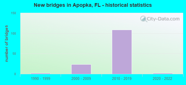
- New bridges - historical statistics
- 21990-1999
- 242000-2009
- 1092010-2019
- 22020-2022


- Bridge Condition - Deck
- 1.4%Excellent
- 69.0%Very good
- 16.9%Good
- 12.7%Satisfactory

- Bridge Condition - Superstructure
- 2.8%Excellent
- 80.3%Very good
- 16.9%Good

- Bridge Condition - Substructure
- 2.8%Excellent
- 87.3%Very good
- 9.9%Good

- Bridge Condition - Channel
- 60.0%Very good
- 40.0%Good
Find on map >> Show street view
Structure Number: 750737, Location: 0.1 Mile South of US-441 (Lat: 28.692014, Lng: -81.558767), Route carried "under" structure: City street , Year Built: 2012, Structure Length: 0. m, Average Daily Traffic: 200 (year 2013), Truck Traffic: 10%, Features Intersected: GE Honey Trans Fiskars, Facility Carried by Structure: SR-429 Viaduct NB
Minimum Vertical Clearance: 7.83m (25.69ft), Kilometerpoint: 0.000, Lanes on structure: 3, Lanes under structure: 2, Material/Design: Prestressed concrete, Design/Construction: Stringer/Multi-beam, Length of Maximum Span: 34.2m (112.2ft)
Find on map >> Show street view
Structure Number: 750738, Location: 0.1 Mile North of G.E. Rd (Lat: 28.694386, Lng: -81.559231), Route carried "under" structure: US 500, Year Built: 2012, Structure Length: 0. m, Average Daily Traffic: 24,500 (year 2011), Truck Traffic: 10%, Features Intersected: US-441 & Fla Cent RR, Facility Carried by Structure: SR-429 SB
Minimum Vertical Clearance: 6.71m (22.01ft), Kilometerpoint: 23.838, Lanes on structure: 4, Lanes under structure: 5, Material/Design: Steel continuous, Design/Construction: Stringer/Multi-beam, Length of Maximum Span: 63.6m (208.7ft)
Find on map >> Show street view
Structure Number: 750739, Location: 0.1 Mile N of G.E. Road (Lat: 28.694336, Lng: -81.558978), Route carried "under" structure: US 441, Year Built: 2012, Structure Length: 0. m, Average Daily Traffic: 23,000 (year 2020), Truck Traffic: 5%, Features Intersected: US-441 & Fla Cent RR, Facility Carried by Structure: SR-429 NB
Minimum Vertical Clearance: 6.71m (22.01ft), Kilometerpoint: 23.789, Lanes on structure: 3, Lanes under structure: 6, Material/Design: Steel continuous, Design/Construction: Stringer/Multi-beam, Length of Maximum Span: 63.6m (208.7ft)
Find on map >> Show street view
Structure Number: 750844, Location: 4.3 Mi N of US-441 (Lat: 28.756519, Lng: -81.567128), Route carried "under" structure: State highway , Year Built: 2017, Structure Length: 0. m, Average Daily Traffic: 9,400 (year 2020), Truck Traffic: 7%, Features Intersected: W Kelly Park Rd, Facility Carried by Structure: SR-429 SB
Minimum Vertical Clearance: 5.55m (18.21ft), Kilometerpoint: 2.564, Lanes on structure: 3, Lanes under structure: 4, Toll: On toll road, Material/Design: Steel, Design/Construction: Box Beam or Girders - Single/Spread, Length of Maximum Span: 49.1m (161.1ft)
Find on map >> Show street view
Structure Number: 750845, Location: 4.3 Mi N of US-441 (Lat: 28.756500, Lng: -81.566861), Route carried "under" structure: City street , Year Built: 2017, Structure Length: 0. m, Average Daily Traffic: 9,400 (year 2020), Truck Traffic: 4%, Features Intersected: W Kelly Park Rd, Facility Carried by Structure: SR-429 NB
Minimum Vertical Clearance: 5.64m (18.50ft), Kilometerpoint: 2.567, Lanes on structure: 3, Lanes under structure: 3, Material/Design: Steel, Design/Construction: Box Beam or Girders - Single/Spread, Length of Maximum Span: 49.1m (161.1ft)
Find on map >> Show street view
Structure Number: 750851, Location: 0.25 Mi. N of US-441 (Lat: 28.698333, Lng: -81.559278), Route carried "under" structure: Ramp Other road , Year Built: 2017, Structure Length: 0. m, Average Daily Traffic: 11,100 (year 2020), Truck Traffic: 6%, Features Intersected: Connector Road, Facility Carried by Structure: SR-429 SB
Minimum Vertical Clearance: 6.71m (22.01ft), Kilometerpoint: 0.407, Lanes on structure: 2, Lanes under structure: 4, Material/Design: Prestressed concrete continuous, Design/Construction: Box Beam or Girders - Single/Spread, Length of Maximum Span: 59.3m (194.6ft)
Find on map >> Show street view
Structure Number: 750852, Location: 0.25 Mi N of US-441 (Lat: 28.698194, Lng: -81.559222), Route carried "under" structure: Ramp Other road , Year Built: 2017, Structure Length: 0. m, Average Daily Traffic: 11,100 (year 2020), Truck Traffic: 6%, Features Intersected: Connector Road, Facility Carried by Structure: SR-429 NB
Minimum Vertical Clearance: 6.98m (22.90ft), Kilometerpoint: 0.426, Lanes on structure: 2, Lanes under structure: 4, Material/Design: Prestressed concrete continuous, Design/Construction: Box Beam or Girders - Single/Spread, Length of Maximum Span: 59.3m (194.6ft)
Find on map >> Show street view
Structure Number: 750853, Location: 0.4 Mile N of US-441 (Lat: 28.700083, Lng: -81.559278), Route carried "under" structure: City street 500, Year Built: 2016, Structure Length: 0. m, Features Intersected: Southfork Drive, Facility Carried by Structure: SR-429 SB
Minimum Vertical Clearance: 7.32m (24.02ft), Kilometerpoint: 0.000, Lanes on structure: 2, Lanes under structure: 2, Material/Design: Prestressed concrete, Design/Construction: Stringer/Multi-beam, Length of Maximum Span: 23.1m (75.8ft)
Find on map >> Show street view
Structure Number: 750854, Location: 0.4 Mile N of US-441 (Lat: 28.700083, Lng: -81.559000), Route carried "under" structure: City street 500, Year Built: 2016, Structure Length: 0. m, Features Intersected: Southfork Drive, Facility Carried by Structure: SR-429 NB
Minimum Vertical Clearance: 7.92m (25.98ft), Kilometerpoint: 0.000, Lanes on structure: 2, Lanes under structure: 2, Material/Design: Prestressed concrete, Design/Construction: Stringer/Multi-beam, Length of Maximum Span: 23.1m (75.8ft)
Find on map >> Show street view
Structure Number: 750855, Location: 0.4 Mile N of US-441 (Lat: 28.700081, Lng: -81.559586), Route carried "under" structure: City street 500, Year Built: 2016, Structure Length: 0. m, Features Intersected: Southfork Drive, Facility Carried by Structure: SR-429 SB Ramp
Minimum Vertical Clearance: 4.75m (15.58ft), Kilometerpoint: 0.000, Lanes on structure: 2, Lanes under structure: 2, Material/Design: Prestressed concrete, Design/Construction: Stringer/Multi-beam, Length of Maximum Span: 23.0m (75.5ft)
Find on map >> Show street view
Structure Number: 750856, Location: 0.4 Mile N of US-441 (Lat: 28.700092, Lng: -81.558797), Route carried "under" structure: City street 500, Year Built: 2016, Structure Length: 0. m, Features Intersected: Southfork Drive, Facility Carried by Structure: SR-429 NB
Minimum Vertical Clearance: 5.12m (16.80ft), Kilometerpoint: 0.000, Lanes on structure: 1, Lanes under structure: 2, Material/Design: Prestressed concrete, Design/Construction: Stringer/Multi-beam, Length of Maximum Span: 28.8m (94.5ft)
Find on map >> Show street view
Structure Number: 750859, Location: 0.92Mi N of US-441 (Lat: 28.708175, Lng: -81.560011), Route carried "under" structure: State highway 429, Year Built: 2016, Structure Length: 0. m, Average Daily Traffic: 27,410 (year 2013), Truck Traffic: 11%, Features Intersected: SR-429, Facility Carried by Structure: Belgian Street
Minimum Vertical Clearance: 5.30m (17.39ft), Kilometerpoint: 0.000, Lanes on structure: 2, Lanes under structure: 4, Toll: On toll road, Material/Design: Prestressed concrete, Design/Construction: Stringer/Multi-beam, Length of Maximum Span: 30.4m (99.7ft)
Find on map >> Show street view
Structure Number: 750861, Location: 2.7 Miles N/O US-441 (Lat: 28.727472, Lng: -81.563500), Route carried "under" structure: County highway , Year Built: 2016, Structure Length: 0. m, Average Daily Traffic: 5,800 (year 2020), Truck Traffic: 7%, Features Intersected: Ponkan Road, Facility Carried by Structure: SR-429 SB
Minimum Vertical Clearance: 5.64m (18.50ft), Kilometerpoint: 0.000, Lanes on structure: 2, Lanes under structure: 2, Material/Design: Prestressed concrete, Design/Construction: Box Beam or Girders - Single/Spread, Length of Maximum Span: 43.6m (143.0ft)
Find on map >> Show street view
Structure Number: 750862, Location: 2.7 Miles N/O US-441 (Lat: 28.727472, Lng: -81.563111), Route carried "under" structure: County highway , Year Built: 2016, Structure Length: 0. m, Average Daily Traffic: 5,800 (year 2020), Truck Traffic: 7%, Features Intersected: Ponkan Road, Facility Carried by Structure: SR-429 NB
Minimum Vertical Clearance: 5.61m (18.41ft), Kilometerpoint: 0.000, Lanes on structure: 2, Lanes under structure: 2, Material/Design: Prestressed concrete, Design/Construction: Box Beam or Girders - Single/Spread, Length of Maximum Span: 43.6m (143.0ft)
Find on map >> Show street view
Structure Number: 750863, Location: 5.2Mi South of SR-46 (Lat: 28.771853, Lng: -81.564203), Route carried "under" structure: ServiceCity street , Year Built: 2018, Structure Length: 0. m, Average Daily Traffic: 300 (year 2020), Truck Traffic: 28%, Features Intersected: Ondich Road & Ramp M, Facility Carried by Structure: SR-429 SB
Minimum Vertical Clearance: 6.80m (22.31ft), Kilometerpoint: 3.058, Lanes on structure: 2, Lanes under structure: 2, Material/Design: Prestressed concrete, Design/Construction: Box Beam or Girders - Single/Spread, Length of Maximum Span: 41.9m (137.5ft)
Find on map >> Show street view
Structure Number: 750863, Location: 5.2Mi South of SR-46 (Lat: 28.771853, Lng: -81.564203), Route carried "under" structure: Ramp Other road , Year Built: 2018, Structure Length: 0. m, Average Daily Traffic: 1,600 (year 2019), Truck Traffic: 4%, Features Intersected: Ondich Road & Ramp M, Facility Carried by Structure: SR-429 SB
Minimum Vertical Clearance: 6.04m (19.82ft), Kilometerpoint: 0.000, Lanes on structure: 2, Lanes under structure: 2, Material/Design: Prestressed concrete, Design/Construction: Box Beam or Girders - Single/Spread, Length of Maximum Span: 41.9m (137.5ft)
Find on map >> Show street view
Structure Number: 750864, Location: 1Mi N of W. Kelly Park Rd (Lat: 28.771417, Lng: -81.563417), Route carried "under" structure: ServiceCity street , Year Built: 2018, Structure Length: 0. m, Average Daily Traffic: 300 (year 2020), Truck Traffic: 28%, Features Intersected: Ondich Road & Ramp M, Facility Carried by Structure: SR-429 NB
Minimum Vertical Clearance: 6.43m (21.10ft), Kilometerpoint: 3.095, Lanes on structure: 2, Lanes under structure: 2, Material/Design: Prestressed concrete, Design/Construction: Box Beam or Girders - Single/Spread, Length of Maximum Span: 41.9m (137.5ft)
Find on map >> Show street view
Structure Number: 750864, Location: 1Mi N of W. Kelly Park Rd (Lat: 28.771417, Lng: -81.563417), Route carried "under" structure: Ramp Other road , Year Built: 2018, Structure Length: 0. m, Average Daily Traffic: 1,600 (year 2019), Truck Traffic: 4%, Features Intersected: Ondich Road & Ramp M, Facility Carried by Structure: SR-429 NB
Minimum Vertical Clearance: 5.88m (19.29ft), Kilometerpoint: 0.000, Lanes on structure: 2, Lanes under structure: 2, Material/Design: Prestressed concrete, Design/Construction: Box Beam or Girders - Single/Spread, Length of Maximum Span: 41.9m (137.5ft)
Find on map >> Show street view
Structure Number: 750865, Location: 1.3Mi N of Kelly Park Rd (Lat: 28.774139, Lng: -81.559861), Route carried "under" structure: City street , Year Built: 2018, Structure Length: 0. m, Average Daily Traffic: 8,800 (year 2020), Truck Traffic: 7%, Features Intersected: Plymouth Sorrento Road, Facility Carried by Structure: SR-429 SB
Minimum Vertical Clearance: 6.42m (21.06ft), Kilometerpoint: 0.000, Lanes on structure: 2, Lanes under structure: 2, Material/Design: Prestressed concrete, Design/Construction: Box Beam or Girders - Single/Spread, Length of Maximum Span: 43.0m (141.1ft)
Find on map >> Show street view
Structure Number: 750866, Location: 1.3Mi N of Kelly Park Rd (Lat: 28.773861, Lng: -81.559889), Route carried "under" structure: City street , Year Built: 2018, Structure Length: 0. m, Average Daily Traffic: 8,800 (year 2020), Truck Traffic: 7%, Features Intersected: Plymouth Sorrento Road, Facility Carried by Structure: SR-429 NB
Minimum Vertical Clearance: 5.65m (18.54ft), Kilometerpoint: 0.000, Lanes on structure: 2, Lanes under structure: 2, Material/Design: Prestressed concrete, Design/Construction: Box Beam or Girders - Single/Spread, Length of Maximum Span: 43.0m (141.1ft)
Find on map >> Show street view
Structure Number: 750867, Location: 2.6 Mi. South of SR-46 (Lat: 28.771333, Lng: -81.565333), Route carried "under" structure: City street , Year Built: 2018, Structure Length: 0. m, Average Daily Traffic: 300 (year 2020), Truck Traffic: 28%, Features Intersected: Ondich Rd., Facility Carried by Structure: SR-453 SB
Minimum Vertical Clearance: 5.46m (17.91ft), Kilometerpoint: 2.918, Lanes on structure: 2, Lanes under structure: 2, Material/Design: Prestressed concrete, Design/Construction: Box Beam or Girders - Single/Spread, Length of Maximum Span: 22.3m (73.2ft)
Find on map >> Show street view
Structure Number: 750868, Location: 5.4 Mi. North of US-441 (Lat: 28.771083, Lng: -81.563194), Route carried "under" structure: State highway 429, Year Built: 2018, Structure Length: 0. m, Average Daily Traffic: 2,650 (year 2020), Truck Traffic: 6%, Features Intersected: SR-429 NB & SB
Minimum Vertical Clearance: 6.13m (20.11ft), Kilometerpoint: 8.304, Lanes on structure: 2, Lanes under structure: 2, Toll: On toll road, Material/Design: Prestressed concrete continuous, Design/Construction: Box Beam or Girders - Single/Spread, Length of Maximum Span: 45.7m (149.9ft)
Find on map >> Show street view
Structure Number: 750869, Location: 4.85Mi S of SR-46 (Lat: 28.774417, Lng: -81.559889), Route carried "under" structure: City street , Year Built: 2018, Structure Length: 0. m, Average Daily Traffic: 8,800 (year 2020), Truck Traffic: 7%, Features Intersected: Plymouth Sorrento Road, Facility Carried by Structure: SR-429 SB
Minimum Vertical Clearance: 5.55m (18.21ft), Kilometerpoint: 9.028, Lanes on structure: 2, Lanes under structure: 2, Material/Design: Prestressed concrete, Design/Construction: Box Beam or Girders - Single/Spread, Length of Maximum Span: 40.1m (131.6ft)
Find on map >> Show street view
Structure Number: 75087, Location: 4.85Mi S of SR-46 (Lat: 28.772889, Lng: -81.559844), Route carried "under" structure: City street , Year Built: 2018, Structure Length: 0. m, Average Daily Traffic: 8,800 (year 2020), Truck Traffic: 7%, Features Intersected: Plymouth Sorrento Road, Facility Carried by Structure: SR-453 SB
Minimum Vertical Clearance: 5.50m (18.04ft), Kilometerpoint: 8.858, Lanes on structure: 2, Lanes under structure: 2, Material/Design: Prestressed concrete, Design/Construction: Box Beam or Girders - Single/Spread, Length of Maximum Span: 45.4m (149.0ft)
Find on map >> Show street view
Structure Number: 750871, Location: 4 Mi. South of SR-46 (Lat: 28.775889, Lng: -81.544750), Route carried "under" structure: ServiceCity street , Year Built: 2018, Structure Length: 0. m, Average Daily Traffic: 10 (year 2018), Truck Traffic: 1%, Features Intersected: Morris Access Road, Facility Carried by Structure: SR-429 SB
Minimum Vertical Clearance: 5.43m (17.81ft), Kilometerpoint: 0.000, Lanes on structure: 2, Lanes under structure: 2, Material/Design: Prestressed concrete, Design/Construction: Box Beam or Girders - Single/Spread, Length of Maximum Span: 28.1m (92.2ft)
Find on map >> Show street view
Structure Number: 750872, Location: 2.3 Mi. N of W Kelley Pk (Lat: 28.775639, Lng: -81.544722), Route carried "under" structure: ServiceCity street , Year Built: 2018, Structure Length: 0. m, Average Daily Traffic: 10 (year 2018), Truck Traffic: 1%, Features Intersected: Morris Access Road, Facility Carried by Structure: SR-429 NB
Minimum Vertical Clearance: 6.28m (20.60ft), Kilometerpoint: 0.000, Lanes on structure: 2, Lanes under structure: 2, Material/Design: Prestressed concrete, Design/Construction: Box Beam or Girders - Single/Spread, Length of Maximum Span: 28.1m (92.2ft)
Find on map >> Show street view
Structure Number: 750877, Location: 2.8Mi South of SR-46 (Lat: 28.777889, Lng: -81.526667), Route carried "under" structure: City street 435, Year Built: 2018, Structure Length: 0. m, Average Daily Traffic: 16,000 (year 2020), Truck Traffic: 6%, Features Intersected: CR-435 Mt. Plymouth Rd., Facility Carried by Structure: SR-429 SB
Minimum Vertical Clearance: 5.94m (19.49ft), Kilometerpoint: 12.604, Lanes on structure: 2, Lanes under structure: 2, Material/Design: Prestressed concrete, Design/Construction: Box Beam or Girders - Single/Spread, Length of Maximum Span: 41.9m (137.5ft)
Find on map >> Show street view
Structure Number: 750878, Location: 2.8Mi S of SR-46 (Lat: 28.777472, Lng: -81.526472), Route carried "under" structure: City street 435, Year Built: 2018, Structure Length: 0. m, Average Daily Traffic: 16,000 (year 2020), Truck Traffic: 6%, Features Intersected: CR-435, Facility Carried by Structure: SR-429 NB
Minimum Vertical Clearance: 6.49m (21.29ft), Kilometerpoint: 12.538, Lanes on structure: 2, Lanes under structure: 2, Material/Design: Prestressed concrete, Design/Construction: Box Beam or Girders - Single/Spread, Length of Maximum Span: 43.0m (141.1ft)
Find on map >> Show street view
Structure Number: 750925, Location: 1.4Mi. South of SR-46 (Lat: 28.786000, Lng: -81.573417), Route carried "under" structure: Other road , Year Built: 2018, Structure Length: 0. m, Average Daily Traffic: 700 (year 2020), Truck Traffic: 80%, Features Intersected: Orange-Lake Co Line, Facility Carried by Structure: SR-453 SB
Minimum Vertical Clearance: 6.04m (19.82ft), Kilometerpoint: 0.000, Lanes on structure: 3, Lanes under structure: 2, Material/Design: Steel, Design/Construction: Box Beam or Girders - Single/Spread, Length of Maximum Span: 50.5m (165.7ft)
Find on map >> Show street view
Structure Number: 750926, Location: 1.4 Mi. South of SR-46 (Lat: 28.786000, Lng: -81.572917), Route carried "under" structure: Other road , Year Built: 2018, Structure Length: 0. m, Average Daily Traffic: 700 (year 2020), Truck Traffic: 80%, Features Intersected: Orange-Lake Co Line, Facility Carried by Structure: SR-453 NB
Minimum Vertical Clearance: 6.00m (19.69ft), Kilometerpoint: 0.000, Lanes on structure: 3, Lanes under structure: 2, Material/Design: Steel, Design/Construction: Box Beam or Girders - Single/Spread, Length of Maximum Span: 50.5m (165.7ft)
Find on map >> Show street view
Structure Number: 754149, Location: 1.5 miles West of SR-436 (Lat: 28.673111, Lng: -81.507306), Route carried "under" structure: State highway 441, Year Built: 2006, Structure Length: 0. m, Average Daily Traffic: 42,500 (year 2021), Truck Traffic: 4%, Features Intersected: US-441, Facility Carried by Structure: West Orange Trail
Minimum Vertical Clearance: 5.43m (17.81ft), Kilometerpoint: 18.123, Lanes under structure: 5, Material/Design: Steel, Design/Construction: Arch - Thru, Length of Maximum Span: 31.7m (104.0ft)
Find on map >> Show street view
Structure Number: 754149, Location: 1.5 miles West of SR-436 (Lat: 28.673111, Lng: -81.507306), Route carried "under" structure: Business Other road , Year Built: 2006, Structure Length: 0. m, Average Daily Traffic: 20 (year 2009), Truck Traffic: 1%, Features Intersected: US-441, Facility Carried by Structure: West Orange Trail
Minimum Vertical Clearance: 3.69m (12.11ft), Kilometerpoint: 0.000, Lanes under structure: 2, Material/Design: Steel, Design/Construction: Arch - Thru, Length of Maximum Span: 31.7m (104.0ft)
Find on map >> Show street view
Structure Number: 754149, Location: 1.5 miles West of SR-436 (Lat: 28.673111, Lng: -81.507306), Route carried "under" structure: Business Other road , Year Built: 2006, Structure Length: 0. m, Average Daily Traffic: 25 (year 2009), Truck Traffic: 1%, Features Intersected: US-441, Facility Carried by Structure: West Orange Trail
Minimum Vertical Clearance: 4.72m (15.49ft), Kilometerpoint: 0.000, Lanes under structure: 2, Material/Design: Steel, Design/Construction: Arch - Thru, Length of Maximum Span: 31.7m (104.0ft)
Find on map >> Show street view
Structure Number: 770123, Location: I-4 WBCD Ramp O1-SR 429 (Lat: 28.796111, Lng: -81.346389), Route carried "under" structure: State highway 417, Year Built: 2021, Structure Length: 0. m, Average Daily Traffic: 5,600 (year 2021), Truck Traffic: 8%, Features Intersected: SR 429, Facility Carried by Structure: I-4 WBCD Ramp O1
Minimum Vertical Clearance: 6.22m (20.41ft), Kilometerpoint: 0.518, Lanes on structure: 4, Lanes under structure: 6, Toll: Toll bridge, Material/Design: Prestressed concrete, Design/Construction: Stringer/Multi-beam, Length of Maximum Span: 34.1m (111.9ft)