Bridge Statistics for Arvada, Colorado (CO)
Condition, Traffic, Stress, Structural Evaluation, Project Costs
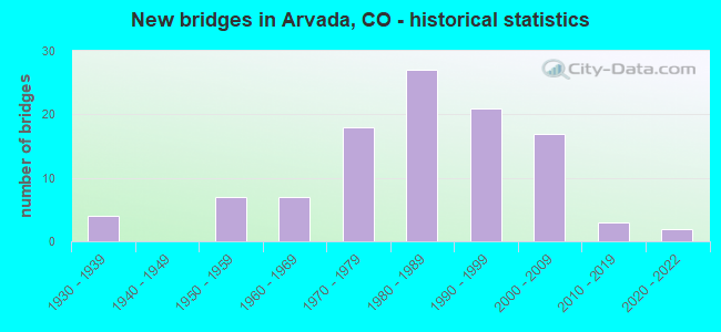
- New bridges - historical statistics
- 41930-1939
- 71950-1959
- 71960-1969
- 181970-1979
- 271980-1989
- 211990-1999
- 172000-2009
- 32010-2019
- 22020-2022
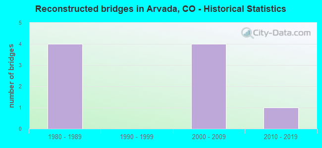
- Reconstructed bridges - Historical Statistics
- 41980-1989
- 01990-1999
- 42000-2009
- 12010-2019
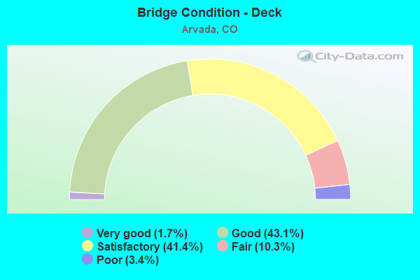
- Bridge Condition - Deck
- 1.7%Very good
- 43.1%Good
- 41.4%Satisfactory
- 10.3%Fair
- 3.4%Poor
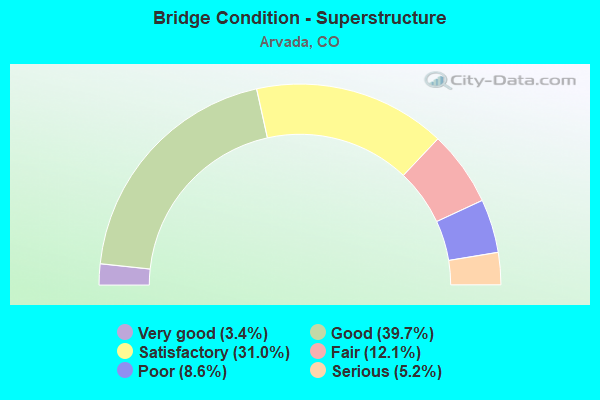
- Bridge Condition - Superstructure
- 3.4%Very good
- 39.7%Good
- 31.0%Satisfactory
- 12.1%Fair
- 8.6%Poor
- 5.2%Serious
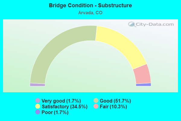
- Bridge Condition - Substructure
- 1.7%Very good
- 51.7%Good
- 34.5%Satisfactory
- 10.3%Fair
- 1.7%Poor
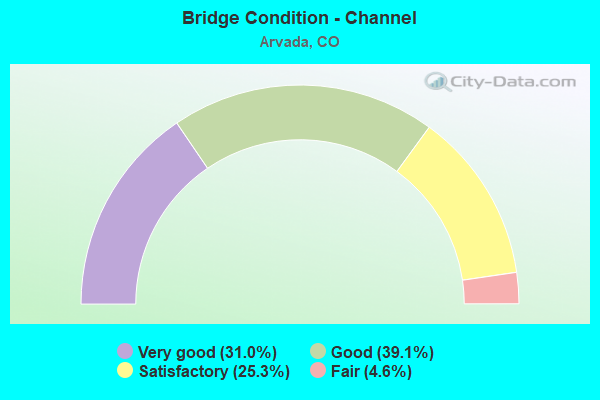
- Bridge Condition - Channel
- 31.0%Very good
- 39.1%Good
- 25.3%Satisfactory
- 4.6%Fair
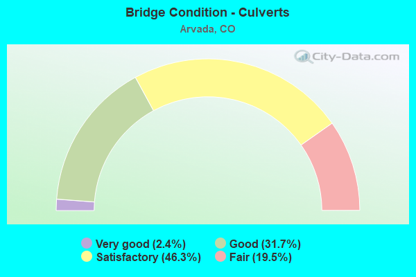
- Bridge Condition - Culverts
- 2.4%Very good
- 31.7%Good
- 46.3%Satisfactory
- 19.5%Fair
Find on map >> Show street view
Structure Number: ARVA-56-0.01-01, Location: 0.01 MI SW OF RALSTON RD (Lat: 39.798336, Lng: -105.056725), Route carried "on" structure: City street , Year Built: 2000, Status: Open, Structure Length: 4.42m (14.50ft), Average Daily Traffic: 4,301 (year 2021), Truck Traffic: 9%, Average Future Daily Traffic: 4,946 (year 2041), Design Load: HS 25 or greater, Features Intersected: RALSTON CREEK, Facility Carried by Structure: 56TH AVENUE
Minimum Vertical Clearance: 30.45m (99.90ft), Kilometerpoint: 1.601, Lanes on structure: 2, Owner: City or Municipal Highway Agency, Approaching Roadway Width: 12.0m (39.4ft), Skew: 1 degrees, Material/Design: Concrete continuous, Design/Construction: Slab, Number Of Spans In Main Unit: 3, Length of Maximum Span: 16.7m (54.8ft), Curb or Sidewalk Widths: Left: 2.4m (7.9ft), Right: 2.4m (7.9ft), Curb-To-Curb Width: 13.4m (44.0ft), Out-to-Out Width: 19.7m (64.6ft)
Condition: Deck: Good, Superstructure: Good, Substructure: Good, Channel: Fair, Operating Rating: 92.5 metric tons, Method Used To Determine Operating Rating: Load Factor (LF), Inventory Rating: 55.5 metric tons, Method Used To Determine Inventory Rating: Load Factor (LF), Structural Evaluation: Better than present minimum criteria, Deck Geometry: Better than present minimum criteria, Waterway Adequacy: Equal to present minimum criteria, Approach Roadway Alignment: Equal to present desirable criteria, Designated Inspection Frequency: Every 24 months, Inspection Date: March 2021, Deck Structure Type: Concrete Cast-file-Place, Wearing Surface/Protective System: Wearing Surface: Bituminous, Membrane: Built-up, Deck Protection: Epoxy Coated Reinforcing
Find on map >> Show street view
Structure Number: ARVA-58-2.60-01, Location: AT INTERSECTION OF NELSON (Lat: 39.801647, Lng: -105.118358), Route carried "on" structure: City street , Year Built: 1979, Status: Open, Structure Length: 1.13m (3.71ft), Average Daily Traffic: 14,687 (year 2021), Truck Traffic: 5%, Average Future Daily Traffic: 16,890 (year 2041), Design Load: HS 20, Features Intersected: VAN BIBBER CREEK, Facility Carried by Structure: 58TH AVENUE
Minimum Vertical Clearance: 30+ m (98+ ft), Kilometerpoint: 1.690, Lanes on structure: 5, Owner: City or Municipal Highway Agency, Approaching Roadway Width: 15.2m (49.9ft), Skew: 25 degrees, Material/Design: Concrete, Design/Construction: Culvert, Number Of Spans In Main Unit: 3, Length of Maximum Span: 3.3m (10.8ft), Curb or Sidewalk Widths: Left: 2.1m (6.9ft), Right: 0.0m, Curb-To-Curb Width: 20.3m (66.6ft), Out-to-Out Width: 51.5m (169.0ft)
Condition: Channel: Good, Culverts: Satisfactory, Operating Rating: 81.6 metric tons, Method Used To Determine Operating Rating: Load Factor (LF), Inventory Rating: 55.1 metric tons, Method Used To Determine Inventory Rating: Load Factor (LF), Structural Evaluation: Equal to present minimum criteria, Deck Geometry: Somewhat better than minimum adequacy, Waterway Adequacy: Equal to present minimum criteria, Approach Roadway Alignment: Equal to present desirable criteria, Designated Inspection Frequency: Every 24 months, Inspection Date: April 2021
Find on map >> Show street view
Structure Number: ARVA-58-2.80-02, Location: JUST WEST OF KIPLING PKWY (Lat: 39.801731, Lng: -105.112683), Route carried "on" structure: City street , Year Built: 1979, Status: Open, Structure Length: 1.04m (3.41ft), Average Daily Traffic: 14,429 (year 2021), Truck Traffic: 6%, Average Future Daily Traffic: 16,593 (year 2041), Features Intersected: VAN BIBBER CREEK, Facility Carried by Structure: 58TH AVENUE
Minimum Vertical Clearance: 30+ m (98+ ft), Kilometerpoint: 2.171, Lanes on structure: 4, Owner: City or Municipal Highway Agency, Approaching Roadway Width: 15.4m (50.5ft), Skew: 34 degrees, Material/Design: Concrete, Design/Construction: Culvert, Number Of Spans In Main Unit: 3, Length of Maximum Span: 3.0m (9.8ft), Curb or Sidewalk Widths: Left: 2.1m (6.9ft), Right: 0.0m, Curb-To-Curb Width: 15.4m (50.5ft), Out-to-Out Width: 26.4m (86.6ft)
Condition: Channel: Good, Culverts: Fair, Operating Rating: 81.6 metric tons, Method Used To Determine Operating Rating: Load Factor (LF), Inventory Rating: 55.2 metric tons, Method Used To Determine Inventory Rating: Load Factor (LF), Structural Evaluation: Somewhat better than minimum adequacy, Deck Geometry: Meets minimum limits, Waterway Adequacy: Equal to present minimum criteria, Approach Roadway Alignment: Equal to present desirable criteria, Designated Inspection Frequency: Every 24 months, Inspection Date: April 2021
Find on map >> Show street view
Structure Number: ARVA-58-5.30-3A, Location: JUST E OF LAMAR STREET (Lat: 39.801853, Lng: -105.067100), Route carried "on" structure: City street , Year Built: 1996, Status: Open, Structure Length: 7.20m (23.62ft), Average Daily Traffic: 10,681 (year 2021), Truck Traffic: 4%, Average Future Daily Traffic: 12,283 (year 2041), Design Load: HS 20, Features Intersected: RALSTON CREEK, Facility Carried by Structure: 58TH AVENUE
Minimum Vertical Clearance: 30+ m (98+ ft), Kilometerpoint: 3.281, Lanes on structure: 6, Owner: City or Municipal Highway Agency, Approaching Roadway Width: 23.2m (76.1ft), Skew: 26 degrees, Material/Design: Concrete continuous, Design/Construction: Slab, Number Of Spans In Main Unit: 3, Length of Maximum Span: 25.6m (84.0ft), Curb or Sidewalk Widths: Left: 2.1m (6.9ft), Right: 0.0m, Curb-To-Curb Width: 23.2m (76.1ft), Out-to-Out Width: 26.1m (85.6ft)
Condition: Deck: Good, Superstructure: Good, Substructure: Good, Channel: Very good, Operating Rating: 81.6 metric tons, Method Used To Determine Operating Rating: Load Factor (LF), Inventory Rating: 74.9 metric tons, Method Used To Determine Inventory Rating: Load Factor (LF), Structural Evaluation: Better than present minimum criteria, Deck Geometry: Meets minimum limits, Waterway Adequacy: Equal to present desirable criteria, Approach Roadway Alignment: Equal to present desirable criteria, Designated Inspection Frequency: Every 24 months, Inspection Date: April 2021, Deck Structure Type: Concrete Cast-file-Place, Wearing Surface/Protective System: Wearing Surface: Bituminous, Membrane: Built-up, Deck Protection: Epoxy Coated Reinforcing
Find on map >> Show street view
Structure Number: ARVA-58-ID.01, Location: NW OF 58TH AND INDEPEND (Lat: 39.801733, Lng: -105.106608), Route carried "on" structure: City street , Year Built: 2006, Status: Open, Structure Length: 1.06m (3.48ft), Average Daily Traffic: 21,216 (year 2021), Truck Traffic: 2%, Average Future Daily Traffic: 24,398 (year 2041), Design Load: HS 20, Features Intersected: VAN BIBBER CREEK, Facility Carried by Structure: 58TH AVE AND IND
Minimum Vertical Clearance: 30.45m (99.90ft), Kilometerpoint: 2.680, Lanes on structure: 9, Owner: City or Municipal Highway Agency, Approaching Roadway Width: 21.9m (71.9ft), Skew: 39 degrees, Material/Design: Concrete, Design/Construction: Culvert, Number Of Spans In Main Unit: 2, Length of Maximum Span: 5.1m (16.7ft), Curb or Sidewalk Widths: Left: 1.7m (5.6ft), Right: 0.0m, Out-to-Out Width: 219.8m (721.1ft)
Condition: Channel: Very good, Culverts: Satisfactory, Structural Evaluation: Equal to present minimum criteria, Waterway Adequacy: Equal to present desirable criteria, Approach Roadway Alignment: Equal to present desirable criteria, Designated Inspection Frequency: Every 24 months, Inspection Date: March 2021
Find on map >> Show street view
Structure Number: ARVA-61-0.17-01, Location: .17 MI E OF RALSTON ROAD (Lat: 39.807983, Lng: -105.106400), Route carried "on" structure: City street , Year Built: 1957, Status: Open, Structure Length: 0.85m (2.79ft), Average Daily Traffic: 184 (year 2021), Truck Traffic: 2%, Average Future Daily Traffic: 212 (year 2041), Features Intersected: RALSTON CREEK, Facility Carried by Structure: 61ST AVENUE
Minimum Vertical Clearance: 30+ m (98+ ft), Kilometerpoint: 0.124, Lanes on structure: 2, Owner: City or Municipal Highway Agency, Approaching Roadway Width: 10.4m (34.1ft), Material/Design: Concrete, Design/Construction: Culvert, Number Of Spans In Main Unit: 2, Length of Maximum Span: 4.1m (13.5ft), Curb or Sidewalk Widths: Left: 1.2m (3.9ft), Right: 1.1m (3.6ft), Curb-To-Curb Width: 10.4m (34.1ft), Out-to-Out Width: 13.5m (44.3ft)
Condition: Channel: Very good, Culverts: Fair, Operating Rating: 36.3 metric tons, Method Used To Determine Operating Rating: Field evaluation and documented engineering judgment, Inventory Rating: 32.7 metric tons, Method Used To Determine Inventory Rating: Field evaluation and documented engineering judgment, Structural Evaluation: Somewhat better than minimum adequacy, Deck Geometry: Better than present minimum criteria, Waterway Adequacy: Better than present minimum criteria, Approach Roadway Alignment: Equal to present desirable criteria, Designated Inspection Frequency: Every 24 months, Inspection Date: April 2021
Find on map >> Show street view
Structure Number: ARVA-63-1.1-05, Location: JUST SE OF INDIANA/64TH (Lat: 39.811747, Lng: -105.164281), Route carried "on" structure: City street , Year Built: 1981, Status: Open, Structure Length: 1.19m (3.90ft), Average Daily Traffic: 183 (year 2021), Average Future Daily Traffic: 210 (year 2041), Features Intersected: CROKE CANAL, Facility Carried by Structure: 63RD PLACE
Minimum Vertical Clearance: 30+ m (98+ ft), Kilometerpoint: 0.076, Lanes on structure: 2, Owner: City or Municipal Highway Agency, Approaching Roadway Width: 9.1m (29.9ft), Material/Design: Prestressed concrete, Design/Construction: Tee Beam, Number Of Spans In Main Unit: 1, Length of Maximum Span: 10.8m (35.4ft), Curb or Sidewalk Widths: Left: 1.2m (3.9ft), Right: 1.2m (3.9ft), Curb-To-Curb Width: 10.4m (34.1ft), Out-to-Out Width: 12.8m (42.0ft)
Condition: Deck: Satisfactory, Superstructure: Satisfactory, Substructure: Satisfactory, Channel: Good, Operating Rating: 36.3 metric tons, Method Used To Determine Operating Rating: Field evaluation and documented engineering judgment, Inventory Rating: 32.7 metric tons, Method Used To Determine Inventory Rating: Field evaluation and documented engineering judgment, Structural Evaluation: Equal to present minimum criteria, Deck Geometry: Better than present minimum criteria, Waterway Adequacy: Better than present minimum criteria, Approach Roadway Alignment: Equal to present desirable criteria, Designated Inspection Frequency: Every 24 months, Inspection Date: March 2021, Deck Structure Type: Concrete Cast-file-Place, Wearing Surface/Protective System: Wearing Surface: Bituminous
Find on map >> Show street view
Structure Number: ARVA-64-0.28-01, Location: 0.28 MI W OF INDIANA ST (Lat: 39.812378, Lng: -105.169431), Route carried "on" structure: City street , Year Built: 1998, Status: Open, Structure Length: 0.64m (2.10ft), Average Daily Traffic: 24,068 (year 2021), Truck Traffic: 4%, Average Future Daily Traffic: 27,678 (year 2041), Design Load: HS 25 or greater, Features Intersected: FARMERS HIGHLINE CANAL, Facility Carried by Structure: 64TH AVENUE
Minimum Vertical Clearance: 30+ m (98+ ft), Kilometerpoint: 2.066, Lanes on structure: 8, Owner: City or Municipal Highway Agency, Approaching Roadway Width: 22.4m (73.5ft), Skew: 4 degrees, Material/Design: Concrete, Design/Construction: Culvert, Number Of Spans In Main Unit: 1, Length of Maximum Span: 6.4m (21.0ft), Curb or Sidewalk Widths: Left: 2.2m (7.2ft), Right: 2.4m (7.9ft), Out-to-Out Width: 37.7m (123.7ft)
Condition: Channel: Satisfactory, Culverts: Good, Operating Rating: 36.3 metric tons, Method Used To Determine Operating Rating: Field evaluation and documented engineering judgment, Inventory Rating: 32.7 metric tons, Method Used To Determine Inventory Rating: Field evaluation and documented engineering judgment, Structural Evaluation: Better than present minimum criteria, Waterway Adequacy: Equal to present desirable criteria, Approach Roadway Alignment: Equal to present desirable criteria, Designated Inspection Frequency: Every 24 months, Inspection Date: March 2021
Find on map >> Show street view
Structure Number: ARVA-64-0.30-01, Location: 0.3 MI EAST OF SH 93 (Lat: 39.816078, Lng: -105.213961), Route carried "on" structure: City street , Year Built: 2000, Status: Open, Structure Length: 0.71m (2.33ft), Average Daily Traffic: 6,792 (year 2021), Truck Traffic: 3%, Average Future Daily Traffic: 7,811 (year 2041), Design Load: HS 20, Features Intersected: S BLDR DIVERSION CANAL, Facility Carried by Structure: 64TH PARKWAY
Minimum Vertical Clearance: 30+ m (98+ ft), Kilometerpoint: 0.715, Lanes on structure: 4, Owner: City or Municipal Highway Agency, Approaching Roadway Width: 18.4m (60.4ft), Skew: 35 degrees, Material/Design: Concrete, Design/Construction: Culvert, Number Of Spans In Main Unit: 1, Length of Maximum Span: 7.1m (23.3ft), Curb or Sidewalk Widths: Left: 2.6m (8.5ft), Right: 2.6m (8.5ft), Out-to-Out Width: 43.8m (143.7ft)
Condition: Channel: Very good, Culverts: Satisfactory, Structural Evaluation: Equal to present minimum criteria, Waterway Adequacy: Equal to present desirable criteria, Approach Roadway Alignment: Equal to present desirable criteria, Designated Inspection Frequency: Every 24 months, Inspection Date: March 2021
Find on map >> Show street view
Structure Number: ARVA-64-1.1-01, Location: 1.1 MI EAST OF SH 93 (Lat: 39.813606, Lng: -105.200522), Route carried "on" structure: City street , Year Built: 2000, Status: Open, Structure Length: 0.81m (2.66ft), Average Daily Traffic: 183 (year 2021), Truck Traffic: 3%, Average Future Daily Traffic: 210 (year 2041), Design Load: HS 20, Features Intersected: LOCAL DRAINAGE, Facility Carried by Structure: 64TH AVENUE
Minimum Vertical Clearance: 30+ m (98+ ft), Kilometerpoint: 2.013, Lanes on structure: 4, Owner: City or Municipal Highway Agency, Approaching Roadway Width: 18.2m (59.7ft), Skew: 30 degrees, Material/Design: Concrete, Design/Construction: Frame, Number Of Spans In Main Unit: 1, Length of Maximum Span: 7.3m (24.0ft), Curb or Sidewalk Widths: Left: 2.6m (8.5ft), Right: 2.6m (8.5ft), Curb-To-Curb Width: 18.2m (59.7ft), Out-to-Out Width: 39.3m (128.9ft)
Condition: Deck: Fair, Superstructure: Fair, Substructure: Good, Channel: Good, Structural Evaluation: Somewhat better than minimum adequacy, Deck Geometry: Somewhat better than minimum adequacy, Waterway Adequacy: Equal to present desirable criteria, Approach Roadway Alignment: Equal to present desirable criteria, Designated Inspection Frequency: Every 24 months, Inspection Date: March 2021, Deck Structure Type: Other, Wearing Surface/Protective System: Wearing Surface: Bituminous
Find on map >> Show street view
Structure Number: ARVA-67-0.01-01, Location: JUST E OF WESTWOODS CIR (Lat: 39.819214, Lng: -105.179608), Route carried "on" structure: City street , Year Built: 1993, Status: Open, Structure Length: 0.87m (2.85ft), Average Daily Traffic: 183 (year 2021), Truck Traffic: 2%, Average Future Daily Traffic: 210 (year 2041), Design Load: HS 20, Features Intersected: FARMERS HIGHLINE CANAL, Facility Carried by Structure: 67TH PLACE
Minimum Vertical Clearance: 30+ m (98+ ft), Kilometerpoint: 0.010, Lanes on structure: 2, Owner: City or Municipal Highway Agency, Approaching Roadway Width: 10.4m (34.1ft), Skew: 30 degrees, Material/Design: Concrete, Design/Construction: Frame, Number Of Spans In Main Unit: 1, Length of Maximum Span: 8.3m (27.2ft), Curb or Sidewalk Widths: Left: 1.3m (4.3ft), Right: 1.3m (4.3ft), Curb-To-Curb Width: 10.4m (34.1ft), Out-to-Out Width: 17.0m (55.8ft)
Condition: Deck: Satisfactory, Superstructure: Satisfactory, Substructure: Good, Channel: Good, Operating Rating: 49.2 metric tons, Method Used To Determine Operating Rating: Load Factor (LF), Inventory Rating: 29.5 metric tons, Method Used To Determine Inventory Rating: Load Factor (LF), Structural Evaluation: Equal to present minimum criteria, Deck Geometry: Better than present minimum criteria, Waterway Adequacy: Equal to present desirable criteria, Approach Roadway Alignment: Equal to present desirable criteria, Designated Inspection Frequency: Every 24 months, Inspection Date: March 2021, Deck Structure Type: Other, Wearing Surface/Protective System: Wearing Surface: Bituminous
Find on map >> Show street view
Structure Number: ARVA-68-0.20-02, Location: 0.1 MI W OF 67TH PLACE (Lat: 39.819558, Lng: -105.122303), Route carried "on" structure: City street , Year Built: 1965, Status: Open, Structure Length: 0.66m (2.17ft), Average Daily Traffic: 585 (year 2021), Truck Traffic: 4%, Average Future Daily Traffic: 673 (year 2041), Features Intersected: RALSTON CREEK, Facility Carried by Structure: 68TH AVENUE
Minimum Vertical Clearance: 30+ m (98+ ft), Kilometerpoint: 0.151, Lanes on structure: 2, Owner: City or Municipal Highway Agency, Approaching Roadway Width: 13.6m (44.6ft), Skew: 1 degrees, Material/Design: Concrete, Design/Construction: Culvert, Number Of Spans In Main Unit: 2, Length of Maximum Span: 3.2m (10.5ft), Curb or Sidewalk Widths: Left: 0.9m (3.0ft), Right: 0.9m (3.0ft), Curb-To-Curb Width: 13.6m (44.6ft), Out-to-Out Width: 15.9m (52.2ft)
Condition: Channel: Fair, Culverts: Satisfactory, Operating Rating: 36.3 metric tons, Method Used To Determine Operating Rating: Field evaluation and documented engineering judgment, Inventory Rating: 32.7 metric tons, Method Used To Determine Inventory Rating: Field evaluation and documented engineering judgment, Structural Evaluation: Equal to present minimum criteria, Deck Geometry: Superior to present desirable criteria, Waterway Adequacy: Better than present minimum criteria, Approach Roadway Alignment: Equal to present desirable criteria, Designated Inspection Frequency: Every 24 months, Inspection Date: April 2021
Find on map >> Show street view
Structure Number: ARVA-68-0.30-01, Location: .3 MI SOUTH OF 72ND AVE (Lat: 39.822919, Lng: -105.149400), Route carried "on" structure: City street , Year Built: 1978, Status: Open, Structure Length: 4.86m (15.94ft), Average Daily Traffic: 1,714 (year 2021), Truck Traffic: 2%, Average Future Daily Traffic: 1,971 (year 2041), Design Load: HS 20, Features Intersected: RALSTON CREEK, Facility Carried by Structure: BEECH STREET
Minimum Vertical Clearance: 30+ m (98+ ft), Kilometerpoint: 0.091, Lanes on structure: 2, Owner: City or Municipal Highway Agency, Approaching Roadway Width: 13.5m (44.3ft), Material/Design: Concrete continuous, Design/Construction: Slab, Number Of Spans In Main Unit: 4, Length of Maximum Span: 12.2m (40.0ft), Curb or Sidewalk Widths: Left: 1.4m (4.6ft), Right: 1.4m (4.6ft), Curb-To-Curb Width: 13.5m (44.3ft), Out-to-Out Width: 17.0m (55.8ft)
Condition: Deck: Good, Superstructure: Good, Substructure: Good, Channel: Good, Operating Rating: 45.5 metric tons, Method Used To Determine Operating Rating: Load Factor (LF), Inventory Rating: 27.3 metric tons, Method Used To Determine Inventory Rating: Load Factor (LF), Structural Evaluation: Equal to present minimum criteria, Deck Geometry: Superior to present desirable criteria, Waterway Adequacy: Equal to present desirable criteria, Approach Roadway Alignment: Equal to present desirable criteria, Designated Inspection Frequency: Every 24 months, Inspection Date: March 2021, Deck Structure Type: Concrete Cast-file-Place, Wearing Surface/Protective System: Wearing Surface: Bituminous
Find on map >> Show street view
Structure Number: ARVA-68-0.40-02, Location: .3 MI SOUTH OF 72ND AVE (Lat: 39.823414, Lng: -105.156619), Route carried "on" structure: City street , Year Built: 1985, Status: Open, Structure Length: 2.24m (7.35ft), Average Daily Traffic: 2,152 (year 2021), Truck Traffic: 2%, Average Future Daily Traffic: 2,475 (year 2041), Design Load: HS 20, Features Intersected: RALSTON CREEK, Facility Carried by Structure: ELDRIDGE STREET
Minimum Vertical Clearance: 30+ m (98+ ft), Kilometerpoint: 0.391, Lanes on structure: 2, Owner: City or Municipal Highway Agency, Approaching Roadway Width: 10.8m (35.4ft), Material/Design: Steel, Design/Construction: Stringer/Multi-beam, Number Of Spans In Main Unit: 1, Length of Maximum Span: 21.3m (69.9ft), Curb or Sidewalk Widths: Left: 0.0m, Right: 2.0m (6.6ft), Curb-To-Curb Width: 11.5m (37.7ft), Out-to-Out Width: 14.1m (46.3ft)
Condition: Deck: Satisfactory, Superstructure: Satisfactory, Substructure: Satisfactory, Channel: Good, Operating Rating: 51.0 metric tons, Method Used To Determine Operating Rating: Load Factor (LF), Inventory Rating: 32.7 metric tons, Method Used To Determine Inventory Rating: Load Factor (LF), Structural Evaluation: Equal to present minimum criteria, Deck Geometry: Somewhat better than minimum adequacy, Waterway Adequacy: Equal to present desirable criteria, Approach Roadway Alignment: Equal to present desirable criteria, Designated Inspection Frequency: Every 24 months, Inspection Date: March 2021, Deck Structure Type: Concrete Cast-file-Place, Wearing Surface/Protective System: Wearing Surface: Bituminous, Membrane: Built-up
Find on map >> Show street view
Structure Number: ARVA-70-0.01-01, Location: 0.3 MI E OF QUAKER STREET (Lat: 39.823364, Lng: -105.178714), Route carried "on" structure: City street , Year Built: 1993, Status: Open, Structure Length: 0.66m (2.17ft), Average Daily Traffic: 231 (year 2021), Truck Traffic: 2%, Average Future Daily Traffic: 266 (year 2041), Design Load: HS 20, Features Intersected: FARMERS HIGHLINE CANAL, Facility Carried by Structure: 70TH AVENUE
Minimum Vertical Clearance: 30+ m (98+ ft), Kilometerpoint: 0.801, Lanes on structure: 2, Owner: City or Municipal Highway Agency, Approaching Roadway Width: 10.4m (34.1ft), Skew: 3 degrees, Material/Design: Concrete, Design/Construction: Culvert, Number Of Spans In Main Unit: 1, Length of Maximum Span: 6.6m (21.7ft), Curb or Sidewalk Widths: Left: 1.4m (4.6ft), Right: 1.4m (4.6ft), Curb-To-Curb Width: 13.7m (44.9ft), Out-to-Out Width: 32.8m (107.6ft)
Condition: Channel: Very good, Culverts: Good, Operating Rating: 36.3 metric tons, Method Used To Determine Operating Rating: Field evaluation and documented engineering judgment, Inventory Rating: 32.7 metric tons, Method Used To Determine Inventory Rating: Field evaluation and documented engineering judgment, Structural Evaluation: Better than present minimum criteria, Deck Geometry: Superior to present desirable criteria, Waterway Adequacy: Equal to present desirable criteria, Approach Roadway Alignment: Equal to present desirable criteria, Designated Inspection Frequency: Every 24 months, Inspection Date: March 2021
Find on map >> Show street view
Structure Number: ARVA-72-0.80-01, Location: 0.2 MI W OF SIMMS ST (Lat: 39.827047, Lng: -105.132183), Route carried "on" structure: City street , Year Built: 1970, Status: Open, Structure Length: 1.25m (4.10ft), Average Daily Traffic: 14,073 (year 2021), Truck Traffic: 5%, Average Future Daily Traffic: 16,184 (year 2041), Features Intersected: LEYDEN CREEK, Facility Carried by Structure: 72ND AVENUE
Minimum Vertical Clearance: 30+ m (98+ ft), Kilometerpoint: 0.732, Lanes on structure: 2, Owner: City or Municipal Highway Agency, Approaching Roadway Width: 7.3m (24.0ft), Skew: 3 degrees, Material/Design: Prestressed concrete, Design/Construction: Tee Beam, Number Of Spans In Main Unit: 1, Length of Maximum Span: 11.8m (38.7ft), Curb-To-Curb Width: 10.9m (35.8ft), Out-to-Out Width: 12.2m (40.0ft)
Condition: Deck: Satisfactory, Superstructure: Satisfactory, Substructure: Satisfactory, Channel: Good, Operating Rating: 36.3 metric tons, Method Used To Determine Operating Rating: Field evaluation and documented engineering judgment, Inventory Rating: 32.7 metric tons, Method Used To Determine Inventory Rating: Field evaluation and documented engineering judgment, Structural Evaluation: Equal to present minimum criteria, Deck Geometry: Meets minimum limits, Waterway Adequacy: Equal to present desirable criteria, Approach Roadway Alignment: Equal to present desirable criteria, Designated Inspection Frequency: Every 24 months, Inspection Date: March 2021, Deck Structure Type: Concrete Cast-file-Place, Wearing Surface/Protective System: Wearing Surface: Bituminous
Find on map >> Show street view
Structure Number: ARVA-72-1.60-01, Location: 0.2 MI WEST OF CARR ST (Lat: 39.826803, Lng: -105.096286), Route carried "on" structure: City street , Year Built: 2004, Status: Open, Structure Length: 0.66m (2.17ft), Average Daily Traffic: 13,101 (year 2021), Truck Traffic: 3%, Average Future Daily Traffic: 15,066 (year 2041), Design Load: HS 25 or greater, Features Intersected: PEDESTRIAN PATH, Facility Carried by Structure: 72ND AVENUE
Minimum Vertical Clearance: 30+ m (98+ ft), Kilometerpoint: 3.801, Lanes on structure: 5, Owner: City or Municipal Highway Agency, Approaching Roadway Width: 18.3m (60.0ft), Skew: 32 degrees, Material/Design: Concrete, Design/Construction: Culvert, Number Of Spans In Main Unit: 1, Length of Maximum Span: 6.6m (21.7ft), Curb or Sidewalk Widths: Left: 0.0m, Right: 2.5m (8.2ft), Curb-To-Curb Width: 21.7m (71.2ft), Out-to-Out Width: 27.2m (89.2ft)
Condition: Culverts: Good, Inventory Rating: 68.9 metric tons, Method Used To Determine Inventory Rating: Load Factor (LF), Structural Evaluation: Better than present minimum criteria, Deck Geometry: Somewhat better than minimum adequacy, Approach Roadway Alignment: Equal to present desirable criteria, Designated Inspection Frequency: Every 24 months, Inspection Date: March 2021
Find on map >> Show street view
Structure Number: ARVA-74-0.90-01, Location: .1 MI W OF CARR STREET (Lat: 39.830772, Lng: -105.092525), Route carried "on" structure: City street , Year Built: 1955, Status: Open, Structure Length: 1.07m (3.51ft), Average Daily Traffic: 3,181 (year 2021), Truck Traffic: 2%, Average Future Daily Traffic: 3,658 (year 2041), Features Intersected: CROKE CANAL, Facility Carried by Structure: 74TH AVENUE
Minimum Vertical Clearance: 30+ m (98+ ft), Kilometerpoint: 1.519, Lanes on structure: 2, Owner: City or Municipal Highway Agency, Approaching Roadway Width: 7.5m (24.6ft), Skew: 3 degrees, Material/Design: Steel, Design/Construction: Stringer/Multi-beam, Number Of Spans In Main Unit: 1, Length of Maximum Span: 8.9m (29.2ft), Curb-To-Curb Width: 7.6m (24.9ft), Out-to-Out Width: 9.4m (30.8ft)
Condition: Deck: Fair, Superstructure: Fair, Substructure: Satisfactory, Channel: Very good, Operating Rating: 29.9 metric tons, Method Used To Determine Operating Rating: Load Factor (LF), Inventory Rating: 17.9 metric tons, Method Used To Determine Inventory Rating: Load Factor (LF), Structural Evaluation: Meets minimum limits, Deck Geometry: High priority of replacement, Waterway Adequacy: Equal to present desirable criteria, Approach Roadway Alignment: Equal to present minimum criteria, Length Of Structure Improvement: 1.07m (3.51ft), Designated Inspection Frequency: Every 24 months, Inspection Date: March 2021, Bridge Improvement Cost: $184,000, Roadway Improvement Cost: $18,000, Total Project Cost: $202,000 ( Estimate for 2015), Deck Structure Type: Concrete Cast-file-Place, Wearing Surface/Protective System: Wearing Surface: Bituminous
Find on map >> Show street view
Structure Number: ARVA-74-0.90-02, Location: 0.15 MI WEST OF CARR ST (Lat: 39.830775, Lng: -105.093406), Route carried "on" structure: City street , Year Built: 1930, Status: Open, Structure Length: 0.72m (2.36ft), Average Daily Traffic: 3,182 (year 2021), Truck Traffic: 2%, Average Future Daily Traffic: 3,659 (year 2041), Features Intersected: FARMERS HIGHLINE CANAL, Facility Carried by Structure: 74TH AVENUE
Minimum Vertical Clearance: 30+ m (98+ ft), Kilometerpoint: 1.437, Lanes on structure: 2, Owner: City or Municipal Highway Agency, Approaching Roadway Width: 7.0m (23.0ft), Material/Design: Steel, Design/Construction: Stringer/Multi-beam, Number Of Spans In Main Unit: 1, Length of Maximum Span: 6.1m (20.0ft), Curb-To-Curb Width: 7.2m (23.6ft), Out-to-Out Width: 9.3m (30.5ft)
Condition: Deck: Fair, Superstructure: Satisfactory, Substructure: Satisfactory, Channel: Good, Operating Rating: 36.3 metric tons, Method Used To Determine Operating Rating: Load Factor (LF), Inventory Rating: 32.7 metric tons, Method Used To Determine Inventory Rating: Load Factor (LF), Structural Evaluation: Equal to present minimum criteria, Deck Geometry: High priority of replacement, Waterway Adequacy: Equal to present desirable criteria, Approach Roadway Alignment: Equal to present minimum criteria, Length Of Structure Improvement: 0.72m (2.36ft), Designated Inspection Frequency: Every 24 months, Inspection Date: March 2021, Bridge Improvement Cost: $126,000, Roadway Improvement Cost: $13,000, Total Project Cost: $139,000 ( Estimate for 2015), Deck Structure Type: Concrete Cast-file-Place, Wearing Surface/Protective System: Wearing Surface: Bituminous
Find on map >> Show street view
Structure Number: ARVA-80-0.15-01, Location: .15 MI E OF KIPLING ST (Lat: 39.841817, Lng: -105.108225), Route carried "on" structure: City street , Year Built: 1930, Year Reconstructed: 1980, Status: Open, Structure Length: 0.73m (2.40ft), Average Daily Traffic: 16,690 (year 2021), Truck Traffic: 6%, Average Future Daily Traffic: 19,194 (year 2041), Features Intersected: FARMERS HIGHLINE CANAL, Facility Carried by Structure: 80TH AVENUE
Minimum Vertical Clearance: 30.45m (99.90ft), Kilometerpoint: 1.786, Lanes on structure: 5, Owner: City or Municipal Highway Agency, Approaching Roadway Width: 16.5m (54.1ft), Skew: 32 degrees, Material/Design: Prestressed concrete, Design/Construction: Tee Beam, Number Of Spans In Main Unit: 1, Length of Maximum Span: 6.3m (20.7ft), Curb or Sidewalk Widths: Left: 2.1m (6.9ft), Right: 2.1m (6.9ft), Curb-To-Curb Width: 19.8m (65.0ft), Out-to-Out Width: 27.7m (90.9ft)
Condition: Deck: Satisfactory, Superstructure: Satisfactory, Substructure: Good, Channel: Satisfactory, Operating Rating: 36.3 metric tons, Method Used To Determine Operating Rating: Field evaluation and documented engineering judgment, Inventory Rating: 23.2 metric tons, Method Used To Determine Inventory Rating: Load Factor (LF), Structural Evaluation: Somewhat better than minimum adequacy, Deck Geometry: Meets minimum limits, Waterway Adequacy: Equal to present desirable criteria, Approach Roadway Alignment: Equal to present desirable criteria, Designated Inspection Frequency: Every 24 months, Inspection Date: March 2021, Deck Structure Type: Concrete Cast-file-Place, Wearing Surface/Protective System: Wearing Surface: Bituminous, Membrane: Built-up
Find on map >> Show street view
Structure Number: ARVA-80-0.28-02, Location: .28 MI E OF KIPLING ST (Lat: 39.841800, Lng: -105.106517), Route carried "on" structure: City street , Year Built: 1930, Year Reconstructed: 1980, Status: Open, Structure Length: 0.79m (2.59ft), Average Daily Traffic: 16,690 (year 2021), Truck Traffic: 6%, Average Future Daily Traffic: 19,194 (year 2041), Features Intersected: CROKE CANAL, Facility Carried by Structure: 80TH AVENUE
Minimum Vertical Clearance: 30.45m (99.90ft), Kilometerpoint: 1.939, Lanes on structure: 4, Owner: City or Municipal Highway Agency, Approaching Roadway Width: 16.6m (54.5ft), Skew: 39 degrees, Material/Design: Prestressed concrete, Design/Construction: Tee Beam, Number Of Spans In Main Unit: 1, Length of Maximum Span: 6.4m (21.0ft), Curb or Sidewalk Widths: Left: 2.1m (6.9ft), Right: 2.1m (6.9ft), Curb-To-Curb Width: 16.6m (54.5ft), Out-to-Out Width: 27.8m (91.2ft)
Condition: Deck: Satisfactory, Superstructure: Satisfactory, Substructure: Good, Channel: Very good, Operating Rating: 36.3 metric tons, Method Used To Determine Operating Rating: Field evaluation and documented engineering judgment, Inventory Rating: 22.5 metric tons, Method Used To Determine Inventory Rating: Load Factor (LF), Structural Evaluation: Somewhat better than minimum adequacy, Deck Geometry: Somewhat better than minimum adequacy, Waterway Adequacy: Equal to present desirable criteria, Approach Roadway Alignment: Equal to present desirable criteria, Designated Inspection Frequency: Every 24 months, Inspection Date: March 2021, Deck Structure Type: Concrete Cast-file-Place, Wearing Surface/Protective System: Wearing Surface: Bituminous, Membrane: Built-up
Find on map >> Show street view
Structure Number: ARVA-80-1.28-03, Location: 1.28 MI E OF KIPLING ST (Lat: 39.842008, Lng: -105.087222), Route carried "on" structure: City street , Year Built: 1980, Status: Open, Structure Length: 1.12m (3.67ft), Average Daily Traffic: 17,957 (year 2021), Truck Traffic: 6%, Average Future Daily Traffic: 20,650 (year 2041), Features Intersected: LITTLE DRY CREEK, Facility Carried by Structure: 80TH AVENUE
Minimum Vertical Clearance: 30+ m (98+ ft), Kilometerpoint: 3.602, Lanes on structure: 7, Owner: City or Municipal Highway Agency, Approaching Roadway Width: 26.0m (85.3ft), Skew: 25 degrees, Material/Design: Concrete, Design/Construction: Culvert, Number Of Spans In Main Unit: 2, Length of Maximum Span: 5.3m (17.4ft), Curb or Sidewalk Widths: Left: 2.1m (6.9ft), Right: 2.1m (6.9ft), Out-to-Out Width: 52.9m (173.6ft)
Condition: Channel: Very good, Culverts: Fair, Operating Rating: 36.3 metric tons, Method Used To Determine Operating Rating: Field evaluation and documented engineering judgment, Inventory Rating: 32.7 metric tons, Method Used To Determine Inventory Rating: Field evaluation and documented engineering judgment, Structural Evaluation: Somewhat better than minimum adequacy, Waterway Adequacy: Equal to present desirable criteria, Approach Roadway Alignment: Equal to present desirable criteria, Designated Inspection Frequency: Every 48 months, Inspection Date: April 2021
Find on map >> Show street view
Structure Number: ARVA-86-0.5-01, Location: .1 MI WEST OF KIPLING (Lat: 39.852711, Lng: -105.111864), Route carried "on" structure: City street , Year Built: 1984, Status: Open, Structure Length: 2.70m (8.86ft), Average Daily Traffic: 7,964 (year 2021), Truck Traffic: 2%, Average Future Daily Traffic: 9,158 (year 2041), Design Load: HS 20, Features Intersected: CROKE CANAL, Facility Carried by Structure: EB 86TH PARKWAY
Minimum Vertical Clearance: 30.45m (99.90ft), Kilometerpoint: 4.960, Lanes on structure: 2, Owner: City or Municipal Highway Agency, Approaching Roadway Width: 7.6m (24.9ft), Material/Design: Prestressed concrete, Design/Construction: Stringer/Multi-beam, Number Of Spans In Main Unit: 1, Length of Maximum Span: 24.8m (81.4ft), Curb or Sidewalk Widths: Left: 0.0m, Right: 2.1m (6.9ft), Curb-To-Curb Width: 7.6m (24.9ft), Out-to-Out Width: 10.7m (35.1ft)
Condition: Deck: Good, Superstructure: Good, Substructure: Good, Channel: Good, Operating Rating: 57.8 metric tons, Method Used To Determine Operating Rating: Load Factor (LF), Inventory Rating: 31.4 metric tons, Method Used To Determine Inventory Rating: Load Factor (LF), Structural Evaluation: Better than present minimum criteria, Deck Geometry: High priority of replacement, Waterway Adequacy: Equal to present desirable criteria, Approach Roadway Alignment: Equal to present desirable criteria, Designated Inspection Frequency: Every 24 months, Inspection Date: March 2021, Deck Structure Type: Concrete Cast-file-Place, Wearing Surface/Protective System: Wearing Surface: Bituminous, Membrane: Built-up
Find on map >> Show street view
Structure Number: ARVA-86-0.5-02, Location: .1 MI WEST OF KIPLING (Lat: 39.852811, Lng: -105.111981), Route carried "on" structure: City street , Year Built: 2005, Status: Open, Structure Length: 2.71m (8.89ft), Average Daily Traffic: 9,045 (year 2021), Truck Traffic: 2%, Average Future Daily Traffic: 10,402 (year 2041), Design Load: HS 20, Features Intersected: CROKE CANAL, Facility Carried by Structure: WB 86TH PARKWAY
Minimum Vertical Clearance: 30.45m (99.90ft), Kilometerpoint: 4.955, Lanes on structure: 2, Owner: City or Municipal Highway Agency, Approaching Roadway Width: 8.5m (27.9ft), Material/Design: Prestressed concrete, Design/Construction: Stringer/Multi-beam, Number Of Spans In Main Unit: 1, Length of Maximum Span: 24.8m (81.4ft), Curb or Sidewalk Widths: Left: 2.4m (7.9ft), Right: 0.0m, Curb-To-Curb Width: 8.5m (27.9ft), Out-to-Out Width: 11.8m (38.7ft)
Condition: Deck: Good, Superstructure: Good, Substructure: Satisfactory, Channel: Good, Operating Rating: 77.1 metric tons, Method Used To Determine Operating Rating: Load Factor (LF), Inventory Rating: 38.9 metric tons, Method Used To Determine Inventory Rating: Load Factor (LF), Structural Evaluation: Equal to present minimum criteria, Deck Geometry: High priority of corrective action, Waterway Adequacy: Equal to present desirable criteria, Approach Roadway Alignment: Equal to present desirable criteria, Designated Inspection Frequency: Every 24 months, Inspection Date: March 2021, Deck Structure Type: Concrete Cast-file-Place, Wearing Surface/Protective System: Wearing Surface: Bituminous, Membrane: Built-up, Deck Protection: Epoxy Coated Reinforcing
Find on map >> Show street view
Structure Number: ARVA-88-0.4-01, Location: 2.75 MI WEST OF WADSWORTH (Lat: 39.856353, Lng: -105.107642), Route carried "on" structure: City street , Year Built: 1984, Year Reconstructed: 2008, Status: Open, Structure Length: 0.94m (3.08ft), Average Daily Traffic: 16,585 (year 2021), Truck Traffic: 5%, Average Future Daily Traffic: 19,072 (year 2041), Design Load: HS 20, Features Intersected: FARMERS HIGHLINE CANAL, Facility Carried by Structure: 88TH AVENUE
Minimum Vertical Clearance: 30.45m (99.90ft), Kilometerpoint: 5.578, Lanes on structure: 4, Owner: City or Municipal Highway Agency, Approaching Roadway Width: 20.8m (68.2ft), Material/Design: Concrete, Design/Construction: Slab, Number Of Spans In Main Unit: 1, Length of Maximum Span: 7.6m (24.9ft), Curb or Sidewalk Widths: Left: 2.8m (9.2ft), Right: 2.1m (6.9ft), Curb-To-Curb Width: 20.8m (68.2ft), Out-to-Out Width: 26.5m (86.9ft)
Condition: Deck: Good, Superstructure: Good, Substructure: Good, Channel: Good, Operating Rating: 36.3 metric tons, Method Used To Determine Operating Rating: Field evaluation and documented engineering judgment, Inventory Rating: 32.7 metric tons, Method Used To Determine Inventory Rating: Field evaluation and documented engineering judgment, Structural Evaluation: Better than present minimum criteria, Deck Geometry: Superior to present desirable criteria, Waterway Adequacy: Equal to present desirable criteria, Approach Roadway Alignment: Equal to present desirable criteria, Designated Inspection Frequency: Every 24 months, Inspection Date: March 2021, Deck Structure Type: Concrete Cast-file-Place, Wearing Surface/Protective System: Wearing Surface: Bituminous, Membrane: Built-up
Find on map >> Show street view
Structure Number: ARVA-BS-0.20-01, Location: NE RALSTON RD AND 59TH (Lat: 39.805564, Lng: -105.105753), Route carried "on" structure: City street , Year Built: 1957, Status: Open, Structure Length: 0.98m (3.22ft), Average Daily Traffic: 2,128 (year 2021), Truck Traffic: 2%, Average Future Daily Traffic: 2,447 (year 2041), Features Intersected: RALSTON CREEK, Facility Carried by Structure: BROOKS DRIVE
Minimum Vertical Clearance: 30+ m (98+ ft), Kilometerpoint: 1.231, Lanes on structure: 2, Owner: City or Municipal Highway Agency, Approaching Roadway Width: 12.2m (40.0ft), Skew: 3 degrees, Material/Design: Concrete, Design/Construction: Culvert, Number Of Spans In Main Unit: 2, Length of Maximum Span: 4.8m (15.7ft), Curb or Sidewalk Widths: Left: 1.0m (3.3ft), Right: 1.0m (3.3ft), Curb-To-Curb Width: 12.2m (40.0ft), Out-to-Out Width: 14.6m (47.9ft)
Condition: Channel: Satisfactory, Culverts: Satisfactory, Operating Rating: 58.5 metric tons, Method Used To Determine Operating Rating: Load Factor (LF), Inventory Rating: 35.1 metric tons, Method Used To Determine Inventory Rating: Load Factor (LF), Structural Evaluation: Equal to present minimum criteria, Deck Geometry: Equal to present minimum criteria, Waterway Adequacy: Better than present minimum criteria, Approach Roadway Alignment: Better than present minimum criteria, Designated Inspection Frequency: Every 24 months, Inspection Date: April 2021
Find on map >> Show street view
Structure Number: ARVA-CR-0.25-01, Location: .25 MI NORTH OF 74TH AVE (Lat: 39.835300, Lng: -105.095608), Route carried "on" structure: City street , Year Built: 1975, Status: Open, Structure Length: 1.27m (4.17ft), Average Daily Traffic: 3,900 (year 2021), Truck Traffic: 2%, Average Future Daily Traffic: 4,485 (year 2041), Features Intersected: FARMERS HIGHLINE CANAL, Facility Carried by Structure: CARR DRIVE
Minimum Vertical Clearance: 30.45m (99.90ft), Kilometerpoint: 0.541, Lanes on structure: 2, Owner: City or Municipal Highway Agency, Approaching Roadway Width: 13.7m (44.9ft), Material/Design: Prestressed concrete, Design/Construction: Tee Beam, Number Of Spans In Main Unit: 1, Length of Maximum Span: 11.6m (38.1ft), Curb or Sidewalk Widths: Left: 1.6m (5.2ft), Right: 1.6m (5.2ft), Curb-To-Curb Width: 13.4m (44.0ft), Out-to-Out Width: 17.1m (56.1ft)
Condition: Deck: Good, Superstructure: Good, Substructure: Good, Channel: Good, Operating Rating: 36.3 metric tons, Method Used To Determine Operating Rating: Field evaluation and documented engineering judgment, Inventory Rating: 32.7 metric tons, Method Used To Determine Inventory Rating: Field evaluation and documented engineering judgment, Structural Evaluation: Better than present minimum criteria, Deck Geometry: Better than present minimum criteria, Waterway Adequacy: Equal to present desirable criteria, Approach Roadway Alignment: Equal to present desirable criteria, Designated Inspection Frequency: Every 24 months, Inspection Date: March 2021, Deck Structure Type: Concrete Cast-file-Place, Wearing Surface/Protective System: Wearing Surface: Bituminous, Membrane: Built-up
Find on map >> Show street view
Structure Number: ARVA-CR-0.30-02, Location: .30 MI NORTH OF 74TH AVE (Lat: 39.835672, Lng: -105.095447), Route carried "on" structure: City street , Year Built: 1975, Status: Open, Structure Length: 1.28m (4.20ft), Average Daily Traffic: 3,900 (year 2021), Truck Traffic: 2%, Average Future Daily Traffic: 4,485 (year 2041), Features Intersected: CROKE CANAL, Facility Carried by Structure: CARR DRIVE
Minimum Vertical Clearance: 30.45m (99.90ft), Kilometerpoint: 0.588, Lanes on structure: 2, Owner: City or Municipal Highway Agency, Approaching Roadway Width: 13.4m (44.0ft), Material/Design: Prestressed concrete, Design/Construction: Tee Beam, Number Of Spans In Main Unit: 1, Length of Maximum Span: 11.3m (37.1ft), Curb or Sidewalk Widths: Left: 1.6m (5.2ft), Right: 1.6m (5.2ft), Curb-To-Curb Width: 13.4m (44.0ft), Out-to-Out Width: 17.1m (56.1ft)
Condition: Deck: Good, Superstructure: Good, Substructure: Good, Channel: Good, Operating Rating: 36.3 metric tons, Method Used To Determine Operating Rating: Field evaluation and documented engineering judgment, Inventory Rating: 32.7 metric tons, Method Used To Determine Inventory Rating: Field evaluation and documented engineering judgment, Structural Evaluation: Better than present minimum criteria, Deck Geometry: Better than present minimum criteria, Waterway Adequacy: Equal to present desirable criteria, Approach Roadway Alignment: Equal to present desirable criteria, Designated Inspection Frequency: Every 48 months, Inspection Date: April 2021, Deck Structure Type: Concrete Cast-file-Place, Wearing Surface/Protective System: Wearing Surface: Bituminous, Membrane: Built-up
Find on map >> Show street view
Structure Number: ARVA-CR-0.80-01, Location: JUST SOUTH OF BROOKS DR (Lat: 39.804525, Lng: -105.090739), Route carried "on" structure: City street , Year Built: 1980, Status: Open, Structure Length: 2.53m (8.30ft), Average Daily Traffic: 6,962 (year 2021), Truck Traffic: 4%, Average Future Daily Traffic: 8,006 (year 2041), Design Load: HS 20, Features Intersected: RALSTON CREEK, Facility Carried by Structure: CARR STREET
Minimum Vertical Clearance: 30.45m (99.90ft), Kilometerpoint: 0.266, Lanes on structure: 3, Owner: City or Municipal Highway Agency, Approaching Roadway Width: 13.4m (44.0ft), Material/Design: Prestressed concrete, Design/Construction: Box Beam or Girders - Multiple, Number Of Spans In Main Unit: 1, Length of Maximum Span: 24.5m (80.4ft), Curb or Sidewalk Widths: Left: 2.2m (7.2ft), Right: 2.2m (7.2ft), Curb-To-Curb Width: 13.4m (44.0ft), Out-to-Out Width: 18.6m (61.0ft)
Condition: Deck: Fair, Superstructure: Fair, Substructure: Satisfactory, Channel: Good, Operating Rating: 35.8 metric tons, Method Used To Determine Operating Rating: Load Factor (LF), Inventory Rating: 19.0 metric tons, Method Used To Determine Inventory Rating: Load Factor (LF), Structural Evaluation: Meets minimum limits, Deck Geometry: Somewhat better than minimum adequacy, Waterway Adequacy: Equal to present desirable criteria, Approach Roadway Alignment: Equal to present desirable criteria, Designated Inspection Frequency: Every 24 months, Inspection Date: March 2021, Deck Structure Type: Other, Wearing Surface/Protective System: Wearing Surface: Bituminous
Find on map >> Show street view
Structure Number: ARVA-CS-1.27-01, Location: 1.27 MI W OF INDIANA ST (Lat: 39.866586, Lng: -105.183586), Route carried "on" structure: City street , Year Built: 2009, Status: Open, Structure Length: 0.69m (2.26ft), Average Daily Traffic: 4,396 (year 2021), Truck Traffic: 3%, Average Future Daily Traffic: 5,056 (year 2041), Design Load: HS 25 or greater, Features Intersected: BIG DRY CREEK, Facility Carried by Structure: CANDELAS PARKWAY
Minimum Vertical Clearance: 30+ m (98+ ft), Kilometerpoint: 1.830, Lanes on structure: 4, Owner: City or Municipal Highway Agency, Approaching Roadway Width: 9.1m (29.9ft), Skew: 34 degrees, Material/Design: Concrete, Design/Construction: Culvert, Number Of Spans In Main Unit: 1, Length of Maximum Span: 6.9m (22.6ft), Curb or Sidewalk Widths: Left: 2.0m (6.6ft), Right: 0.0m, Out-to-Out Width: 50.6m (166.0ft)
Condition: Channel: Very good, Culverts: Satisfactory, Operating Rating: 36.3 metric tons, Method Used To Determine Operating Rating: Field evaluation and documented engineering judgment, Inventory Rating: 32.7 metric tons, Method Used To Determine Inventory Rating: Field evaluation and documented engineering judgment, Structural Evaluation: Equal to present minimum criteria, Waterway Adequacy: Equal to present desirable criteria, Approach Roadway Alignment: Equal to present desirable criteria, Designated Inspection Frequency: Every 24 months, Inspection Date: April 2021
Find on map >> Show street view
Structure Number: ARVA-DE-0.01-01, Location: JUST S OF WYNDHAM PARK (Lat: 39.806111, Lng: -105.153778), Route carried "on" structure: City street , Year Built: 1999, Status: Open, Structure Length: 0.66m (2.17ft), Average Daily Traffic: 64 (year 2021), Average Future Daily Traffic: 74 (year 2041), Features Intersected: LOCAL DRAINAGE, Facility Carried by Structure: DEFRAME CT
Minimum Vertical Clearance: 30+ m (98+ ft), Kilometerpoint: 0.062, Lanes on structure: 2, Owner: City or Municipal Highway Agency, Approaching Roadway Width: 10.4m (34.1ft), Material/Design: Concrete, Design/Construction: Culvert, Number Of Spans In Main Unit: 4, Length of Maximum Span: 1.2m (3.9ft), Curb or Sidewalk Widths: Left: 1.4m (4.6ft), Right: 1.4m (4.6ft), Out-to-Out Width: 34.1m (111.9ft)
Condition: Channel: Satisfactory, Culverts: Good, Operating Rating: 36.3 metric tons, Method Used To Determine Operating Rating: Field evaluation and documented engineering judgment, Inventory Rating: 32.7 metric tons, Method Used To Determine Inventory Rating: Field evaluation and documented engineering judgment, Structural Evaluation: Better than present minimum criteria, Waterway Adequacy: Better than present minimum criteria, Approach Roadway Alignment: Equal to present desirable criteria, Designated Inspection Frequency: Every 24 months, Inspection Date: March 2021
Find on map >> Show street view
Structure Number: ARVA-GN-0.15-1A, Location: JUST S OF BROOKS DR (Lat: 39.803567, Lng: -105.100131), Route carried "on" structure: City street , Year Built: 2013, Status: Open, Structure Length: 3.28m (10.76ft), Average Daily Traffic: 3,986 (year 2021), Truck Traffic: 2%, Average Future Daily Traffic: 4,584 (year 2041), Design Load: HS 20, Features Intersected: RALSTON CREEK, Facility Carried by Structure: GARRISON STREET
Minimum Vertical Clearance: 30.45m (99.90ft), Kilometerpoint: 0.248, Lanes on structure: 3, Owner: City or Municipal Highway Agency, Approaching Roadway Width: 13.4m (44.0ft), Material/Design: Prestressed concrete continuous, Design/Construction: Box Beam or Girders - Multiple, Number Of Spans In Main Unit: 2, Length of Maximum Span: 15.2m (49.9ft), Curb or Sidewalk Widths: Left: 2.1m (6.9ft), Right: 2.1m (6.9ft), Curb-To-Curb Width: 13.4m (44.0ft), Out-to-Out Width: 18.9m (62.0ft)
Condition: Deck: Good, Superstructure: Good, Substructure: Good, Channel: Very good, Operating Rating: 51.0 metric tons, Method Used To Determine Operating Rating: Load and Resistance Factor (LRFR), Inventory Rating: 39.4 metric tons, Method Used To Determine Inventory Rating: Load and Resistance Factor (LRFR), Structural Evaluation: Better than present minimum criteria, Deck Geometry: Somewhat better than minimum adequacy, Waterway Adequacy: Equal to present desirable criteria, Approach Roadway Alignment: Equal to present desirable criteria, Designated Inspection Frequency: Every 24 months, Inspection Date: April 2021, Deck Structure Type: Concrete Cast-file-Place, Wearing Surface/Protective System: Wearing Surface: Bituminous, Membrane: Built-up, Deck Protection: Epoxy Coated Reinforcing
Find on map >> Show street view
Structure Number: ARVA-GW-0.01-01, Location: 0.1 MI S OF RALSTON RD (Lat: 39.799783, Lng: -105.076758), Route carried "on" structure: City street , Year Built: 2008, Status: Open, Structure Length: 4.09m (13.42ft), Average Daily Traffic: 1,294 (year 2021), Truck Traffic: 4%, Average Future Daily Traffic: 1,488 (year 2041), Design Load: HL 93, Features Intersected: WADSWORTH BYPASS, Facility Carried by Structure: GRANDVIEW AVENUE
Minimum Vertical Clearance: 30.45m (99.90ft), Kilometerpoint: 2.668, Lanes on structure: 2, Lanes under structure: 6, Owner: City or Municipal Highway Agency, Approaching Roadway Width: 8.5m (27.9ft), Material/Design: Prestressed concrete continuous, Design/Construction: Stringer/Multi-beam, Number Of Spans In Main Unit: 2, Length of Maximum Span: 17.6m (57.7ft), Curb or Sidewalk Widths: Left: 3.7m (12.1ft), Right: 0.0m, Curb-To-Curb Width: 8.5m (27.9ft), Out-to-Out Width: 23.5m (77.1ft)
Condition: Deck: Good, Superstructure: Good, Substructure: Very good, Operating Rating: 33.0 metric tons, Method Used To Determine Operating Rating: Load and Resistance Factor Rating (LRFR) rating reported by rating factor(RF) method using HL-93 loadings, Inventory Rating: 24.6 metric tons, Method Used To Determine Inventory Rating: Load and Resistance Factor Rating (LRFR) rating reported by rating factor(RF) method using HL-93 loadings, Structural Evaluation: Equal to present minimum criteria, Deck Geometry: Somewhat better than minimum adequacy, Underclear: High priority of corrective action, Approach Roadway Alignment: Equal to present desirable criteria, Designated Inspection Frequency: Every 24 months, Inspection Date: March 2021, Deck Structure Type: Concrete Precast Panels, Wearing Surface/Protective System: Wearing Surface: Bituminous, Membrane: Built-up, Deck Protection: Epoxy Coated Reinforcing
Find on map >> Show street view
Structure Number: ARVA-HN-0.20-01, Location: 0.2 MI SOUTH OF 80TH AVE (Lat: 39.838525, Lng: -105.062267), Route carried "on" structure: City street , Year Built: 1970, Status: Open, Structure Length: 1.19m (3.90ft), Average Daily Traffic: 2,165 (year 2021), Truck Traffic: 2%, Average Future Daily Traffic: 2,490 (year 2041), Features Intersected: LITTLE DRY CREEK, Facility Carried by Structure: HARLAN STREET
Minimum Vertical Clearance: 30.45m (99.90ft), Kilometerpoint: 0.033, Lanes on structure: 2, Owner: City or Municipal Highway Agency, Approaching Roadway Width: 13.6m (44.6ft), Skew: 3 degrees, Material/Design: Steel, Design/Construction: Culvert, Number Of Spans In Main Unit: 3, Length of Maximum Span: 3.7m (12.1ft), Curb or Sidewalk Widths: Left: 1.1m (3.6ft), Right: 1.2m (3.9ft), Out-to-Out Width: 15.9m (52.2ft)
Condition: Channel: Very good, Culverts: Fair, Structural Evaluation: Somewhat better than minimum adequacy, Waterway Adequacy: Equal to present desirable criteria, Approach Roadway Alignment: Equal to present desirable criteria, Designated Inspection Frequency: Every 24 months, Inspection Date: March 2021
Find on map >> Show street view
Structure Number: ARVA-IA-0.25-01, Location: .25 MI N OF CANDELAS PKWY (Lat: 39.863836, Lng: -105.165672), Route carried "on" structure: City street , Year Built: 2019, Status: Open, Structure Length: 0.68m (2.23ft), Average Daily Traffic: 20,390 (year 2021), Average Future Daily Traffic: 23,449 (year 2041), Design Load: HS 25 or greater, Features Intersected: BIG DRY CREEK, Facility Carried by Structure: INDIANA STREET
Minimum Vertical Clearance: 30+ m (98+ ft), Kilometerpoint: 5.005, Lanes on structure: 4, Owner: City or Municipal Highway Agency, Approaching Roadway Width: 23.1m (75.8ft), Skew: 1 degrees, Material/Design: Concrete, Design/Construction: Culvert, Number Of Spans In Main Unit: 2, Length of Maximum Span: 3.4m (11.2ft), Out-to-Out Width: 57.6m (189.0ft)
Condition: Channel: Very good, Culverts: Very good, Operating Rating: 36.3 metric tons, Method Used To Determine Operating Rating: Field evaluation and documented engineering judgment, Inventory Rating: 32.7 metric tons, Method Used To Determine Inventory Rating: Field evaluation and documented engineering judgment, Structural Evaluation: Equal to present desirable criteria, Waterway Adequacy: Equal to present desirable criteria, Approach Roadway Alignment: Equal to present desirable criteria, Designated Inspection Frequency: Every 24 months, Inspection Date: April 2021
Find on map >> Show street view
Structure Number: ARVA-KG-0.01-01, Location: JUST SOUTH OF 58TH AVENUE (Lat: 39.801467, Lng: -105.109464), Route carried "on" structure: City street , Year Built: 2006, Status: Open, Structure Length: 1.30m (4.27ft), Average Daily Traffic: 279 (year 2021), Average Future Daily Traffic: 321 (year 2041), Design Load: HS 20, Features Intersected: VAN BIBBER CREEK, Facility Carried by Structure: KIPLING STREET
Minimum Vertical Clearance: 30.45m (99.90ft), Kilometerpoint: 2.435, Lanes on structure: 2, Owner: City or Municipal Highway Agency, Approaching Roadway Width: 7.5m (24.6ft), Material/Design: Prestressed concrete, Design/Construction: Slab, Number Of Spans In Main Unit: 1, Length of Maximum Span: 12.2m (40.0ft), Curb or Sidewalk Widths: Left: 0.5m (1.6ft), Right: 2.3m (7.5ft), Curb-To-Curb Width: 7.9m (25.9ft), Out-to-Out Width: 11.3m (37.1ft)
Condition: Deck: Good, Superstructure: Good, Substructure: Good, Channel: Very good, Operating Rating: 47.6 metric tons, Method Used To Determine Operating Rating: Load Factor (LF), Inventory Rating: 33.1 metric tons, Method Used To Determine Inventory Rating: Load Factor (LF), Structural Evaluation: Better than present minimum criteria, Deck Geometry: Somewhat better than minimum adequacy, Waterway Adequacy: Equal to present desirable criteria, Approach Roadway Alignment: Equal to present minimum criteria, Designated Inspection Frequency: Every 24 months, Inspection Date: March 2021, Deck Structure Type: Other, Wearing Surface/Protective System: Wearing Surface: Bituminous, Membrane: Built-up, Deck Protection: Epoxy Coated Reinforcing
Find on map >> Show street view
Structure Number: ARVA-KG-0.04-01, Location: JUST SOUTH OF 58TH AVENUE (Lat: 39.801286, Lng: -105.111058), Route carried "on" structure: City street , Year Built: 1987, Status: Open, Structure Length: 1.18m (3.87ft), Average Daily Traffic: 19,868 (year 2021), Truck Traffic: 6%, Average Future Daily Traffic: 22,848 (year 2041), Design Load: HS 20, Features Intersected: VAN BIBBER CREEK, Facility Carried by Structure: KIPLING PARKWAY
Minimum Vertical Clearance: 30.45m (99.90ft), Kilometerpoint: 1.677, Lanes on structure: 7, Base Highway Network: Yes, Owner: City or Municipal Highway Agency, Approaching Roadway Width: 15.2m (49.9ft), Skew: 31 degrees, Material/Design: Concrete, Design/Construction: Culvert, Number Of Spans In Main Unit: 3, Length of Maximum Span: 4.4m (14.4ft), Curb or Sidewalk Widths: Left: 2.9m (9.5ft), Right: 2.6m (8.5ft), Out-to-Out Width: 45.7m (149.9ft)
Condition: Channel: Satisfactory, Culverts: Fair, Operating Rating: 33.1 metric tons, Method Used To Determine Operating Rating: Load Factor (LF), Inventory Rating: 19.9 metric tons, Method Used To Determine Inventory Rating: Load Factor (LF), Structural Evaluation: Somewhat better than minimum adequacy, Waterway Adequacy: Equal to present desirable criteria, Approach Roadway Alignment: Equal to present desirable criteria, Designated Inspection Frequency: Every 24 months, Inspection Date: March 2021
Find on map >> Show street view
Structure Number: ARVA-KG-0.06-1A, Location: .06 MI N OF W 72ND AVE (Lat: 39.827950, Lng: -105.109572), Route carried "on" structure: City street , Year Built: 2002, Status: Open, Structure Length: 0.62m (2.03ft), Average Daily Traffic: 15,571 (year 2021), Truck Traffic: 4%, Average Future Daily Traffic: 17,907 (year 2041), Design Load: HS 25 or greater, Features Intersected: CROKE CANAL, Facility Carried by Structure: KIPLING STREET
Minimum Vertical Clearance: 30+ m (98+ ft), Kilometerpoint: 0.581, Lanes on structure: 5, Owner: City or Municipal Highway Agency, Approaching Roadway Width: 22.3m (73.2ft), Skew: 31 degrees, Material/Design: Concrete, Design/Construction: Culvert, Number Of Spans In Main Unit: 1, Length of Maximum Span: 6.2m (20.3ft), Curb or Sidewalk Widths: Left: 1.9m (6.2ft), Right: 2.0m (6.6ft), Curb-To-Curb Width: 22.1m (72.5ft), Out-to-Out Width: 31.0m (101.7ft)
Condition: Channel: Very good, Culverts: Good, Inventory Rating: 88.5 metric tons, Method Used To Determine Inventory Rating: Load Factor (LF), Structural Evaluation: Better than present minimum criteria, Deck Geometry: Somewhat better than minimum adequacy, Waterway Adequacy: Equal to present desirable criteria, Approach Roadway Alignment: Equal to present desirable criteria, Designated Inspection Frequency: Every 24 months, Inspection Date: March 2021
Find on map >> Show street view
Structure Number: ARVA-KG-0.15-2A, Location: .15 MI NORTH OF 72ND AVE (Lat: 39.828383, Lng: -105.109600), Route carried "on" structure: City street , Year Built: 2001, Status: Open, Structure Length: 0.61m (2.00ft), Average Daily Traffic: 15,571 (year 2021), Truck Traffic: 4%, Average Future Daily Traffic: 17,907 (year 2041), Design Load: HS 25 or greater, Features Intersected: FARMERS HIGHLINE CANAL, Facility Carried by Structure: KIPLING STREET
Minimum Vertical Clearance: 30+ m (98+ ft), Kilometerpoint: 0.629, Lanes on structure: 4, Owner: City or Municipal Highway Agency, Approaching Roadway Width: 18.3m (60.0ft), Skew: 30 degrees, Material/Design: Concrete, Design/Construction: Culvert, Number Of Spans In Main Unit: 1, Length of Maximum Span: 6.1m (20.0ft), Curb or Sidewalk Widths: Left: 2.0m (6.6ft), Right: 2.0m (6.6ft), Curb-To-Curb Width: 18.3m (60.0ft), Out-to-Out Width: 31.2m (102.4ft)
Condition: Channel: Good, Culverts: Satisfactory, Inventory Rating: 70.8 metric tons, Method Used To Determine Inventory Rating: Load Factor (LF), Structural Evaluation: Equal to present minimum criteria, Deck Geometry: Somewhat better than minimum adequacy, Waterway Adequacy: Equal to present desirable criteria, Approach Roadway Alignment: Equal to present desirable criteria, Designated Inspection Frequency: Every 24 months, Inspection Date: March 2021
Find on map >> Show street view
Structure Number: ARVA-KG-0.5-01, Location: JUST SOUTH OF 86TH PKWY (Lat: 39.852494, Lng: -105.109883), Route carried "on" structure: City street , Year Built: 1984, Year Reconstructed: 1992, Status: Open, Structure Length: 0.96m (3.15ft), Average Daily Traffic: 8,443 (year 2021), Truck Traffic: 6%, Average Future Daily Traffic: 9,709 (year 2041), Design Load: HS 20, Features Intersected: FARMERS HIGHLINE CANAL, Facility Carried by Structure: KIPLING STREET
Minimum Vertical Clearance: 30+ m (98+ ft), Kilometerpoint: 3.322, Lanes on structure: 4, Owner: City or Municipal Highway Agency, Approaching Roadway Width: 16.2m (53.1ft), Skew: 31 degrees, Material/Design: Concrete, Design/Construction: Slab, Number Of Spans In Main Unit: 1, Length of Maximum Span: 7.6m (24.9ft), Curb or Sidewalk Widths: Left: 2.0m (6.6ft), Right: 2.4m (7.9ft), Curb-To-Curb Width: 16.2m (53.1ft), Out-to-Out Width: 31.0m (101.7ft)
Condition: Deck: Good, Superstructure: Good, Substructure: Good, Channel: Satisfactory, Operating Rating: 49.4 metric tons, Method Used To Determine Operating Rating: Load Factor (LF), Inventory Rating: 29.7 metric tons, Method Used To Determine Inventory Rating: Load Factor (LF), Structural Evaluation: Better than present minimum criteria, Deck Geometry: Meets minimum limits, Waterway Adequacy: Equal to present desirable criteria, Approach Roadway Alignment: Equal to present desirable criteria, Designated Inspection Frequency: Every 24 months, Inspection Date: April 2021, Deck Structure Type: Concrete Cast-file-Place, Wearing Surface/Protective System: Wearing Surface: Bituminous, Membrane: Built-up
Find on map >> Show street view
Structure Number: ARVA-KG-1.08-02, Location: 0.1 MI NORTH OF 80TH AVE (Lat: 39.843261, Lng: -105.109983), Route carried "on" structure: City street , Year Built: 1971, Status: Open, Structure Length: 0.98m (3.22ft), Average Daily Traffic: 9,958 (year 2021), Truck Traffic: 6%, Average Future Daily Traffic: 11,452 (year 2041), Features Intersected: FARMERS HIGHLINE CANAL, Facility Carried by Structure: KIPLING STREET
Minimum Vertical Clearance: 30.45m (99.90ft), Kilometerpoint: 2.333, Lanes on structure: 4, Owner: City or Municipal Highway Agency, Approaching Roadway Width: 17.1m (56.1ft), Skew: 2 degrees, Material/Design: Steel, Design/Construction: Stringer/Multi-beam, Number Of Spans In Main Unit: 1, Length of Maximum Span: 9.0m (29.5ft), Curb or Sidewalk Widths: Left: 2.1m (6.9ft), Right: 2.1m (6.9ft), Curb-To-Curb Width: 17.1m (56.1ft), Out-to-Out Width: 22.0m (72.2ft)
Condition: Deck: Satisfactory, Superstructure: Satisfactory, Substructure: Satisfactory, Channel: Good, Operating Rating: 34.8 metric tons, Method Used To Determine Operating Rating: Load Factor (LF), Inventory Rating: 20.9 metric tons, Method Used To Determine Inventory Rating: Load Factor (LF), Structural Evaluation: Somewhat better than minimum adequacy, Deck Geometry: Somewhat better than minimum adequacy, Waterway Adequacy: Equal to present desirable criteria, Approach Roadway Alignment: Equal to present desirable criteria, Designated Inspection Frequency: Every 24 months, Inspection Date: March 2021, Deck Structure Type: Concrete Cast-file-Place, Wearing Surface/Protective System: Wearing Surface: Bituminous, Membrane: Built-up
Find on map >> Show street view
Structure Number: ARVA-KG-1.13-03, Location: 0.15 MI NORTH OF 80TH AVE (Lat: 39.843550, Lng: -105.109978), Route carried "on" structure: City street , Year Built: 1971, Status: Open, Structure Length: 0.99m (3.25ft), Average Daily Traffic: 9,958 (year 2021), Truck Traffic: 6%, Average Future Daily Traffic: 11,452 (year 2041), Features Intersected: CROKE CANAL, Facility Carried by Structure: KIPLING STREET
Minimum Vertical Clearance: 30.45m (99.90ft), Kilometerpoint: 2.360, Lanes on structure: 4, Owner: City or Municipal Highway Agency, Approaching Roadway Width: 17.1m (56.1ft), Skew: 2 degrees, Material/Design: Steel, Design/Construction: Stringer/Multi-beam, Number Of Spans In Main Unit: 1, Length of Maximum Span: 8.9m (29.2ft), Curb or Sidewalk Widths: Left: 2.1m (6.9ft), Right: 2.1m (6.9ft), Curb-To-Curb Width: 17.1m (56.1ft), Out-to-Out Width: 22.0m (72.2ft)
Condition: Deck: Satisfactory, Superstructure: Satisfactory, Substructure: Good, Channel: Very good, Operating Rating: 35.6 metric tons, Method Used To Determine Operating Rating: Load Factor (LF), Inventory Rating: 21.3 metric tons, Method Used To Determine Inventory Rating: Load Factor (LF), Structural Evaluation: Somewhat better than minimum adequacy, Deck Geometry: Somewhat better than minimum adequacy, Waterway Adequacy: Equal to present desirable criteria, Approach Roadway Alignment: Equal to present desirable criteria, Designated Inspection Frequency: Every 24 months, Inspection Date: March 2021, Deck Structure Type: Concrete Cast-file-Place, Wearing Surface/Protective System: Wearing Surface: Bituminous, Membrane: Built-up