Bridge Statistics for Blue Ridge, Georgia (GA)
Condition, Traffic, Stress, Structural Evaluation, Project Costs
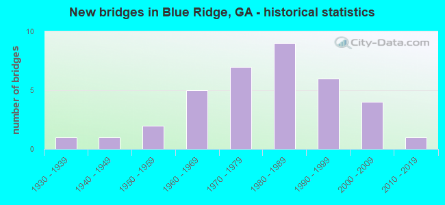
- New bridges - historical statistics
- 11930-1939
- 11940-1949
- 21950-1959
- 51960-1969
- 71970-1979
- 91980-1989
- 61990-1999
- 42000-2009
- 12010-2019
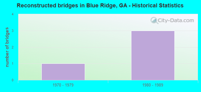
- Reconstructed bridges - Historical Statistics
- 11970-1979
- 31980-1989
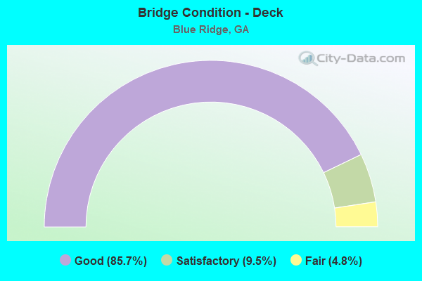
- Bridge Condition - Deck
- 85.7%Good
- 9.5%Satisfactory
- 4.8%Fair
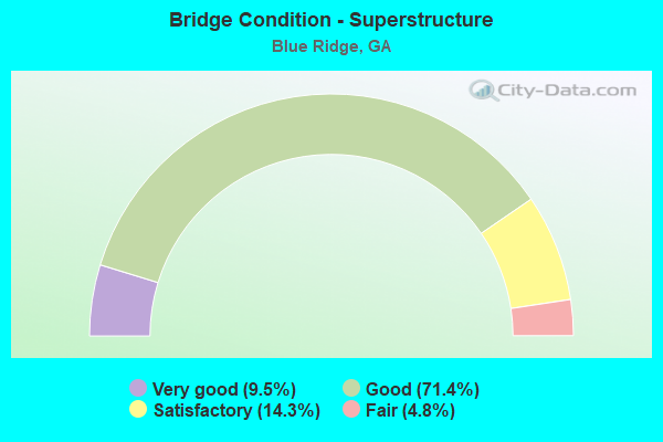
- Bridge Condition - Superstructure
- 9.5%Very good
- 71.4%Good
- 14.3%Satisfactory
- 4.8%Fair
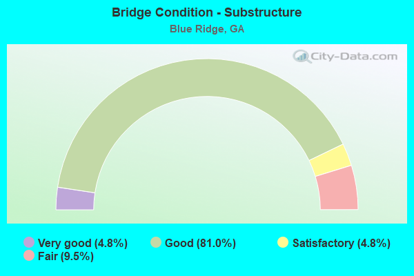
- Bridge Condition - Substructure
- 4.8%Very good
- 81.0%Good
- 4.8%Satisfactory
- 9.5%Fair
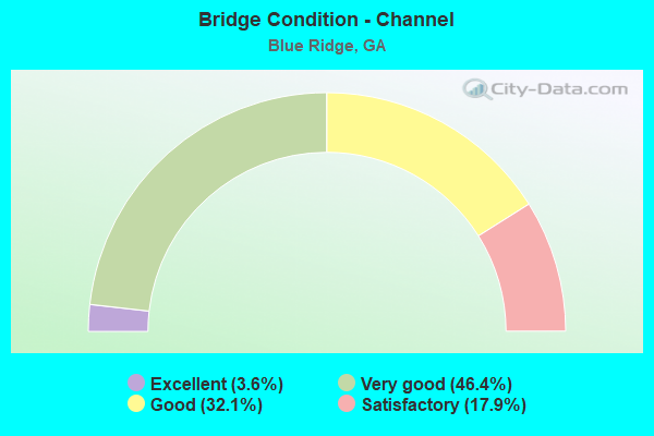
- Bridge Condition - Channel
- 3.6%Excellent
- 46.4%Very good
- 32.1%Good
- 17.9%Satisfactory
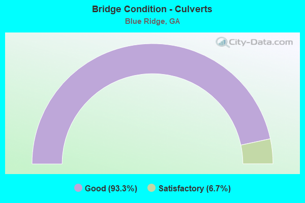
- Bridge Condition - Culverts
- 93.3%Good
- 6.7%Satisfactory
Find on map >> Show street view
Structure Number: 670055, Location: IN WEST SMYRNA (Lat: 33.879578, Lng: -84.532928), Route carried "on" structure: State highway 280, Year Built: 1944, Year Reconstructed: 1976, Status: Open, Structure Length: 0.82m (2.69ft), Average Daily Traffic: 26,790 (year 2012), Truck Traffic: 1%, Average Future Daily Traffic: 40,185 (year 2032), Design Load: H 15, Features Intersected: E FORK NICKAJACK CRK, Facility Carried by Structure: SOUTH COBB DRIVE
Minimum Vertical Clearance: 30+ m (98+ ft), Kilometerpoint: 9.656, Lanes on structure: 5, Base Highway Network: Yes, Owner: State Highway Agency, Approaching Roadway Width: 20.1m (65.9ft), Skew: 3 degrees, Material/Design: Concrete, Design/Construction: Culvert, Number Of Spans In Main Unit: 3, Length of Maximum Span: 2.4m (7.9ft), Curb or Sidewalk Widths: Left: 1.5m (4.9ft), Right: 1.5m (4.9ft)
Condition: Channel: Good, Culverts: Good, Operating Rating: 43.5 metric tons, Method Used To Determine Operating Rating: Field evaluation and documented engineering judgment, Inventory Rating: 24.4 metric tons, Method Used To Determine Inventory Rating: Field evaluation and documented engineering judgment, Structural Evaluation: Equal to present minimum criteria, Waterway Adequacy: Superior to present desirable criteria, Approach Roadway Alignment: Equal to present desirable criteria, Designated Inspection Frequency: Every 24 months, Inspection Date: June 2021, Bridge Improvement Cost: $192,000, Roadway Improvement Cost: $19,000, Total Project Cost: $288,000
Find on map >> Show street view
Structure Number: 670167, Location: IN EAST SMYRNA (Lat: 33.880347, Lng: -84.509128), Route carried "on" structure: City street 9036, Year Built: 1967, Status: Posted for load, Structure Length: 6.68m (21.92ft), Average Daily Traffic: 27,770 (year 2012), Truck Traffic: 1%, Average Future Daily Traffic: 41,655 (year 2032), Design Load: HS 20, Features Intersected: CSX RAILROAD (340375A), Facility Carried by Structure: SPRING ROAD
Minimum Vertical Clearance: 30+ m (98+ ft), Kilometerpoint: 12.875, Lanes on structure: 4, Base Highway Network: Yes, Owner: County Highway Agency, Approaching Roadway Width: 15.8m (51.8ft), Skew: 3 degrees, Material/Design: Steel, Design/Construction: Stringer/Multi-beam, Number Of Spans In Main Unit: 3, Length of Maximum Span: 24.4m (80.1ft), Curb or Sidewalk Widths: Left: 1.5m (4.9ft), Right: 1.5m (4.9ft), Curb-To-Curb Width: 15.8m (51.8ft), Out-to-Out Width: 19.9m (65.3ft)
Condition: Deck: Satisfactory, Superstructure: Good, Substructure: Good, Operating Rating: 31.7 metric tons, Method Used To Determine Operating Rating: Load Factor (LF), Inventory Rating: 19.0 metric tons, Method Used To Determine Inventory Rating: Load Factor (LF), Structural Evaluation: Meets minimum limits, Deck Geometry: Meets minimum limits, Underclear: Equal to present minimum criteria, Approach Roadway Alignment: Equal to present desirable criteria, Designated Inspection Frequency: Every 24 months, Inspection Date: August 2021, Bridge Improvement Cost: $1,322,000, Roadway Improvement Cost: $132,000, Total Project Cost: $1,984,000, Deck Structure Type: Concrete Cast-file-Place
Find on map >> Show street view
Structure Number: 67509, Location: 3 MI SE OF SMYRNA (Lat: 33.839100, Lng: -84.507400), Route carried "on" structure: City street 1897, Year Built: 1978, Status: Open, Structure Length: 3.05m (10.01ft), Average Daily Traffic: 1,930 (year 2012), Truck Traffic: 1%, Average Future Daily Traffic: 2,895 (year 2032), Design Load: H 15, Features Intersected: ABANDONED R/R, Facility Carried by Structure: CAMP HIGHLAND ROAD
Minimum Vertical Clearance: 30+ m (98+ ft), Kilometerpoint: 1.609, Lanes on structure: 2, Base Highway Network: Yes, Owner: County Highway Agency, Approaching Roadway Width: 6.7m (22.0ft), Material/Design: Concrete, Design/Construction: Tee Beam, Number Of Spans In Main Unit: 3, Length of Maximum Span: 10.4m (34.1ft), Curb or Sidewalk Widths: Left: 1.2m (3.9ft), Right: 0.0m, Curb-To-Curb Width: 7.3m (24.0ft), Out-to-Out Width: 9.0m (29.5ft)
Condition: Deck: Good, Superstructure: Good, Substructure: Good, Operating Rating: 34.4 metric tons, Method Used To Determine Operating Rating: Allowable Stress (AS), Inventory Rating: 21.7 metric tons, Method Used To Determine Inventory Rating: Allowable Stress (AS), Structural Evaluation: Somewhat better than minimum adequacy, Deck Geometry: Meets minimum limits, Approach Roadway Alignment: Equal to present desirable criteria, Length Of Structure Improvement: 43.28m (141.99ft), Designated Inspection Frequency: Every 24 months, Inspection Date: June 2021, Bridge Improvement Cost: $391,000, Roadway Improvement Cost: $39,000, Total Project Cost: $586,000, Deck Structure Type: Concrete Cast-file-Place
Find on map >> Show street view
Structure Number: 675152, Location: IN SE SMYRNA (Lat: 33.842289, Lng: -84.512439), Route carried "on" structure: County highway 5300, Year Built: 1986, Status: Open, Structure Length: 0.98m (3.22ft), Average Daily Traffic: 1,930 (year 2012), Truck Traffic: 1%, Average Future Daily Traffic: 2,895 (year 2032), Design Load: HS 20, Features Intersected: NICKAJACK CREEK TRIB, Facility Carried by Structure: LAUREL BRIDGE DRIV
Minimum Vertical Clearance: 30+ m (98+ ft), Kilometerpoint: 0.000, Lanes on structure: 2, Base Highway Network: Yes, Owner: County Highway Agency, Approaching Roadway Width: 7.9m (25.9ft), Material/Design: Concrete, Design/Construction: Culvert, Number Of Spans In Main Unit: 3, Length of Maximum Span: 3.0m (9.8ft)
Condition: Channel: Very good, Culverts: Good, Operating Rating: 55.3 metric tons, Method Used To Determine Operating Rating: Field evaluation and documented engineering judgment, Inventory Rating: 32.6 metric tons, Method Used To Determine Inventory Rating: Field evaluation and documented engineering judgment, Structural Evaluation: Better than present minimum criteria, Waterway Adequacy: Superior to present desirable criteria, Approach Roadway Alignment: Equal to present desirable criteria, Designated Inspection Frequency: Every 24 months, Inspection Date: March 2021
Find on map >> Show street view
Structure Number: 675175, Location: 1 MILES WEST OF SMYRNA (Lat: 33.877914, Lng: -84.539547), Route carried "on" structure: City street 1741, Year Built: 1997, Status: Open, Structure Length: 1.89m (6.20ft), Average Daily Traffic: 1,930 (year 2012), Truck Traffic: 1%, Average Future Daily Traffic: 2,895 (year 2032), Design Load: HS 20, Features Intersected: E FORK NICKAJACK CREEK, Facility Carried by Structure: OLD CONCORD ROAD
Minimum Vertical Clearance: 30+ m (98+ ft), Kilometerpoint: 1.609, Lanes on structure: 2, Base Highway Network: Yes, Owner: County Highway Agency, Approaching Roadway Width: 8.2m (26.9ft), Skew: 3 degrees, Material/Design: Prestressed concrete, Design/Construction: Stringer/Multi-beam, Number Of Spans In Main Unit: 1, Length of Maximum Span: 18.9m (62.0ft), Curb or Sidewalk Widths: Left: 2.3m (7.5ft), Right: 2.3m (7.5ft), Curb-To-Curb Width: 8.2m (26.9ft), Out-to-Out Width: 12.8m (42.0ft)
Condition: Deck: Good, Superstructure: Very good, Substructure: Good, Channel: Very good, Operating Rating: 45.3 metric tons, Method Used To Determine Operating Rating: Allowable Stress (AS), Inventory Rating: 32.6 metric tons, Method Used To Determine Inventory Rating: Allowable Stress (AS), Structural Evaluation: Better than present minimum criteria, Deck Geometry: Meets minimum limits, Waterway Adequacy: Superior to present desirable criteria, Approach Roadway Alignment: Equal to present desirable criteria, Length Of Structure Improvement: 41.45m (135.99ft), Designated Inspection Frequency: Every 24 months, Inspection Date: August 2021, Bridge Improvement Cost: $242,000, Roadway Improvement Cost: $24,000, Total Project Cost: $363,000, Deck Structure Type: Concrete Cast-file-Place
Find on map >> Show street view
Structure Number: 675182, Location: 3.1 S OF SMYRNA (Lat: 33.838469, Lng: -84.514547), Route carried "on" structure: City street 2835, Year Built: 1997, Status: Open, Structure Length: 21.58m (70.80ft), Average Daily Traffic: 28,820 (year 2012), Truck Traffic: 1%, Average Future Daily Traffic: 43,230 (year 2032), Design Load: HS 20+Mod, Features Intersected: LAUREL LAKE TRIB., Facility Carried by Structure: EAST-WEST CONN
Minimum Vertical Clearance: 30+ m (98+ ft), Kilometerpoint: 11.265, Lanes on structure: 4, Base Highway Network: Yes, Owner: County Highway Agency, Approaching Roadway Width: 17.1m (56.1ft), Skew: 20 degrees, Material/Design: Prestressed concrete, Design/Construction: Stringer/Multi-beam, Number Of Spans In Main Unit: 8, Length of Maximum Span: 29.6m (97.1ft), Curb-To-Curb Width: 24.4m (80.1ft), Out-to-Out Width: 25.1m (82.3ft)
Condition: Deck: Good, Superstructure: Good, Substructure: Good, Channel: Very good, Operating Rating: 63.5 metric tons, Method Used To Determine Operating Rating: Load Factor (LF), Inventory Rating: 33.5 metric tons, Method Used To Determine Inventory Rating: Load Factor (LF), Structural Evaluation: Better than present minimum criteria, Deck Geometry: Superior to present desirable criteria, Waterway Adequacy: Equal to present desirable criteria, Approach Roadway Alignment: Equal to present desirable criteria, Designated Inspection Frequency: Every 24 months, Inspection Date: October 2021, Bridge Improvement Cost: $4,275,000, Roadway Improvement Cost: $428,000, Total Project Cost: $6,413,000, Deck Structure Type: Concrete Cast-file-Place
Find on map >> Show street view
Structure Number: 675183, Location: 3.1 MILES SOUTH OF SMYRNA (Lat: 33.839333, Lng: -84.508242), Route carried "on" structure: City street 2835, Year Built: 1997, Status: Open, Structure Length: 3.66m (12.01ft), Average Daily Traffic: 28,820 (year 2012), Truck Traffic: 1%, Average Future Daily Traffic: 43,230 (year 2032), Design Load: HS 20+Mod, Features Intersected: ABANDONED RAILROAD, Facility Carried by Structure: EAST-WEST CONNECTO
Minimum Vertical Clearance: 30+ m (98+ ft), Kilometerpoint: 12.875, Lanes on structure: 4, Base Highway Network: Yes, Owner: County Highway Agency, Approaching Roadway Width: 17.7m (58.1ft), Skew: 23 degrees, Material/Design: Prestressed concrete, Design/Construction: Stringer/Multi-beam, Number Of Spans In Main Unit: 1, Length of Maximum Span: 36.6m (120.1ft), Curb-To-Curb Width: 29.3m (96.1ft), Out-to-Out Width: 30.2m (99.1ft)
Condition: Deck: Good, Superstructure: Good, Substructure: Good, Operating Rating: 46.2 metric tons, Method Used To Determine Operating Rating: Allowable Stress (AS), Inventory Rating: 32.6 metric tons, Method Used To Determine Inventory Rating: Allowable Stress (AS), Structural Evaluation: Better than present minimum criteria, Deck Geometry: Superior to present desirable criteria, Approach Roadway Alignment: Equal to present desirable criteria, Designated Inspection Frequency: Every 24 months, Inspection Date: August 2021, Bridge Improvement Cost: $725,000, Roadway Improvement Cost: $72,000, Total Project Cost: $1,087,000, Deck Structure Type: Concrete Cast-file-Place
Find on map >> Show street view
Structure Number: 675235, Location: IN CITY LIMITS OF SMYRNA (Lat: 33.886819, Lng: -84.547100), Route carried "on" structure: City street 5111, Year Built: 1972, Status: Open, Structure Length: 1.22m (4.00ft), Average Daily Traffic: 1,930 (year 2012), Truck Traffic: 1%, Average Future Daily Traffic: 2,895 (year 2032), Design Load: H 15, Features Intersected: NICKAJACK CREEK, Facility Carried by Structure: VINEYARD WAY
Minimum Vertical Clearance: 30+ m (98+ ft), Kilometerpoint: 0.000, Lanes on structure: 2, Base Highway Network: Yes, Owner: City or Municipal Highway Agency, Approaching Roadway Width: 6.4m (21.0ft), Material/Design: Prestressed concrete, Design/Construction: Channel Beam, Number Of Spans In Main Unit: 2, Length of Maximum Span: 6.1m (20.0ft), Curb-To-Curb Width: 7.3m (24.0ft), Out-to-Out Width: 7.9m (25.9ft)
Condition: Deck: Good, Superstructure: Satisfactory, Substructure: Good, Channel: Good, Operating Rating: 43.5 metric tons, Method Used To Determine Operating Rating: Load Factor (LF), Inventory Rating: 26.3 metric tons, Method Used To Determine Inventory Rating: Load Factor (LF), Structural Evaluation: Equal to present minimum criteria, Deck Geometry: Meets minimum limits, Waterway Adequacy: Better than present minimum criteria, Approach Roadway Alignment: Better than present minimum criteria, Designated Inspection Frequency: Every 24 months, Inspection Date: April 2021, Bridge Improvement Cost: $156,000, Roadway Improvement Cost: $16,000, Total Project Cost: $234,000, Deck Structure Type: Concrete Precast Panels, Wearing Surface/Protective System: Wearing Surface: Bituminous
Find on map >> Show street view
Structure Number: 675329, Location: 3 MI SE OF SMYRNA (Lat: 33.855003, Lng: -84.483331), Route carried "on" structure: County highway 1921, Year Built: 2016, Status: Open, Structure Length: 5.55m (18.21ft), Average Daily Traffic: 240 (year 2012), Truck Traffic: 1%, Average Future Daily Traffic: 360 (year 2032), Design Load: HS 20+Mod, Features Intersected: I-285, Facility Carried by Structure: ORCHARD ROAD
Minimum Vertical Clearance: 30+ m (98+ ft), Kilometerpoint: 1.609, Lanes on structure: 2, Lanes under structure: 8, Base Highway Network: Yes, Owner: State Highway Agency, Approaching Roadway Width: 8.5m (27.9ft), Material/Design: Prestressed concrete, Design/Construction: Stringer/Multi-beam, Number Of Spans In Main Unit: 2, Length of Maximum Span: 27.7m (90.9ft), Curb or Sidewalk Widths: Left: 1.7m (5.6ft), Right: 1.7m (5.6ft), Curb-To-Curb Width: 8.5m (27.9ft), Out-to-Out Width: 12.2m (40.0ft)
Condition: Deck: Good, Superstructure: Very good, Substructure: Good, Operating Rating: 65.3 metric tons, Method Used To Determine Operating Rating: Load Factor (LF), Inventory Rating: 37.1 metric tons, Method Used To Determine Inventory Rating: Load Factor (LF), Structural Evaluation: Better than present minimum criteria, Deck Geometry: High priority of replacement, Underclear: Better than present minimum criteria, Approach Roadway Alignment: Equal to present desirable criteria, Length Of Structure Improvement: 6.64m (21.78ft), Designated Inspection Frequency: Every 24 months, Inspection Date: September 2021, Bridge Improvement Cost: $16,132,000, Roadway Improvement Cost: $1,613,000, Total Project Cost: $24,198,000 ( Estimate for 2017), Deck Structure Type: Concrete Cast-file-Place
Find on map >> Show street view
Structure Number: 1110001, Location: 7 MI NW OF BLUE RIDGE (Lat: 34.895578, Lng: -84.437478), Route carried "on" structure: County highway 271, Year Built: 1974, Status: Open, Structure Length: 1.37m (4.49ft), Average Daily Traffic: 1,280 (year 2012), Truck Traffic: 5%, Average Future Daily Traffic: 1,920 (year 2032), Design Load: HS 20+Mod, Features Intersected: FIGHTINGTOWN CREEK, Facility Carried by Structure: OLD SR 2 / HWY 2
Minimum Vertical Clearance: 30+ m (98+ ft), Kilometerpoint: 6.437, Lanes on structure: 2, Base Highway Network: Yes, Owner: County Highway Agency, Approaching Roadway Width: 6.4m (21.0ft), Skew: 1 degrees, Material/Design: Concrete, Design/Construction: Culvert, Number Of Spans In Main Unit: 4, Length of Maximum Span: 3.0m (9.8ft)
Condition: Channel: Good, Culverts: Satisfactory, Operating Rating: 55.3 metric tons, Method Used To Determine Operating Rating: Field evaluation and documented engineering judgment, Inventory Rating: 32.6 metric tons, Method Used To Determine Inventory Rating: Field evaluation and documented engineering judgment, Structural Evaluation: Equal to present minimum criteria, Waterway Adequacy: Superior to present desirable criteria, Approach Roadway Alignment: Equal to present desirable criteria, Designated Inspection Frequency: Every 24 months, Inspection Date: October 2021, Bridge Improvement Cost: $176,000, Roadway Improvement Cost: $18,000, Total Project Cost: $264,000
Find on map >> Show street view
Structure Number: 1110003, Location: 2 MI N OF BLUE RIDGE (Lat: 34.889989, Lng: -84.346500), Route carried "on" structure: State highway 5, Year Built: 1954, Status: Open, Structure Length: 0.88m (2.89ft), Average Daily Traffic: 12,210 (year 2012), Truck Traffic: 6%, Average Future Daily Traffic: 18,315 (year 2032), Design Load: H 15, Features Intersected: LITTLE SUGAR CREEK
Minimum Vertical Clearance: 30+ m (98+ ft), Kilometerpoint: 9.656, Lanes on structure: 2, Base Highway Network: Yes, Owner: State Highway Agency, Approaching Roadway Width: 8.5m (27.9ft), Material/Design: Concrete, Design/Construction: Culvert, Number Of Spans In Main Unit: 3, Length of Maximum Span: 2.7m (8.9ft)
Condition: Channel: Very good, Culverts: Good, Structural Evaluation: Better than present minimum criteria, Waterway Adequacy: Superior to present desirable criteria, Approach Roadway Alignment: Equal to present desirable criteria, Designated Inspection Frequency: Every 24 months, Inspection Date: November 2021, Bridge Improvement Cost: $113,000, Roadway Improvement Cost: $11,000, Total Project Cost: $170,000
Find on map >> Show street view
Structure Number: 1110004, Location: 1.5 MI N OF BLUE RIDGE (Lat: 34.885828, Lng: -84.335989), Route carried "on" structure: State highway 5, Year Built: 1953, Status: Open, Structure Length: 0.98m (3.22ft), Average Daily Traffic: 12,210 (year 2012), Truck Traffic: 6%, Average Future Daily Traffic: 18,315 (year 2032), Design Load: H 15, Features Intersected: SUGAR CREEK
Minimum Vertical Clearance: 30+ m (98+ ft), Kilometerpoint: 8.047, Lanes on structure: 2, Base Highway Network: Yes, Owner: State Highway Agency, Approaching Roadway Width: 8.5m (27.9ft), Material/Design: Concrete, Design/Construction: Culvert, Number Of Spans In Main Unit: 3, Length of Maximum Span: 3.0m (9.8ft)
Condition: Channel: Satisfactory, Culverts: Good, Structural Evaluation: Better than present minimum criteria, Waterway Adequacy: Superior to present desirable criteria, Approach Roadway Alignment: Equal to present desirable criteria, Designated Inspection Frequency: Every 24 months, Inspection Date: November 2021, Bridge Improvement Cost: $125,000, Roadway Improvement Cost: $13,000, Total Project Cost: $188,000
Find on map >> Show street view
Structure Number: 1110005, Location: BLUE RIDGE - NORTHSIDE (Lat: 34.874258, Lng: -84.318508), Route carried "on" structure: US 76, Year Built: 1981, Status: Open, Structure Length: 11.89m (39.01ft), Average Daily Traffic: 20,170 (year 2010), Truck Traffic: 1%, Average Future Daily Traffic: 30,255 (year 2030), Design Load: HS 20+Mod, Features Intersected: CS 103 (ADA ST)- CSX RR
Minimum Vertical Clearance: 30+ m (98+ ft), Kilometerpoint: 6.437, Lanes on structure: 2, Lanes under structure: 2, Base Highway Network: Yes, Owner: State Highway Agency, Approaching Roadway Width: 8.2m (26.9ft), Skew: 13 degrees, Material/Design: Prestressed concrete, Design/Construction: Stringer/Multi-beam, Number Of Spans In Main Unit: 6, Length of Maximum Span: 23.8m (78.1ft), Curb-To-Curb Width: 12.8m (42.0ft), Out-to-Out Width: 13.8m (45.3ft)
Condition: Deck: Good, Superstructure: Good, Substructure: Good, Operating Rating: 70.7 metric tons, Method Used To Determine Operating Rating: Load Factor (LF), Inventory Rating: 42.6 metric tons, Method Used To Determine Inventory Rating: Load Factor (LF), Structural Evaluation: Better than present minimum criteria, Deck Geometry: Equal to present desirable criteria, Underclear: Meets minimum limits, Approach Roadway Alignment: Equal to present desirable criteria, Designated Inspection Frequency: Every 24 months, Inspection Date: November 2021, Bridge Improvement Cost: $1,524,000, Roadway Improvement Cost: $152,000, Total Project Cost: $2,286,000, Deck Structure Type: Concrete Cast-file-Place
Find on map >> Show street view
Structure Number: 1110006, Location: BLUE RIDGE - NORTHSIDE (Lat: 34.874478, Lng: -84.318339), Route carried "on" structure: US 76, Year Built: 1981, Status: Open, Structure Length: 11.89m (39.01ft), Average Daily Traffic: 10,630 (year 2010), Truck Traffic: 12%, Average Future Daily Traffic: 15,945 (year 2030), Design Load: HS 20+Mod, Features Intersected: CS 103 (ADA ST)- CSX RR
Minimum Vertical Clearance: 30+ m (98+ ft), Kilometerpoint: 6.437, Lanes on structure: 2, Lanes under structure: 2, Owner: State Highway Agency, Approaching Roadway Width: 9.1m (29.9ft), Skew: 13 degrees, Material/Design: Prestressed concrete, Design/Construction: Stringer/Multi-beam, Number Of Spans In Main Unit: 6, Length of Maximum Span: 23.8m (78.1ft), Curb-To-Curb Width: 12.8m (42.0ft), Out-to-Out Width: 13.8m (45.3ft)
Condition: Deck: Good, Superstructure: Good, Substructure: Good, Operating Rating: 71.6 metric tons, Method Used To Determine Operating Rating: Load Factor (LF), Inventory Rating: 42.6 metric tons, Method Used To Determine Inventory Rating: Load Factor (LF), Structural Evaluation: Better than present minimum criteria, Deck Geometry: Equal to present desirable criteria, Underclear: Superior to present desirable criteria, Approach Roadway Alignment: Equal to present desirable criteria, Designated Inspection Frequency: Every 24 months, Inspection Date: November 2021, Bridge Improvement Cost: $1,524,000, Roadway Improvement Cost: $152,000, Total Project Cost: $2,286,000, Deck Structure Type: Concrete Cast-file-Place
Find on map >> Show street view
Structure Number: 1110007, Location: 1.5 MI NE OF BLUE RIDGE (Lat: 34.876419, Lng: -84.300297), Route carried "on" structure: US 76, Year Built: 1981, Status: Open, Structure Length: 1.77m (5.81ft), Average Daily Traffic: 18,700 (year 2012), Truck Traffic: 6%, Average Future Daily Traffic: 28,050 (year 2032), Design Load: HS 20+Mod, Features Intersected: WEAVER CREEK
Minimum Vertical Clearance: 30+ m (98+ ft), Kilometerpoint: 8.047, Lanes on structure: 4, Base Highway Network: Yes, Owner: State Highway Agency, Approaching Roadway Width: 18.3m (60.0ft), Skew: 15 degrees, Material/Design: Concrete, Design/Construction: Culvert, Number Of Spans In Main Unit: 4, Length of Maximum Span: 4.0m (13.1ft)
Condition: Channel: Good, Culverts: Good, Structural Evaluation: Better than present minimum criteria, Waterway Adequacy: Superior to present desirable criteria, Approach Roadway Alignment: Equal to present desirable criteria, Designated Inspection Frequency: Every 24 months, Inspection Date: October 2021, Bridge Improvement Cost: $350,000, Roadway Improvement Cost: $35,000, Total Project Cost: $525,000
Find on map >> Show street view
Structure Number: 1110008, Location: 2.5 MI NE OF BLUE RIDGE (Lat: 34.889089, Lng: -84.286858), Route carried "on" structure: US 76, Year Built: 1981, Status: Open, Structure Length: 10.52m (34.51ft), Average Daily Traffic: 18,700 (year 2012), Truck Traffic: 6%, Average Future Daily Traffic: 28,050 (year 2032), Design Load: HS 20+Mod, Features Intersected: TOCCOA RIVER
Minimum Vertical Clearance: 30+ m (98+ ft), Kilometerpoint: 11.265, Lanes on structure: 2, Base Highway Network: Yes, Owner: State Highway Agency, Approaching Roadway Width: 9.1m (29.9ft), Skew: 10 degrees, Material/Design: Prestressed concrete, Design/Construction: Stringer/Multi-beam, Number Of Spans In Main Unit: 5, Length of Maximum Span: 22.3m (73.2ft), Curb-To-Curb Width: 12.8m (42.0ft), Out-to-Out Width: 13.8m (45.3ft)
Condition: Deck: Good, Superstructure: Good, Substructure: Good, Channel: Very good, Operating Rating: 64.4 metric tons, Method Used To Determine Operating Rating: Load Factor (LF), Inventory Rating: 31.7 metric tons, Method Used To Determine Inventory Rating: Load Factor (LF), Structural Evaluation: Better than present minimum criteria, Deck Geometry: Equal to present desirable criteria, Waterway Adequacy: Equal to present desirable criteria, Approach Roadway Alignment: Equal to present desirable criteria, Designated Inspection Frequency: Every 24 months, Inspection Date: December 2021, Bridge Improvement Cost: $1,348,000, Roadway Improvement Cost: $135,000, Total Project Cost: $2,022,000, Deck Structure Type: Concrete Cast-file-Place
Find on map >> Show street view
Structure Number: 1110009, Location: 2.5 MI NE OF BLUE RIDGE (Lat: 34.889239, Lng: -84.286978), Route carried "on" structure: US 76, Year Built: 1981, Status: Open, Structure Length: 10.52m (34.51ft), Average Daily Traffic: 18,700 (year 2012), Truck Traffic: 6%, Average Future Daily Traffic: 28,050 (year 2032), Design Load: HS 20+Mod, Features Intersected: TOCCOA RIVER
Minimum Vertical Clearance: 30+ m (98+ ft), Kilometerpoint: 11.265, Lanes on structure: 2, Base Highway Network: Yes, Owner: State Highway Agency, Approaching Roadway Width: 9.1m (29.9ft), Skew: 10 degrees, Material/Design: Prestressed concrete, Design/Construction: Stringer/Multi-beam, Number Of Spans In Main Unit: 5, Length of Maximum Span: 22.3m (73.2ft), Curb-To-Curb Width: 12.8m (42.0ft), Out-to-Out Width: 13.8m (45.3ft)
Condition: Deck: Good, Superstructure: Good, Substructure: Good, Channel: Very good, Operating Rating: 58.9 metric tons, Method Used To Determine Operating Rating: Load Factor (LF), Inventory Rating: 29.9 metric tons, Method Used To Determine Inventory Rating: Load Factor (LF), Structural Evaluation: Better than present minimum criteria, Deck Geometry: Equal to present desirable criteria, Waterway Adequacy: Equal to present desirable criteria, Approach Roadway Alignment: Equal to present desirable criteria, Designated Inspection Frequency: Every 24 months, Inspection Date: December 2021, Bridge Improvement Cost: $1,348,000, Roadway Improvement Cost: $135,000, Total Project Cost: $2,022,000, Deck Structure Type: Concrete Cast-file-Place
Find on map >> Show street view
Structure Number: 1110015, Location: 3.5 MI SW OF BLUE RIDGE (Lat: 34.826639, Lng: -84.356428), Route carried "on" structure: US 76, Year Built: 1966, Year Reconstructed: 1987, Status: Open, Structure Length: 0.98m (3.22ft), Average Daily Traffic: 13,750 (year 2012), Truck Traffic: 10%, Average Future Daily Traffic: 20,625 (year 2032), Design Load: HS 20+Mod, Features Intersected: CHERRY LOG CREEK
Minimum Vertical Clearance: 30+ m (98+ ft), Kilometerpoint: 0.000, Lanes on structure: 4, Base Highway Network: Yes, Owner: State Highway Agency, Approaching Roadway Width: 18.3m (60.0ft), Skew: 10 degrees, Material/Design: Concrete, Design/Construction: Culvert, Number Of Spans In Main Unit: 3, Length of Maximum Span: 3.0m (9.8ft)
Condition: Channel: Very good, Culverts: Good, Structural Evaluation: Better than present minimum criteria, Waterway Adequacy: Superior to present desirable criteria, Approach Roadway Alignment: Equal to present desirable criteria, Designated Inspection Frequency: Every 24 months, Inspection Date: November 2021, Bridge Improvement Cost: $193,000, Roadway Improvement Cost: $19,000, Total Project Cost: $290,000
Find on map >> Show street view
Structure Number: 1110016, Location: BLUE RIDGE - WESTSIDE (Lat: 34.852069, Lng: -84.336939), Route carried "on" structure: US 76, Year Built: 1963, Year Reconstructed: 1987, Status: Open, Structure Length: 7.32m (24.02ft), Average Daily Traffic: 13,170 (year 2010), Truck Traffic: 1%, Average Future Daily Traffic: 19,755 (year 2031), Design Load: HS 20+Mod, Features Intersected: CSX RAILROAD (340791C)
Minimum Vertical Clearance: 30+ m (98+ ft), Kilometerpoint: 3.219, Lanes on structure: 5, Lanes under structure: 1, Base Highway Network: Yes, Owner: State Highway Agency, Approaching Roadway Width: 21.3m (69.9ft), Skew: 4 degrees, Material/Design: Steel, Design/Construction: Stringer/Multi-beam, Number Of Spans In Main Unit: 5, Length of Maximum Span: 17.4m (57.1ft), Curb-To-Curb Width: 26.2m (86.0ft), Out-to-Out Width: 27.2m (89.2ft)
Condition: Deck: Fair, Superstructure: Good, Substructure: Fair, Operating Rating: 53.5 metric tons, Method Used To Determine Operating Rating: Load Factor (LF), Inventory Rating: 31.7 metric tons, Method Used To Determine Inventory Rating: Load Factor (LF), Structural Evaluation: Somewhat better than minimum adequacy, Deck Geometry: Superior to present desirable criteria, Underclear: Meets minimum limits, Approach Roadway Alignment: Equal to present desirable criteria, Designated Inspection Frequency: Every 24 months, Inspection Date: November 2021, Bridge Improvement Cost: $1,705,000, Roadway Improvement Cost: $170,000, Total Project Cost: $2,557,000, Deck Structure Type: Concrete Cast-file-Place
Find on map >> Show street view
Structure Number: 1110027, Location: 0.5 MI N OF BLUE RIDGE (Lat: 34.874989, Lng: -84.312389), Route carried "on" structure: County highway 87, Year Built: 1981, Status: Open, Structure Length: 11.61m (38.09ft), Average Daily Traffic: 490 (year 2012), Truck Traffic: 1%, Average Future Daily Traffic: 735 (year 2032), Design Load: HS 20+Mod, Features Intersected: SR 515 (US 76), Facility Carried by Structure: WINDY RIDGE ROAD
Minimum Vertical Clearance: 30+ m (98+ ft), Kilometerpoint: 0.000, Lanes on structure: 2, Lanes under structure: 5, Base Highway Network: Yes, Owner: State Highway Agency, Approaching Roadway Width: 6.1m (20.0ft), Skew: 4 degrees, Material/Design: Prestressed concrete continuous, Design/Construction: Box Beam or Girders - Single/Spread, Number Of Spans In Main Unit: 2, Length of Maximum Span: 59.4m (194.9ft), Curb-To-Curb Width: 10.2m (33.5ft), Out-to-Out Width: 11.1m (36.4ft)
Condition: Deck: Good, Superstructure: Good, Substructure: Good, Operating Rating: 46.2 metric tons, Method Used To Determine Operating Rating: Allowable Stress (AS), Inventory Rating: 32.6 metric tons, Method Used To Determine Inventory Rating: Allowable Stress (AS), Structural Evaluation: Better than present minimum criteria, Deck Geometry: Equal to present minimum criteria, Underclear: Superior to present desirable criteria, Approach Roadway Alignment: Equal to present desirable criteria, Designated Inspection Frequency: Every 24 months, Inspection Date: November 2021, Deck Structure Type: Concrete Cast-file-Place, Wearing Surface/Protective System: Wearing Surface: Epoxy Overlay
Find on map >> Show street view
Structure Number: 1110032, Location: 3 MI SE OF BLUE RIDGE (Lat: 34.831839, Lng: -84.299658), Route carried "on" structure: County highway 810, Year Built: 1970, Status: Open, Structure Length: 1.22m (4.00ft), Average Daily Traffic: 1,760 (year 2012), Truck Traffic: 1%, Average Future Daily Traffic: 2,640 (year 2032), Design Load: H 15, Features Intersected: STILL HOUSE BRANCH, Facility Carried by Structure: ASKA ROAD
Minimum Vertical Clearance: 30+ m (98+ ft), Kilometerpoint: 20.921, Lanes on structure: 2, Base Highway Network: Yes, Owner: County Highway Agency, Approaching Roadway Width: 7.0m (23.0ft), Skew: 2 degrees, Material/Design: Concrete, Design/Construction: Culvert, Number Of Spans In Main Unit: 4, Length of Maximum Span: 2.7m (8.9ft)
Condition: Channel: Satisfactory, Culverts: Good, Structural Evaluation: Better than present minimum criteria, Waterway Adequacy: Superior to present desirable criteria, Approach Roadway Alignment: Equal to present desirable criteria, Designated Inspection Frequency: Every 24 months, Inspection Date: October 2021, Bridge Improvement Cost: $156,000, Roadway Improvement Cost: $16,000, Total Project Cost: $234,000
Find on map >> Show street view
Structure Number: 1110033, Location: 2.5 MI SE OF BLUE RIDGE (Lat: 34.838569, Lng: -84.297808), Route carried "on" structure: County highway 810, Year Built: 1970, Status: Open, Structure Length: 1.01m (3.31ft), Average Daily Traffic: 1,760 (year 2012), Truck Traffic: 1%, Average Future Daily Traffic: 2,640 (year 2032), Design Load: H 15, Features Intersected: STILL HOUSE BRANCH, Facility Carried by Structure: ASKA ROAD
Minimum Vertical Clearance: 30+ m (98+ ft), Kilometerpoint: 22.531, Lanes on structure: 2, Base Highway Network: Yes, Owner: County Highway Agency, Approaching Roadway Width: 6.7m (22.0ft), Skew: 3 degrees, Material/Design: Concrete, Design/Construction: Culvert, Number Of Spans In Main Unit: 3, Length of Maximum Span: 3.0m (9.8ft)
Condition: Channel: Very good, Culverts: Good, Operating Rating: 41.7 metric tons, Method Used To Determine Operating Rating: Field evaluation and documented engineering judgment, Inventory Rating: 24.4 metric tons, Method Used To Determine Inventory Rating: Field evaluation and documented engineering judgment, Structural Evaluation: Equal to present minimum criteria, Waterway Adequacy: Superior to present desirable criteria, Approach Roadway Alignment: Equal to present desirable criteria, Designated Inspection Frequency: Every 24 months, Inspection Date: October 2021, Bridge Improvement Cost: $129,000, Roadway Improvement Cost: $13,000, Total Project Cost: $193,000
Find on map >> Show street view
Structure Number: 1110034, Location: 2 MI SE OF BLUE RIDGE (Lat: 34.844250, Lng: -84.300808), Route carried "on" structure: County highway 222, Year Built: 1970, Status: Open, Structure Length: 1.19m (3.90ft), Average Daily Traffic: 1,760 (year 2012), Truck Traffic: 1%, Average Future Daily Traffic: 2,640 (year 2032), Design Load: H 15, Features Intersected: STILL HOUSE BRANCH, Facility Carried by Structure: ASKA ROAD
Minimum Vertical Clearance: 30+ m (98+ ft), Kilometerpoint: 22.531, Lanes on structure: 2, Base Highway Network: Yes, Owner: County Highway Agency, Approaching Roadway Width: 6.4m (21.0ft), Material/Design: Concrete, Design/Construction: Culvert, Number Of Spans In Main Unit: 4, Length of Maximum Span: 2.7m (8.9ft)
Condition: Channel: Good, Culverts: Good, Operating Rating: 41.7 metric tons, Method Used To Determine Operating Rating: Field evaluation and documented engineering judgment, Inventory Rating: 24.4 metric tons, Method Used To Determine Inventory Rating: Field evaluation and documented engineering judgment, Structural Evaluation: Equal to present minimum criteria, Waterway Adequacy: Superior to present desirable criteria, Approach Roadway Alignment: Equal to present desirable criteria, Designated Inspection Frequency: Every 24 months, Inspection Date: October 2021, Bridge Improvement Cost: $152,000, Roadway Improvement Cost: $15,000, Total Project Cost: $229,000
Find on map >> Show street view
Structure Number: 1110035, Location: 1.5 MI SE OF BLUE RIDGE (Lat: 34.859439, Lng: -84.302219), Route carried "on" structure: County highway 810, Year Built: 1970, Status: Open, Structure Length: 1.40m (4.59ft), Average Daily Traffic: 3,000 (year 2012), Truck Traffic: 1%, Average Future Daily Traffic: 4,500 (year 2032), Design Load: H 15, Features Intersected: WEAVER CREEK, Facility Carried by Structure: ASKA ROAD
Minimum Vertical Clearance: 30+ m (98+ ft), Kilometerpoint: 24.140, Lanes on structure: 2, Base Highway Network: Yes, Owner: County Highway Agency, Approaching Roadway Width: 6.7m (22.0ft), Skew: 4 degrees, Material/Design: Concrete, Design/Construction: Culvert, Number Of Spans In Main Unit: 3, Length of Maximum Span: 4.3m (14.1ft)
Condition: Channel: Very good, Culverts: Good, Operating Rating: 41.7 metric tons, Method Used To Determine Operating Rating: Field evaluation and documented engineering judgment, Inventory Rating: 24.4 metric tons, Method Used To Determine Inventory Rating: Field evaluation and documented engineering judgment, Structural Evaluation: Equal to present minimum criteria, Waterway Adequacy: Superior to present desirable criteria, Approach Roadway Alignment: Equal to present desirable criteria, Designated Inspection Frequency: Every 24 months, Inspection Date: October 2021, Bridge Improvement Cost: $180,000, Roadway Improvement Cost: $18,000, Total Project Cost: $270,000
Find on map >> Show street view
Structure Number: 1110036, Location: 1 MI E OF BLUE RIDGE (Lat: 34.872739, Lng: -84.302078), Route carried "on" structure: County highway 810, Year Built: 1980, Status: Open, Structure Length: 1.10m (3.61ft), Average Daily Traffic: 1,250 (year 2012), Truck Traffic: 1%, Average Future Daily Traffic: 1,875 (year 2032), Design Load: HS 20+Mod, Features Intersected: WEAVER CREEK
Minimum Vertical Clearance: 30+ m (98+ ft), Kilometerpoint: 25.750, Lanes on structure: 2, Base Highway Network: Yes, Owner: County Highway Agency, Approaching Roadway Width: 7.3m (24.0ft), Skew: 2 degrees, Material/Design: Concrete, Design/Construction: Culvert, Number Of Spans In Main Unit: 3, Length of Maximum Span: 3.4m (11.2ft)
Condition: Channel: Good, Culverts: Good, Operating Rating: 55.3 metric tons, Method Used To Determine Operating Rating: Field evaluation and documented engineering judgment, Inventory Rating: 32.6 metric tons, Method Used To Determine Inventory Rating: Field evaluation and documented engineering judgment, Structural Evaluation: Better than present minimum criteria, Waterway Adequacy: Superior to present desirable criteria, Approach Roadway Alignment: Equal to present desirable criteria, Designated Inspection Frequency: Every 24 months, Inspection Date: October 2021, Bridge Improvement Cost: $141,000, Roadway Improvement Cost: $14,000, Total Project Cost: $211,000
Find on map >> Show street view
Structure Number: 1110042, Location: 1.5 MI NW OF BLUE RIDGE (Lat: 34.879689, Lng: -84.346458), Route carried "on" structure: County highway 1008, Year Built: 1960, Status: Open, Structure Length: 1.01m (3.31ft), Average Daily Traffic: 2,080 (year 2012), Truck Traffic: 1%, Average Future Daily Traffic: 3,120 (year 2032), Design Load: H 15, Features Intersected: SUGAR CREEK, Facility Carried by Structure: SUGAR CREEK ROAD
Minimum Vertical Clearance: 30+ m (98+ ft), Kilometerpoint: 8.047, Lanes on structure: 2, Base Highway Network: Yes, Owner: County Highway Agency, Approaching Roadway Width: 5.8m (19.0ft), Material/Design: Concrete, Design/Construction: Culvert, Number Of Spans In Main Unit: 3, Length of Maximum Span: 3.0m (9.8ft), Curb or Sidewalk Widths: Left: 0.4m (1.3ft), Right: 0.4m (1.3ft), Curb-To-Curb Width: 7.2m (23.6ft), Out-to-Out Width: 8.1m (26.6ft)
Condition: Channel: Satisfactory, Culverts: Good, Operating Rating: 41.7 metric tons, Method Used To Determine Operating Rating: Field evaluation and documented engineering judgment, Inventory Rating: 24.4 metric tons, Method Used To Determine Inventory Rating: Field evaluation and documented engineering judgment, Structural Evaluation: Equal to present minimum criteria, Deck Geometry: High priority of replacement, Waterway Adequacy: Superior to present desirable criteria, Approach Roadway Alignment: Equal to present desirable criteria, Length Of Structure Improvement: 7.44m (24.41ft), Designated Inspection Frequency: Every 24 months, Inspection Date: November 2021, Bridge Improvement Cost: $129,000, Roadway Improvement Cost: $13,000, Total Project Cost: $193,000
Find on map >> Show street view
Structure Number: 1115022, Location: 2.9 MI W OF MORGANTON (Lat: 34.881758, Lng: -84.295408), Route carried "on" structure: County highway 89, Year Built: 1988, Status: Open, Structure Length: 0.98m (3.22ft), Average Daily Traffic: 490 (year 2012), Truck Traffic: 1%, Average Future Daily Traffic: 735 (year 2032), Design Load: HS 20+Mod, Features Intersected: WEAVER CREEK, Facility Carried by Structure: McKINNEY ROAD
Minimum Vertical Clearance: 30+ m (98+ ft), Kilometerpoint: 1.609, Lanes on structure: 2, Base Highway Network: Yes, Owner: County Highway Agency, Approaching Roadway Width: 7.0m (23.0ft), Material/Design: Concrete, Design/Construction: Culvert, Number Of Spans In Main Unit: 3, Length of Maximum Span: 3.0m (9.8ft)
Condition: Channel: Satisfactory, Culverts: Good, Operating Rating: 55.3 metric tons, Method Used To Determine Operating Rating: Field evaluation and documented engineering judgment, Inventory Rating: 32.6 metric tons, Method Used To Determine Inventory Rating: Field evaluation and documented engineering judgment, Structural Evaluation: Better than present minimum criteria, Waterway Adequacy: Equal to present desirable criteria, Approach Roadway Alignment: Equal to present desirable criteria, Designated Inspection Frequency: Every 24 months, Inspection Date: October 2021, Bridge Improvement Cost: $125,000, Roadway Improvement Cost: $13,000, Total Project Cost: $188,000
Find on map >> Show street view
Structure Number: 1115027, Location: 2.2 MI NW OF BLUE RIDGE (Lat: 34.886369, Lng: -84.352439), Route carried "on" structure: County highway 112, Year Built: 1960, Status: Open, Structure Length: 0.91m (2.99ft), Average Daily Traffic: 490 (year 2012), Truck Traffic: 1%, Average Future Daily Traffic: 735 (year 2032), Design Load: H 15, Features Intersected: LITTLE SUGAR CREEK, Facility Carried by Structure: SCENIC DRIVE
Minimum Vertical Clearance: 30+ m (98+ ft), Kilometerpoint: 1.609, Lanes on structure: 2, Base Highway Network: Yes, Owner: County Highway Agency, Approaching Roadway Width: 6.1m (20.0ft), Skew: 1 degrees, Material/Design: Concrete, Design/Construction: Culvert, Number Of Spans In Main Unit: 3, Length of Maximum Span: 2.7m (8.9ft)
Condition: Channel: Satisfactory, Culverts: Good, Operating Rating: 41.7 metric tons, Method Used To Determine Operating Rating: Field evaluation and documented engineering judgment, Inventory Rating: 24.4 metric tons, Method Used To Determine Inventory Rating: Field evaluation and documented engineering judgment, Structural Evaluation: Equal to present minimum criteria, Waterway Adequacy: Equal to present desirable criteria, Approach Roadway Alignment: Equal to present desirable criteria, Designated Inspection Frequency: Every 24 months, Inspection Date: November 2021, Bridge Improvement Cost: $117,000, Roadway Improvement Cost: $12,000, Total Project Cost: $176,000
Find on map >> Show street view
Structure Number: 1115061, Location: 4 MI W OF BLUE RIDGE (Lat: 34.874989, Lng: -84.393669), Route carried "on" structure: County highway 277, Year Built: 1997, Status: Open, Structure Length: 2.01m (6.59ft), Average Daily Traffic: 490 (year 2012), Truck Traffic: 1%, Average Future Daily Traffic: 735 (year 2032), Design Load: HS 20+Mod, Features Intersected: FIGHTINGTOWN CREEK, Facility Carried by Structure: LAURAL CROSSING
Minimum Vertical Clearance: 30+ m (98+ ft), Kilometerpoint: 0.000, Lanes on structure: 2, Base Highway Network: Yes, Owner: County Highway Agency, Approaching Roadway Width: 5.5m (18.0ft), Material/Design: Steel, Design/Construction: Stringer/Multi-beam, Number Of Spans In Main Unit: 1, Length of Maximum Span: 20.1m (65.9ft), Curb-To-Curb Width: 7.5m (24.6ft), Out-to-Out Width: 8.2m (26.9ft)
Condition: Deck: Good, Superstructure: Satisfactory, Substructure: Good, Channel: Very good, Operating Rating: 65.3 metric tons, Method Used To Determine Operating Rating: Load Factor (LF), Inventory Rating: 39.0 metric tons, Method Used To Determine Inventory Rating: Load Factor (LF), Structural Evaluation: Equal to present minimum criteria, Deck Geometry: Meets minimum limits, Waterway Adequacy: Superior to present desirable criteria, Approach Roadway Alignment: Equal to present desirable criteria, Designated Inspection Frequency: Every 24 months, Inspection Date: November 2021, Bridge Improvement Cost: $258,000, Roadway Improvement Cost: $26,000, Total Project Cost: $387,000, Deck Structure Type: Concrete Cast-file-Place
Find on map >> Show street view
Structure Number: 1115063, Location: 2.3 MI N OF BLUE RIDGE (Lat: 34.897750, Lng: -84.334678), Route carried "on" structure: County highway 230, Year Built: 1997, Status: Posted for load, Structure Length: 0.94m (3.08ft), Average Daily Traffic: 130 (year 2012), Truck Traffic: 1%, Average Future Daily Traffic: 195 (year 2032), Features Intersected: SUGAR CREEK, Facility Carried by Structure: WATKINS ROAD
Minimum Vertical Clearance: 30+ m (98+ ft), Kilometerpoint: 0.000, Lanes on structure: 2, Base Highway Network: Yes, Owner: County Highway Agency, Approaching Roadway Width: 3.7m (12.1ft), Material/Design: Steel, Design/Construction: Stringer/Multi-beam, Number Of Spans In Main Unit: 1, Length of Maximum Span: 9.4m (30.8ft), Curb-To-Curb Width: 9.2m (30.2ft), Out-to-Out Width: 9.8m (32.2ft)
Condition: Deck: Good, Superstructure: Good, Substructure: Good, Channel: Very good, Operating Rating: 14.5 metric tons, Method Used To Determine Operating Rating: Load Factor (LF), Inventory Rating: 8.1 metric tons, Method Used To Determine Inventory Rating: Load Factor (LF), Structural Evaluation: High priority of corrective action, Deck Geometry: Equal to present minimum criteria, Waterway Adequacy: Superior to present desirable criteria, Approach Roadway Alignment: Equal to present minimum criteria, Bridge Posting: Required (Relationship of Operating Rating to Maximum Legal Load: > 39.9% below), Designated Inspection Frequency: Every 24 months, Inspection Date: October 2021, Bridge Improvement Cost: $121,000, Roadway Improvement Cost: $12,000, Total Project Cost: $182,000, Deck Structure Type: Concrete Cast-file-Place
Find on map >> Show street view
Structure Number: 1115069, Location: 2.3 MI N OF BLUE RIDGE (Lat: 34.897128, Lng: -84.336339), Route carried "on" structure: County highway 108, Year Built: 2000, Status: Open, Structure Length: 1.83m (6.00ft), Average Daily Traffic: 490 (year 2012), Truck Traffic: 1%, Average Future Daily Traffic: 735 (year 2032), Design Load: HS 20, Features Intersected: SUGAR CREEK, Facility Carried by Structure: GEORGE CURTIS RD
Minimum Vertical Clearance: 30+ m (98+ ft), Kilometerpoint: 1.609, Lanes on structure: 2, Base Highway Network: Yes, Owner: County Highway Agency, Approaching Roadway Width: 6.1m (20.0ft), Material/Design: Steel, Design/Construction: Stringer/Multi-beam, Number Of Spans In Main Unit: 1, Length of Maximum Span: 18.3m (60.0ft), Curb-To-Curb Width: 7.2m (23.6ft), Out-to-Out Width: 8.0m (26.2ft)
Condition: Deck: Good, Superstructure: Good, Substructure: Good, Channel: Good, Operating Rating: 89.8 metric tons, Method Used To Determine Operating Rating: Load Factor (LF), Inventory Rating: 61.6 metric tons, Method Used To Determine Inventory Rating: Load Factor (LF), Structural Evaluation: Better than present minimum criteria, Deck Geometry: Meets minimum limits, Waterway Adequacy: Superior to present desirable criteria, Approach Roadway Alignment: Equal to present minimum criteria, Designated Inspection Frequency: Every 24 months, Inspection Date: October 2021, Bridge Improvement Cost: $234,000, Roadway Improvement Cost: $23,000, Total Project Cost: $352,000, Deck Structure Type: Concrete Cast-file-Place
Find on map >> Show street view
Structure Number: 1115074, Location: 1.6 MI E OF BLUE RIDGE (Lat: 34.864628, Lng: -84.296839), Route carried "on" structure: County highway 310, Year Built: 2003, Status: Open, Structure Length: 0.88m (2.89ft), Average Daily Traffic: 100 (year 2012), Truck Traffic: 1%, Average Future Daily Traffic: 150 (year 2032), Design Load: HS 20, Features Intersected: WEAVER CREEK, Facility Carried by Structure: TANGLEWOOD DRIVE
Minimum Vertical Clearance: 30+ m (98+ ft), Kilometerpoint: 0.000, Lanes on structure: 1, Base Highway Network: Yes, Owner: County Highway Agency, Approaching Roadway Width: 3.7m (12.1ft), Material/Design: Steel, Design/Construction: Stringer/Multi-beam, Number Of Spans In Main Unit: 1, Length of Maximum Span: 8.8m (28.9ft), Curb-To-Curb Width: 3.5m (11.5ft), Out-to-Out Width: 4.3m (14.1ft)
Condition: Deck: Good, Superstructure: Good, Substructure: Very good, Channel: Good, Operating Rating: 43.5 metric tons, Method Used To Determine Operating Rating: Allowable Stress (AS), Inventory Rating: 28.1 metric tons, Method Used To Determine Inventory Rating: Allowable Stress (AS), Structural Evaluation: Better than present minimum criteria, Deck Geometry: High priority of corrective action, Waterway Adequacy: Better than present minimum criteria, Approach Roadway Alignment: Equal to present minimum criteria, Designated Inspection Frequency: Every 24 months, Inspection Date: October 2021, Bridge Improvement Cost: $82,000, Roadway Improvement Cost: $8,000, Total Project Cost: $124,000, Deck Structure Type: Concrete Cast-file-Place
Find on map >> Show street view
Structure Number: 1115075, Location: 1.8 MI E OF BLUE RIDGE (Lat: 34.861289, Lng: -84.299097), Route carried "on" structure: County highway 310, Year Built: 2003, Status: Open, Structure Length: 0.88m (2.89ft), Average Daily Traffic: 100 (year 2012), Truck Traffic: 1%, Average Future Daily Traffic: 150 (year 2032), Design Load: HS 20, Features Intersected: WEAVER CREEK TRIB, Facility Carried by Structure: TANGLEWOOD DRIVE
Minimum Vertical Clearance: 30+ m (98+ ft), Kilometerpoint: 0.000, Lanes on structure: 1, Base Highway Network: Yes, Owner: County Highway Agency, Approaching Roadway Width: 4.9m (16.1ft), Material/Design: Steel, Design/Construction: Stringer/Multi-beam, Number Of Spans In Main Unit: 1, Length of Maximum Span: 8.8m (28.9ft), Curb-To-Curb Width: 4.1m (13.5ft), Out-to-Out Width: 4.3m (14.1ft)
Condition: Deck: Good, Superstructure: Good, Substructure: Good, Channel: Very good, Operating Rating: 41.7 metric tons, Method Used To Determine Operating Rating: Load Factor (LF), Inventory Rating: 24.4 metric tons, Method Used To Determine Inventory Rating: Load Factor (LF), Structural Evaluation: Equal to present minimum criteria, Deck Geometry: Somewhat better than minimum adequacy, Waterway Adequacy: Equal to present desirable criteria, Approach Roadway Alignment: Equal to present desirable criteria, Designated Inspection Frequency: Every 24 months, Inspection Date: October 2021, Bridge Improvement Cost: $82,000, Roadway Improvement Cost: $8,000, Total Project Cost: $124,000, Deck Structure Type: Concrete Cast-file-Place
Find on map >> Show street view
Structure Number: 1115084, Location: 2 MI N OF BLUE RIDGE (Lat: 34.900344, Lng: -84.346086), Route carried "on" structure: County highway 99999, Year Built: 2006, Status: Open, Structure Length: 4.57m (14.99ft), Average Daily Traffic: 4,992 (year 2019), Truck Traffic: 1%, Average Future Daily Traffic: 5,491 (year 2032), Design Load: HS 15, Features Intersected: SUGAR CREEK, Facility Carried by Structure: WINDING DR
Minimum Vertical Clearance: 30+ m (98+ ft), Kilometerpoint: 0.000, Lanes on structure: 1, Owner: County Highway Agency, Approaching Roadway Width: 4.7m (15.4ft), Material/Design: Steel continuous, Design/Construction: Stringer/Multi-beam, Number Of Spans In Main Unit: 10, Length of Maximum Span: 4.6m (15.1ft), Curb-To-Curb Width: 4.7m (15.4ft), Out-to-Out Width: 4.9m (16.1ft)
Condition: Deck: Good, Superstructure: Fair, Substructure: Fair, Channel: Good, Operating Rating: 46.2 metric tons, Method Used To Determine Operating Rating: Load Factor (LF), Inventory Rating: 28.1 metric tons, Method Used To Determine Inventory Rating: Load Factor (LF), Structural Evaluation: Somewhat better than minimum adequacy, Deck Geometry: High priority of replacement, Waterway Adequacy: Equal to present desirable criteria, Approach Roadway Alignment: Equal to present minimum criteria, Length Of Structure Improvement: 5.49m (18.01ft), Designated Inspection Frequency: Every 24 months, Critical Feature Inspection Frequency: Every 12 months, Inspection Date: November 2021, Critical Feature Inspection Date: November 2021, Bridge Improvement Cost: $13,320,000, Roadway Improvement Cost: $1,332,000, Total Project Cost: $19,980,000 ( Estimate for 2019), Deck Structure Type: Concrete Cast-file-Place, Wearing Surface/Protective System: Wearing Surface: Bituminous
Find on map >> Show street view
Structure Number: 45048003.5, Location: 3 MI EAST of Blue Ridge (Lat: 34.881667, Lng: -84.281667), Route carried "on" structure: County highway 256, Year Built: 1994, Status: Open, Structure Length: 9.08m (29.79ft), Average Daily Traffic: 2,130 (year 2021), Truck Traffic: 5%, Average Future Daily Traffic: 3,400 (year 2041), Design Load: HS 20, Features Intersected: BLUE RIDGE DAM AUX SPILL
Minimum Vertical Clearance: 30+ m (98+ ft), Kilometerpoint: 5.633, Lanes on structure: 2, Owner: Tennessee Valley Authority, Approaching Roadway Width: 10.7m (35.1ft), Material/Design: Concrete, Design/Construction: Slab, Number Of Spans In Main Unit: 6, Length of Maximum Span: 15.2m (49.9ft), Curb-To-Curb Width: 10.9m (35.8ft), Out-to-Out Width: 11.8m (38.7ft)
Condition: Deck: Good, Superstructure: Good, Substructure: Good, Channel: Excellent, Operating Rating: 42.7 metric tons, Method Used To Determine Operating Rating: Load Factor (LF), Inventory Rating: 25.6 metric tons, Method Used To Determine Inventory Rating: Load Factor (LF), Structural Evaluation: Equal to present minimum criteria, Deck Geometry: Somewhat better than minimum adequacy, Waterway Adequacy: Equal to present desirable criteria, Approach Roadway Alignment: Equal to present desirable criteria, Designated Inspection Frequency: Every 24 months, Inspection Date: April 2021, Deck Structure Type: Concrete Cast-file-Place, Wearing Surface/Protective System: Wearing Surface: Epoxy Overlay
Find on map >> Show street view
Structure Number: 11100810F01775N, Location: 3 MI EAST BLUE RIDGE (Lat: 34.881667, Lng: -84.281667), Route carried "on" structure: County highway 256, Year Built: 1930, Year Reconstructed: 1985, Status: Open, Structure Length: 6.61m (21.69ft), Average Daily Traffic: 2,130 (year 2021), Truck Traffic: 3%, Average Future Daily Traffic: 3,400 (year 2041), Design Load: HS 20, Features Intersected: BLUE RIDGE DAM SPILLWAY
Minimum Vertical Clearance: 30+ m (98+ ft), Kilometerpoint: 0.000, Lanes on structure: 2, Owner: Tennessee Valley Authority, Approaching Roadway Width: 11.0m (36.1ft), Material/Design: Steel, Design/Construction: Stringer/Multi-beam, Number Of Spans In Main Unit: 8, Length of Maximum Span: 6.7m (22.0ft), Curb-To-Curb Width: 11.0m (36.1ft), Out-to-Out Width: 11.8m (38.7ft)
Condition: Deck: Satisfactory, Superstructure: Satisfactory, Substructure: Satisfactory, Channel: Very good, Operating Rating: 50.2 metric tons, Method Used To Determine Operating Rating: Load Factor (LF), Inventory Rating: 30.1 metric tons, Method Used To Determine Inventory Rating: Load Factor (LF), Structural Evaluation: Equal to present minimum criteria, Deck Geometry: Somewhat better than minimum adequacy, Waterway Adequacy: Equal to present desirable criteria, Approach Roadway Alignment: Equal to present minimum criteria, Designated Inspection Frequency: Every 24 months, Inspection Date: April 2021, Deck Structure Type: Concrete Cast-file-Place, Wearing Surface/Protective System: Wearing Surface: Bituminous
Find on map >> Show street view
Structure Number: 670179, Location: 2.4 MILES SOUTH OF SMYRNA (Lat: 33.844372, Lng: -84.529650), Route carried "under" structure: City street 9003, Structure Length: 0. m, Average Daily Traffic: 5,600 (year 2012), Truck Traffic: 1%, Features Intersected: M9003 COOPER LAKE RD, Facility Carried by Structure: SILVER COMET TRAIL
Minimum Vertical Clearance: 7.41m (24.31ft), Kilometerpoint: 8.047, Length of Maximum Span: 0.0m
Find on map >> Show street view
Structure Number: 670199, Location: 0.7 MILE NORTH OF SMYRNA (Lat: 33.894439, Lng: -84.520078), Route carried "under" structure: City street 9001, Structure Length: 0. m, Average Daily Traffic: 28,280 (year 2012), Truck Traffic: 1%, Features Intersected: WINDY HILL ROAD, Facility Carried by Structure: CSX RAILROAD
Minimum Vertical Clearance: 5.15m (16.90ft), Kilometerpoint: 6.437, Length of Maximum Span: 0.0m
Find on map >> Show street view
Structure Number: 675256, Location: IN SMYRNA CITY LIMITS (Lat: 33.883278, Lng: -84.483069), Route carried "under" structure: City street 9036, Structure Length: 0. m, Average Daily Traffic: 33,640 (year 2011), Truck Traffic: 1%, Features Intersected: SPRING ROAD, Facility Carried by Structure: PED OVERPASS
Minimum Vertical Clearance: 5.41m (17.75ft), Kilometerpoint: 14.484, Length of Maximum Span: 0.0m
Find on map >> Show street view
Structure Number: 675306, Location: 1.7 NORTH OF SMYRNA (Lat: 33.906817, Lng: -84.527600), Route carried "under" structure: ServiceCity street 1129, Structure Length: 0. m, Average Daily Traffic: 2,847 (year 2010), Truck Traffic: 1%, Features Intersected: GEORGE MCMILLAN, Facility Carried by Structure: CSX RAILROAD
Minimum Vertical Clearance: 5.28m (17.32ft), Kilometerpoint: 0.000, Length of Maximum Span: 0.0m
Find on map >> Show street view
Structure Number: 675329, Location: 3 MI SE OF SMYRNA (Lat: 33.855003, Lng: -84.483331), Route carried "under" structure: Interstate 285, Structure Length: 0. m, Average Daily Traffic: 156,200 (year 2010), Truck Traffic: 1%, Features Intersected: CR 1921 ORCHARD ROAD, Facility Carried by Structure: ORCHARD ROAD
Minimum Vertical Clearance: 6.93m (22.74ft), Kilometerpoint: 27.359, Lanes on structure: 2, Length of Maximum Span: 0.0m
Find on map >> Show street view
Structure Number: 675353, Location: 3.5 MILES EAST OF SMYRNA (Lat: 33.887381, Lng: -84.469281), Route carried "under" structure: County highway 3243, Structure Length: 0. m, Average Daily Traffic: 1,930 (year 2012), Truck Traffic: 1%, Features Intersected: CIRCLE 75 PARKWAY, Facility Carried by Structure: CIRCLE 75 PARKWAY
Minimum Vertical Clearance: 6.09m (19.98ft), Kilometerpoint: 0.000, Length of Maximum Span: 0.0m
Find on map >> Show street view
Structure Number: 675354, Location: 4 MILES EAST OF SMYRNA (Lat: 33.885567, Lng: -84.467781), Route carried "under" structure: Interstate 285, Structure Length: 0. m, Average Daily Traffic: 25,000 (year 1998), Truck Traffic: 1%, Features Intersected: SUN TRUST PARK, Facility Carried by Structure: SUN TRUST PARK
Minimum Vertical Clearance: 11.40m (37.40ft), Kilometerpoint: 32.187, Lanes on structure: 2, Length of Maximum Span: 0.0m
Find on map >> Show street view
Structure Number: 675354, Location: 4 MILES EAST OF SMYRNA (Lat: 33.885567, Lng: -84.467781), Route carried "under" structure: Interstate 285, Structure Length: 0. m, Average Daily Traffic: 166,600 (year 1998), Truck Traffic: 1%, Features Intersected: SUN TRUST PARK, Facility Carried by Structure: SUN TRUST PARK
Minimum Vertical Clearance: 10.66m (34.97ft), Kilometerpoint: 30.578, Lanes on structure: 2, Length of Maximum Span: 0.0m
Find on map >> Show street view
Structure Number: 675354, Location: 4 MILES EAST OF SMYRNA (Lat: 33.885567, Lng: -84.467781), Route carried "under" structure: US 41, Structure Length: 0. m, Average Daily Traffic: 48,200 (year 1998), Truck Traffic: 10%, Features Intersected: SUN TRUST PARK, Facility Carried by Structure: SUN TRUST PARK
Minimum Vertical Clearance: 11.91m (39.07ft), Kilometerpoint: 0.000, Lanes on structure: 2, Length of Maximum Span: 0.0m
Find on map >> Show street view
Structure Number: 675354, Location: 4 MILES EAST OF SMYRNA (Lat: 33.885567, Lng: -84.467781), Route carried "under" structure: Ramp Interstate 285, Structure Length: 0. m, Average Daily Traffic: 157,800 (year 1988), Truck Traffic: 1%, Features Intersected: SUN TRUST PARK, Facility Carried by Structure: SUN TRUST PARK
Minimum Vertical Clearance: 10.43m (34.22ft), Kilometerpoint: 30.578, Lanes on structure: 2, Length of Maximum Span: 0.0m
Find on map >> Show street view
Structure Number: 675354, Location: 4 MILES EAST OF SMYRNA (Lat: 33.885567, Lng: -84.467781), Route carried "under" structure: Business County highway 9156, Structure Length: 0. m, Features Intersected: SUN TRUST PARK, Facility Carried by Structure: SUN TRUST PARK
Minimum Vertical Clearance: 5.20m (17.06ft), Kilometerpoint: 0.000, Lanes on structure: 2, Length of Maximum Span: 0.0m
Find on map >> Show street view
Structure Number: 675355, Location: 3.5 MILES EAST OF SMYRNA (Lat: 33.893097, Lng: -84.466631), Route carried "under" structure: County highway 3243, Structure Length: 0. m, Average Daily Traffic: 1,930 (year 2012), Truck Traffic: 1%, Features Intersected: WINDY RIDGE PKWY, Facility Carried by Structure: PEDESTRIAN BRIDGE
Minimum Vertical Clearance: 5.51m (18.08ft), Kilometerpoint: 1.609, Length of Maximum Span: 0.0m
Find on map >> Show street view
Structure Number: 675356, Location: 3.5 MILES EAST OF SMYRNA (Lat: 33.893531, Lng: -84.466597), Route carried "under" structure: County highway 3243, Structure Length: 0. m, Average Daily Traffic: 1,930 (year 2012), Truck Traffic: 1%, Features Intersected: CIRCLE 75 PARKWAY, Facility Carried by Structure: PEDESTRIAN BRIDGE
Minimum Vertical Clearance: 5.94m (19.49ft), Kilometerpoint: 1.609, Length of Maximum Span: 0.0m
Find on map >> Show street view
Structure Number: 675364, Location: 1.8 SOUTH OF MARIETTA (Lat: 33.928758, Lng: -84.555242), Route carried "under" structure: City street 10820, Structure Length: 0. m, Average Daily Traffic: 33,640 (year 2011), Features Intersected: SANDTOWN ROAD, Facility Carried by Structure: PED OVERPASS
Minimum Vertical Clearance: 5.30m (17.39ft), Kilometerpoint: 0.000, Length of Maximum Span: 0.0m
Find on map >> Show street view
Structure Number: 1110005, Location: BLUE RIDGE - NORTHSIDE (Lat: 34.874258, Lng: -84.318508), Route carried "under" structure: City street 103, Structure Length: 0. m, Average Daily Traffic: 430 (year 2010), Truck Traffic: 1%, Features Intersected: SR - 515 NBL (US 76), Facility Carried by Structure: SR 515 -US 76 - (N
Minimum Vertical Clearance: 7.26m (23.82ft), Kilometerpoint: 6.437, Lanes on structure: 2, Length of Maximum Span: 0.0m
Find on map >> Show street view
Structure Number: 1110006, Location: BLUE RIDGE - NORTHSIDE (Lat: 34.874478, Lng: -84.318339), Route carried "under" structure: City street 103, Structure Length: 0. m, Average Daily Traffic: 430 (year 2010), Truck Traffic: 1%, Features Intersected: SR - 515 SBL (US 76), Facility Carried by Structure: SR 515 -US 76 - (S
Minimum Vertical Clearance: 7.03m (23.06ft), Kilometerpoint: 6.437, Lanes on structure: 2, Length of Maximum Span: 0.0m
Find on map >> Show street view
Structure Number: 1110027, Location: 0.5 MI N OF BLUE RIDGE (Lat: 34.874989, Lng: -84.312389), Route carried "under" structure: US 76, Structure Length: 0. m, Average Daily Traffic: 13,200 (year 2012), Truck Traffic: 1%, Features Intersected: CR 87 WINDY RIDGE ROAD, Facility Carried by Structure: WINDY RIDGE ROAD
Minimum Vertical Clearance: 7.49m (24.57ft), Kilometerpoint: 8.047, Lanes on structure: 2, Length of Maximum Span: 0.0m