Bridge Statistics for Carrollton, Georgia (GA)
Condition, Traffic, Stress, Structural Evaluation, Project Costs
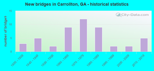
- New bridges - historical statistics
- 31930-1939
- 51940-1949
- 21950-1959
- 91960-1969
- 121970-1979
- 91980-1989
- 21990-1999
- 22000-2009
- 52010-2019
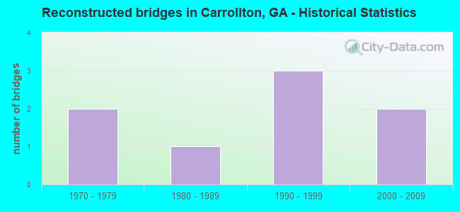
- Reconstructed bridges - Historical Statistics
- 21970-1979
- 11980-1989
- 31990-1999
- 22000-2009
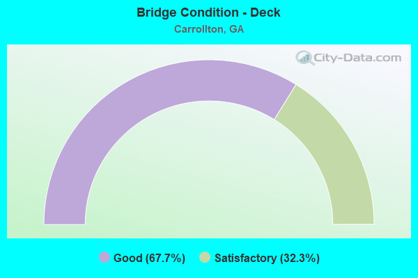
- Bridge Condition - Deck
- 67.7%Good
- 32.3%Satisfactory
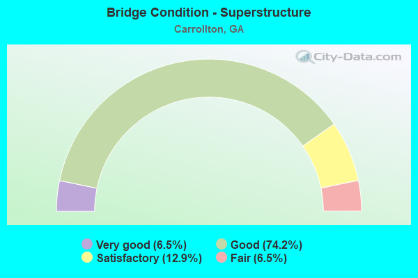
- Bridge Condition - Superstructure
- 6.5%Very good
- 74.2%Good
- 12.9%Satisfactory
- 6.5%Fair
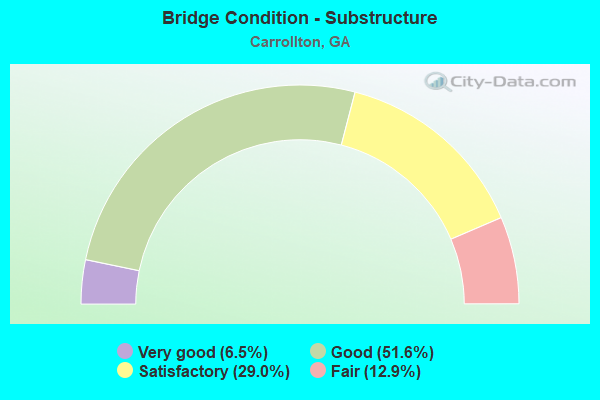
- Bridge Condition - Substructure
- 6.5%Very good
- 51.6%Good
- 29.0%Satisfactory
- 12.9%Fair
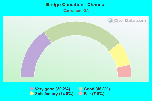
- Bridge Condition - Channel
- 30.2%Very good
- 48.8%Good
- 14.0%Satisfactory
- 7.0%Fair
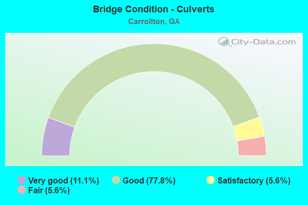
- Bridge Condition - Culverts
- 11.1%Very good
- 77.8%Good
- 5.6%Satisfactory
- 5.6%Fair
Find on map >> Show street view
Structure Number: 450003, Location: IN SOUTH CARROLLTON (Lat: 33.561758, Lng: -85.073197), Route carried "on" structure: US 27, Year Built: 1960, Year Reconstructed: 1996, Status: Open, Structure Length: 0.98m (3.22ft), Average Daily Traffic: 27,100 (year 2011), Truck Traffic: 1%, Average Future Daily Traffic: 40,650 (year 2031), Design Load: H 15, Features Intersected: BUFFALO CREEK
Minimum Vertical Clearance: 30+ m (98+ ft), Kilometerpoint: 17.703, Lanes on structure: 7, Base Highway Network: Yes, Owner: State Highway Agency, Approaching Roadway Width: 29.3m (96.1ft), Skew: 10 degrees, Material/Design: Concrete, Design/Construction: Culvert, Number Of Spans In Main Unit: 3, Length of Maximum Span: 3.0m (9.8ft)
Condition: Channel: Good, Culverts: Good, Operating Rating: 59.8 metric tons, Method Used To Determine Operating Rating: Load Factor (LF), Inventory Rating: 36.2 metric tons, Method Used To Determine Inventory Rating: Load Factor (LF), Structural Evaluation: Better than present minimum criteria, Waterway Adequacy: Superior to present desirable criteria, Approach Roadway Alignment: Equal to present desirable criteria, Designated Inspection Frequency: Every 24 months, Inspection Date: August 2020, Bridge Improvement Cost: $296,000, Roadway Improvement Cost: $30,000, Total Project Cost: $443,000
Find on map >> Show street view
Structure Number: 450004, Location: IN NORTH CARROLLTON (Lat: 33.596961, Lng: -85.079225), Route carried "on" structure: US 27, Year Built: 1941, Year Reconstructed: 1982, Status: Open, Structure Length: 8.05m (26.41ft), Average Daily Traffic: 19,810 (year 2011), Truck Traffic: 1%, Average Future Daily Traffic: 29,715 (year 2031), Design Load: H 15, Features Intersected: LITTLE TALLAPOOSA RIVER
Minimum Vertical Clearance: 30+ m (98+ ft), Kilometerpoint: 20.921, Lanes on structure: 5, Base Highway Network: Yes, Owner: State Highway Agency, Approaching Roadway Width: 20.1m (65.9ft), Material/Design: Steel, Design/Construction: Stringer/Multi-beam, Number Of Spans In Main Unit: 1, Number Of Approach Spans: 7, Length of Maximum Span: 15.5m (50.9ft), Curb or Sidewalk Widths: Left: 1.8m (5.9ft), Right: 1.8m (5.9ft), Curb-To-Curb Width: 20.1m (65.9ft), Out-to-Out Width: 24.5m (80.4ft)
Condition: Deck: Satisfactory, Superstructure: Good, Substructure: Satisfactory, Channel: Very good, Operating Rating: 45.3 metric tons, Method Used To Determine Operating Rating: Load Factor (LF), Inventory Rating: 27.2 metric tons, Method Used To Determine Inventory Rating: Load Factor (LF), Structural Evaluation: Equal to present minimum criteria, Deck Geometry: Somewhat better than minimum adequacy, Waterway Adequacy: Superior to present desirable criteria, Approach Roadway Alignment: Equal to present desirable criteria, Designated Inspection Frequency: Every 24 months, Inspection Date: July 2020, Bridge Improvement Cost: $1,875,000, Roadway Improvement Cost: $188,000, Total Project Cost: $2,813,000, Deck Structure Type: Concrete Cast-file-Place, Wearing Surface/Protective System: Wearing Surface: Bituminous
Find on map >> Show street view
Structure Number: 450005, Location: 3 MI N OF CARROLLTON (Lat: 33.617278, Lng: -85.093658), Route carried "on" structure: US 27, Year Built: 1937, Year Reconstructed: 1991, Status: Open, Structure Length: 0.73m (2.40ft), Average Daily Traffic: 13,450 (year 2011), Truck Traffic: 1%, Average Future Daily Traffic: 20,175 (year 2031), Design Load: H 15, Features Intersected: L. TALLAPOOSA RIVER TRIB
Minimum Vertical Clearance: 30+ m (98+ ft), Kilometerpoint: 24.140, Lanes on structure: 6, Base Highway Network: Yes, Owner: State Highway Agency, Approaching Roadway Width: 20.1m (65.9ft), Skew: 9 degrees, Material/Design: Concrete, Design/Construction: Culvert, Number Of Spans In Main Unit: 3, Length of Maximum Span: 2.1m (6.9ft)
Condition: Channel: Good, Culverts: Good, Operating Rating: 34.4 metric tons, Method Used To Determine Operating Rating: Load Factor (LF), Inventory Rating: 20.8 metric tons, Method Used To Determine Inventory Rating: Load Factor (LF), Structural Evaluation: Somewhat better than minimum adequacy, Waterway Adequacy: Superior to present desirable criteria, Approach Roadway Alignment: Equal to present desirable criteria, Length Of Structure Improvement: 7.16m (23.49ft), Designated Inspection Frequency: Every 24 months, Inspection Date: July 2020, Bridge Improvement Cost: $196,000, Roadway Improvement Cost: $20,000, Total Project Cost: $294,000
Find on map >> Show street view
Structure Number: 450006, Location: 4 MI N OF CARROLLTON (Lat: 33.626417, Lng: -85.106703), Route carried "on" structure: US 27, Year Built: 1941, Year Reconstructed: 1990, Status: Open, Structure Length: 4.57m (14.99ft), Average Daily Traffic: 18,500 (year 2011), Truck Traffic: 8%, Average Future Daily Traffic: 27,750 (year 2031), Design Load: H 15, Features Intersected: BUCK CREEK
Minimum Vertical Clearance: 30+ m (98+ ft), Kilometerpoint: 25.750, Lanes on structure: 4, Base Highway Network: Yes, Owner: State Highway Agency, Approaching Roadway Width: 18.9m (62.0ft), Skew: 20 degrees, Material/Design: Concrete, Design/Construction: Tee Beam, Number Of Spans In Main Unit: 5, Length of Maximum Span: 9.1m (29.9ft), Curb-To-Curb Width: 27.2m (89.2ft), Out-to-Out Width: 28.1m (92.2ft)
Condition: Deck: Good, Superstructure: Satisfactory, Substructure: Satisfactory, Channel: Very good, Operating Rating: 47.1 metric tons, Method Used To Determine Operating Rating: Load Factor (LF), Inventory Rating: 28.1 metric tons, Method Used To Determine Inventory Rating: Load Factor (LF), Structural Evaluation: Equal to present minimum criteria, Deck Geometry: Superior to present desirable criteria, Waterway Adequacy: Superior to present desirable criteria, Approach Roadway Alignment: Equal to present desirable criteria, Designated Inspection Frequency: Every 24 months, Inspection Date: July 2020, Bridge Improvement Cost: $906,000, Roadway Improvement Cost: $91,000, Total Project Cost: $1,359,000, Deck Structure Type: Concrete Cast-file-Place, Wearing Surface/Protective System: Wearing Surface: Bituminous
Find on map >> Show street view
Structure Number: 450025, Location: 3 MI W OF CARROLLTON (Lat: 33.592475, Lng: -85.129675), Route carried "on" structure: State highway 16, Year Built: 1979, Status: Open, Structure Length: 4.88m (16.01ft), Average Daily Traffic: 3,210 (year 2011), Truck Traffic: 1%, Average Future Daily Traffic: 4,815 (year 2031), Design Load: HS 20, Features Intersected: BUCK CREEK
Minimum Vertical Clearance: 30+ m (98+ ft), Kilometerpoint: 16.093, Lanes on structure: 2, Base Highway Network: Yes, Owner: State Highway Agency, Approaching Roadway Width: 7.3m (24.0ft), Skew: 1 degrees, Material/Design: Concrete, Design/Construction: Tee Beam, Number Of Spans In Main Unit: 4, Length of Maximum Span: 12.2m (40.0ft), Curb-To-Curb Width: 13.0m (42.7ft), Out-to-Out Width: 14.0m (45.9ft)
Condition: Deck: Good, Superstructure: Good, Substructure: Good, Channel: Good, Operating Rating: 38.1 metric tons, Method Used To Determine Operating Rating: Load Factor (LF), Inventory Rating: 22.6 metric tons, Method Used To Determine Inventory Rating: Load Factor (LF), Structural Evaluation: Equal to present minimum criteria, Deck Geometry: Equal to present minimum criteria, Waterway Adequacy: Superior to present desirable criteria, Approach Roadway Alignment: Equal to present minimum criteria, Designated Inspection Frequency: Every 24 months, Inspection Date: September 2020, Bridge Improvement Cost: $625,000, Roadway Improvement Cost: $63,000, Total Project Cost: $938,000, Deck Structure Type: Concrete Cast-file-Place
Find on map >> Show street view
Structure Number: 450026, Location: 2 MI W OF CARROLLTON (Lat: 33.588508, Lng: -85.106047), Route carried "on" structure: State highway 16, Year Built: 1960, Status: Open, Structure Length: 4.66m (15.29ft), Average Daily Traffic: 4,130 (year 2011), Truck Traffic: 4%, Average Future Daily Traffic: 6,195 (year 2031), Design Load: H 20, Features Intersected: LITTLE TALLAPOOSA RIVER
Minimum Vertical Clearance: 30+ m (98+ ft), Kilometerpoint: 17.703, Lanes on structure: 2, Base Highway Network: Yes, Owner: State Highway Agency, Approaching Roadway Width: 7.3m (24.0ft), Material/Design: Steel, Design/Construction: Stringer/Multi-beam, Number Of Spans In Main Unit: 3, Length of Maximum Span: 15.5m (50.9ft), Curb or Sidewalk Widths: Left: 1.5m (4.9ft), Right: 1.5m (4.9ft), Curb-To-Curb Width: 8.5m (27.9ft), Out-to-Out Width: 12.3m (40.4ft)
Condition: Deck: Good, Superstructure: Good, Substructure: Good, Channel: Good, Operating Rating: 30.8 metric tons, Method Used To Determine Operating Rating: Load Factor (LF), Inventory Rating: 18.1 metric tons, Method Used To Determine Inventory Rating: Load Factor (LF), Structural Evaluation: Somewhat better than minimum adequacy, Deck Geometry: Meets minimum limits, Waterway Adequacy: Superior to present desirable criteria, Approach Roadway Alignment: Equal to present desirable criteria, Length Of Structure Improvement: 11.09m (36.38ft), Designated Inspection Frequency: Every 24 months, Inspection Date: September 2020, Bridge Improvement Cost: $598,000, Roadway Improvement Cost: $60,000, Total Project Cost: $897,000, Deck Structure Type: Concrete Cast-file-Place, Wearing Surface/Protective System: Wearing Surface: Bituminous
Find on map >> Show street view
Structure Number: 450027, Location: IN SOUTH CARROLLTON (Lat: 33.557869, Lng: -85.064358), Route carried "on" structure: Alternate US 27, Year Built: 1977, Status: Open, Structure Length: 8.53m (27.99ft), Average Daily Traffic: 26,510 (year 2011), Truck Traffic: 1%, Average Future Daily Traffic: 39,765 (year 2031), Design Load: HS 20+Mod, Features Intersected: NS RAILROAD
Minimum Vertical Clearance: 30+ m (98+ ft), Kilometerpoint: 24.140, Lanes on structure: 2, Base Highway Network: Yes, Owner: State Highway Agency, Approaching Roadway Width: 11.6m (38.1ft), Skew: 13 degrees, Material/Design: Steel, Design/Construction: Stringer/Multi-beam, Number Of Spans In Main Unit: 4, Length of Maximum Span: 29.6m (97.1ft), Curb-To-Curb Width: 12.8m (42.0ft), Out-to-Out Width: 13.6m (44.6ft)
Condition: Deck: Satisfactory, Superstructure: Good, Substructure: Satisfactory, Operating Rating: 41.7 metric tons, Method Used To Determine Operating Rating: Load Factor (LF), Inventory Rating: 24.4 metric tons, Method Used To Determine Inventory Rating: Load Factor (LF), Structural Evaluation: Equal to present minimum criteria, Deck Geometry: Equal to present desirable criteria, Underclear: Equal to present desirable criteria, Approach Roadway Alignment: Equal to present desirable criteria, Designated Inspection Frequency: Every 24 months, Inspection Date: August 2020, Bridge Improvement Cost: $1,094,000, Roadway Improvement Cost: $109,000, Total Project Cost: $1,641,000, Deck Structure Type: Concrete Cast-file-Place
Find on map >> Show street view
Structure Number: 450028, Location: IN SOUTH CARROLLTON (Lat: 33.558100, Lng: -85.064558), Route carried "on" structure: Alternate US 27, Year Built: 1977, Status: Open, Structure Length: 8.53m (27.99ft), Average Daily Traffic: 26,510 (year 2011), Truck Traffic: 1%, Average Future Daily Traffic: 39,765 (year 2031), Design Load: HS 20+Mod, Features Intersected: NS RAILROAD
Minimum Vertical Clearance: 30+ m (98+ ft), Kilometerpoint: 24.140, Lanes on structure: 2, Base Highway Network: Yes, Owner: State Highway Agency, Approaching Roadway Width: 11.6m (38.1ft), Skew: 13 degrees, Material/Design: Steel, Design/Construction: Stringer/Multi-beam, Number Of Spans In Main Unit: 4, Length of Maximum Span: 29.6m (97.1ft), Curb-To-Curb Width: 12.8m (42.0ft), Out-to-Out Width: 13.6m (44.6ft)
Condition: Deck: Satisfactory, Superstructure: Good, Substructure: Satisfactory, Operating Rating: 37.1 metric tons, Method Used To Determine Operating Rating: Load Factor (LF), Inventory Rating: 21.7 metric tons, Method Used To Determine Inventory Rating: Load Factor (LF), Structural Evaluation: Somewhat better than minimum adequacy, Deck Geometry: Equal to present desirable criteria, Underclear: Better than present minimum criteria, Approach Roadway Alignment: Equal to present desirable criteria, Designated Inspection Frequency: Every 24 months, Inspection Date: August 2020, Bridge Improvement Cost: $1,094,000, Roadway Improvement Cost: $109,000, Total Project Cost: $1,641,000, Deck Structure Type: Concrete Cast-file-Place
Find on map >> Show street view
Structure Number: 450037, Location: 4 MI N OF CARROLLTON (Lat: 33.638800, Lng: -85.054389), Route carried "on" structure: State highway 113, Year Built: 1982, Status: Open, Structure Length: 1.31m (4.30ft), Average Daily Traffic: 6,170 (year 2011), Truck Traffic: 1%, Average Future Daily Traffic: 9,255 (year 2031), Design Load: HS 20+Mod, Features Intersected: SHARPE CREEK
Minimum Vertical Clearance: 30+ m (98+ ft), Kilometerpoint: 4.828, Lanes on structure: 2, Base Highway Network: Yes, Owner: State Highway Agency, Approaching Roadway Width: 8.5m (27.9ft), Material/Design: Concrete, Design/Construction: Culvert, Number Of Spans In Main Unit: 4, Length of Maximum Span: 3.0m (9.8ft)
Condition: Channel: Good, Culverts: Good, Operating Rating: 59.8 metric tons, Method Used To Determine Operating Rating: Load Factor (LF), Inventory Rating: 36.2 metric tons, Method Used To Determine Inventory Rating: Load Factor (LF), Structural Evaluation: Better than present minimum criteria, Waterway Adequacy: Superior to present desirable criteria, Approach Roadway Alignment: Equal to present desirable criteria, Designated Inspection Frequency: Every 24 months, Inspection Date: July 2020, Bridge Improvement Cost: $168,000, Roadway Improvement Cost: $17,000, Total Project Cost: $252,000
Find on map >> Show street view
Structure Number: 450044, Location: 5.5 MI W OF CARROLLTON (Lat: 33.560058, Lng: -85.162897), Route carried "on" structure: State highway 166, Year Built: 1933, Status: Open, Structure Length: 1.04m (3.41ft), Average Daily Traffic: 9,770 (year 2011), Truck Traffic: 5%, Average Future Daily Traffic: 14,655 (year 2031), Design Load: H 15, Features Intersected: GARRETT HILL BRANCH
Minimum Vertical Clearance: 30+ m (98+ ft), Kilometerpoint: 16.093, Lanes on structure: 2, Base Highway Network: Yes, Owner: State Highway Agency, Approaching Roadway Width: 9.8m (32.2ft), Material/Design: Concrete, Design/Construction: Culvert, Number Of Spans In Main Unit: 3, Length of Maximum Span: 3.0m (9.8ft)
Condition: Channel: Satisfactory, Culverts: Good, Operating Rating: 41.7 metric tons, Method Used To Determine Operating Rating: Load Factor (LF), Inventory Rating: 24.4 metric tons, Method Used To Determine Inventory Rating: Load Factor (LF), Structural Evaluation: Equal to present minimum criteria, Waterway Adequacy: Superior to present desirable criteria, Approach Roadway Alignment: Equal to present desirable criteria, Designated Inspection Frequency: Every 24 months, Inspection Date: August 2020, Bridge Improvement Cost: $133,000, Roadway Improvement Cost: $13,000, Total Project Cost: $199,000
Find on map >> Show street view
Structure Number: 450045, Location: 4.5 MILES WEST OF CARROLL (Lat: 33.561275, Lng: -85.147986), Route carried "on" structure: State highway 166, Year Built: 1971, Status: Open, Structure Length: 12.19m (39.99ft), Average Daily Traffic: 9,770 (year 2011), Truck Traffic: 5%, Average Future Daily Traffic: 14,655 (year 2031), Design Load: HS 20, Features Intersected: LITTLE TALLAPOOSA RIVER
Minimum Vertical Clearance: 30+ m (98+ ft), Kilometerpoint: 17.703, Lanes on structure: 2, Base Highway Network: Yes, Owner: State Highway Agency, Approaching Roadway Width: 9.8m (32.2ft), Skew: 2 degrees, Material/Design: Concrete, Design/Construction: Tee Beam, Number Of Spans In Main Unit: 10, Length of Maximum Span: 12.2m (40.0ft), Curb or Sidewalk Widths: Left: 0.2m (0.7ft), Right: 0.2m (0.7ft), Curb-To-Curb Width: 14.3m (46.9ft), Out-to-Out Width: 15.3m (50.2ft)
Condition: Deck: Good, Superstructure: Good, Substructure: Good, Channel: Satisfactory, Operating Rating: 46.2 metric tons, Method Used To Determine Operating Rating: Allowable Stress (AS), Inventory Rating: 32.6 metric tons, Method Used To Determine Inventory Rating: Allowable Stress (AS), Structural Evaluation: Better than present minimum criteria, Deck Geometry: Superior to present desirable criteria, Waterway Adequacy: Equal to present minimum criteria, Approach Roadway Alignment: Equal to present desirable criteria, Designated Inspection Frequency: Every 24 months, Underwater Inspection Frequency: Every 60 months, Other Special Inspection Frequency: Every 12 months, Inspection Date: August 2020, Underwater Inspection Date: April 2020, Other Special Inspection Date: August 2021, Bridge Improvement Cost: $1,563,000, Roadway Improvement Cost: $156,000, Total Project Cost: $2,344,000, Deck Structure Type: Concrete Cast-file-Place
Find on map >> Show street view
Structure Number: 450046, Location: 2 MI SW OF CARROLLTON (Lat: 33.557228, Lng: -85.094539), Route carried "on" structure: State highway 166, Year Built: 1979, Status: Open, Structure Length: 0.88m (2.89ft), Average Daily Traffic: 19,270 (year 2011), Truck Traffic: 1%, Average Future Daily Traffic: 28,905 (year 2031), Design Load: HS 20+Mod, Features Intersected: BUFFALO CREEK
Minimum Vertical Clearance: 30+ m (98+ ft), Kilometerpoint: 22.531, Lanes on structure: 4, Base Highway Network: Yes, Owner: State Highway Agency, Approaching Roadway Width: 22.6m (74.1ft), Skew: 10 degrees, Material/Design: Concrete, Design/Construction: Culvert, Number Of Spans In Main Unit: 3, Length of Maximum Span: 2.7m (8.9ft)
Condition: Channel: Good, Culverts: Good, Structural Evaluation: Better than present minimum criteria, Waterway Adequacy: Superior to present desirable criteria, Approach Roadway Alignment: Equal to present desirable criteria, Designated Inspection Frequency: Every 24 months, Inspection Date: August 2020, Bridge Improvement Cost: $175,000, Roadway Improvement Cost: $18,000, Total Project Cost: $263,000
Find on map >> Show street view
Structure Number: 450047, Location: 2 MI E OF CARROLLTON (Lat: 33.588989, Lng: -85.041389), Route carried "on" structure: State highway 166, Year Built: 1977, Year Reconstructed: 1995, Status: Open, Structure Length: 0.64m (2.10ft), Average Daily Traffic: 23,350 (year 2011), Truck Traffic: 1%, Average Future Daily Traffic: 35,025 (year 2031), Design Load: HS 20+Mod, Features Intersected: CURTIS CREEK
Minimum Vertical Clearance: 30+ m (98+ ft), Kilometerpoint: 30.578, Lanes on structure: 4, Base Highway Network: Yes, Owner: State Highway Agency, Approaching Roadway Width: 22.6m (74.1ft), Skew: 11 degrees, Material/Design: Concrete, Design/Construction: Culvert, Number Of Spans In Main Unit: 2, Length of Maximum Span: 3.0m (9.8ft)
Condition: Channel: Good, Culverts: Good, Structural Evaluation: Better than present minimum criteria, Waterway Adequacy: Superior to present desirable criteria, Approach Roadway Alignment: Equal to present desirable criteria, Designated Inspection Frequency: Every 24 months, Underwater Inspection Frequency: Every 60 months, Inspection Date: July 2020, Underwater Inspection Date: August 2020, Bridge Improvement Cost: $127,000, Roadway Improvement Cost: $13,000, Total Project Cost: $190,000
Find on map >> Show street view
Structure Number: 450048, Location: 6.5 MI E OF CARROLLTON (Lat: 33.611600, Lng: -84.968900), Route carried "on" structure: State highway 166, Year Built: 1954, Status: Open, Structure Length: 0.73m (2.40ft), Average Daily Traffic: 6,220 (year 2011), Truck Traffic: 5%, Average Future Daily Traffic: 9,330 (year 2031), Design Load: H 15, Features Intersected: SNAKE CREEK
Minimum Vertical Clearance: 30+ m (98+ ft), Kilometerpoint: 38.624, Lanes on structure: 2, Base Highway Network: Yes, Owner: State Highway Agency, Approaching Roadway Width: 8.5m (27.9ft), Skew: 3 degrees, Material/Design: Concrete, Design/Construction: Culvert, Number Of Spans In Main Unit: 2, Length of Maximum Span: 3.7m (12.1ft)
Condition: Channel: Good, Culverts: Satisfactory, Inventory Rating: 76.2 metric tons, Method Used To Determine Inventory Rating: Load Factor (LF), Structural Evaluation: Equal to present minimum criteria, Waterway Adequacy: Superior to present desirable criteria, Approach Roadway Alignment: Equal to present desirable criteria, Designated Inspection Frequency: Every 24 months, Inspection Date: September 2020, Bridge Improvement Cost: $94,000, Roadway Improvement Cost: $9,000, Total Project Cost: $141,000
Find on map >> Show street view
Structure Number: 450065, Location: IN NW CARROLLTON (Lat: 33.594294, Lng: -85.088072), Route carried "on" structure: City street 802, Year Built: 1971, Status: Open, Structure Length: 5.49m (18.01ft), Average Daily Traffic: 3,440 (year 2011), Truck Traffic: 1%, Average Future Daily Traffic: 5,160 (year 2031), Design Load: HS 20, Features Intersected: LITTLE TALLAPOOSA RIVER, Facility Carried by Structure: KINGS BRIDGE ROAD
Minimum Vertical Clearance: 30+ m (98+ ft), Kilometerpoint: 4.828, Lanes on structure: 2, Base Highway Network: Yes, Owner: City or Municipal Highway Agency, Approaching Roadway Width: 7.3m (24.0ft), Material/Design: Steel, Design/Construction: Stringer/Multi-beam, Number Of Spans In Main Unit: 1, Number Of Approach Spans: 3, Length of Maximum Span: 21.9m (71.9ft), Curb or Sidewalk Widths: Left: 0.2m (0.7ft), Right: 0.2m (0.7ft), Curb-To-Curb Width: 11.8m (38.7ft), Out-to-Out Width: 12.9m (42.3ft)
Condition: Deck: Satisfactory, Superstructure: Good, Substructure: Satisfactory, Channel: Very good, Operating Rating: 29.9 metric tons, Method Used To Determine Operating Rating: Load Factor (LF), Inventory Rating: 18.1 metric tons, Method Used To Determine Inventory Rating: Field evaluation and documented engineering judgment, Structural Evaluation: Somewhat better than minimum adequacy, Deck Geometry: Somewhat better than minimum adequacy, Waterway Adequacy: Superior to present desirable criteria, Approach Roadway Alignment: Equal to present desirable criteria, Designated Inspection Frequency: Every 24 months, Inspection Date: July 2020, Bridge Improvement Cost: $703,000, Roadway Improvement Cost: $70,000, Total Project Cost: $1,055,000, Deck Structure Type: Concrete Cast-file-Place
Find on map >> Show street view
Structure Number: 450066, Location: IN WEST CARROLLTON (Lat: 33.589719, Lng: -85.099019), Route carried "on" structure: City street 803, Year Built: 1974, Status: Open, Structure Length: 8.66m (28.41ft), Average Daily Traffic: 8,060 (year 2012), Truck Traffic: 1%, Average Future Daily Traffic: 12,090 (year 2032), Design Load: HS 15, Features Intersected: LITTLE TALLAPOOSA RIVER, Facility Carried by Structure: COLUMBIA DRIVE
Minimum Vertical Clearance: 30+ m (98+ ft), Kilometerpoint: 1.609, Lanes on structure: 2, Base Highway Network: Yes, Owner: City or Municipal Highway Agency, Approaching Roadway Width: 7.3m (24.0ft), Skew: 4 degrees, Material/Design: Steel, Design/Construction: Stringer/Multi-beam, Number Of Spans In Main Unit: 4, Length of Maximum Span: 21.6m (70.9ft), Curb or Sidewalk Widths: Left: 0.2m (0.7ft), Right: 0.2m (0.7ft), Curb-To-Curb Width: 14.3m (46.9ft), Out-to-Out Width: 16.0m (52.5ft)
Condition: Deck: Good, Superstructure: Good, Substructure: Good, Channel: Very good, Operating Rating: 55.3 metric tons, Method Used To Determine Operating Rating: Load Factor (LF), Inventory Rating: 32.6 metric tons, Method Used To Determine Inventory Rating: Load Factor (LF), Structural Evaluation: Better than present minimum criteria, Deck Geometry: Superior to present desirable criteria, Waterway Adequacy: Equal to present desirable criteria, Approach Roadway Alignment: Equal to present desirable criteria, Designated Inspection Frequency: Every 24 months, Inspection Date: September 2020, Bridge Improvement Cost: $1,110,000, Roadway Improvement Cost: $111,000, Total Project Cost: $1,664,000, Deck Structure Type: Concrete Cast-file-Place
Find on map >> Show street view
Structure Number: 450067, Location: IN EAST CARROLLTON (Lat: 33.591119, Lng: -85.047619), Route carried "on" structure: City street 804, Year Built: 1931, Year Reconstructed: 1981, Status: Open, Structure Length: 1.07m (3.51ft), Average Daily Traffic: 18,690 (year 2011), Truck Traffic: 1%, Average Future Daily Traffic: 28,035 (year 2031), Design Load: H 15, Features Intersected: LAKE CARROLL, Facility Carried by Structure: BANKHEAD HIGHWAY
Minimum Vertical Clearance: 30+ m (98+ ft), Kilometerpoint: 8.047, Lanes on structure: 5, Base Highway Network: Yes, Owner: City or Municipal Highway Agency, Approaching Roadway Width: 19.5m (64.0ft), Material/Design: Concrete, Design/Construction: Tee Beam, Number Of Spans In Main Unit: 1, Length of Maximum Span: 10.7m (35.1ft), Curb or Sidewalk Widths: Left: 1.8m (5.9ft), Right: 1.8m (5.9ft), Curb-To-Curb Width: 19.7m (64.6ft), Out-to-Out Width: 24.2m (79.4ft)
Condition: Deck: Good, Superstructure: Good, Substructure: Good, Channel: Very good, Operating Rating: 46.2 metric tons, Method Used To Determine Operating Rating: Load Factor (LF), Inventory Rating: 28.1 metric tons, Method Used To Determine Inventory Rating: Load Factor (LF), Structural Evaluation: Better than present minimum criteria, Deck Geometry: Meets minimum limits, Waterway Adequacy: Equal to present minimum criteria, Approach Roadway Alignment: Equal to present desirable criteria, Designated Inspection Frequency: Every 24 months, Underwater Inspection Frequency: Every 60 months, Inspection Date: August 2020, Underwater Inspection Date: April 2020, Bridge Improvement Cost: $249,000, Roadway Improvement Cost: $25,000, Total Project Cost: $373,000, Deck Structure Type: Concrete Cast-file-Place, Wearing Surface/Protective System: Wearing Surface: Bituminous
Find on map >> Show street view
Structure Number: 450068, Location: 2.7 MILES WEST OF SR 166 (Lat: 33.582889, Lng: -85.128747), Route carried "on" structure: City street 805, Year Built: 1979, Status: Posted for load, Structure Length: 4.27m (14.01ft), Average Daily Traffic: 2,440 (year 2011), Truck Traffic: 1%, Average Future Daily Traffic: 3,660 (year 2031), Design Load: HS 15, Features Intersected: BUCK CREEK, Facility Carried by Structure: LOVVORN ROAD
Minimum Vertical Clearance: 30+ m (98+ ft), Kilometerpoint: 1.609, Lanes on structure: 2, Base Highway Network: Yes, Owner: County Highway Agency, Approaching Roadway Width: 6.1m (20.0ft), Material/Design: Concrete, Design/Construction: Slab, Number Of Spans In Main Unit: 7, Length of Maximum Span: 6.1m (20.0ft), Curb-To-Curb Width: 8.8m (28.9ft), Out-to-Out Width: 9.8m (32.2ft)
Condition: Deck: Good, Superstructure: Good, Substructure: Satisfactory, Channel: Good, Operating Rating: 31.7 metric tons, Method Used To Determine Operating Rating: Load Factor (LF), Inventory Rating: 19.0 metric tons, Method Used To Determine Inventory Rating: Load Factor (LF), Structural Evaluation: Somewhat better than minimum adequacy, Deck Geometry: Meets minimum limits, Waterway Adequacy: Superior to present desirable criteria, Approach Roadway Alignment: Equal to present desirable criteria, Bridge Posting: Required (Relationship of Operating Rating to Maximum Legal Load: 0.1 - 9.9% below), Designated Inspection Frequency: Every 24 months, Inspection Date: August 2020, Bridge Improvement Cost: $547,000, Roadway Improvement Cost: $55,000, Total Project Cost: $821,000, Deck Structure Type: Concrete Precast Panels, Wearing Surface/Protective System: Wearing Surface: Bituminous
Find on map >> Show street view
Structure Number: 450069, Location: IN WEST CARROLLTON (Lat: 33.580269, Lng: -85.101269), Route carried "on" structure: City street 805, Year Built: 1981, Status: Open, Structure Length: 6.10m (20.01ft), Average Daily Traffic: 2,440 (year 2011), Truck Traffic: 1%, Average Future Daily Traffic: 3,660 (year 2031), Design Load: HS 15, Features Intersected: LITTLE TALLAPOOSA RIVER, Facility Carried by Structure: LOVVORN ROAD
Minimum Vertical Clearance: 30+ m (98+ ft), Kilometerpoint: 3.219, Lanes on structure: 2, Base Highway Network: Yes, Owner: City or Municipal Highway Agency, Approaching Roadway Width: 6.1m (20.0ft), Material/Design: Concrete, Design/Construction: Tee Beam, Number Of Spans In Main Unit: 5, Length of Maximum Span: 12.2m (40.0ft), Curb-To-Curb Width: 13.4m (44.0ft), Out-to-Out Width: 14.4m (47.2ft)
Condition: Deck: Good, Superstructure: Good, Substructure: Good, Channel: Good, Operating Rating: 60.7 metric tons, Method Used To Determine Operating Rating: Load Factor (LF), Inventory Rating: 36.2 metric tons, Method Used To Determine Inventory Rating: Load Factor (LF), Structural Evaluation: Better than present minimum criteria, Deck Geometry: Better than present minimum criteria, Waterway Adequacy: Superior to present desirable criteria, Approach Roadway Alignment: Equal to present desirable criteria, Designated Inspection Frequency: Every 24 months, Inspection Date: September 2020, Bridge Improvement Cost: $781,000, Roadway Improvement Cost: $78,000, Total Project Cost: $1,172,000, Deck Structure Type: Concrete Cast-file-Place
Find on map >> Show street view
Structure Number: 45007, Location: IN CENTRAL CARROLLTON (Lat: 33.575089, Lng: -85.079028), Route carried "on" structure: City street 808, Year Built: 1961, Status: Open, Structure Length: 5.27m (17.29ft), Average Daily Traffic: 10,910 (year 2011), Truck Traffic: 1%, Average Future Daily Traffic: 16,365 (year 2031), Design Load: HS 20, Features Intersected: SR 1 (US 27), Facility Carried by Structure: SOUTH STREET
Minimum Vertical Clearance: 30+ m (98+ ft), Kilometerpoint: 3.219, Lanes on structure: 4, Lanes under structure: 6, Base Highway Network: Yes, Owner: State Highway Agency, Approaching Roadway Width: 13.4m (44.0ft), Material/Design: Steel, Design/Construction: Stringer/Multi-beam, Number Of Spans In Main Unit: 4, Length of Maximum Span: 15.5m (50.9ft), Curb or Sidewalk Widths: Left: 1.7m (5.6ft), Right: 1.7m (5.6ft), Curb-To-Curb Width: 13.4m (44.0ft), Out-to-Out Width: 17.6m (57.7ft)
Condition: Deck: Good, Superstructure: Good, Substructure: Good, Operating Rating: 31.7 metric tons, Method Used To Determine Operating Rating: Load Factor (LF), Inventory Rating: 19.0 metric tons, Method Used To Determine Inventory Rating: Load Factor (LF), Structural Evaluation: Meets minimum limits, Deck Geometry: High priority of replacement, Underclear: Meets minimum limits, Approach Roadway Alignment: Equal to present desirable criteria, Designated Inspection Frequency: Every 24 months, Inspection Date: August 2020, Bridge Improvement Cost: $1,045,000, Roadway Improvement Cost: $104,000, Total Project Cost: $1,567,000, Deck Structure Type: Concrete Cast-file-Place
Find on map >> Show street view
Structure Number: 450071, Location: IN SW CARROLLTON (Lat: 33.563744, Lng: -85.093167), Route carried "on" structure: City street 811, Year Built: 1948, Status: Open, Structure Length: 1.13m (3.71ft), Average Daily Traffic: 5,540 (year 2011), Truck Traffic: 1%, Average Future Daily Traffic: 8,310 (year 2031), Design Load: H 15, Features Intersected: BUFFALO CREEK, Facility Carried by Structure: HAYS MILL ROAD
Minimum Vertical Clearance: 30+ m (98+ ft), Kilometerpoint: 1.609, Lanes on structure: 2, Base Highway Network: Yes, Owner: City or Municipal Highway Agency, Approaching Roadway Width: 6.1m (20.0ft), Skew: 3 degrees, Material/Design: Concrete, Design/Construction: Culvert, Number Of Spans In Main Unit: 3, Length of Maximum Span: 3.7m (12.1ft), Curb or Sidewalk Widths: Left: 1.8m (5.9ft), Right: 0.0m
Condition: Channel: Good, Culverts: Good, Operating Rating: 41.7 metric tons, Method Used To Determine Operating Rating: Field evaluation and documented engineering judgment, Inventory Rating: 24.4 metric tons, Method Used To Determine Inventory Rating: Field evaluation and documented engineering judgment, Structural Evaluation: Equal to present minimum criteria, Waterway Adequacy: Superior to present desirable criteria, Approach Roadway Alignment: Equal to present minimum criteria, Designated Inspection Frequency: Every 24 months, Inspection Date: August 2020, Bridge Improvement Cost: $145,000, Roadway Improvement Cost: $14,000, Total Project Cost: $217,000
Find on map >> Show street view
Structure Number: 450072, Location: 2 MI E OF CARROLLTON (Lat: 33.576981, Lng: -85.041681), Route carried "on" structure: City street 812, Year Built: 1977, Status: Open, Structure Length: 9.02m (29.59ft), Average Daily Traffic: 1,890 (year 2011), Truck Traffic: 1%, Average Future Daily Traffic: 2,835 (year 2031), Design Load: HS 20+Mod, Features Intersected: SR 166 SOUTH BYPASS, Facility Carried by Structure: HORSELY MILL ROAD
Minimum Vertical Clearance: 30+ m (98+ ft), Kilometerpoint: 3.219, Lanes on structure: 2, Lanes under structure: 4, Base Highway Network: Yes, Owner: State Highway Agency, Approaching Roadway Width: 7.3m (24.0ft), Skew: 1 degrees, Material/Design: Steel continuous, Design/Construction: Stringer/Multi-beam, Number Of Spans In Main Unit: 4, Length of Maximum Span: 27.4m (89.9ft), Curb-To-Curb Width: 14.6m (47.9ft), Out-to-Out Width: 15.4m (50.5ft)
Condition: Deck: Good, Superstructure: Good, Substructure: Good, Operating Rating: 52.6 metric tons, Method Used To Determine Operating Rating: Load Factor (LF), Inventory Rating: 31.7 metric tons, Method Used To Determine Inventory Rating: Load Factor (LF), Structural Evaluation: Better than present minimum criteria, Deck Geometry: Superior to present desirable criteria, Underclear: Better than present minimum criteria, Approach Roadway Alignment: Equal to present desirable criteria, Designated Inspection Frequency: Every 24 months, Inspection Date: August 2020, Bridge Improvement Cost: $1,157,000, Roadway Improvement Cost: $116,000, Total Project Cost: $1,735,000, Deck Structure Type: Concrete Cast-file-Place
Find on map >> Show street view
Structure Number: 450078, Location: 6.5 MI NE OF CARROLLTON (Lat: 33.663186, Lng: -85.013750), Route carried "on" structure: County highway 1325, Year Built: 1963, Status: Posted for load, Structure Length: 2.74m (8.99ft), Average Daily Traffic: 1,730 (year 2011), Truck Traffic: 1%, Average Future Daily Traffic: 2,595 (year 2031), Design Load: H 15, Features Intersected: HARMONY CREEK, Facility Carried by Structure: SHADY GROVE ROAD
Minimum Vertical Clearance: 30+ m (98+ ft), Kilometerpoint: 6.437, Lanes on structure: 2, Base Highway Network: Yes, Owner: County Highway Agency, Approaching Roadway Width: 7.3m (24.0ft), Material/Design: Concrete, Design/Construction: Tee Beam, Number Of Spans In Main Unit: 3, Length of Maximum Span: 12.2m (40.0ft), Curb or Sidewalk Widths: Left: 0.6m (2.0ft), Right: 0.6m (2.0ft), Curb-To-Curb Width: 7.9m (25.9ft), Out-to-Out Width: 9.8m (32.2ft)
Condition: Deck: Satisfactory, Superstructure: Good, Substructure: Satisfactory, Channel: Fair, Operating Rating: 21.7 metric tons, Method Used To Determine Operating Rating: Load Factor (LF), Inventory Rating: 12.7 metric tons, Method Used To Determine Inventory Rating: Load Factor (LF), Structural Evaluation: Meets minimum limits, Deck Geometry: Meets minimum limits, Waterway Adequacy: Superior to present desirable criteria, Approach Roadway Alignment: Equal to present desirable criteria, Bridge Posting: Required (Relationship of Operating Rating to Maximum Legal Load: 30.0 - 39.9% below), Length Of Structure Improvement: 9.24m (30.31ft), Designated Inspection Frequency: Every 24 months, Inspection Date: July 2020, Bridge Improvement Cost: $352,000, Roadway Improvement Cost: $35,000, Total Project Cost: $527,000, Deck Structure Type: Concrete Cast-file-Place
Find on map >> Show street view
Structure Number: 450093, Location: 5.5 MI E OF BOWDON (Lat: 33.534778, Lng: -85.159978), Route carried "on" structure: County highway 2820, Year Built: 1972, Status: Open, Structure Length: 4.66m (15.29ft), Average Daily Traffic: 600 (year 2011), Truck Traffic: 1%, Average Future Daily Traffic: 900 (year 2031), Features Intersected: LITTLE TALLAPOOSA RIVER, Facility Carried by Structure: SALEM CHURCH ROAD
Minimum Vertical Clearance: 30+ m (98+ ft), Kilometerpoint: 1.609, Lanes on structure: 2, Base Highway Network: Yes, Owner: County Highway Agency, Approaching Roadway Width: 6.1m (20.0ft), Material/Design: Steel continuous, Design/Construction: Stringer/Multi-beam, Number Of Spans In Main Unit: 5, Length of Maximum Span: 14.3m (46.9ft), Curb-To-Curb Width: 6.9m (22.6ft), Out-to-Out Width: 7.3m (24.0ft)
Condition: Deck: Satisfactory, Superstructure: Satisfactory, Substructure: Satisfactory, Channel: Satisfactory, Operating Rating: 39.0 metric tons, Method Used To Determine Operating Rating: Load Factor (LF), Inventory Rating: 22.6 metric tons, Method Used To Determine Inventory Rating: Load Factor (LF), Structural Evaluation: Equal to present minimum criteria, Deck Geometry: Meets minimum limits, Waterway Adequacy: Equal to present desirable criteria, Approach Roadway Alignment: Equal to present desirable criteria, Length Of Structure Improvement: 10.91m (35.79ft), Designated Inspection Frequency: Every 24 months, Underwater Inspection Frequency: Every 60 months, Inspection Date: August 2020, Underwater Inspection Date: April 2020, Bridge Improvement Cost: $598,000, Roadway Improvement Cost: $60,000, Total Project Cost: $897,000, Deck Structure Type: Concrete Cast-file-Place, Wearing Surface/Protective System: Wearing Surface: Bituminous
Find on map >> Show street view
Structure Number: 455005, Location: 2.5 MI S OF CARROLLTON (Lat: 33.548394, Lng: -85.094269), Route carried "on" structure: County highway 27, Year Built: 1960, Status: Posted for load, Structure Length: 1.16m (3.81ft), Average Daily Traffic: 1,096 (year 2011), Truck Traffic: 1%, Average Future Daily Traffic: 1,644 (year 2031), Features Intersected: BUFFALO CREEK, Facility Carried by Structure: MARTIN-CEMETERY RD
Minimum Vertical Clearance: 30+ m (98+ ft), Kilometerpoint: 0.000, Lanes on structure: 2, Base Highway Network: Yes, Owner: County Highway Agency, Approaching Roadway Width: 6.4m (21.0ft), Material/Design: Steel continuous, Design/Construction: Stringer/Multi-beam, Number Of Spans In Main Unit: 2, Length of Maximum Span: 5.8m (19.0ft), Curb-To-Curb Width: 7.6m (24.9ft), Out-to-Out Width: 8.0m (26.2ft)
Condition: Deck: Satisfactory, Superstructure: Fair, Substructure: Fair, Channel: Satisfactory, Operating Rating: 55.3 metric tons, Method Used To Determine Operating Rating: Load Factor (LF), Inventory Rating: 32.6 metric tons, Method Used To Determine Inventory Rating: Load Factor (LF), Structural Evaluation: Somewhat better than minimum adequacy, Deck Geometry: Meets minimum limits, Waterway Adequacy: Superior to present desirable criteria, Approach Roadway Alignment: Somewhat better than minimum adequacy, Designated Inspection Frequency: Every 24 months, Inspection Date: August 2020, Bridge Improvement Cost: $148,000, Roadway Improvement Cost: $15,000, Total Project Cost: $223,000, Deck Structure Type: Concrete Cast-file-Place, Wearing Surface/Protective System: Wearing Surface: Bituminous
Find on map >> Show street view
Structure Number: 455006, Location: 3.5 MI SW OF CARROLLTON (Lat: 33.540689, Lng: -85.108744), Route carried "on" structure: County highway 31, Year Built: 1960, Status: Posted for load, Structure Length: 2.16m (7.09ft), Average Daily Traffic: 1,096 (year 2011), Truck Traffic: 1%, Average Future Daily Traffic: 1,644 (year 2031), Features Intersected: BUFFALO CREEK, Facility Carried by Structure: BUFFALO CREEK ROAD
Minimum Vertical Clearance: 30+ m (98+ ft), Kilometerpoint: 1.609, Lanes on structure: 2, Base Highway Network: Yes, Owner: County Highway Agency, Approaching Roadway Width: 5.5m (18.0ft), Material/Design: Steel continuous, Design/Construction: Stringer/Multi-beam, Number Of Spans In Main Unit: 3, Length of Maximum Span: 7.9m (25.9ft), Curb-To-Curb Width: 6.8m (22.3ft), Out-to-Out Width: 7.3m (24.0ft)
Condition: Deck: Satisfactory, Superstructure: Fair, Substructure: Fair, Channel: Fair, Operating Rating: 39.0 metric tons, Method Used To Determine Operating Rating: Load Factor (LF), Inventory Rating: 14.5 metric tons, Method Used To Determine Inventory Rating: Load Factor (LF), Structural Evaluation: Meets minimum limits, Deck Geometry: High priority of corrective action, Waterway Adequacy: Equal to present minimum criteria, Approach Roadway Alignment: Equal to present desirable criteria, Length Of Structure Improvement: 42.43m (139.21ft), Designated Inspection Frequency: Every 24 months, Underwater Inspection Frequency: Every 60 months, Inspection Date: August 2020, Underwater Inspection Date: April 2020, Bridge Improvement Cost: $277,000, Roadway Improvement Cost: $28,000, Total Project Cost: $416,000, Deck Structure Type: Concrete Cast-file-Place, Wearing Surface/Protective System: Wearing Surface: Bituminous
Find on map >> Show street view
Structure Number: 455044, Location: 4 MI W OF CARROLLTON (Lat: 33.568281, Lng: -85.139056), Route carried "on" structure: County highway 185, Year Built: 1988, Status: Open, Structure Length: 7.07m (23.20ft), Average Daily Traffic: 1,096 (year 2011), Truck Traffic: 1%, Average Future Daily Traffic: 1,644 (year 2031), Design Load: HS 20+Mod, Features Intersected: LITTLE TALLAPOOSA RIVER, Facility Carried by Structure: BALLARD BRIDGE RD
Minimum Vertical Clearance: 30+ m (98+ ft), Kilometerpoint: 1.609, Lanes on structure: 2, Base Highway Network: Yes, Owner: County Highway Agency, Approaching Roadway Width: 6.1m (20.0ft), Material/Design: Concrete, Design/Construction: Tee Beam, Number Of Spans In Main Unit: 6, Length of Maximum Span: 12.2m (40.0ft), Curb-To-Curb Width: 7.4m (24.3ft), Out-to-Out Width: 8.4m (27.6ft)
Condition: Deck: Good, Superstructure: Good, Substructure: Good, Channel: Good, Operating Rating: 36.2 metric tons, Method Used To Determine Operating Rating: Load Factor (LF), Inventory Rating: 21.7 metric tons, Method Used To Determine Inventory Rating: Load Factor (LF), Structural Evaluation: Somewhat better than minimum adequacy, Deck Geometry: Meets minimum limits, Waterway Adequacy: Better than present minimum criteria, Approach Roadway Alignment: Equal to present desirable criteria, Designated Inspection Frequency: Every 24 months, Underwater Inspection Frequency: Every 60 months, Inspection Date: August 2020, Underwater Inspection Date: April 2020, Bridge Improvement Cost: $906,000, Roadway Improvement Cost: $91,000, Total Project Cost: $1,360,000, Deck Structure Type: Concrete Cast-file-Place
Find on map >> Show street view
Structure Number: 455054, Location: AT N CARROLLTON CITY LMT (Lat: 33.606319, Lng: -85.084664), Route carried "on" structure: City street 1113, Year Built: 1960, Status: Open, Structure Length: 0.79m (2.59ft), Average Daily Traffic: 1,096 (year 2011), Truck Traffic: 1%, Average Future Daily Traffic: 1,644 (year 2031), Design Load: H 15, Features Intersected: L. TALLAPOOSA RIVER TRIB, Facility Carried by Structure: OLD BREMEN ROAD
Minimum Vertical Clearance: 30+ m (98+ ft), Kilometerpoint: 0.000, Lanes on structure: 2, Base Highway Network: Yes, Owner: County Highway Agency, Approaching Roadway Width: 6.7m (22.0ft), Material/Design: Concrete, Design/Construction: Culvert, Number Of Spans In Main Unit: 3, Length of Maximum Span: 2.4m (7.9ft)
Condition: Channel: Good, Culverts: Good, Operating Rating: 41.7 metric tons, Method Used To Determine Operating Rating: Field evaluation and documented engineering judgment, Inventory Rating: 24.4 metric tons, Method Used To Determine Inventory Rating: Field evaluation and documented engineering judgment, Structural Evaluation: Equal to present minimum criteria, Waterway Adequacy: Superior to present desirable criteria, Approach Roadway Alignment: Equal to present desirable criteria, Designated Inspection Frequency: Every 24 months, Inspection Date: July 2020, Bridge Improvement Cost: $102,000, Roadway Improvement Cost: $10,000, Total Project Cost: $152,000
Find on map >> Show street view
Structure Number: 455056, Location: 4 MI NW OF CARROLLTON (Lat: 33.613236, Lng: -85.128228), Route carried "on" structure: County highway 238, Year Built: 1989, Status: Open, Structure Length: 1.74m (5.71ft), Average Daily Traffic: 600 (year 2011), Truck Traffic: 1%, Average Future Daily Traffic: 900 (year 2031), Design Load: H 15, Features Intersected: BEAR CREEK, Facility Carried by Structure: VIRGINIA TRAIL
Minimum Vertical Clearance: 30+ m (98+ ft), Kilometerpoint: 0.000, Lanes on structure: 2, Base Highway Network: Yes, Owner: County Highway Agency, Approaching Roadway Width: 6.1m (20.0ft), Material/Design: Steel, Design/Construction: Stringer/Multi-beam, Number Of Spans In Main Unit: 1, Length of Maximum Span: 17.4m (57.1ft), Curb-To-Curb Width: 7.3m (24.0ft), Out-to-Out Width: 8.3m (27.2ft)
Condition: Deck: Good, Superstructure: Good, Substructure: Good, Channel: Good, Operating Rating: 55.3 metric tons, Method Used To Determine Operating Rating: Load Factor (LF), Inventory Rating: 33.5 metric tons, Method Used To Determine Inventory Rating: Load Factor (LF), Structural Evaluation: Better than present minimum criteria, Deck Geometry: Meets minimum limits, Waterway Adequacy: Superior to present desirable criteria, Approach Roadway Alignment: Better than present minimum criteria, Designated Inspection Frequency: Every 24 months, Inspection Date: July 2020, Bridge Improvement Cost: $223,000, Roadway Improvement Cost: $22,000, Total Project Cost: $334,000, Deck Structure Type: Concrete Cast-file-Place
Find on map >> Show street view
Structure Number: 455062, Location: 4.5 MI NE OF CARROLLTON (Lat: 33.648058, Lng: -85.031800), Route carried "on" structure: County highway 273, Year Built: 1981, Status: Open, Structure Length: 4.72m (15.49ft), Average Daily Traffic: 600 (year 2011), Truck Traffic: 1%, Average Future Daily Traffic: 900 (year 2031), Design Load: HS 15, Features Intersected: LITTLE TALLAPOOSA RIVER, Facility Carried by Structure: MUSE BRIDGE ROAD
Minimum Vertical Clearance: 30+ m (98+ ft), Kilometerpoint: 6.437, Lanes on structure: 2, Base Highway Network: Yes, Owner: County Highway Agency, Approaching Roadway Width: 6.1m (20.0ft), Material/Design: Concrete, Design/Construction: Slab, Number Of Spans In Main Unit: 8, Length of Maximum Span: 6.1m (20.0ft), Curb-To-Curb Width: 9.8m (32.2ft), Out-to-Out Width: 10.6m (34.8ft)
Condition: Deck: Satisfactory, Superstructure: Satisfactory, Substructure: Fair, Channel: Fair, Operating Rating: 38.1 metric tons, Method Used To Determine Operating Rating: Allowable Stress (AS), Inventory Rating: 24.4 metric tons, Method Used To Determine Inventory Rating: Allowable Stress (AS), Structural Evaluation: Somewhat better than minimum adequacy, Deck Geometry: Equal to present minimum criteria, Waterway Adequacy: Superior to present desirable criteria, Approach Roadway Alignment: Equal to present desirable criteria, Designated Inspection Frequency: Every 24 months, Inspection Date: July 2020, Bridge Improvement Cost: $606,000, Roadway Improvement Cost: $61,000, Total Project Cost: $908,000, Deck Structure Type: Concrete Precast Panels, Wearing Surface/Protective System: Wearing Surface: Bituminous
Find on map >> Show street view
Structure Number: 455067, Location: 3.5 MI N OF CARROLLTON (Lat: 33.628658, Lng: -85.049078), Route carried "on" structure: County highway 301, Year Built: 1981, Status: Open, Structure Length: 6.58m (21.59ft), Average Daily Traffic: 1,096 (year 2011), Truck Traffic: 1%, Average Future Daily Traffic: 1,644 (year 2031), Design Load: HS 20, Features Intersected: LITTLE TALLAPOOSA RIVER, Facility Carried by Structure: MCKENZE BRIDGE RD.
Minimum Vertical Clearance: 30+ m (98+ ft), Kilometerpoint: 6.437, Lanes on structure: 2, Base Highway Network: Yes, Owner: County Highway Agency, Approaching Roadway Width: 7.3m (24.0ft), Material/Design: Concrete, Design/Construction: Tee Beam, Number Of Spans In Main Unit: 6, Length of Maximum Span: 11.0m (36.1ft), Curb-To-Curb Width: 13.5m (44.3ft), Out-to-Out Width: 14.5m (47.6ft)
Condition: Deck: Good, Superstructure: Very good, Substructure: Satisfactory, Channel: Very good, Operating Rating: 58.0 metric tons, Method Used To Determine Operating Rating: Load Factor (LF), Inventory Rating: 34.4 metric tons, Method Used To Determine Inventory Rating: Load Factor (LF), Structural Evaluation: Equal to present minimum criteria, Deck Geometry: Superior to present desirable criteria, Waterway Adequacy: Superior to present desirable criteria, Approach Roadway Alignment: Equal to present desirable criteria, Designated Inspection Frequency: Every 24 months, Inspection Date: July 2020, Bridge Improvement Cost: $844,000, Roadway Improvement Cost: $84,000, Total Project Cost: $1,266,000, Deck Structure Type: Concrete Cast-file-Place
Find on map >> Show street view
Structure Number: 455081, Location: 5.5 MI E OF CARROLLTON (Lat: 33.585939, Lng: -84.977058), Route carried "on" structure: County highway 450, Year Built: 1986, Status: Open, Structure Length: 0.82m (2.69ft), Average Daily Traffic: 600 (year 2011), Truck Traffic: 1%, Average Future Daily Traffic: 900 (year 2031), Design Load: H 15, Features Intersected: NORMAN CREEK, Facility Carried by Structure: WAYSIDE ROAD
Minimum Vertical Clearance: 30+ m (98+ ft), Kilometerpoint: 6.437, Lanes on structure: 2, Base Highway Network: Yes, Owner: County Highway Agency, Approaching Roadway Width: 6.1m (20.0ft), Skew: 3 degrees, Material/Design: Steel, Design/Construction: Culvert, Number Of Spans In Main Unit: 3, Length of Maximum Span: 2.4m (7.9ft)
Condition: Channel: Good, Culverts: Good, Operating Rating: 41.7 metric tons, Method Used To Determine Operating Rating: Field evaluation and documented engineering judgment, Inventory Rating: 24.4 metric tons, Method Used To Determine Inventory Rating: Field evaluation and documented engineering judgment, Structural Evaluation: Equal to present minimum criteria, Waterway Adequacy: Superior to present desirable criteria, Approach Roadway Alignment: Equal to present desirable criteria, Designated Inspection Frequency: Every 24 months, Inspection Date: August 2020, Bridge Improvement Cost: $105,000, Roadway Improvement Cost: $11,000, Total Project Cost: $158,000
Find on map >> Show street view
Structure Number: 455104, Location: 4.6 MI S OF CARROLLTON (Lat: 33.518069, Lng: -85.043850), Route carried "on" structure: County highway 564, Year Built: 1984, Status: Open, Structure Length: 1.22m (4.00ft), Average Daily Traffic: 600 (year 2011), Truck Traffic: 1%, Average Future Daily Traffic: 900 (year 2031), Features Intersected: WHOOPING CREEK, Facility Carried by Structure: WHOOPING CREEK RD
Minimum Vertical Clearance: 30+ m (98+ ft), Kilometerpoint: 4.828, Lanes on structure: 2, Base Highway Network: Yes, Owner: County Highway Agency, Approaching Roadway Width: 6.1m (20.0ft), Material/Design: Steel, Design/Construction: Stringer/Multi-beam, Number Of Spans In Main Unit: 2, Length of Maximum Span: 6.1m (20.0ft), Curb-To-Curb Width: 7.1m (23.3ft), Out-to-Out Width: 7.2m (23.6ft)
Condition: Deck: Good, Superstructure: Satisfactory, Substructure: Fair, Channel: Satisfactory, Operating Rating: 87.0 metric tons, Method Used To Determine Operating Rating: Load Factor (LF), Inventory Rating: 51.7 metric tons, Method Used To Determine Inventory Rating: Load Factor (LF), Structural Evaluation: Somewhat better than minimum adequacy, Deck Geometry: Meets minimum limits, Waterway Adequacy: Superior to present desirable criteria, Approach Roadway Alignment: Equal to present minimum criteria, Length Of Structure Improvement: 41.42m (135.89ft), Designated Inspection Frequency: Every 24 months, Inspection Date: August 2020, Bridge Improvement Cost: $156,000, Roadway Improvement Cost: $16,000, Total Project Cost: $234,000, Deck Structure Type: Concrete Cast-file-Place, Wearing Surface/Protective System: Wearing Surface: Bituminous
Find on map >> Show street view
Structure Number: 455108, Location: 4.8 MI S OF CARROLLTON (Lat: 33.513106, Lng: -85.053319), Route carried "on" structure: County highway 573, Year Built: 1965, Status: Posted for load, Structure Length: 1.13m (3.71ft), Average Daily Traffic: 600 (year 2011), Truck Traffic: 1%, Average Future Daily Traffic: 900 (year 2031), Features Intersected: WHOOPING CREEK, Facility Carried by Structure: WHOOPING CREEK CHU
Minimum Vertical Clearance: 30+ m (98+ ft), Kilometerpoint: 1.609, Lanes on structure: 2, Base Highway Network: Yes, Owner: County Highway Agency, Approaching Roadway Width: 6.1m (20.0ft), Material/Design: Steel, Design/Construction: Stringer/Multi-beam, Number Of Spans In Main Unit: 1, Length of Maximum Span: 11.3m (37.1ft), Curb-To-Curb Width: 7.7m (25.3ft), Out-to-Out Width: 7.9m (25.9ft)
Condition: Deck: Good, Superstructure: Good, Substructure: Good, Channel: Good, Operating Rating: 29.9 metric tons, Method Used To Determine Operating Rating: Load Factor (LF), Inventory Rating: 18.1 metric tons, Method Used To Determine Inventory Rating: Load Factor (LF), Structural Evaluation: Somewhat better than minimum adequacy, Deck Geometry: Meets minimum limits, Waterway Adequacy: Superior to present desirable criteria, Approach Roadway Alignment: Equal to present minimum criteria, Bridge Posting: Required (Relationship of Operating Rating to Maximum Legal Load: 10.0 - 19.9% below), Length Of Structure Improvement: 41.36m (135.70ft), Designated Inspection Frequency: Every 24 months, Inspection Date: August 2020, Bridge Improvement Cost: $145,000, Roadway Improvement Cost: $14,000, Total Project Cost: $217,000, Deck Structure Type: Concrete Cast-file-Place, Wearing Surface/Protective System: Wearing Surface: Bituminous
Find on map >> Show street view
Structure Number: 455109, Location: 4.8 MI S OF CARROLLTON (Lat: 33.513144, Lng: -85.053833), Route carried "on" structure: County highway 573, Year Built: 1965, Status: Posted for load, Structure Length: 0.94m (3.08ft), Average Daily Traffic: 600 (year 2011), Truck Traffic: 1%, Average Future Daily Traffic: 900 (year 2031), Features Intersected: WHOOPING CREEK TRIB, Facility Carried by Structure: WHOOPING CR CH RD
Minimum Vertical Clearance: 30+ m (98+ ft), Kilometerpoint: 1.609, Lanes on structure: 2, Base Highway Network: Yes, Owner: County Highway Agency, Approaching Roadway Width: 6.1m (20.0ft), Material/Design: Steel, Design/Construction: Stringer/Multi-beam, Number Of Spans In Main Unit: 1, Length of Maximum Span: 9.4m (30.8ft), Curb-To-Curb Width: 7.7m (25.3ft), Out-to-Out Width: 7.8m (25.6ft)
Condition: Deck: Good, Superstructure: Good, Substructure: Good, Channel: Good, Operating Rating: 29.9 metric tons, Method Used To Determine Operating Rating: Load Factor (LF), Inventory Rating: 18.1 metric tons, Method Used To Determine Inventory Rating: Load Factor (LF), Structural Evaluation: Somewhat better than minimum adequacy, Deck Geometry: Meets minimum limits, Waterway Adequacy: Superior to present desirable criteria, Approach Roadway Alignment: Equal to present minimum criteria, Bridge Posting: Required (Relationship of Operating Rating to Maximum Legal Load: 10.0 - 19.9% below), Designated Inspection Frequency: Every 24 months, Inspection Date: August 2020, Bridge Improvement Cost: $121,000, Roadway Improvement Cost: $12,000, Total Project Cost: $182,000, Deck Structure Type: Concrete Cast-file-Place, Wearing Surface/Protective System: Wearing Surface: Bituminous
Find on map >> Show street view
Structure Number: 45512, Location: EAST CARROLLTON CTY LMITS (Lat: 33.573531, Lng: -85.044117), Route carried "on" structure: County highway 809, Year Built: 1948, Status: Open, Structure Length: 0.98m (3.22ft), Average Daily Traffic: 4,570 (year 2011), Truck Traffic: 3%, Average Future Daily Traffic: 6,855 (year 2031), Design Load: H 15, Features Intersected: BUFFALO CREEK, Facility Carried by Structure: OLD NEWNAN ROAD
Minimum Vertical Clearance: 30+ m (98+ ft), Kilometerpoint: 1.609, Lanes on structure: 2, Base Highway Network: Yes, Owner: County Highway Agency, Approaching Roadway Width: 5.8m (19.0ft), Material/Design: Concrete, Design/Construction: Culvert, Number Of Spans In Main Unit: 3, Length of Maximum Span: 3.0m (9.8ft), Curb-To-Curb Width: 8.0m (26.2ft), Out-to-Out Width: 8.8m (28.9ft)
Condition: Channel: Satisfactory, Culverts: Fair, Operating Rating: 41.7 metric tons, Method Used To Determine Operating Rating: Field evaluation and documented engineering judgment, Inventory Rating: 24.4 metric tons, Method Used To Determine Inventory Rating: Field evaluation and documented engineering judgment, Structural Evaluation: Somewhat better than minimum adequacy, Deck Geometry: High priority of corrective action, Waterway Adequacy: Superior to present desirable criteria, Approach Roadway Alignment: Equal to present desirable criteria, Length Of Structure Improvement: 7.41m (24.31ft), Designated Inspection Frequency: Every 24 months, Inspection Date: August 2020, Bridge Improvement Cost: $125,000, Roadway Improvement Cost: $13,000, Total Project Cost: $188,000
Find on map >> Show street view
Structure Number: 455131, Location: IN CARROLLTON (Lat: 33.574478, Lng: -85.073831), Route carried "on" structure: City street 918, Year Built: 1940, Status: Posted for load, Structure Length: 3.14m (10.30ft), Average Daily Traffic: 1,096 (year 2011), Truck Traffic: 1%, Average Future Daily Traffic: 1,644 (year 2031), Features Intersected: NS (719230S), Facility Carried by Structure: CROFT STREET
Minimum Vertical Clearance: 30+ m (98+ ft), Kilometerpoint: 0.000, Lanes on structure: 2, Base Highway Network: Yes, Owner: Railroad, Approaching Roadway Width: 6.7m (22.0ft), Skew: 3 degrees, Material/Design: Wood or Timber, Design/Construction: Stringer/Multi-beam, Number Of Spans In Main Unit: 6, Length of Maximum Span: 6.1m (20.0ft), Curb-To-Curb Width: 6.5m (21.3ft), Out-to-Out Width: 7.3m (24.0ft)
Condition: Deck: Satisfactory, Superstructure: Good, Substructure: Good, Operating Rating: 15.4 metric tons, Method Used To Determine Operating Rating: Load Factor (LF), Inventory Rating: 10.8 metric tons, Method Used To Determine Inventory Rating: Load Factor (LF), Structural Evaluation: High priority of replacement, Deck Geometry: High priority of replacement, Underclear: High priority of replacement, Approach Roadway Alignment: Meets minimum limits, Bridge Posting: Required (Relationship of Operating Rating to Maximum Legal Load: > 39.9% below), Length Of Structure Improvement: 43.56m (142.91ft), Designated Inspection Frequency: Every 24 months, Inspection Date: September 2020, Bridge Improvement Cost: $402,000, Roadway Improvement Cost: $40,000, Total Project Cost: $604,000, Deck Structure Type: Wood or Timber, Wearing Surface/Protective System: Wearing Surface: Wood or Timber
Find on map >> Show street view
Structure Number: 455133, Location: IN SOUTH CARROLLTON (Lat: 33.561817, Lng: -85.072850), Route carried "on" structure: City street 800, Year Built: 1950, Status: Open, Structure Length: 0.98m (3.22ft), Average Daily Traffic: 7,740 (year 2011), Truck Traffic: 1%, Average Future Daily Traffic: 11,610 (year 2031), Design Load: H 15, Features Intersected: BUFFALO CREEK, Facility Carried by Structure: DIXIE STREET
Minimum Vertical Clearance: 30+ m (98+ ft), Kilometerpoint: 0.000, Lanes on structure: 1, Base Highway Network: Yes, Owner: City or Municipal Highway Agency, Approaching Roadway Width: 6.1m (20.0ft), Material/Design: Concrete, Design/Construction: Culvert, Number Of Spans In Main Unit: 3, Length of Maximum Span: 3.0m (9.8ft)
Condition: Channel: Very good, Culverts: Good, Operating Rating: 41.7 metric tons, Method Used To Determine Operating Rating: Field evaluation and documented engineering judgment, Inventory Rating: 24.4 metric tons, Method Used To Determine Inventory Rating: Field evaluation and documented engineering judgment, Structural Evaluation: Equal to present minimum criteria, Waterway Adequacy: Superior to present desirable criteria, Approach Roadway Alignment: Equal to present desirable criteria, Designated Inspection Frequency: Every 24 months, Inspection Date: August 2020, Bridge Improvement Cost: $91,000, Roadway Improvement Cost: $9,000, Total Project Cost: $136,000
Find on map >> Show street view
Structure Number: 455141, Location: @ N CARROLLTON CTY LIMITS (Lat: 33.614439, Lng: -85.070078), Route carried "on" structure: Ramp State highway 1063, Year Built: 1989, Year Reconstructed: 2000, Status: Open, Structure Length: 6.95m (22.80ft), Average Daily Traffic: 11,880 (year 2011), Truck Traffic: 1%, Average Future Daily Traffic: 17,820 (year 2031), Design Load: HS 20, Features Intersected: LITTLE TALLAPOOSA RIVER, Facility Carried by Structure: NORTHSIDE DRIVE
Minimum Vertical Clearance: 30+ m (98+ ft), Kilometerpoint: 3.219, Lanes on structure: 4, Base Highway Network: Yes, Owner: State Highway Agency, Approaching Roadway Width: 19.2m (63.0ft), Skew: 22 degrees, Material/Design: Prestressed concrete, Design/Construction: Stringer/Multi-beam, Number Of Spans In Main Unit: 6, Length of Maximum Span: 11.6m (38.1ft), Curb-To-Curb Width: 26.2m (86.0ft), Out-to-Out Width: 27.5m (90.2ft)
Condition: Deck: Good, Superstructure: Good, Substructure: Good, Channel: Good, Operating Rating: 70.7 metric tons, Method Used To Determine Operating Rating: Load Factor (LF), Inventory Rating: 41.7 metric tons, Method Used To Determine Inventory Rating: Load Factor (LF), Structural Evaluation: Better than present minimum criteria, Deck Geometry: Superior to present desirable criteria, Waterway Adequacy: Superior to present desirable criteria, Approach Roadway Alignment: Equal to present desirable criteria, Designated Inspection Frequency: Every 24 months, Inspection Date: July 2020, Bridge Improvement Cost: $1,377,000, Roadway Improvement Cost: $138,000, Total Project Cost: $2,065,000, Deck Structure Type: Concrete Cast-file-Place
Find on map >> Show street view
Structure Number: 455145, Location: 3.5 MI. NW OF CARROLLTON (Lat: 33.608044, Lng: -85.124328), Route carried "on" structure: County highway 217, Year Built: 1998, Status: Open, Structure Length: 9.75m (31.99ft), Average Daily Traffic: 600 (year 2011), Truck Traffic: 1%, Average Future Daily Traffic: 900 (year 2031), Design Load: HS 20+Mod, Features Intersected: BUCK CREEK, Facility Carried by Structure: PLOWSHARE ROAD
Minimum Vertical Clearance: 30+ m (98+ ft), Kilometerpoint: 1.609, Lanes on structure: 2, Base Highway Network: Yes, Owner: County Highway Agency, Approaching Roadway Width: 6.1m (20.0ft), Material/Design: Concrete, Design/Construction: Tee Beam, Number Of Spans In Main Unit: 8, Length of Maximum Span: 12.2m (40.0ft), Curb-To-Curb Width: 8.5m (27.9ft), Out-to-Out Width: 9.5m (31.2ft)
Condition: Deck: Good, Superstructure: Good, Substructure: Good, Channel: Very good, Operating Rating: 53.5 metric tons, Method Used To Determine Operating Rating: Load Factor (LF), Inventory Rating: 30.8 metric tons, Method Used To Determine Inventory Rating: Load Factor (LF), Structural Evaluation: Better than present minimum criteria, Deck Geometry: Somewhat better than minimum adequacy, Waterway Adequacy: Better than present minimum criteria, Approach Roadway Alignment: Equal to present desirable criteria, Designated Inspection Frequency: Every 24 months, Inspection Date: July 2020, Bridge Improvement Cost: $1,250,000, Roadway Improvement Cost: $125,000, Total Project Cost: $1,875,000, Deck Structure Type: Concrete Cast-file-Place, Wearing Surface/Protective System: Deck Protection: Epoxy Coated Reinforcing
Find on map >> Show street view
Structure Number: 455146, Location: IN NORTH CARROLLTON (Lat: 33.598528, Lng: -85.065700), Route carried "on" structure: City street 800, Year Built: 1997, Status: Open, Structure Length: 1.55m (5.09ft), Average Daily Traffic: 4,790 (year 2011), Truck Traffic: 1%, Average Future Daily Traffic: 7,185 (year 2031), Design Load: HS 20+Mod, Features Intersected: CURTIS CREEK, Facility Carried by Structure: STEWART STREET
Minimum Vertical Clearance: 30+ m (98+ ft), Kilometerpoint: 4.828, Lanes on structure: 2, Base Highway Network: Yes, Owner: City or Municipal Highway Agency, Approaching Roadway Width: 9.4m (30.8ft), Skew: 3 degrees, Material/Design: Concrete, Design/Construction: Culvert, Number Of Spans In Main Unit: 4, Length of Maximum Span: 3.7m (12.1ft), Curb or Sidewalk Widths: Left: 0.2m (0.7ft), Right: 1.1m (3.6ft)
Condition: Channel: Very good, Culverts: Good, Operating Rating: 55.3 metric tons, Method Used To Determine Operating Rating: Field evaluation and documented engineering judgment, Inventory Rating: 32.6 metric tons, Method Used To Determine Inventory Rating: Field evaluation and documented engineering judgment, Structural Evaluation: Better than present minimum criteria, Waterway Adequacy: Superior to present desirable criteria, Approach Roadway Alignment: Equal to present desirable criteria, Length Of Structure Improvement: 8.63m (28.31ft), Designated Inspection Frequency: Every 24 months, Underwater Inspection Frequency: Every 60 months, Inspection Date: August 2020, Underwater Inspection Date: April 2020, Bridge Improvement Cost: $199,000, Roadway Improvement Cost: $20,000, Total Project Cost: $299,000