Bridge Statistics for Carrollton, Georgia (GA)
Condition, Traffic, Stress, Structural Evaluation, Project Costs
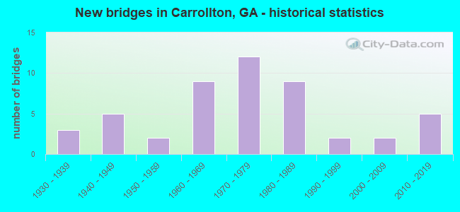
- New bridges - historical statistics
- 31930-1939
- 51940-1949
- 21950-1959
- 91960-1969
- 121970-1979
- 91980-1989
- 21990-1999
- 22000-2009
- 52010-2019
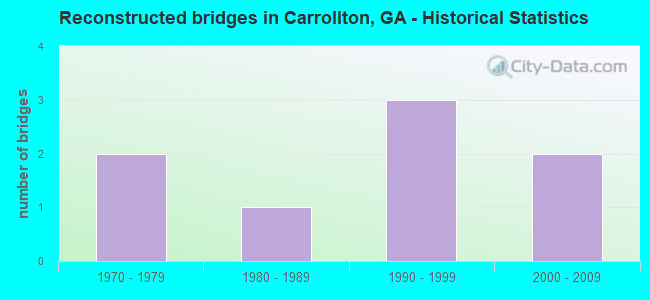
- Reconstructed bridges - Historical Statistics
- 21970-1979
- 11980-1989
- 31990-1999
- 22000-2009
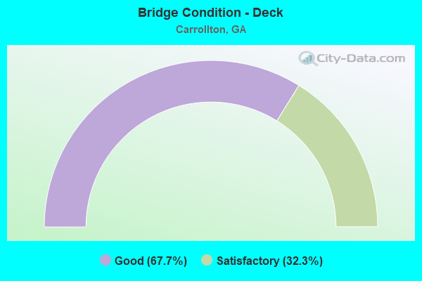
- Bridge Condition - Deck
- 67.7%Good
- 32.3%Satisfactory
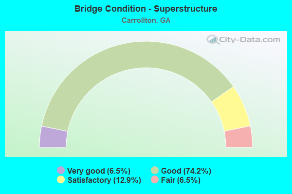
- Bridge Condition - Superstructure
- 6.5%Very good
- 74.2%Good
- 12.9%Satisfactory
- 6.5%Fair
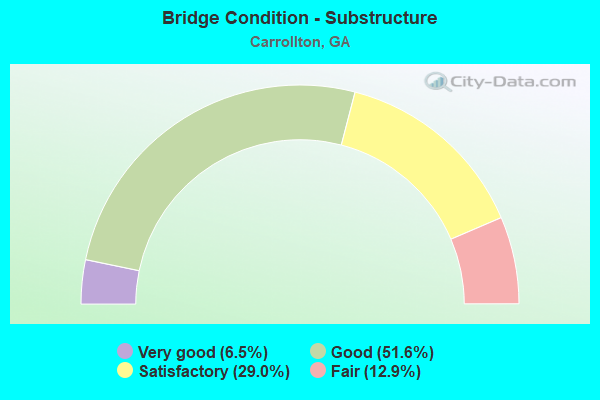
- Bridge Condition - Substructure
- 6.5%Very good
- 51.6%Good
- 29.0%Satisfactory
- 12.9%Fair
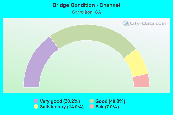
- Bridge Condition - Channel
- 30.2%Very good
- 48.8%Good
- 14.0%Satisfactory
- 7.0%Fair
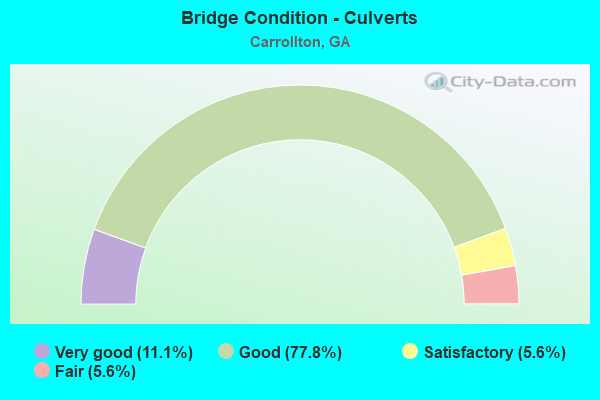
- Bridge Condition - Culverts
- 11.1%Very good
- 77.8%Good
- 5.6%Satisfactory
- 5.6%Fair
Find on map >> Show street view
Structure Number: 455152, Location: 4.5 MI N OF CARROLLTON (Lat: 33.635003, Lng: -85.110153), Route carried "on" structure: County highway 244, Year Built: 2003, Status: Open, Structure Length: 0.91m (2.99ft), Average Daily Traffic: 600 (year 2011), Truck Traffic: 1%, Average Future Daily Traffic: 900 (year 2031), Design Load: HS 20+Mod, Features Intersected: LITTLE BUCK CREEEK, Facility Carried by Structure: MILLER ACADEMY RD
Minimum Vertical Clearance: 30+ m (98+ ft), Kilometerpoint: 1.609, Lanes on structure: 2, Base Highway Network: Yes, Owner: County Highway Agency, Approaching Roadway Width: 6.1m (20.0ft), Skew: 1 degrees, Material/Design: Concrete, Design/Construction: Culvert, Number Of Spans In Main Unit: 3, Length of Maximum Span: 2.7m (8.9ft)
Condition: Channel: Good, Culverts: Good, Structural Evaluation: Better than present minimum criteria, Waterway Adequacy: Equal to present desirable criteria, Approach Roadway Alignment: Equal to present desirable criteria, Designated Inspection Frequency: Every 24 months, Inspection Date: July 2020, Bridge Improvement Cost: $117,000, Roadway Improvement Cost: $12,000, Total Project Cost: $176,000
Find on map >> Show street view
Structure Number: 455157, Location: 7 MILES SOUTH OF CARROLLT (Lat: 33.492239, Lng: -85.023139), Route carried "on" structure: County highway 1614, Year Built: 2009, Status: Open, Structure Length: 3.90m (12.80ft), Average Daily Traffic: 380 (year 2011), Truck Traffic: 1%, Average Future Daily Traffic: 570 (year 2031), Design Load: HS 20+Mod, Features Intersected: WHOOPING CREEK, Facility Carried by Structure: CLEM LOWELL ROAD
Minimum Vertical Clearance: 30+ m (98+ ft), Kilometerpoint: 3.219, Lanes on structure: 2, Base Highway Network: Yes, Owner: County Highway Agency, Approaching Roadway Width: 7.3m (24.0ft), Material/Design: Steel, Design/Construction: Truss - Thru, Number Of Spans In Main Unit: 1, Length of Maximum Span: 39.0m (128.0ft), Curb or Sidewalk Widths: Left: 0.0m, Right: 1.5m (4.9ft), Curb-To-Curb Width: 8.4m (27.6ft), Out-to-Out Width: 8.5m (27.9ft)
Condition: Deck: Good, Superstructure: Very good, Substructure: Very good, Channel: Good, Operating Rating: 66.2 metric tons, Method Used To Determine Operating Rating: Load Factor (LF), Inventory Rating: 41.7 metric tons, Method Used To Determine Inventory Rating: Load Factor (LF), Structural Evaluation: Equal to present desirable criteria, Deck Geometry: Somewhat better than minimum adequacy, Waterway Adequacy: Equal to present desirable criteria, Approach Roadway Alignment: Better than present minimum criteria, Designated Inspection Frequency: Every 24 months, Critical Feature Inspection Frequency: Every 12 months, Inspection Date: July 2020, Critical Feature Inspection Date: June 2021, Bridge Improvement Cost: $500,000, Roadway Improvement Cost: $50,000, Total Project Cost: $750,000, Deck Structure Type: Concrete Cast-file-Place
Find on map >> Show street view
Structure Number: 455158, Location: IN SOUTH CARROLLTON (Lat: 33.563044, Lng: -85.080169), Route carried "on" structure: City street 971, Year Built: 2010, Status: Open, Structure Length: 0.79m (2.59ft), Average Daily Traffic: 1,096 (year 2011), Truck Traffic: 1%, Average Future Daily Traffic: 1,644 (year 2031), Design Load: H 15, Features Intersected: BUFFALO CREEK, Facility Carried by Structure: NORTH ALLISON ROAD
Minimum Vertical Clearance: 30+ m (98+ ft), Kilometerpoint: 0.000, Lanes on structure: 2, Base Highway Network: Yes, Owner: City or Municipal Highway Agency, Approaching Roadway Width: 6.7m (22.0ft), Material/Design: Concrete, Design/Construction: Culvert, Number Of Spans In Main Unit: 3, Length of Maximum Span: 2.1m (6.9ft), Curb or Sidewalk Widths: Left: 0.2m (0.7ft), Right: 0.2m (0.7ft)
Condition: Channel: Good, Culverts: Good, Operating Rating: 41.7 metric tons, Method Used To Determine Operating Rating: Field evaluation and documented engineering judgment, Inventory Rating: 24.4 metric tons, Method Used To Determine Inventory Rating: Field evaluation and documented engineering judgment, Structural Evaluation: Equal to present minimum criteria, Waterway Adequacy: Equal to present desirable criteria, Approach Roadway Alignment: Equal to present desirable criteria, Designated Inspection Frequency: Every 24 months, Inspection Date: August 2020, Bridge Improvement Cost: $102,000, Roadway Improvement Cost: $10,000, Total Project Cost: $152,000
Find on map >> Show street view
Structure Number: 45516, Location: 6 MILES EAST OF CARROLLTO (Lat: 33.575100, Lng: -84.968578), Route carried "on" structure: County highway 457, Year Built: 2011, Status: Open, Structure Length: 2.74m (8.99ft), Average Daily Traffic: 1,890 (year 2011), Truck Traffic: 1%, Average Future Daily Traffic: 2,835 (year 2031), Design Load: HS 20+Mod, Features Intersected: SNAKE CREEK, Facility Carried by Structure: HORSLEY MILL ROAD
Minimum Vertical Clearance: 30+ m (98+ ft), Kilometerpoint: 8.047, Lanes on structure: 2, Base Highway Network: Yes, Owner: County Highway Agency, Approaching Roadway Width: 6.7m (22.0ft), Skew: 3 degrees, Material/Design: Steel, Design/Construction: Truss - Thru, Number Of Spans In Main Unit: 1, Length of Maximum Span: 27.4m (89.9ft), Curb-To-Curb Width: 8.5m (27.9ft), Out-to-Out Width: 8.5m (27.9ft)
Condition: Deck: Good, Superstructure: Good, Substructure: Very good, Channel: Very good, Operating Rating: 54.4 metric tons, Method Used To Determine Operating Rating: Load Factor (LF), Inventory Rating: 32.6 metric tons, Method Used To Determine Inventory Rating: Load Factor (LF), Structural Evaluation: Better than present minimum criteria, Deck Geometry: Somewhat better than minimum adequacy, Waterway Adequacy: Equal to present desirable criteria, Approach Roadway Alignment: Meets minimum limits, Designated Inspection Frequency: Every 24 months, Critical Feature Inspection Frequency: Every 12 months, Inspection Date: August 2020, Critical Feature Inspection Date: August 2021, Bridge Improvement Cost: $352,000, Roadway Improvement Cost: $35,000, Total Project Cost: $527,000, Deck Structure Type: Concrete Cast-file-Place
Find on map >> Show street view
Structure Number: 455161, Location: 4.4 MILES SOUTH WEST OF C (Lat: 33.525939, Lng: -85.118278), Route carried "on" structure: County highway 36, Year Built: 2011, Status: Open, Structure Length: 0.88m (2.89ft), Average Daily Traffic: 104 (year 2011), Truck Traffic: 1%, Average Future Daily Traffic: 156 (year 2030), Design Load: H 15, Features Intersected: BUFFALO CREEK, Facility Carried by Structure: LAUREL ROAD
Minimum Vertical Clearance: 30+ m (98+ ft), Kilometerpoint: 1.609, Lanes on structure: 1, Base Highway Network: Yes, Owner: County Highway Agency, Approaching Roadway Width: 5.5m (18.0ft), Material/Design: Steel, Design/Construction: Culvert, Number Of Spans In Main Unit: 3, Length of Maximum Span: 2.4m (7.9ft)
Condition: Channel: Very good, Culverts: Very good, Operating Rating: 41.7 metric tons, Method Used To Determine Operating Rating: Field evaluation and documented engineering judgment, Inventory Rating: 24.4 metric tons, Method Used To Determine Inventory Rating: Field evaluation and documented engineering judgment, Structural Evaluation: Equal to present minimum criteria, Waterway Adequacy: Superior to present desirable criteria, Approach Roadway Alignment: Equal to present desirable criteria, Designated Inspection Frequency: Every 24 months, Underwater Inspection Frequency: Every 60 months, Inspection Date: August 2020, Underwater Inspection Date: April 2020, Bridge Improvement Cost: $82,000, Roadway Improvement Cost: $8,000, Total Project Cost: $124,000
Find on map >> Show street view
Structure Number: 455166, Location: IN SOUTH CARROLLTON (Lat: 33.557558, Lng: -85.073308), Route carried "on" structure: US 27, Year Built: 1977, Year Reconstructed: 2014, Status: Open, Structure Length: 8.93m (29.30ft), Average Daily Traffic: 32,540 (year 2011), Truck Traffic: 1%, Average Future Daily Traffic: 48,810 (year 2031), Design Load: HS 20, Features Intersected: SR 166 (US 27 ALT)
Minimum Vertical Clearance: 30+ m (98+ ft), Kilometerpoint: 16.093, Lanes on structure: 2, Lanes under structure: 4, Base Highway Network: Yes, Owner: State Highway Agency, Approaching Roadway Width: 11.6m (38.1ft), Skew: 10 degrees, Material/Design: Steel continuous, Design/Construction: Stringer/Multi-beam, Number Of Spans In Main Unit: 4, Length of Maximum Span: 26.8m (87.9ft), Curb-To-Curb Width: 41.5m (136.2ft), Out-to-Out Width: 42.7m (140.1ft)
Condition: Deck: Good, Superstructure: Good, Substructure: Good, Operating Rating: 38.1 metric tons, Method Used To Determine Operating Rating: Load Factor (LF), Inventory Rating: 22.6 metric tons, Method Used To Determine Inventory Rating: Load Factor (LF), Structural Evaluation: Somewhat better than minimum adequacy, Deck Geometry: Superior to present desirable criteria, Underclear: Better than present minimum criteria, Approach Roadway Alignment: Equal to present desirable criteria, Length Of Structure Improvement: 10.73m (35.20ft), Designated Inspection Frequency: Every 24 months, Inspection Date: August 2020, Bridge Improvement Cost: $26,048,000, Roadway Improvement Cost: $2,604,000, Total Project Cost: $39,072,000 ( Estimate for 2014), Deck Structure Type: Concrete Cast-file-Place
Find on map >> Show street view
Structure Number: 455167, Location: IN SOUTH CARROLLTON (Lat: 33.561753, Lng: -85.074269), Route carried "on" structure: City street 800, Year Built: 2013, Status: Open, Structure Length: 0.98m (3.22ft), Average Daily Traffic: 7,740 (year 2011), Truck Traffic: 1%, Average Future Daily Traffic: 11,610 (year 2031), Design Load: HS 20+Mod, Features Intersected: BUFFALO CREEK, Facility Carried by Structure: ROOP STREET
Minimum Vertical Clearance: 30+ m (98+ ft), Kilometerpoint: 0.000, Lanes on structure: 1, Base Highway Network: Yes, Owner: City or Municipal Highway Agency, Approaching Roadway Width: 6.1m (20.0ft), Material/Design: Concrete, Design/Construction: Culvert, Number Of Spans In Main Unit: 3, Length of Maximum Span: 3.0m (9.8ft)
Condition: Channel: Very good, Culverts: Good, Inventory Rating: 78.0 metric tons, Method Used To Determine Inventory Rating: Load Factor (LF), Structural Evaluation: Better than present minimum criteria, Waterway Adequacy: Superior to present desirable criteria, Approach Roadway Alignment: Equal to present desirable criteria, Length Of Structure Improvement: 1.17m (3.84ft), Designated Inspection Frequency: Every 24 months, Inspection Date: August 2020, Bridge Improvement Cost: $2,841,000, Roadway Improvement Cost: $284,000, Total Project Cost: $4,262,000 ( Estimate for 2014)
Find on map >> Show street view
Structure Number: 455168, Location: IN SOUTH CARROLLTON (Lat: 33.563194, Lng: -85.082614), Route carried "on" structure: City street 1014, Year Built: 2017, Status: Open, Structure Length: 1.04m (3.41ft), Average Daily Traffic: 1,096 (year 2011), Truck Traffic: 1%, Average Future Daily Traffic: 1,644 (year 2031), Design Load: HS 20, Features Intersected: BUFFALO CREEK, Facility Carried by Structure: STADIUM DRIVE
Minimum Vertical Clearance: 30+ m (98+ ft), Kilometerpoint: 0.000, Lanes on structure: 3, Base Highway Network: Yes, Owner: City or Municipal Highway Agency, Approaching Roadway Width: 10.1m (33.1ft), Material/Design: Concrete, Design/Construction: Culvert, Number Of Spans In Main Unit: 3, Length of Maximum Span: 3.0m (9.8ft), Curb or Sidewalk Widths: Left: 1.5m (4.9ft), Right: 1.5m (4.9ft)
Condition: Channel: Very good, Culverts: Very good, Operating Rating: 40.8 metric tons, Method Used To Determine Operating Rating: Load Factor (LF), Inventory Rating: 24.4 metric tons, Method Used To Determine Inventory Rating: Load Factor (LF), Structural Evaluation: Equal to present minimum criteria, Waterway Adequacy: Equal to present desirable criteria, Approach Roadway Alignment: Better than present minimum criteria, Length Of Structure Improvement: 1.25m (4.10ft), Designated Inspection Frequency: Every 24 months, Inspection Date: August 2020, Bridge Improvement Cost: $3,034,000, Roadway Improvement Cost: $303,000, Total Project Cost: $4,551,000 ( Estimate for 2018)
Find on map >> Show street view
Structure Number: 45007, Location: IN CENTRAL CARROLLTON (Lat: 33.575089, Lng: -85.079028), Route carried "under" structure: US 27, Structure Length: 0. m, Average Daily Traffic: 22,170 (year 2009), Truck Traffic: 1%, Features Intersected: M-808 SOUTH STREET, Facility Carried by Structure: SOUTH STREET
Minimum Vertical Clearance: 5.76m (18.90ft), Kilometerpoint: 19.312, Lanes on structure: 4, Length of Maximum Span: 0.0m
Find on map >> Show street view
Structure Number: 450072, Location: 2 MI E OF CARROLLTON (Lat: 33.576981, Lng: -85.041681), Route carried "under" structure: State highway 166, Structure Length: 0. m, Average Daily Traffic: 23,400 (year 1999), Truck Traffic: 1%, Features Intersected: M-812 HORSELY MILL ROAD, Facility Carried by Structure: HORSELY MILL ROAD
Minimum Vertical Clearance: 5.58m (18.31ft), Kilometerpoint: 28.968, Lanes on structure: 2, Length of Maximum Span: 0.0m
Find on map >> Show street view
Structure Number: 450096, Location: IN CARROLLTON (Lat: 33.576114, Lng: -85.078939), Route carried "under" structure: US 27, Structure Length: 0. m, Average Daily Traffic: 18,400 (year 2011), Truck Traffic: 10%, Features Intersected: SR 1 (US 27), Facility Carried by Structure: NORFOLK SOU (71923
Minimum Vertical Clearance: 5.23m (17.16ft), Kilometerpoint: 19.312, Lanes on structure: 6, Length of Maximum Span: 0.0m
Find on map >> Show street view
Structure Number: 455166, Location: IN SOUTH CARROLLTON (Lat: 33.557558, Lng: -85.073308), Route carried "under" structure: Alternate US 27, Structure Length: 0. m, Average Daily Traffic: 15,200 (year 1999), Truck Traffic: 1%, Features Intersected: SR 166 (US 27)
Minimum Vertical Clearance: 6.01m (19.72ft), Kilometerpoint: 24.140, Lanes on structure: 2, Length of Maximum Span: 0.0m