Bridge Statistics for Chicopee, Massachusetts (MA)
Condition, Traffic, Stress, Structural Evaluation, Project Costs
- National Bridge Inventory (NBI) Statistics
- 55Number of bridges
- 1,411ft / 430mTotal length
- $594,613,000Total costs
- 1,633,959Total average daily traffic
- 171,578Total average daily truck traffic
- National Bridge Inventory (NBI) Registered Bridges for Chicopee
- No street view available for this location
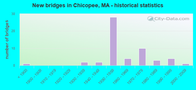
- New bridges - historical statistics
- 1Before 1900
- 21930-1939
- 21940-1949
- 281950-1959
- 41960-1969
- 101970-1979
- 31980-1989
- 41990-1999
- 12000-2009
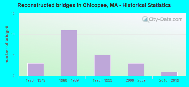
- Reconstructed bridges - Historical Statistics
- 31970-1979
- 111980-1989
- 51990-1999
- 32000-2009
- 12010-2019
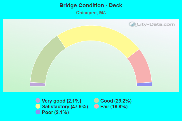
- Bridge Condition - Deck
- 2.1%Very good
- 29.2%Good
- 47.9%Satisfactory
- 18.8%Fair
- 2.1%Poor
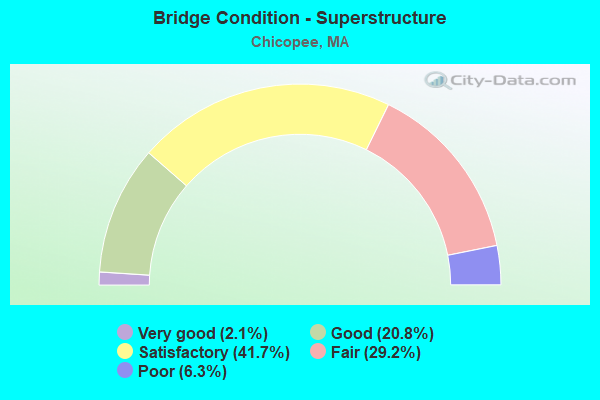
- Bridge Condition - Superstructure
- 2.1%Very good
- 20.8%Good
- 41.7%Satisfactory
- 29.2%Fair
- 6.3%Poor
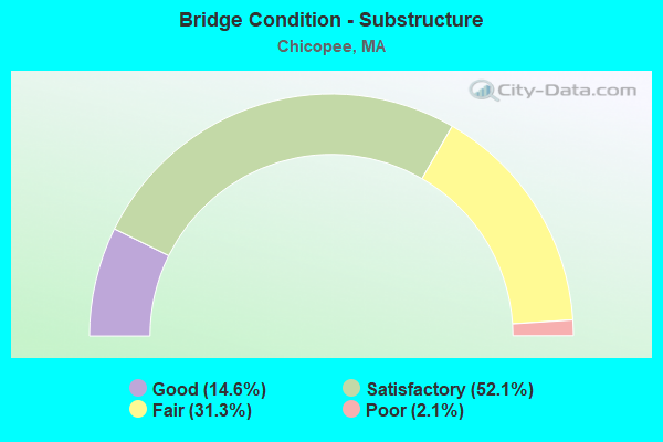
- Bridge Condition - Substructure
- 14.6%Good
- 52.1%Satisfactory
- 31.3%Fair
- 2.1%Poor
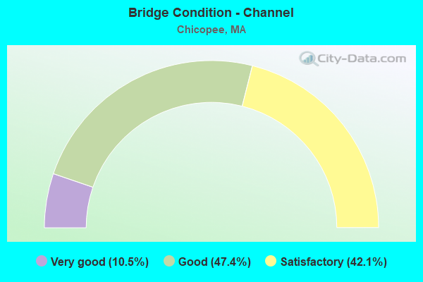
- Bridge Condition - Channel
- 10.5%Very good
- 47.4%Good
- 42.1%Satisfactory
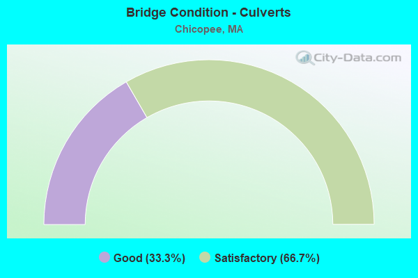
- Bridge Condition - Culverts
- 33.3%Good
- 66.7%Satisfactory
Find on map >> Show street view
Structure Number: C1300313UDOT634, Location: .3 M N JCT I391 (Lat: 42.159250, Lng: -72.612964), Route carried "on" structure: State highway 116, Year Built: 1971, Status: Open, Structure Length: 2.89m (9.48ft), Average Daily Traffic: 32,500 (year 2018), Truck Traffic: 4%, Average Future Daily Traffic: 20,373 (year 2031), Design Load: H 20, Features Intersected: RR BMRR
Minimum Vertical Clearance: 30+ m (98+ ft), Kilometerpoint: 7.644, Lanes on structure: 4, Owner: State Highway Agency, Approaching Roadway Width: 16.5m (54.1ft), Skew: 35 degrees, Material/Design: Steel, Design/Construction: Girder and Floorbeam System, Number Of Spans In Main Unit: 1, Length of Maximum Span: 27.5m (90.2ft), Curb or Sidewalk Widths: Left: 0.5m (1.6ft), Right: 1.5m (4.9ft), Curb-To-Curb Width: 16.5m (54.1ft), Out-to-Out Width: 21.9m (71.9ft)
Condition: Deck: Satisfactory, Superstructure: Poor, Substructure: Satisfactory, Operating Rating: 48.8 metric tons, Method Used To Determine Operating Rating: Load Factor (LF), Inventory Rating: 29.3 metric tons, Method Used To Determine Inventory Rating: Load Factor (LF), Structural Evaluation: Meets minimum limits, Deck Geometry: Meets minimum limits, Underclear: Somewhat better than minimum adequacy, Approach Roadway Alignment: Equal to present desirable criteria, Length Of Structure Improvement: 3.90m (12.80ft), Designated Inspection Frequency: Every 12 months, Other Special Inspection Frequency: Every 12 months, Inspection Date: August 2020, Other Special Inspection Date: August 2021, Bridge Improvement Cost: $5,618,000, Roadway Improvement Cost: $562,000, Total Project Cost: $8,428,000 ( Estimate for 2022), Deck Structure Type: Concrete Cast-file-Place, Wearing Surface/Protective System: Wearing Surface: Bituminous, Membrane: Built-up
Find on map >> Show street view
Structure Number: C1300413TDOT634, Location: .3 M E JCT MEADOW ST. (Lat: 42.171278, Lng: -72.611525), Route carried "on" structure: City street , Year Built: 1993, Status: Open, Structure Length: 7.00m (22.97ft), Average Daily Traffic: 4,655 (year 2004), Truck Traffic: 6%, Average Future Daily Traffic: 7,352 (year 2031), Design Load: HS 20, Features Intersected: RR BMRR, Facility Carried by Structure: HWY MCKINSTRY AV
Minimum Vertical Clearance: 30+ m (98+ ft), Kilometerpoint: 2.108, Lanes on structure: 2, Owner: State Highway Agency, Approaching Roadway Width: 12.2m (40.0ft), Material/Design: Steel continuous, Design/Construction: Stringer/Multi-beam, Number Of Spans In Main Unit: 4, Length of Maximum Span: 22.1m (72.5ft), Curb or Sidewalk Widths: Left: 0.2m (0.7ft), Right: 1.8m (5.9ft), Curb-To-Curb Width: 12.2m (40.0ft), Out-to-Out Width: 15.0m (49.2ft)
Condition: Deck: Good, Superstructure: Good, Substructure: Good, Operating Rating: 65.0 metric tons, Method Used To Determine Operating Rating: Load Factor (LF), Inventory Rating: 39.0 metric tons, Method Used To Determine Inventory Rating: Load Factor (LF), Structural Evaluation: Better than present minimum criteria, Deck Geometry: Equal to present minimum criteria, Underclear: Meets minimum limits, Approach Roadway Alignment: Somewhat better than minimum adequacy, Length Of Structure Improvement: 7.10m (23.29ft), Designated Inspection Frequency: Every 24 months, Inspection Date: April 2020, Bridge Improvement Cost: $804,000, Roadway Improvement Cost: $81,000, Total Project Cost: $1,207,000 ( Estimate for 2022), Deck Structure Type: Concrete Cast-file-Place, Wearing Surface/Protective System: Wearing Surface: Bituminous, Membrane: Built-up, Deck Protection: Epoxy Coated Reinforcing
Find on map >> Show street view
Structure Number: C1300712GDOTNBI, Location: AT INT FRONT/SPRINGFIELD (Lat: 42.149175, Lng: -72.607828), Route carried "on" structure: State highway 116, Year Built: 1931, Year Reconstructed: 2013, Status: Open, Structure Length: 1.29m (4.23ft), Average Daily Traffic: 32,500 (year 2017), Truck Traffic: 7%, Average Future Daily Traffic: 24,479 (year 2032), Design Load: HS 25 or greater, Features Intersected: WATER DWIGHT MFG CANAL
Minimum Vertical Clearance: 30+ m (98+ ft), Kilometerpoint: 1.078, Lanes on structure: 2, Base Highway Network: Yes, Owner: State Highway Agency, Approaching Roadway Width: 11.0m (36.1ft), Material/Design: Concrete, Design/Construction: Tee Beam, Number Of Spans In Main Unit: 1, Length of Maximum Span: 12.6m (41.3ft), Curb or Sidewalk Widths: Left: 2.3m (7.5ft), Right: 2.3m (7.5ft), Curb-To-Curb Width: 11.0m (36.1ft), Out-to-Out Width: 17.5m (57.4ft)
Condition: Deck: Satisfactory, Superstructure: Good, Substructure: Satisfactory, Channel: Good, Operating Rating: 73.1 metric tons, Method Used To Determine Operating Rating: Load Factor (LF), Inventory Rating: 43.8 metric tons, Method Used To Determine Inventory Rating: Load Factor (LF), Structural Evaluation: Equal to present minimum criteria, Deck Geometry: Meets minimum limits, Waterway Adequacy: Equal to present desirable criteria, Approach Roadway Alignment: Better than present minimum criteria, Length Of Structure Improvement: 1.30m (4.27ft), Designated Inspection Frequency: Every 24 months, Inspection Date: July 2021, Bridge Improvement Cost: $295,000, Roadway Improvement Cost: $30,000, Total Project Cost: $443,000 ( Estimate for 2022), Deck Structure Type: Concrete Cast-file-Place, Wearing Surface/Protective System: Wearing Surface: Bituminous, Membrane: Preformed Fabric, Deck Protection: Epoxy Coated Reinforcing
Find on map >> Show street view
Structure Number: C1300812HDOTNBI, Location: AT INT OF GRANBY RD (Lat: 42.150364, Lng: -72.607797), Route carried "on" structure: State highway 116, Year Built: 1931, Year Reconstructed: 2013, Status: Open, Structure Length: 9.36m (30.71ft), Average Daily Traffic: 33,164 (year 2015), Truck Traffic: 7%, Average Future Daily Traffic: 24,479 (year 2032), Design Load: HL 93, Features Intersected: WATER CHICOPEE RIVER
Minimum Vertical Clearance: 30+ m (98+ ft), Kilometerpoint: 1.255, Lanes on structure: 3, Base Highway Network: Yes, Owner: State Highway Agency, Approaching Roadway Width: 16.0m (52.5ft), Material/Design: Steel continuous, Design/Construction: Stringer/Multi-beam, Number Of Spans In Main Unit: 3, Length of Maximum Span: 31.1m (102.0ft), Curb or Sidewalk Widths: Left: 1.6m (5.2ft), Right: 1.6m (5.2ft), Curb-To-Curb Width: 12.2m (40.0ft), Out-to-Out Width: 16.3m (53.5ft)
Condition: Deck: Very good, Superstructure: Very good, Substructure: Good, Channel: Very good, Operating Rating: 64.8 metric tons, Method Used To Determine Operating Rating: Load and Resistance Factor Rating (LRFR) rating reported by rating factor(RF) method using HL-93 loadings, Inventory Rating: 51.8 metric tons, Method Used To Determine Inventory Rating: Load and Resistance Factor Rating (LRFR) rating reported by rating factor(RF) method using HL-93 loadings, Structural Evaluation: Better than present minimum criteria, Deck Geometry: Meets minimum limits, Waterway Adequacy: Superior to present desirable criteria, Approach Roadway Alignment: Superior to present desirable criteria, Length Of Structure Improvement: 9.40m (30.84ft), Designated Inspection Frequency: Every 24 months, Underwater Inspection Frequency: Every 48 months, Inspection Date: July 2021, Underwater Inspection Date: July 2018, Bridge Improvement Cost: $5,495,000, Roadway Improvement Cost: $550,000, Total Project Cost: $8,243,000 ( Estimate for 2022), Deck Structure Type: Concrete Precast Panels, Wearing Surface/Protective System: Wearing Surface: Bituminous, Membrane: Preformed Fabric, Deck Protection: Epoxy Coated Reinforcing
Find on map >> Show street view
Structure Number: C130118P6DOTNBI, Location: SOUTH END OF ROUTE 33 (Lat: 42.159922, Lng: -72.581919), Route carried "on" structure: State highway 141, Year Built: 2006, Status: Open, Structure Length: 11.74m (38.52ft), Average Daily Traffic: 9,000 (year 2000), Truck Traffic: 12%, Average Future Daily Traffic: 14,214 (year 2031), Design Load: HS 25 or greater, Features Intersected: WATER CHICOPEE RIVER
Minimum Vertical Clearance: 30+ m (98+ ft), Kilometerpoint: 16.100, Lanes on structure: 5, Base Highway Network: Yes, Owner: State Highway Agency, Approaching Roadway Width: 21.0m (68.9ft), Material/Design: Prestressed concrete, Design/Construction: Stringer/Multi-beam, Number Of Spans In Main Unit: 4, Length of Maximum Span: 29.2m (95.8ft), Curb or Sidewalk Widths: Left: 1.8m (5.9ft), Right: 1.8m (5.9ft), Curb-To-Curb Width: 21.0m (68.9ft), Out-to-Out Width: 25.4m (83.3ft)
Condition: Deck: Good, Superstructure: Good, Substructure: Good, Channel: Very good, Operating Rating: 71.2 metric tons, Method Used To Determine Operating Rating: Load Factor (LF), Inventory Rating: 42.7 metric tons, Method Used To Determine Inventory Rating: Load Factor (LF), Structural Evaluation: Better than present minimum criteria, Deck Geometry: Somewhat better than minimum adequacy, Waterway Adequacy: Superior to present desirable criteria, Approach Roadway Alignment: Equal to present desirable criteria, Length Of Structure Improvement: 11.80m (38.71ft), Designated Inspection Frequency: Every 24 months, Inspection Date: October 2020, Bridge Improvement Cost: $5,341,000, Roadway Improvement Cost: $535,000, Total Project Cost: $8,012,000 ( Estimate for 2022), Deck Structure Type: Concrete Cast-file-Place, Wearing Surface/Protective System: Wearing Surface: Bituminous, Membrane: Preformed Fabric, Deck Protection: Epoxy Coated Reinforcing
Find on map >> Show street view
Structure Number: C1301213RDOT634, Location: AT CHICOPEE-HOLYOKE T.L. (Lat: 42.195058, Lng: -72.601297), Route carried "on" structure: State highway 116, Year Built: 1891, Year Reconstructed: 2015, Status: Open, Structure Length: 24.37m (79.95ft), Average Daily Traffic: 17,700 (year 2017), Truck Traffic: 5%, Average Future Daily Traffic: 23,690 (year 2032), Design Load: H 20, Features Intersected: COMB CONN RIV & PVRR
Minimum Vertical Clearance: 4.01m (13.16ft), Kilometerpoint: 12.617, Lanes on structure: 2, Owner: State Highway Agency, Approaching Roadway Width: 8.3m (27.2ft), Navigation Control: Yes ( Vertical Clearance: 9.1m (29.9ft), Horizontal Clearance: 48.8m (160.1ft)), Material/Design: Steel, Design/Construction: Truss - Thru, Number Of Spans In Main Unit: 4, Number Of Approach Spans: 2, Length of Maximum Span: 51.8m (169.9ft), Curb or Sidewalk Widths: Left: 2.0m (6.6ft), Right: 2.0m (6.6ft), Curb-To-Curb Width: 8.3m (27.2ft), Out-to-Out Width: 9.3m (30.5ft)
Condition: Deck: Good, Superstructure: Fair, Substructure: Satisfactory, Channel: Satisfactory, Operating Rating: 44.4 metric tons, Method Used To Determine Operating Rating: Load Factor (LF), Inventory Rating: 26.6 metric tons, Method Used To Determine Inventory Rating: Load Factor (LF), Structural Evaluation: Somewhat better than minimum adequacy, Deck Geometry: High priority of corrective action, Underclear: Meets minimum limits, Waterway Adequacy: Superior to present desirable criteria, Approach Roadway Alignment: Somewhat better than minimum adequacy, Designated Inspection Frequency: Every 24 months, Critical Feature Inspection Frequency: Every 24 months, Underwater Inspection Frequency: Every 36 months, Inspection Date: October 2021, Critical Feature Inspection Date: October 2021, Underwater Inspection Date: September 2019, Deck Structure Type: Other, Wearing Surface/Protective System: Wearing Surface: Bituminous, Membrane: Preformed Fabric, Deck Protection: Epoxy Coated Reinforcing
Find on map >> Show street view
Structure Number: C130150PMMUNNBI, Location: 300' N. JCT FRONT ST (Lat: 42.149444, Lng: -72.603750), Route carried "on" structure: City street , Year Built: 1943, Year Reconstructed: 1993, Status: Open, Structure Length: 1.78m (5.84ft), Average Daily Traffic: 130 (year 2019), Truck Traffic: 5%, Average Future Daily Traffic: 948 (year 2032), Design Load: HS 20, Features Intersected: WATER DWIGHT MFG CANAL, Facility Carried by Structure: HWY GRAPE ST
Minimum Vertical Clearance: 30+ m (98+ ft), Kilometerpoint: 0.515, Lanes on structure: 2, Owner: City or Municipal Highway Agency, Approaching Roadway Width: 7.3m (24.0ft), Material/Design: Steel, Design/Construction: Stringer/Multi-beam, Number Of Spans In Main Unit: 1, Length of Maximum Span: 16.6m (54.5ft), Curb or Sidewalk Widths: Left: 0.2m (0.7ft), Right: 0.2m (0.7ft), Curb-To-Curb Width: 7.3m (24.0ft), Out-to-Out Width: 8.6m (28.2ft)
Condition: Deck: Satisfactory, Superstructure: Fair, Substructure: Satisfactory, Channel: Good, Operating Rating: 73.1 metric tons, Method Used To Determine Operating Rating: Load Factor (LF), Inventory Rating: 43.8 metric tons, Method Used To Determine Inventory Rating: Load Factor (LF), Structural Evaluation: Somewhat better than minimum adequacy, Deck Geometry: Somewhat better than minimum adequacy, Waterway Adequacy: Better than present minimum criteria, Approach Roadway Alignment: Equal to present minimum criteria, Length Of Structure Improvement: 1.80m (5.91ft), Designated Inspection Frequency: Every 22 months, Other Special Inspection Frequency: Every 22 months, Inspection Date: November 2021, Other Special Inspection Date: November 2021, Bridge Improvement Cost: $609,000, Roadway Improvement Cost: $61,000, Total Project Cost: $914,000 ( Estimate for 2022), Deck Structure Type: Concrete Cast-file-Place, Wearing Surface/Protective System: Wearing Surface: Latex Concrete, Deck Protection: Epoxy Coated Reinforcing
Find on map >> Show street view
Structure Number: C130174HUDOTNBI, Location: MM 49.5 ON I-90 EB (Lat: 42.168964, Lng: -72.573231), Route carried "on" structure: Interstate 90, Year Built: 1957, Year Reconstructed: 1993, Status: Open, Structure Length: 3.75m (12.30ft), Average Daily Traffic: 35,590 (year 2018), Truck Traffic: 12%, Average Future Daily Traffic: 49,614 (year 2033), Design Load: HS 20+Mod, Features Intersected: HWY SHERIDAN ST
Minimum Vertical Clearance: 30+ m (98+ ft), Kilometerpoint: 79.499, Lanes on structure: 2, Lanes under structure: 2, Base Highway Network: Yes, Toll: On toll road, Owner: State Highway Agency, Approaching Roadway Width: 12.8m (42.0ft), Skew: 2 degrees, Material/Design: Steel, Design/Construction: Stringer/Multi-beam, Number Of Spans In Main Unit: 3, Length of Maximum Span: 17.5m (57.4ft), Curb-To-Curb Width: 12.8m (42.0ft), Out-to-Out Width: 13.7m (44.9ft)
Condition: Deck: Good, Superstructure: Fair, Substructure: Fair, Operating Rating: 77.0 metric tons, Method Used To Determine Operating Rating: Load Factor (LF), Inventory Rating: 46.1 metric tons, Method Used To Determine Inventory Rating: Load Factor (LF), Structural Evaluation: Somewhat better than minimum adequacy, Deck Geometry: Equal to present desirable criteria, Underclear: High priority of corrective action, Approach Roadway Alignment: Equal to present desirable criteria, Length Of Structure Improvement: 3.80m (12.47ft), Designated Inspection Frequency: Every 24 months, Inspection Date: Febuary 2022, Bridge Improvement Cost: $2,045,000, Roadway Improvement Cost: $205,000, Total Project Cost: $3,068,000 ( Estimate for 2022), Deck Structure Type: Concrete Cast-file-Place, Wearing Surface/Protective System: Wearing Surface: Bituminous, Membrane: Preformed Fabric, Deck Protection: Epoxy Coated Reinforcing
Find on map >> Show street view
Structure Number: C130174HVDOTNBI, Location: MM 49.5 ON I-90 WB (Lat: 42.169303, Lng: -72.573008), Route carried "on" structure: Interstate 90, Year Built: 1957, Year Reconstructed: 1993, Status: Open, Structure Length: 3.75m (12.30ft), Average Daily Traffic: 25,732 (year 2018), Truck Traffic: 12%, Average Future Daily Traffic: 37,390 (year 2033), Design Load: H 20, Features Intersected: HWY SHERIDAN ST
Minimum Vertical Clearance: 30+ m (98+ ft), Kilometerpoint: 79.499, Lanes on structure: 2, Lanes under structure: 2, Base Highway Network: Yes, Toll: On toll road, Owner: State Highway Agency, Approaching Roadway Width: 12.8m (42.0ft), Skew: 2 degrees, Material/Design: Steel, Design/Construction: Stringer/Multi-beam, Number Of Spans In Main Unit: 3, Length of Maximum Span: 18.0m (59.1ft), Curb-To-Curb Width: 12.8m (42.0ft), Out-to-Out Width: 13.7m (44.9ft)
Condition: Deck: Good, Superstructure: Fair, Substructure: Satisfactory, Operating Rating: 77.0 metric tons, Method Used To Determine Operating Rating: Load Factor (LF), Inventory Rating: 46.1 metric tons, Method Used To Determine Inventory Rating: Load Factor (LF), Structural Evaluation: Somewhat better than minimum adequacy, Deck Geometry: Equal to present desirable criteria, Underclear: High priority of corrective action, Approach Roadway Alignment: Equal to present desirable criteria, Length Of Structure Improvement: 3.80m (12.47ft), Designated Inspection Frequency: Every 24 months, Inspection Date: Febuary 2022, Bridge Improvement Cost: $2,045,000, Roadway Improvement Cost: $205,000, Total Project Cost: $3,068,000 ( Estimate for 2022), Deck Structure Type: Concrete Cast-file-Place, Wearing Surface/Protective System: Wearing Surface: Bituminous, Membrane: Preformed Fabric, Deck Protection: Epoxy Coated Reinforcing
Find on map >> Show street view
Structure Number: C130184HWDOTNBI, Location: MM 49.2 ON I-90 EB (Lat: 42.169319, Lng: -72.577944), Route carried "on" structure: Interstate 90, Year Built: 1957, Year Reconstructed: 1992, Status: Open, Structure Length: 5.46m (17.91ft), Average Daily Traffic: 32,675 (year 2017), Truck Traffic: 12%, Average Future Daily Traffic: 49,614 (year 2032), Design Load: HS 20+Mod, Features Intersected: ST 33 MEMORIAL DR
Minimum Vertical Clearance: 30+ m (98+ ft), Kilometerpoint: 79.178, Lanes on structure: 2, Lanes under structure: 4, Base Highway Network: Yes, Toll: On toll road, Owner: State Highway Agency, Approaching Roadway Width: 12.8m (42.0ft), Skew: 1 degrees, Material/Design: Steel continuous, Design/Construction: Stringer/Multi-beam, Number Of Spans In Main Unit: 4, Length of Maximum Span: 15.6m (51.2ft), Curb-To-Curb Width: 12.8m (42.0ft), Out-to-Out Width: 13.7m (44.9ft)
Condition: Deck: Satisfactory, Superstructure: Satisfactory, Substructure: Satisfactory, Operating Rating: 59.3 metric tons, Method Used To Determine Operating Rating: Load Factor (LF), Inventory Rating: 35.6 metric tons, Method Used To Determine Inventory Rating: Load Factor (LF), Structural Evaluation: Equal to present minimum criteria, Deck Geometry: Equal to present desirable criteria, Underclear: Superior to present desirable criteria, Approach Roadway Alignment: Equal to present desirable criteria, Length Of Structure Improvement: 5.50m (18.04ft), Designated Inspection Frequency: Every 24 months, Inspection Date: Febuary 2021, Bridge Improvement Cost: $592,000, Roadway Improvement Cost: $60,000, Total Project Cost: $889,000 ( Estimate for 2022), Deck Structure Type: Concrete Cast-file-Place, Wearing Surface/Protective System: Wearing Surface: Bituminous, Membrane: Preformed Fabric, Deck Protection: Epoxy Coated Reinforcing
Find on map >> Show street view
Structure Number: C130184HXDOTNBI, Location: MM 49.2 ON I-90 WB (Lat: 42.169703, Lng: -72.577792), Route carried "on" structure: Interstate 90, Year Built: 1957, Year Reconstructed: 1992, Status: Open, Structure Length: 5.06m (16.60ft), Average Daily Traffic: 25,031 (year 2017), Truck Traffic: 12%, Average Future Daily Traffic: 49,614 (year 2032), Design Load: HS 20+Mod, Features Intersected: ST 33 MEMORIAL DR
Minimum Vertical Clearance: 30+ m (98+ ft), Kilometerpoint: 79.178, Lanes on structure: 2, Lanes under structure: 4, Base Highway Network: Yes, Toll: On toll road, Owner: State Highway Agency, Approaching Roadway Width: 16.5m (54.1ft), Skew: 1 degrees, Material/Design: Steel continuous, Design/Construction: Stringer/Multi-beam, Number Of Spans In Main Unit: 4, Length of Maximum Span: 15.6m (51.2ft), Curb-To-Curb Width: 16.5m (54.1ft), Out-to-Out Width: 17.4m (57.1ft)
Condition: Deck: Satisfactory, Superstructure: Satisfactory, Substructure: Satisfactory, Operating Rating: 63.3 metric tons, Method Used To Determine Operating Rating: Load Factor (LF), Inventory Rating: 37.9 metric tons, Method Used To Determine Inventory Rating: Load Factor (LF), Structural Evaluation: Equal to present minimum criteria, Deck Geometry: Superior to present desirable criteria, Underclear: Equal to present minimum criteria, Approach Roadway Alignment: Equal to present desirable criteria, Length Of Structure Improvement: 5.10m (16.73ft), Designated Inspection Frequency: Every 24 months, Inspection Date: Febuary 2021, Bridge Improvement Cost: $698,000, Roadway Improvement Cost: $70,000, Total Project Cost: $1,048,000 ( Estimate for 2022), Deck Structure Type: Concrete Cast-file-Place, Wearing Surface/Protective System: Wearing Surface: Bituminous, Membrane: Preformed Fabric, Deck Protection: Epoxy Coated Reinforcing
Find on map >> Show street view
Structure Number: C130194J1DOTNBI, Location: MM 48.8 ON I-90 EB (Lat: 42.169439, Lng: -72.585953), Route carried "on" structure: Interstate 90, Year Built: 1957, Year Reconstructed: 1979, Status: Open, Structure Length: 3.74m (12.27ft), Average Daily Traffic: 24,073 (year 2018), Truck Traffic: 12%, Average Future Daily Traffic: 51,060 (year 2033), Design Load: HS 20, Features Intersected: HWY MONTGOMERY ST
Minimum Vertical Clearance: 30+ m (98+ ft), Kilometerpoint: 78.534, Lanes on structure: 2, Lanes under structure: 2, Base Highway Network: Yes, Toll: On toll road, Owner: State Highway Agency, Approaching Roadway Width: 16.2m (53.1ft), Material/Design: Steel continuous, Design/Construction: Stringer/Multi-beam, Number Of Spans In Main Unit: 3, Length of Maximum Span: 16.9m (55.4ft), Curb-To-Curb Width: 16.2m (53.1ft), Out-to-Out Width: 17.5m (57.4ft)
Condition: Deck: Fair, Superstructure: Satisfactory, Substructure: Satisfactory, Operating Rating: 75.7 metric tons, Method Used To Determine Operating Rating: Load Factor (LF), Inventory Rating: 45.3 metric tons, Method Used To Determine Inventory Rating: Load Factor (LF), Structural Evaluation: Equal to present minimum criteria, Deck Geometry: Superior to present desirable criteria, Underclear: High priority of corrective action, Approach Roadway Alignment: Equal to present desirable criteria, Length Of Structure Improvement: 3.80m (12.47ft), Designated Inspection Frequency: Every 24 months, Inspection Date: Febuary 2022, Bridge Improvement Cost: $1,254,000, Roadway Improvement Cost: $126,000, Total Project Cost: $1,882,000 ( Estimate for 2022), Deck Structure Type: Concrete Cast-file-Place, Wearing Surface/Protective System: Wearing Surface: Bituminous, Membrane: Preformed Fabric, Deck Protection: Epoxy Coated Reinforcing
Find on map >> Show street view
Structure Number: C130194J2DOTNBI, Location: MM 48.8 ON I-90 WB (Lat: 42.169814, Lng: -72.586050), Route carried "on" structure: Interstate 90, Year Built: 1957, Year Reconstructed: 1979, Status: Open, Structure Length: 3.69m (12.11ft), Average Daily Traffic: 25,405 (year 2018), Truck Traffic: 12%, Average Future Daily Traffic: 51,060 (year 2033), Design Load: HS 20, Features Intersected: HWY MONTGOMERY ST
Minimum Vertical Clearance: 30+ m (98+ ft), Kilometerpoint: 78.534, Lanes on structure: 2, Lanes under structure: 2, Base Highway Network: Yes, Toll: On toll road, Owner: State Highway Agency, Approaching Roadway Width: 11.6m (38.1ft), Material/Design: Steel continuous, Design/Construction: Stringer/Multi-beam, Number Of Spans In Main Unit: 3, Length of Maximum Span: 16.8m (55.1ft), Curb-To-Curb Width: 12.5m (41.0ft), Out-to-Out Width: 13.8m (45.3ft)
Condition: Deck: Fair, Superstructure: Satisfactory, Substructure: Good, Operating Rating: 72.7 metric tons, Method Used To Determine Operating Rating: Load Factor (LF), Inventory Rating: 43.5 metric tons, Method Used To Determine Inventory Rating: Load Factor (LF), Structural Evaluation: Equal to present minimum criteria, Deck Geometry: Better than present minimum criteria, Underclear: High priority of corrective action, Approach Roadway Alignment: Equal to present desirable criteria, Length Of Structure Improvement: 3.70m (12.14ft), Designated Inspection Frequency: Every 24 months, Inspection Date: Febuary 2022, Bridge Improvement Cost: $1,709,000, Roadway Improvement Cost: $171,000, Total Project Cost: $2,564,000 ( Estimate for 2022), Deck Structure Type: Concrete Cast-file-Place, Wearing Surface/Protective System: Wearing Surface: Bituminous, Membrane: Preformed Fabric, Deck Protection: Epoxy Coated Reinforcing
Find on map >> Show street view
Structure Number: C130204J3DOTNBI, Location: MM 48.4 ON I90 WB (Lat: 42.168558, Lng: -72.592694), Route carried "on" structure: Interstate 90, Year Built: 1957, Year Reconstructed: 1995, Status: Open, Structure Length: 2.86m (9.38ft), Average Daily Traffic: 60,000 (year 2017), Truck Traffic: 12%, Average Future Daily Traffic: 51,060 (year 2032), Design Load: HS 20, Features Intersected: HWY GRANBY RD
Minimum Vertical Clearance: 30+ m (98+ ft), Kilometerpoint: 77.938, Lanes on structure: 2, Lanes under structure: 2, Base Highway Network: Yes, Toll: On toll road, Owner: State Highway Agency, Approaching Roadway Width: 12.8m (42.0ft), Skew: 3 degrees, Material/Design: Steel, Design/Construction: Stringer/Multi-beam, Number Of Spans In Main Unit: 1, Length of Maximum Span: 26.4m (86.6ft), Curb-To-Curb Width: 12.8m (42.0ft), Out-to-Out Width: 13.7m (44.9ft)
Condition: Deck: Satisfactory, Superstructure: Good, Substructure: Satisfactory, Operating Rating: 59.7 metric tons, Method Used To Determine Operating Rating: Load Factor (LF), Inventory Rating: 35.8 metric tons, Method Used To Determine Inventory Rating: Load Factor (LF), Structural Evaluation: Equal to present minimum criteria, Deck Geometry: Equal to present desirable criteria, Underclear: High priority of corrective action, Approach Roadway Alignment: Equal to present desirable criteria, Length Of Structure Improvement: 2.90m (9.51ft), Designated Inspection Frequency: Every 24 months, Inspection Date: March 2021, Bridge Improvement Cost: $313,000, Roadway Improvement Cost: $32,000, Total Project Cost: $470,000 ( Estimate for 2022), Deck Structure Type: Concrete Cast-file-Place, Wearing Surface/Protective System: Wearing Surface: Bituminous, Membrane: Preformed Fabric, Deck Protection: Epoxy Coated Reinforcing
Find on map >> Show street view
Structure Number: C130204J4DOTNBI, Location: MM 48.4 ON I90 EB (Lat: 42.168067, Lng: -72.593131), Route carried "on" structure: Interstate 90, Year Built: 1957, Year Reconstructed: 1988, Status: Open, Structure Length: 4.53m (14.86ft), Average Daily Traffic: 60,000 (year 2017), Truck Traffic: 12%, Average Future Daily Traffic: 51,060 (year 2032), Design Load: HS 20, Features Intersected: ST141 GRATTAN ST
Minimum Vertical Clearance: 30+ m (98+ ft), Kilometerpoint: 77.874, Lanes on structure: 2, Lanes under structure: 4, Base Highway Network: Yes, Toll: On toll road, Owner: State Highway Agency, Approaching Roadway Width: 12.8m (42.0ft), Material/Design: Steel, Design/Construction: Stringer/Multi-beam, Number Of Spans In Main Unit: 1, Length of Maximum Span: 44.2m (145.0ft), Curb-To-Curb Width: 13.0m (42.7ft), Out-to-Out Width: 13.9m (45.6ft)
Condition: Deck: Satisfactory, Superstructure: Good, Substructure: Satisfactory, Operating Rating: 95.9 metric tons, Method Used To Determine Operating Rating: Load Factor (LF), Inventory Rating: 57.4 metric tons, Method Used To Determine Inventory Rating: Load Factor (LF), Structural Evaluation: Equal to present minimum criteria, Deck Geometry: Superior to present desirable criteria, Underclear: High priority of corrective action, Approach Roadway Alignment: Equal to present desirable criteria, Length Of Structure Improvement: 4.60m (15.09ft), Designated Inspection Frequency: Every 24 months, Inspection Date: March 2021, Bridge Improvement Cost: $503,000, Roadway Improvement Cost: $51,000, Total Project Cost: $755,000 ( Estimate for 2022), Deck Structure Type: Concrete Cast-file-Place, Wearing Surface/Protective System: Wearing Surface: Bituminous, Membrane: Preformed Fabric, Deck Protection: Epoxy Coated Reinforcing
Find on map >> Show street view
Structure Number: C130204J5DOTNBI, Location: .6 MI W. INT 5 G7A (Lat: 42.168375, Lng: -72.593458), Route carried "on" structure: Interstate 90, Year Built: 1957, Year Reconstructed: 1995, Status: Open, Structure Length: 2.64m (8.66ft), Average Daily Traffic: 60,000 (year 2017), Truck Traffic: 12%, Average Future Daily Traffic: 51,060 (year 2032), Design Load: HS 20, Features Intersected: ST141 GRATTAN ST
Minimum Vertical Clearance: 30+ m (98+ ft), Kilometerpoint: 77.874, Lanes on structure: 2, Lanes under structure: 2, Base Highway Network: Yes, Toll: On toll road, Owner: State Highway Agency, Approaching Roadway Width: 12.5m (41.0ft), Skew: 2 degrees, Material/Design: Steel, Design/Construction: Stringer/Multi-beam, Number Of Spans In Main Unit: 1, Length of Maximum Span: 24.8m (81.4ft), Curb-To-Curb Width: 12.7m (41.7ft), Out-to-Out Width: 13.8m (45.3ft)
Condition: Deck: Good, Superstructure: Satisfactory, Substructure: Satisfactory, Operating Rating: 60.0 metric tons, Method Used To Determine Operating Rating: Load Factor (LF), Inventory Rating: 36.0 metric tons, Method Used To Determine Inventory Rating: Load Factor (LF), Structural Evaluation: Equal to present minimum criteria, Deck Geometry: Better than present minimum criteria, Underclear: High priority of corrective action, Approach Roadway Alignment: Equal to present desirable criteria, Length Of Structure Improvement: 2.70m (8.86ft), Designated Inspection Frequency: Every 24 months, Inspection Date: March 2021, Bridge Improvement Cost: $26,000, Roadway Improvement Cost: $3,000, Total Project Cost: $40,000 ( Estimate for 2022), Deck Structure Type: Concrete Cast-file-Place, Wearing Surface/Protective System: Wearing Surface: Bituminous, Membrane: Preformed Fabric, Deck Protection: Epoxy Coated Reinforcing
Find on map >> Show street view
Structure Number: C130214J6DOTNBI, Location: MM 47.2 ON I-90 (Lat: 42.156883, Lng: -72.611958), Route carried "on" structure: Interstate 90, Year Built: 1957, Status: Open, Structure Length: 2.59m (8.50ft), Average Daily Traffic: 8,896 (year 2017), Truck Traffic: 12%, Average Future Daily Traffic: 51,060 (year 2032), Design Load: HS 20, Features Intersected: ST116 CHICOPEE ST
Minimum Vertical Clearance: 30+ m (98+ ft), Kilometerpoint: 75.878, Lanes on structure: 4, Lanes under structure: 4, Base Highway Network: Yes, Toll: On toll road, Owner: State Highway Agency, Approaching Roadway Width: 25.0m (82.0ft), Skew: 22 degrees, Material/Design: Concrete continuous, Design/Construction: Frame, Number Of Spans In Main Unit: 2, Length of Maximum Span: 12.5m (41.0ft), Curb-To-Curb Width: 23.2m (76.1ft), Out-to-Out Width: 48.0m (157.5ft)
Condition: Deck: Satisfactory, Superstructure: Satisfactory, Substructure: Satisfactory, Inventory Rating: 95.0 metric tons, Method Used To Determine Inventory Rating: Load Factor (LF), Structural Evaluation: Equal to present minimum criteria, Deck Geometry: Superior to present desirable criteria, Underclear: Meets minimum limits, Approach Roadway Alignment: Equal to present desirable criteria, Length Of Structure Improvement: 2.60m (8.53ft), Designated Inspection Frequency: Every 24 months, Inspection Date: January 2021, Bridge Improvement Cost: $981,000, Roadway Improvement Cost: $99,000, Total Project Cost: $1,472,000 ( Estimate for 2022)
Find on map >> Show street view
Structure Number: C130224J7DOTNBI, Location: .1 MI.W.CHICOPEE ST G5 (Lat: 42.156206, Lng: -72.613325), Route carried "on" structure: Interstate 90, Year Built: 1957, Status: Open, Structure Length: 1.36m (4.46ft), Average Daily Traffic: 49,478 (year 2018), Truck Traffic: 12%, Average Future Daily Traffic: 51,060 (year 2032), Design Load: HS 20, Features Intersected: RR BMRR
Minimum Vertical Clearance: 30+ m (98+ ft), Kilometerpoint: 75.734, Lanes on structure: 4, Base Highway Network: Yes, Toll: On toll road, Owner: State Highway Agency, Approaching Roadway Width: 25.0m (82.0ft), Skew: 33 degrees, Material/Design: Concrete, Design/Construction: Frame, Number Of Spans In Main Unit: 1, Length of Maximum Span: 13.6m (44.6ft), Curb or Sidewalk Widths: Left: 0.8m (2.6ft), Right: 0.8m (2.6ft), Curb-To-Curb Width: 25.0m (82.0ft), Out-to-Out Width: 25.8m (84.6ft)
Condition: Deck: Satisfactory, Superstructure: Satisfactory, Substructure: Satisfactory, Operating Rating: 86.8 metric tons, Method Used To Determine Operating Rating: Load Factor (LF), Inventory Rating: 51.8 metric tons, Method Used To Determine Inventory Rating: Load Factor (LF), Structural Evaluation: Equal to present minimum criteria, Deck Geometry: Superior to present desirable criteria, Underclear: High priority of corrective action, Approach Roadway Alignment: Equal to present desirable criteria, Length Of Structure Improvement: 1.40m (4.59ft), Designated Inspection Frequency: Every 24 months, Inspection Date: April 2021, Bridge Improvement Cost: $284,000, Roadway Improvement Cost: $29,000, Total Project Cost: $427,000 ( Estimate for 2022), Deck Structure Type: Concrete Cast-file-Place, Wearing Surface/Protective System: Wearing Surface: Bituminous, Membrane: Built-up
Find on map >> Show street view
Structure Number: C130234HLDOTNBI, Location: MM 46.3 ON I-90 (Lat: 42.154008, Lng: -72.627469), Route carried "on" structure: Interstate 90, Year Built: 1957, Year Reconstructed: 1982, Status: Open, Structure Length: 42.82m (140.49ft), Average Daily Traffic: 49,500 (year 2019), Truck Traffic: 9%, Average Future Daily Traffic: 51,060 (year 2032), Design Load: HS 20, Features Intersected: WATER CONNECTICUT RIVER
Minimum Vertical Clearance: 30+ m (98+ ft), Kilometerpoint: 74.511, Lanes on structure: 4, Base Highway Network: Yes, Toll: On toll road, Owner: State Highway Agency, Approaching Roadway Width: 22.6m (74.1ft), Skew: 30 degrees, Navigation Control: Yes ( Vertical Clearance: 15.8m (51.8ft), Horizontal Clearance: 64.0m (210.0ft)), Material/Design: Steel continuous, Design/Construction: Girder and Floorbeam System, Number Of Spans In Main Unit: 6, Number Of Approach Spans: 4, Length of Maximum Span: 68.3m (224.1ft), Curb-To-Curb Width: 23.5m (77.1ft), Out-to-Out Width: 25.6m (84.0ft)
Condition: Deck: Fair, Superstructure: Fair, Substructure: Fair, Channel: Satisfactory, Operating Rating: 31.5 metric tons, Method Used To Determine Operating Rating: Load Factor (LF), Inventory Rating: 18.9 metric tons, Method Used To Determine Inventory Rating: Load Factor (LF), Structural Evaluation: Meets minimum limits, Deck Geometry: Superior to present desirable criteria, Waterway Adequacy: Equal to present desirable criteria, Approach Roadway Alignment: Equal to present desirable criteria, Bridge Posting: Required (Relationship of Operating Rating to Maximum Legal Load: 0.1 - 9.9% below), Length Of Structure Improvement: 42.90m (140.75ft), Designated Inspection Frequency: Every 24 months, Critical Feature Inspection Frequency: Every 24 months, Underwater Inspection Frequency: Every 36 months, Inspection Date: August 2021, Critical Feature Inspection Date: August 2021, Underwater Inspection Date: September 2020, Bridge Improvement Cost: $43,139,000, Roadway Improvement Cost: $4,314,000, Total Project Cost: $64,709,000 ( Estimate for 2022), Deck Structure Type: Concrete Precast Panels, Wearing Surface/Protective System: Wearing Surface: Bituminous, Membrane: Built-up, Deck Protection: Epoxy Coated Reinforcing
Find on map >> Show street view
Structure Number: C130244HTDOTNBI, Location: MM 50.2 ON I-90 (Lat: 42.165583, Lng: -72.560194), Route carried "on" structure: Interstate 90, Year Built: 1957, Status: Open, Structure Length: 0.80m (2.62ft), Average Daily Traffic: 56,574 (year 2016), Truck Traffic: 12%, Average Future Daily Traffic: 49,614 (year 2033), Design Load: HS 20, Features Intersected: WATER COOLEY BROOK
Minimum Vertical Clearance: 30+ m (98+ ft), Kilometerpoint: 80.787, Lanes on structure: 4, Base Highway Network: Yes, Toll: On toll road, Owner: State Highway Agency, Approaching Roadway Width: 23.2m (76.1ft), Skew: 10 degrees, Material/Design: Concrete continuous, Design/Construction: Culvert, Number Of Spans In Main Unit: 3, Length of Maximum Span: 2.4m (7.9ft)
Condition: Channel: Good, Culverts: Good, Inventory Rating: 81.0 metric tons, Method Used To Determine Inventory Rating: Load Factor (LF), Structural Evaluation: Better than present minimum criteria, Waterway Adequacy: Equal to present desirable criteria, Approach Roadway Alignment: Equal to present desirable criteria, Length Of Structure Improvement: 2.40m (7.87ft), Designated Inspection Frequency: Every 24 months, Inspection Date: January 2022, Bridge Improvement Cost: $38,000, Roadway Improvement Cost: $4,000, Total Project Cost: $58,000 ( Estimate for 2022)
Find on map >> Show street view
Structure Number: C130264HPDOTNBI, Location: MM 50.9 ON I-90 EB (Lat: 42.161992, Lng: -72.547250), Route carried "on" structure: Interstate 90, Year Built: 1957, Year Reconstructed: 1992, Status: Open, Structure Length: 5.00m (16.40ft), Average Daily Traffic: 34,252 (year 2017), Truck Traffic: 12%, Average Future Daily Traffic: 37,390 (year 2032), Design Load: HS 20, Features Intersected: I 291
Minimum Vertical Clearance: 30+ m (98+ ft), Kilometerpoint: 81.913, Lanes on structure: 2, Lanes under structure: 4, Base Highway Network: Yes, Toll: On toll road, Owner: State Highway Agency, Approaching Roadway Width: 12.8m (42.0ft), Material/Design: Steel, Design/Construction: Stringer/Multi-beam, Number Of Spans In Main Unit: 4, Length of Maximum Span: 14.9m (48.9ft), Curb-To-Curb Width: 12.8m (42.0ft), Out-to-Out Width: 13.7m (44.9ft)
Condition: Deck: Satisfactory, Superstructure: Satisfactory, Substructure: Satisfactory, Operating Rating: 58.2 metric tons, Method Used To Determine Operating Rating: Load Factor (LF), Inventory Rating: 34.8 metric tons, Method Used To Determine Inventory Rating: Load Factor (LF), Structural Evaluation: Equal to present minimum criteria, Deck Geometry: Equal to present desirable criteria, Underclear: High priority of corrective action, Approach Roadway Alignment: Equal to present desirable criteria, Length Of Structure Improvement: 5.10m (16.73ft), Designated Inspection Frequency: Every 24 months, Inspection Date: March 2021, Bridge Improvement Cost: $549,000, Roadway Improvement Cost: $55,000, Total Project Cost: $824,000 ( Estimate for 2022), Deck Structure Type: Concrete Cast-file-Place, Wearing Surface/Protective System: Wearing Surface: Bituminous, Membrane: Preformed Fabric, Deck Protection: Epoxy Coated Reinforcing
Find on map >> Show street view
Structure Number: C130264HQDOTNBI, Location: MM 50.8 ON I-90 WB (Lat: 42.162292, Lng: -72.547192), Route carried "on" structure: Interstate 90, Year Built: 1957, Year Reconstructed: 1992, Status: Open, Structure Length: 5.00m (16.40ft), Average Daily Traffic: 34,252 (year 2017), Truck Traffic: 12%, Average Future Daily Traffic: 49,614 (year 2032), Design Load: HS 20, Features Intersected: I 291
Minimum Vertical Clearance: 30+ m (98+ ft), Kilometerpoint: 81.913, Lanes on structure: 2, Lanes under structure: 4, Base Highway Network: Yes, Toll: On toll road, Owner: State Highway Agency, Approaching Roadway Width: 12.8m (42.0ft), Material/Design: Steel, Design/Construction: Stringer/Multi-beam, Number Of Spans In Main Unit: 4, Length of Maximum Span: 14.9m (48.9ft), Curb-To-Curb Width: 12.8m (42.0ft), Out-to-Out Width: 13.7m (44.9ft)
Condition: Deck: Satisfactory, Superstructure: Poor, Substructure: Satisfactory, Operating Rating: 58.2 metric tons, Method Used To Determine Operating Rating: Load Factor (LF), Inventory Rating: 34.9 metric tons, Method Used To Determine Inventory Rating: Load Factor (LF), Structural Evaluation: Meets minimum limits, Deck Geometry: Equal to present desirable criteria, Underclear: High priority of corrective action, Approach Roadway Alignment: Equal to present desirable criteria, Length Of Structure Improvement: 5.10m (16.73ft), Designated Inspection Frequency: Every 12 months, Other Special Inspection Frequency: Every 12 months, Inspection Date: March 2021, Other Special Inspection Date: March 2021, Bridge Improvement Cost: $2,745,000, Roadway Improvement Cost: $275,000, Total Project Cost: $4,118,000 ( Estimate for 2022), Deck Structure Type: Concrete Cast-file-Place, Wearing Surface/Protective System: Wearing Surface: Bituminous, Membrane: Preformed Fabric, Deck Protection: Epoxy Coated Reinforcing
Find on map >> Show street view
Structure Number: C13027113DOTNBI, Location: MM 5.0 ON I-291 (Lat: 42.157722, Lng: -72.548125), Route carried "on" structure: Interstate 291, Year Built: 1954, Status: Open, Structure Length: 26.55m (87.11ft), Average Daily Traffic: 53,700 (year 2018), Truck Traffic: 8%, Average Future Daily Traffic: 84,808 (year 2031), Design Load: HS 20, Features Intersected: COMB CHICPE RIV & ST141
Minimum Vertical Clearance: 30+ m (98+ ft), Kilometerpoint: 7.713, Lanes on structure: 4, Lanes under structure: 4, Base Highway Network: Yes, Owner: State Highway Agency, Approaching Roadway Width: 25.0m (82.0ft), Skew: 32 degrees, Material/Design: Steel, Design/Construction: Stringer/Multi-beam, Number Of Spans In Main Unit: 5, Number Of Approach Spans: 4, Length of Maximum Span: 45.7m (149.9ft), Curb or Sidewalk Widths: Left: 1.0m (3.3ft), Right: 1.0m (3.3ft), Curb-To-Curb Width: 25.0m (82.0ft), Out-to-Out Width: 29.6m (97.1ft)
Condition: Deck: Fair, Superstructure: Satisfactory, Substructure: Fair, Channel: Satisfactory, Operating Rating: 70.9 metric tons, Method Used To Determine Operating Rating: Load Factor (LF), Inventory Rating: 42.4 metric tons, Method Used To Determine Inventory Rating: Load Factor (LF), Structural Evaluation: Somewhat better than minimum adequacy, Deck Geometry: Superior to present desirable criteria, Underclear: High priority of corrective action, Waterway Adequacy: Equal to present desirable criteria, Approach Roadway Alignment: Equal to present desirable criteria, Length Of Structure Improvement: 26.60m (87.27ft), Designated Inspection Frequency: Every 24 months, Underwater Inspection Frequency: Every 36 months, Inspection Date: July 2020, Underwater Inspection Date: October 2020, Bridge Improvement Cost: $30,928,000, Roadway Improvement Cost: $3,093,000, Total Project Cost: $46,393,000 ( Estimate for 2022), Deck Structure Type: Concrete Cast-file-Place, Wearing Surface/Protective System: Wearing Surface: Latex Concrete
Find on map >> Show street view
Structure Number: C130294J8DOTNBI, Location: MM 46.6 ON I-90 (Lat: 42.154144, Lng: -72.621394), Route carried "on" structure: Interstate 90, Year Built: 1957, Year Reconstructed: 1994, Status: Open, Structure Length: 1.20m (3.94ft), Average Daily Traffic: 8,896 (year 2017), Truck Traffic: 12%, Average Future Daily Traffic: 51,060 (year 2032), Design Load: HS 20, Features Intersected: HWY GRANGER ST
Minimum Vertical Clearance: 30+ m (98+ ft), Kilometerpoint: 74.993, Lanes on structure: 4, Lanes under structure: 2, Base Highway Network: Yes, Toll: On toll road, Owner: State Highway Agency, Approaching Roadway Width: 25.8m (84.6ft), Skew: 30 degrees, Material/Design: Steel, Design/Construction: Stringer/Multi-beam, Number Of Spans In Main Unit: 1, Length of Maximum Span: 10.7m (35.1ft), Curb-To-Curb Width: 25.8m (84.6ft), Out-to-Out Width: 27.4m (89.9ft)
Condition: Deck: Satisfactory, Superstructure: Satisfactory, Substructure: Fair, Operating Rating: 89.4 metric tons, Method Used To Determine Operating Rating: Load Factor (LF), Inventory Rating: 53.5 metric tons, Method Used To Determine Inventory Rating: Load Factor (LF), Structural Evaluation: Somewhat better than minimum adequacy, Deck Geometry: Superior to present desirable criteria, Underclear: Meets minimum limits, Approach Roadway Alignment: Equal to present desirable criteria, Length Of Structure Improvement: 1.30m (4.27ft), Designated Inspection Frequency: Every 24 months, Inspection Date: January 2021, Bridge Improvement Cost: $1,400,000, Roadway Improvement Cost: $141,000, Total Project Cost: $2,101,000 ( Estimate for 2022), Deck Structure Type: Concrete Cast-file-Place, Wearing Surface/Protective System: Wearing Surface: Bituminous, Membrane: Preformed Fabric
Find on map >> Show street view
Structure Number: C130304HRDOTNBI, Location: AT CHICOPEE RV G13 (Lat: 42.159397, Lng: -72.547792), Route carried "on" structure: Interstate 291, Year Built: 1957, Year Reconstructed: 1995, Status: Open, Structure Length: 1.86m (6.10ft), Average Daily Traffic: 46,423 (year 2007), Truck Traffic: 10%, Average Future Daily Traffic: 73,316 (year 2032), Design Load: HS 20, Features Intersected: HWY FULLER RD
Minimum Vertical Clearance: 30+ m (98+ ft), Kilometerpoint: 81.913, Lanes on structure: 4, Lanes under structure: 2, Base Highway Network: Yes, Owner: State Highway Agency, Approaching Roadway Width: 26.8m (87.9ft), Skew: 32 degrees, Material/Design: Steel, Design/Construction: Stringer/Multi-beam, Number Of Spans In Main Unit: 1, Length of Maximum Span: 16.8m (55.1ft), Curb-To-Curb Width: 26.5m (86.9ft), Out-to-Out Width: 29.3m (96.1ft)
Condition: Deck: Satisfactory, Superstructure: Fair, Substructure: Satisfactory, Operating Rating: 65.8 metric tons, Method Used To Determine Operating Rating: Load Factor (LF), Inventory Rating: 39.4 metric tons, Method Used To Determine Inventory Rating: Load Factor (LF), Structural Evaluation: Somewhat better than minimum adequacy, Deck Geometry: Superior to present desirable criteria, Underclear: High priority of corrective action, Approach Roadway Alignment: Equal to present desirable criteria, Length Of Structure Improvement: 1.90m (6.23ft), Designated Inspection Frequency: Every 24 months, Inspection Date: Febuary 2021, Bridge Improvement Cost: $2,187,000, Roadway Improvement Cost: $219,000, Total Project Cost: $3,281,000 ( Estimate for 2022), Deck Structure Type: Concrete Precast Panels, Wearing Surface/Protective System: Wearing Surface: Bituminous, Membrane: Preformed Fabric, Deck Protection: Epoxy Coated Reinforcing
Find on map >> Show street view
Structure Number: C130330L7MUNNBI, Location: .5 MI E OF BURNETT RD (Lat: 42.164594, Lng: -72.534847), Route carried "on" structure: City street , Year Built: 1956, Status: Open, Structure Length: 1.01m (3.31ft), Average Daily Traffic: 2,328 (year 2015), Truck Traffic: 5%, Average Future Daily Traffic: 4,084 (year 2032), Design Load: H 20, Features Intersected: WATER FULLER BROOK, Facility Carried by Structure: HWY NEW LOMBARD
Minimum Vertical Clearance: 30+ m (98+ ft), Kilometerpoint: 0.821, Lanes on structure: 2, Owner: City or Municipal Highway Agency, Approaching Roadway Width: 7.3m (24.0ft), Skew: 1 degrees, Material/Design: Prestressed concrete, Design/Construction: Slab, Number Of Spans In Main Unit: 1, Length of Maximum Span: 9.6m (31.5ft), Curb or Sidewalk Widths: Left: 0.2m (0.7ft), Right: 0.2m (0.7ft), Curb-To-Curb Width: 7.9m (25.9ft), Out-to-Out Width: 8.5m (27.9ft)
Condition: Deck: Good, Superstructure: Good, Substructure: Satisfactory, Channel: Satisfactory, Operating Rating: 35.6 metric tons, Method Used To Determine Operating Rating: Load Factor (LF), Inventory Rating: 34.8 metric tons, Method Used To Determine Inventory Rating: Load Factor (LF), Structural Evaluation: Equal to present minimum criteria, Deck Geometry: High priority of corrective action, Waterway Adequacy: Somewhat better than minimum adequacy, Approach Roadway Alignment: High priority of corrective action, Length Of Structure Improvement: 1.70m (5.58ft), Designated Inspection Frequency: Every 24 months, Inspection Date: April 2021, Bridge Improvement Cost: $1,247,000, Roadway Improvement Cost: $125,000, Total Project Cost: $1,871,000 ( Estimate for 2022), Deck Structure Type: Concrete Precast Panels, Wearing Surface/Protective System: Wearing Surface: Bituminous, Membrane: Built-up
Find on map >> Show street view
Structure Number: C130340X1DOTNBI, Location: MM 8.5 ON I-91 (Lat: 42.135658, Lng: -72.615358), Route carried "on" structure: Interstate 91, Year Built: 1966, Status: Open, Structure Length: 39.65m (130.09ft), Average Daily Traffic: 85,066 (year 2017), Truck Traffic: 12%, Average Future Daily Traffic: 188,568 (year 2031), Design Load: HS 20+Mod, Features Intersected: COMB CT R/BMRR & ST116
Minimum Vertical Clearance: 30+ m (98+ ft), Kilometerpoint: 13.840, Lanes on structure: 6, Lanes under structure: 2, Base Highway Network: Yes, Owner: State Highway Agency, Approaching Roadway Width: 14.9m (48.9ft), Skew: 20 degrees, Navigation Control: Yes ( Vertical Clearance: 13.4m (44.0ft), Horizontal Clearance: 54.9m (180.1ft)), Material/Design: Steel continuous, Design/Construction: Stringer/Multi-beam, Number Of Spans In Main Unit: 9, Length of Maximum Span: 60.4m (198.2ft), Curb or Sidewalk Widths: Left: 0.2m (0.7ft), Right: 0.2m (0.7ft), Curb-To-Curb Width: 32.5m (106.6ft), Out-to-Out Width: 33.9m (111.2ft)
Condition: Deck: Fair, Superstructure: Fair, Substructure: Fair, Channel: Satisfactory, Operating Rating: 50.2 metric tons, Method Used To Determine Operating Rating: Load Factor (LF), Inventory Rating: 30.1 metric tons, Method Used To Determine Inventory Rating: Load Factor (LF), Structural Evaluation: Somewhat better than minimum adequacy, Deck Geometry: Superior to present desirable criteria, Underclear: Superior to present desirable criteria, Waterway Adequacy: Equal to present desirable criteria, Approach Roadway Alignment: Equal to present desirable criteria, Length Of Structure Improvement: 39.70m (130.25ft), Designated Inspection Frequency: Every 24 months, Underwater Inspection Frequency: Every 36 months, Inspection Date: November 2020, Underwater Inspection Date: August 2019, Bridge Improvement Cost: $52,865,000, Roadway Improvement Cost: $5,287,000, Total Project Cost: $79,298,000 ( Estimate for 2022), Deck Structure Type: Concrete Cast-file-Place, Wearing Surface/Protective System: Wearing Surface: Bituminous, Membrane: Preformed Fabric
Find on map >> Show street view
Structure Number: C130350WGDOTNBI, Location: MM 0.5 ON I-391 (Lat: 42.133356, Lng: -72.609689), Route carried "on" structure: Ramp Interstate 391, Year Built: 1967, Status: Open, Structure Length: 2.47m (8.10ft), Average Daily Traffic: 25,100 (year 2019), Truck Traffic: 10%, Average Future Daily Traffic: 82,439 (year 2032), Design Load: HS 20+Mod, Features Intersected: I 391 NB RAMP
Minimum Vertical Clearance: 30+ m (98+ ft), Kilometerpoint: 0.000, Lanes on structure: 3, Lanes under structure: 1, Base Highway Network: Yes, Owner: State Highway Agency, Approaching Roadway Width: 15.5m (50.9ft), Skew: 3 degrees, Material/Design: Steel, Design/Construction: Stringer/Multi-beam, Number Of Spans In Main Unit: 1, Length of Maximum Span: 23.5m (77.1ft), Curb-To-Curb Width: 15.7m (51.5ft), Out-to-Out Width: 17.1m (56.1ft)
Condition: Deck: Good, Superstructure: Satisfactory, Substructure: Fair, Operating Rating: 55.5 metric tons, Method Used To Determine Operating Rating: Load Factor (LF), Inventory Rating: 33.2 metric tons, Method Used To Determine Inventory Rating: Load Factor (LF), Structural Evaluation: Somewhat better than minimum adequacy, Deck Geometry: Superior to present desirable criteria, Underclear: Meets minimum limits, Approach Roadway Alignment: Equal to present desirable criteria, Length Of Structure Improvement: 2.50m (8.20ft), Designated Inspection Frequency: Every 24 months, Inspection Date: November 2021, Bridge Improvement Cost: $1,680,000, Roadway Improvement Cost: $169,000, Total Project Cost: $2,521,000 ( Estimate for 2022), Deck Structure Type: Concrete Cast-file-Place, Wearing Surface/Protective System: Wearing Surface: Bituminous, Membrane: Preformed Fabric
Find on map >> Show street view
Structure Number: C130360WHDOTNBI, Location: MM 8.4 ON I-91 (Lat: 42.134400, Lng: -72.609569), Route carried "on" structure: Interstate 391, Year Built: 1967, Status: Open, Structure Length: 6.90m (22.64ft), Average Daily Traffic: 37,759 (year 2015), Truck Traffic: 10%, Average Future Daily Traffic: 65,279 (year 2032), Design Load: HS 20+Mod, Features Intersected: I 91
Minimum Vertical Clearance: 30+ m (98+ ft), Kilometerpoint: 0.000, Lanes on structure: 3, Lanes under structure: 6, Base Highway Network: Yes, Owner: State Highway Agency, Approaching Roadway Width: 15.8m (51.8ft), Skew: 4 degrees, Material/Design: Steel continuous, Design/Construction: Stringer/Multi-beam, Number Of Spans In Main Unit: 2, Length of Maximum Span: 35.4m (116.1ft), Curb-To-Curb Width: 15.7m (51.5ft), Out-to-Out Width: 17.1m (56.1ft)
Condition: Deck: Fair, Superstructure: Fair, Substructure: Satisfactory, Operating Rating: 55.4 metric tons, Method Used To Determine Operating Rating: Load Factor (LF), Inventory Rating: 33.2 metric tons, Method Used To Determine Inventory Rating: Load Factor (LF), Structural Evaluation: Somewhat better than minimum adequacy, Deck Geometry: Somewhat better than minimum adequacy, Underclear: Meets minimum limits, Approach Roadway Alignment: Equal to present desirable criteria, Length Of Structure Improvement: 7.00m (22.97ft), Designated Inspection Frequency: Every 22 months, Other Special Inspection Frequency: Every 22 months, Inspection Date: December 2021, Bridge Improvement Cost: $4,702,000, Roadway Improvement Cost: $471,000, Total Project Cost: $7,054,000 ( Estimate for 2022), Deck Structure Type: Concrete Cast-file-Place, Wearing Surface/Protective System: Wearing Surface: Bituminous, Membrane: Built-up
Find on map >> Show street view
Structure Number: C130370X2DOTNBI, Location: .3 M S CONN RIVER BRIDGE (Lat: 42.133300, Lng: -72.608814), Route carried "on" structure: Interstate 91, Year Built: 1967, Status: Open, Structure Length: 2.30m (7.55ft), Average Daily Traffic: 84,000 (year 2019), Truck Traffic: 10%, Average Future Daily Traffic: 145,853 (year 2032), Design Load: HS 20+Mod, Features Intersected: HWY WN RAMP
Minimum Vertical Clearance: 30+ m (98+ ft), Kilometerpoint: 13.196, Lanes on structure: 9, Lanes under structure: 1, Base Highway Network: Yes, Owner: State Highway Agency, Approaching Roadway Width: 43.7m (143.4ft), Skew: 32 degrees, Material/Design: Steel, Design/Construction: Stringer/Multi-beam, Number Of Spans In Main Unit: 1, Length of Maximum Span: 21.3m (69.9ft), Curb or Sidewalk Widths: Left: 0.2m (0.7ft), Right: 0.2m (0.7ft), Curb-To-Curb Width: 43.7m (143.4ft), Out-to-Out Width: 47.4m (155.5ft)
Condition: Deck: Fair, Superstructure: Fair, Substructure: Fair, Operating Rating: 49.2 metric tons, Method Used To Determine Operating Rating: Allowable Stress (AS), Inventory Rating: 26.4 metric tons, Method Used To Determine Inventory Rating: Allowable Stress (AS), Structural Evaluation: Somewhat better than minimum adequacy, Deck Geometry: Superior to present desirable criteria, Underclear: Meets minimum limits, Approach Roadway Alignment: Equal to present desirable criteria, Length Of Structure Improvement: 2.40m (7.87ft), Designated Inspection Frequency: Every 24 months, Inspection Date: August 2021, Bridge Improvement Cost: $4,469,000, Roadway Improvement Cost: $447,000, Total Project Cost: $6,704,000 ( Estimate for 2022), Deck Structure Type: Concrete Cast-file-Place, Wearing Surface/Protective System: Wearing Surface: Bituminous, Membrane: Built-up
Find on map >> Show street view
Structure Number: C130380WRDOTNBI, Location: MM 4.3 ON I-391 (Lat: 42.187022, Lng: -72.607850), Route carried "on" structure: Interstate 391, Year Built: 1979, Status: Open, Structure Length: 25.85m (84.81ft), Average Daily Traffic: 35,950 (year 2016), Truck Traffic: 10%, Average Future Daily Traffic: 68,725 (year 2031), Design Load: HS 20+Mod, Features Intersected: ST116 CHICOPEE ST
Minimum Vertical Clearance: 30+ m (98+ ft), Kilometerpoint: 6.759, Lanes on structure: 6, Lanes under structure: 4, Base Highway Network: Yes, Owner: State Highway Agency, Approaching Roadway Width: 16.1m (52.8ft), Skew: 31 degrees, Material/Design: Concrete continuous, Design/Construction: Box Beam or Girders - Multiple, Number Of Spans In Main Unit: 7, Length of Maximum Span: 36.6m (120.1ft), Curb-To-Curb Width: 32.2m (105.6ft), Out-to-Out Width: 34.0m (111.5ft)
Condition: Deck: Poor, Superstructure: Poor, Substructure: Poor, Operating Rating: 64.8 metric tons, Method Used To Determine Operating Rating: Load Factor (LF), Inventory Rating: 38.8 metric tons, Method Used To Determine Inventory Rating: Load Factor (LF), Structural Evaluation: Meets minimum limits, Deck Geometry: Superior to present desirable criteria, Underclear: Somewhat better than minimum adequacy, Approach Roadway Alignment: Equal to present desirable criteria, Length Of Structure Improvement: 25.90m (84.97ft), Designated Inspection Frequency: Every 12 months, Other Special Inspection Frequency: Every 12 months, Inspection Date: December 2020, Other Special Inspection Date: December 2021, Bridge Improvement Cost: $34,590,000, Roadway Improvement Cost: $3,460,000, Total Project Cost: $51,886,000 ( Estimate for 2022), Deck Structure Type: Concrete Cast-file-Place, Wearing Surface/Protective System: Wearing Surface: Bituminous, Membrane: Built-up
Find on map >> Show street view
Structure Number: C130390WFDOTNBI, Location: MM 4.5 ON I-391 (Lat: 42.189903, Lng: -72.609831), Route carried "on" structure: Interstate 391, Year Built: 1979, Status: Open, Structure Length: 28.78m (94.42ft), Average Daily Traffic: 37,200 (year 2019), Truck Traffic: 10%, Average Future Daily Traffic: 50,380 (year 2031), Design Load: HS 20+Mod, Features Intersected: WATER CONNECTICUT RIVER
Minimum Vertical Clearance: 30+ m (98+ ft), Kilometerpoint: 8.046, Lanes on structure: 6, Base Highway Network: Yes, Owner: State Highway Agency, Approaching Roadway Width: 32.3m (106.0ft), Skew: 30 degrees, Material/Design: Steel continuous, Design/Construction: Stringer/Multi-beam, Number Of Spans In Main Unit: 5, Length of Maximum Span: 62.5m (205.1ft), Curb-To-Curb Width: 32.3m (106.0ft), Out-to-Out Width: 35.0m (114.8ft)
Condition: Deck: Satisfactory, Superstructure: Fair, Substructure: Fair, Channel: Satisfactory, Operating Rating: 50.9 metric tons, Method Used To Determine Operating Rating: Load Factor (LF), Inventory Rating: 30.5 metric tons, Method Used To Determine Inventory Rating: Load Factor (LF), Structural Evaluation: Somewhat better than minimum adequacy, Deck Geometry: Superior to present desirable criteria, Waterway Adequacy: Equal to present desirable criteria, Approach Roadway Alignment: Superior to present desirable criteria, Length Of Structure Improvement: 28.80m (94.49ft), Designated Inspection Frequency: Every 24 months, Underwater Inspection Frequency: Every 36 months, Inspection Date: March 2021, Underwater Inspection Date: August 2021, Bridge Improvement Cost: $39,595,000, Roadway Improvement Cost: $3,960,000, Total Project Cost: $59,393,000 ( Estimate for 2022), Deck Structure Type: Concrete Cast-file-Place, Wearing Surface/Protective System: Wearing Surface: Bituminous, Membrane: Built-up
Find on map >> Show street view
Structure Number: C130400WKDOTNBI, Location: MM 1.0 ON I-391 (Lat: 42.140733, Lng: -72.612536), Route carried "on" structure: Interstate 391, Year Built: 1981, Status: Open, Structure Length: 6.25m (20.51ft), Average Daily Traffic: 38,017 (year 2017), Truck Traffic: 10%, Average Future Daily Traffic: 59,540 (year 2032), Design Load: HS 20+Mod, Features Intersected: ST116 CENTER ST
Minimum Vertical Clearance: 30+ m (98+ ft), Kilometerpoint: 0.966, Lanes on structure: 6, Lanes under structure: 4, Base Highway Network: Yes, Owner: State Highway Agency, Approaching Roadway Width: 31.4m (103.0ft), Skew: 34 degrees, Material/Design: Steel continuous, Design/Construction: Stringer/Multi-beam, Number Of Spans In Main Unit: 2, Length of Maximum Span: 30.9m (101.4ft), Curb-To-Curb Width: 31.4m (103.0ft), Out-to-Out Width: 34.5m (113.2ft)
Condition: Deck: Satisfactory, Superstructure: Satisfactory, Substructure: Satisfactory, Operating Rating: 71.8 metric tons, Method Used To Determine Operating Rating: Load Factor (LF), Inventory Rating: 43.0 metric tons, Method Used To Determine Inventory Rating: Load Factor (LF), Structural Evaluation: Equal to present minimum criteria, Deck Geometry: Superior to present desirable criteria, Underclear: Equal to present minimum criteria, Length Of Structure Improvement: 7.30m (23.95ft), Designated Inspection Frequency: Every 24 months, Inspection Date: January 2021, Bridge Improvement Cost: $12,466,000, Roadway Improvement Cost: $1,247,000, Total Project Cost: $18,700,000 ( Estimate for 2022), Deck Structure Type: Concrete Cast-file-Place, Wearing Surface/Protective System: Wearing Surface: Bituminous, Membrane: Built-up
Find on map >> Show street view
Structure Number: C130410WLDOTNBI, Location: 1.1 TO 1.5 M N SPFLD C.L. (Lat: 42.149556, Lng: -72.613278), Route carried "on" structure: Interstate 391, Year Built: 1981, Status: Open, Structure Length: 69.04m (226.51ft), Average Daily Traffic: 48,014 (year 2017), Truck Traffic: 12%, Average Future Daily Traffic: 70,473 (year 2031), Design Load: HS 20+Mod, Features Intersected: COMB CHIC R/STS & RLF
Minimum Vertical Clearance: 30+ m (98+ ft), Kilometerpoint: 1.609, Lanes on structure: 6, Lanes under structure: 4, Base Highway Network: Yes, Owner: State Highway Agency, Approaching Roadway Width: 31.7m (104.0ft), Skew: 39 degrees, Material/Design: Steel continuous, Design/Construction: Stringer/Multi-beam, Number Of Spans In Main Unit: 20, Length of Maximum Span: 56.7m (186.0ft), Curb-To-Curb Width: 32.2m (105.6ft), Out-to-Out Width: 33.9m (111.2ft)
Condition: Deck: Fair, Superstructure: Satisfactory, Substructure: Fair, Channel: Good, Operating Rating: 40.2 metric tons, Method Used To Determine Operating Rating: Load Factor (LF), Inventory Rating: 24.3 metric tons, Method Used To Determine Inventory Rating: Load Factor (LF), Structural Evaluation: Somewhat better than minimum adequacy, Deck Geometry: Superior to present desirable criteria, Underclear: Superior to present desirable criteria, Waterway Adequacy: Equal to present desirable criteria, Approach Roadway Alignment: Equal to present desirable criteria, Length Of Structure Improvement: 69.10m (226.71ft), Designated Inspection Frequency: Every 24 months, Critical Feature Inspection Frequency: Every 24 months, Inspection Date: August 2020, Critical Feature Inspection Date: August 2020, Bridge Improvement Cost: $92,014,000, Roadway Improvement Cost: $9,202,000, Total Project Cost: $138,022,000 ( Estimate for 2022), Deck Structure Type: Concrete Cast-file-Place, Wearing Surface/Protective System: Wearing Surface: Bituminous, Membrane: Built-up
Find on map >> Show street view
Structure Number: C130420WPDOTNBI, Location: MM 1.9 ON I-391 (Lat: 42.153922, Lng: -72.610853), Route carried "on" structure: Interstate 391, Year Built: 1981, Status: Open, Structure Length: 8.00m (26.25ft), Average Daily Traffic: 48,622 (year 2018), Truck Traffic: 16%, Average Future Daily Traffic: 52,749 (year 2032), Design Load: HS 20+Mod, Features Intersected: ST116 CHICOPEE ST
Minimum Vertical Clearance: 30+ m (98+ ft), Kilometerpoint: 2.897, Lanes on structure: 8, Lanes under structure: 5, Base Highway Network: Yes, Owner: State Highway Agency, Approaching Roadway Width: 40.5m (132.9ft), Skew: 35 degrees, Material/Design: Steel continuous, Design/Construction: Stringer/Multi-beam, Number Of Spans In Main Unit: 2, Length of Maximum Span: 39.8m (130.6ft), Curb-To-Curb Width: 32.8m (107.6ft), Out-to-Out Width: 41.8m (137.1ft)
Condition: Deck: Satisfactory, Superstructure: Fair, Substructure: Fair, Operating Rating: 66.1 metric tons, Method Used To Determine Operating Rating: Load Factor (LF), Inventory Rating: 39.6 metric tons, Method Used To Determine Inventory Rating: Load Factor (LF), Structural Evaluation: Somewhat better than minimum adequacy, Deck Geometry: Meets minimum limits, Underclear: High priority of corrective action, Approach Roadway Alignment: Equal to present desirable criteria, Length Of Structure Improvement: 8.10m (26.57ft), Designated Inspection Frequency: Every 24 months, Inspection Date: December 2021, Bridge Improvement Cost: $13,300,000, Roadway Improvement Cost: $1,331,000, Total Project Cost: $19,951,000 ( Estimate for 2022), Deck Structure Type: Concrete Cast-file-Place, Wearing Surface/Protective System: Wearing Surface: Bituminous, Membrane: Built-up
Find on map >> Show street view
Structure Number: C130430WUDOTNBI, Location: MM 47.3 ON I-90 (Lat: 42.157956, Lng: -72.610267), Route carried "on" structure: Interstate 90, Year Built: 1978, Year Reconstructed: 2013, Status: Open, Structure Length: 6.10m (20.01ft), Average Daily Traffic: 48,130 (year 2017), Truck Traffic: 12%, Average Future Daily Traffic: 70,472 (year 2031), Design Load: HS 20+Mod, Features Intersected: I 391
Minimum Vertical Clearance: 30+ m (98+ ft), Kilometerpoint: 76.056, Lanes on structure: 4, Lanes under structure: 6, Base Highway Network: Yes, Toll: On toll road, Owner: State Highway Agency, Approaching Roadway Width: 24.6m (80.7ft), Skew: 33 degrees, Material/Design: Steel continuous, Design/Construction: Stringer/Multi-beam, Number Of Spans In Main Unit: 2, Length of Maximum Span: 30.0m (98.4ft), Curb-To-Curb Width: 24.6m (80.7ft), Out-to-Out Width: 27.0m (88.6ft)
Condition: Deck: Good, Superstructure: Satisfactory, Substructure: Satisfactory, Operating Rating: 59.5 metric tons, Method Used To Determine Operating Rating: Load Factor (LF), Inventory Rating: 35.0 metric tons, Method Used To Determine Inventory Rating: Load Factor (LF), Structural Evaluation: Equal to present minimum criteria, Deck Geometry: Superior to present desirable criteria, Underclear: Superior to present desirable criteria, Approach Roadway Alignment: Equal to present desirable criteria, Length Of Structure Improvement: 6.20m (20.34ft), Designated Inspection Frequency: Every 24 months, Inspection Date: September 2020, Bridge Improvement Cost: $1,316,000, Roadway Improvement Cost: $132,000, Total Project Cost: $1,975,000 ( Estimate for 2022), Deck Structure Type: Concrete Cast-file-Place, Wearing Surface/Protective System: Wearing Surface: Bituminous, Membrane: Built-up