Bridge Statistics for Chicopee, Massachusetts (MA)
Condition, Traffic, Stress, Structural Evaluation, Project Costs
- National Bridge Inventory (NBI) Statistics
- 55Number of bridges
- 1,411ft / 430mTotal length
- $594,613,000Total costs
- 1,633,959Total average daily traffic
- 171,578Total average daily truck traffic
- National Bridge Inventory (NBI) Registered Bridges for Chicopee
- No street view available for this location
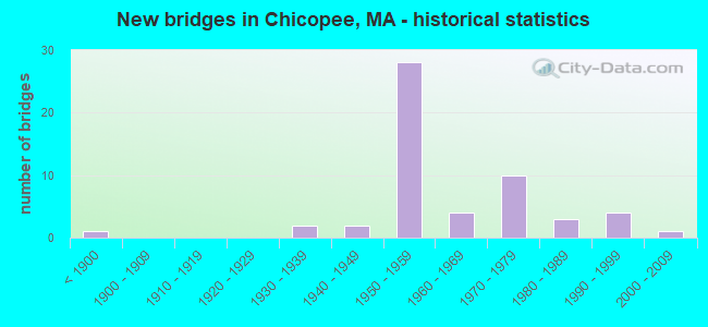
- New bridges - historical statistics
- 1Before 1900
- 21930-1939
- 21940-1949
- 281950-1959
- 41960-1969
- 101970-1979
- 31980-1989
- 41990-1999
- 12000-2009
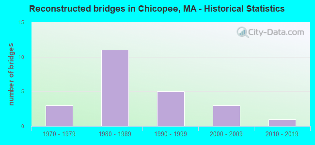
- Reconstructed bridges - Historical Statistics
- 31970-1979
- 111980-1989
- 51990-1999
- 32000-2009
- 12010-2019
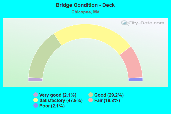
- Bridge Condition - Deck
- 2.1%Very good
- 29.2%Good
- 47.9%Satisfactory
- 18.8%Fair
- 2.1%Poor
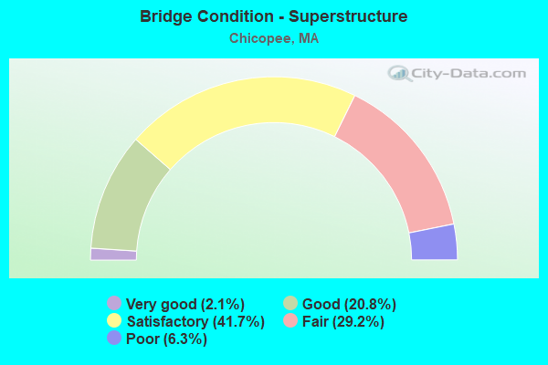
- Bridge Condition - Superstructure
- 2.1%Very good
- 20.8%Good
- 41.7%Satisfactory
- 29.2%Fair
- 6.3%Poor
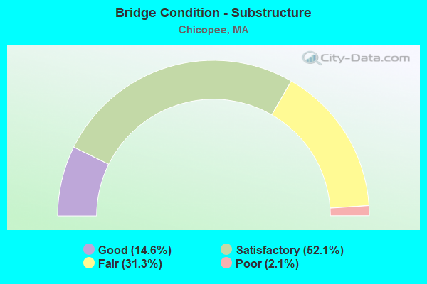
- Bridge Condition - Substructure
- 14.6%Good
- 52.1%Satisfactory
- 31.3%Fair
- 2.1%Poor
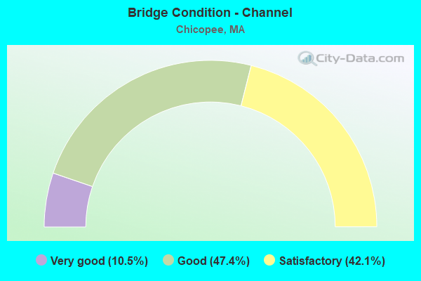
- Bridge Condition - Channel
- 10.5%Very good
- 47.4%Good
- 42.1%Satisfactory
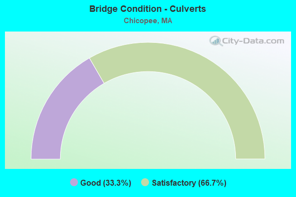
- Bridge Condition - Culverts
- 33.3%Good
- 66.7%Satisfactory
Find on map >> Show street view
Structure Number: C130440WJDOTNBI, Location: 1 M N JCT I-90 (Lat: 42.171583, Lng: -72.610192), Route carried "on" structure: Interstate 391, Year Built: 1978, Status: Open, Structure Length: 2.79m (9.15ft), Average Daily Traffic: 49,525 (year 2019), Truck Traffic: 6%, Average Future Daily Traffic: 51,112 (year 2032), Design Load: HS 20+Mod, Features Intersected: HWY MCKINSTRY AVE
Minimum Vertical Clearance: 30+ m (98+ ft), Kilometerpoint: 4.828, Lanes on structure: 6, Lanes under structure: 2, Base Highway Network: Yes, Owner: State Highway Agency, Approaching Roadway Width: 16.2m (53.1ft), Skew: 23 degrees, Material/Design: Steel, Design/Construction: Stringer/Multi-beam, Number Of Spans In Main Unit: 1, Length of Maximum Span: 25.9m (85.0ft), Curb-To-Curb Width: 16.1m (52.8ft), Out-to-Out Width: 33.9m (111.2ft)
Condition: Deck: Good, Superstructure: Satisfactory, Substructure: Good, Operating Rating: 73.8 metric tons, Method Used To Determine Operating Rating: Load Factor (LF), Inventory Rating: 44.2 metric tons, Method Used To Determine Inventory Rating: Load Factor (LF), Structural Evaluation: Equal to present minimum criteria, Deck Geometry: High priority of replacement, Underclear: High priority of corrective action, Approach Roadway Alignment: Equal to present desirable criteria, Length Of Structure Improvement: 2.80m (9.19ft), Designated Inspection Frequency: Every 24 months, Inspection Date: October 2021, Bridge Improvement Cost: $3,538,000, Roadway Improvement Cost: $354,000, Total Project Cost: $5,308,000 ( Estimate for 2022), Deck Structure Type: Concrete Cast-file-Place, Wearing Surface/Protective System: Wearing Surface: Bituminous, Membrane: Built-up
Find on map >> Show street view
Structure Number: C13045123DOTNBI, Location: MM 3.9 ON I-391 (Lat: 42.181278, Lng: -72.605508), Route carried "on" structure: State highway 141, Year Built: 1979, Status: Open, Structure Length: 6.41m (21.03ft), Average Daily Traffic: 10,800 (year 2000), Truck Traffic: 10%, Average Future Daily Traffic: 17,056 (year 2032), Design Load: HS 20+Mod, Features Intersected: I 391
Minimum Vertical Clearance: 30+ m (98+ ft), Kilometerpoint: 13.647, Lanes on structure: 5, Lanes under structure: 8, Base Highway Network: Yes, Owner: State Highway Agency, Approaching Roadway Width: 27.4m (89.9ft), Skew: 23 degrees, Material/Design: Steel continuous, Design/Construction: Stringer/Multi-beam, Number Of Spans In Main Unit: 2, Length of Maximum Span: 31.5m (103.3ft), Curb or Sidewalk Widths: Left: 0.2m (0.7ft), Right: 2.4m (7.9ft), Curb-To-Curb Width: 21.9m (71.9ft), Out-to-Out Width: 30.9m (101.4ft)
Condition: Deck: Good, Superstructure: Satisfactory, Substructure: Satisfactory, Operating Rating: 55.1 metric tons, Method Used To Determine Operating Rating: Load Factor (LF), Inventory Rating: 34.0 metric tons, Method Used To Determine Inventory Rating: Load Factor (LF), Structural Evaluation: Equal to present minimum criteria, Deck Geometry: Somewhat better than minimum adequacy, Underclear: High priority of corrective action, Approach Roadway Alignment: Equal to present desirable criteria, Length Of Structure Improvement: 6.50m (21.33ft), Designated Inspection Frequency: Every 24 months, Inspection Date: November 2021, Bridge Improvement Cost: $2,391,000, Roadway Improvement Cost: $240,000, Total Project Cost: $3,587,000 ( Estimate for 2022), Deck Structure Type: Concrete Cast-file-Place, Wearing Surface/Protective System: Wearing Surface: Bituminous, Membrane: Built-up
Find on map >> Show street view
Structure Number: C1304613VDOT634, Location: 850' E OF INT MEADOW ST (Lat: 42.182431, Lng: -72.607758), Route carried "on" structure: State highway 141, Year Built: 1979, Status: Open, Structure Length: 1.66m (5.45ft), Average Daily Traffic: 9,633 (year 2016), Average Future Daily Traffic: 17,056 (year 2032), Design Load: HS 20+Mod, Features Intersected: RR BMRR
Minimum Vertical Clearance: 30+ m (98+ ft), Kilometerpoint: 13.679, Lanes on structure: 4, Owner: State Highway Agency, Approaching Roadway Width: 28.0m (91.9ft), Skew: 20 degrees, Material/Design: Steel, Design/Construction: Stringer/Multi-beam, Number Of Spans In Main Unit: 1, Length of Maximum Span: 15.1m (49.5ft), Curb or Sidewalk Widths: Left: 0.3m (1.0ft), Right: 2.4m (7.9ft), Curb-To-Curb Width: 23.5m (77.1ft), Out-to-Out Width: 33.5m (109.9ft)
Condition: Deck: Good, Superstructure: Good, Substructure: Good, Operating Rating: 71.1 metric tons, Method Used To Determine Operating Rating: Load Factor (LF), Inventory Rating: 42.6 metric tons, Method Used To Determine Inventory Rating: Load Factor (LF), Structural Evaluation: Better than present minimum criteria, Deck Geometry: Superior to present desirable criteria, Underclear: Somewhat better than minimum adequacy, Approach Roadway Alignment: Equal to present desirable criteria, Length Of Structure Improvement: 1.70m (5.58ft), Designated Inspection Frequency: Every 24 months, Inspection Date: October 2021, Bridge Improvement Cost: $224,000, Roadway Improvement Cost: $23,000, Total Project Cost: $337,000 ( Estimate for 2022), Deck Structure Type: Concrete Cast-file-Place, Wearing Surface/Protective System: Wearing Surface: Monolithic Concrete
Find on map >> Show street view
Structure Number: C130470WQDOTNBI, Location: MM 4.0 ON I-391 (Lat: 42.184764, Lng: -72.606303), Route carried "on" structure: Interstate 391, Year Built: 1979, Status: Open, Structure Length: 2.40m (7.87ft), Average Daily Traffic: 35,948 (year 2015), Truck Traffic: 10%, Average Future Daily Traffic: 51,112 (year 2032), Design Load: HS 20+Mod, Features Intersected: RR BMRR
Minimum Vertical Clearance: 30+ m (98+ ft), Kilometerpoint: 5.995, Lanes on structure: 7, Base Highway Network: Yes, Owner: State Highway Agency, Approaching Roadway Width: 16.5m (54.1ft), Skew: 3 degrees, Material/Design: Steel, Design/Construction: Stringer/Multi-beam, Number Of Spans In Main Unit: 1, Length of Maximum Span: 22.2m (72.8ft), Curb-To-Curb Width: 28.0m (91.9ft), Out-to-Out Width: 46.5m (152.6ft)
Condition: Deck: Good, Superstructure: Good, Substructure: Satisfactory, Operating Rating: 77.3 metric tons, Method Used To Determine Operating Rating: Load Factor (LF), Inventory Rating: 46.3 metric tons, Method Used To Determine Inventory Rating: Load Factor (LF), Structural Evaluation: Equal to present minimum criteria, Deck Geometry: Somewhat better than minimum adequacy, Underclear: Somewhat better than minimum adequacy, Approach Roadway Alignment: Equal to present desirable criteria, Length Of Structure Improvement: 2.50m (8.20ft), Designated Inspection Frequency: Every 24 months, Inspection Date: October 2021, Bridge Improvement Cost: $1,226,000, Roadway Improvement Cost: $123,000, Total Project Cost: $1,840,000 ( Estimate for 2022), Deck Structure Type: Concrete Cast-file-Place, Wearing Surface/Protective System: Wearing Surface: Bituminous, Membrane: Built-up
Find on map >> Show street view
Structure Number: C130490WMDOTNBI, Location: MM 1.8 ON I-391 (Lat: 42.151917, Lng: -72.612300), Route carried "on" structure: Interstate 391, Year Built: 1979, Status: Open, Structure Length: 7.38m (24.21ft), Average Daily Traffic: 26,000 (year 2019), Truck Traffic: 10%, Average Future Daily Traffic: 65,688 (year 2031), Design Load: HS 20+Mod, Features Intersected: WATER N BR CHICOPEE RIV
Minimum Vertical Clearance: 30+ m (98+ ft), Kilometerpoint: 2.414, Lanes on structure: 7, Base Highway Network: Yes, Owner: State Highway Agency, Approaching Roadway Width: 32.2m (105.6ft), Skew: 30 degrees, Material/Design: Steel continuous, Design/Construction: Stringer/Multi-beam, Number Of Spans In Main Unit: 3, Length of Maximum Span: 27.4m (89.9ft), Curb-To-Curb Width: 32.2m (105.6ft), Out-to-Out Width: 33.9m (111.2ft)
Condition: Deck: Satisfactory, Superstructure: Satisfactory, Substructure: Fair, Channel: Good, Operating Rating: 52.1 metric tons, Method Used To Determine Operating Rating: Load Factor (LF), Inventory Rating: 31.2 metric tons, Method Used To Determine Inventory Rating: Load Factor (LF), Structural Evaluation: Somewhat better than minimum adequacy, Deck Geometry: Superior to present desirable criteria, Waterway Adequacy: Equal to present desirable criteria, Approach Roadway Alignment: Equal to present desirable criteria, Length Of Structure Improvement: 7.40m (24.28ft), Designated Inspection Frequency: Every 24 months, Inspection Date: January 2021, Bridge Improvement Cost: $9,854,000, Roadway Improvement Cost: $986,000, Total Project Cost: $14,782,000 ( Estimate for 2022), Deck Structure Type: Concrete Cast-file-Place, Wearing Surface/Protective System: Wearing Surface: Bituminous, Membrane: Built-up
Find on map >> Show street view
Structure Number: C130500WNDOTNBI, Location: 1.65 M N SPRINGFIELD C.L. (Lat: 42.151636, Lng: -72.611431), Route carried "on" structure: Ramp Interstate 391, Year Built: 1979, Status: Open, Structure Length: 8.72m (28.61ft), Average Daily Traffic: 4,725 (year 2019), Truck Traffic: 10%, Average Future Daily Traffic: 6,535 (year 2031), Design Load: HS 20+Mod, Features Intersected: WATER N BR CHICOPEE RIV
Minimum Vertical Clearance: 30+ m (98+ ft), Kilometerpoint: 2.414, Lanes on structure: 1, Base Highway Network: Yes, Owner: State Highway Agency, Approaching Roadway Width: 6.7m (22.0ft), Skew: 9 degrees, Material/Design: Steel continuous, Design/Construction: Stringer/Multi-beam, Number Of Spans In Main Unit: 3, Length of Maximum Span: 31.5m (103.3ft), Curb-To-Curb Width: 6.7m (22.0ft), Out-to-Out Width: 7.6m (24.9ft)
Condition: Deck: Satisfactory, Superstructure: Fair, Substructure: Fair, Channel: Good, Operating Rating: 63.8 metric tons, Method Used To Determine Operating Rating: Load Factor (LF), Inventory Rating: 38.2 metric tons, Method Used To Determine Inventory Rating: Load Factor (LF), Structural Evaluation: Somewhat better than minimum adequacy, Deck Geometry: Equal to present minimum criteria, Waterway Adequacy: Equal to present desirable criteria, Approach Roadway Alignment: Equal to present desirable criteria, Length Of Structure Improvement: 8.80m (28.87ft), Designated Inspection Frequency: Every 24 months, Inspection Date: Febuary 2021, Bridge Improvement Cost: $2,628,000, Roadway Improvement Cost: $263,000, Total Project Cost: $3,943,000 ( Estimate for 2022), Deck Structure Type: Concrete Cast-file-Place, Wearing Surface/Protective System: Wearing Surface: Bituminous, Membrane: Built-up
Find on map >> Show street view
Structure Number: C130524HYDOTNBI, Location: MM 49.0 ON I-90 EB (Lat: 42.169556, Lng: -72.580958), Route carried "on" structure: Interstate 90, Year Built: 1957, Year Reconstructed: 1994, Status: Open, Structure Length: 1.83m (6.00ft), Average Daily Traffic: 31,163 (year 2017), Truck Traffic: 12%, Average Future Daily Traffic: 51,060 (year 2032), Design Load: HS 20, Features Intersected: I 90 EXIT 49 RAMPS
Minimum Vertical Clearance: 30+ m (98+ ft), Kilometerpoint: 78.856, Lanes on structure: 2, Lanes under structure: 2, Base Highway Network: Yes, Toll: On toll road, Owner: State Highway Agency, Approaching Roadway Width: 17.7m (58.1ft), Material/Design: Steel, Design/Construction: Stringer/Multi-beam, Number Of Spans In Main Unit: 1, Length of Maximum Span: 16.8m (55.1ft), Curb-To-Curb Width: 17.7m (58.1ft), Out-to-Out Width: 19.6m (64.3ft)
Condition: Deck: Satisfactory, Superstructure: Satisfactory, Substructure: Satisfactory, Operating Rating: 55.1 metric tons, Method Used To Determine Operating Rating: Load Factor (LF), Inventory Rating: 33.0 metric tons, Method Used To Determine Inventory Rating: Load Factor (LF), Structural Evaluation: Equal to present minimum criteria, Deck Geometry: Superior to present desirable criteria, Underclear: High priority of corrective action, Approach Roadway Alignment: Equal to present desirable criteria, Length Of Structure Improvement: 1.90m (6.23ft), Designated Inspection Frequency: Every 24 months, Inspection Date: January 2021, Bridge Improvement Cost: $293,000, Roadway Improvement Cost: $30,000, Total Project Cost: $440,000 ( Estimate for 2022), Deck Structure Type: Concrete Cast-file-Place, Wearing Surface/Protective System: Wearing Surface: Bituminous, Membrane: Preformed Fabric, Deck Protection: Epoxy Coated Reinforcing
Find on map >> Show street view
Structure Number: C130524J0DOTNBI, Location: MM 49.0 ON I-90 WB (Lat: 42.169917, Lng: -72.580925), Route carried "on" structure: Interstate 90, Year Built: 1957, Year Reconstructed: 1994, Status: Open, Structure Length: 1.83m (6.00ft), Average Daily Traffic: 34,525 (year 2017), Truck Traffic: 12%, Average Future Daily Traffic: 51,060 (year 2032), Design Load: HS 20, Features Intersected: I 90 RAMPS INT 49
Minimum Vertical Clearance: 30+ m (98+ ft), Kilometerpoint: 78.856, Lanes on structure: 2, Lanes under structure: 2, Base Highway Network: Yes, Toll: On toll road, Owner: State Highway Agency, Approaching Roadway Width: 12.5m (41.0ft), Material/Design: Steel, Design/Construction: Stringer/Multi-beam, Number Of Spans In Main Unit: 1, Length of Maximum Span: 16.8m (55.1ft), Curb-To-Curb Width: 12.9m (42.3ft), Out-to-Out Width: 13.8m (45.3ft)
Condition: Deck: Satisfactory, Superstructure: Satisfactory, Substructure: Fair, Operating Rating: 54.2 metric tons, Method Used To Determine Operating Rating: Load Factor (LF), Inventory Rating: 32.5 metric tons, Method Used To Determine Inventory Rating: Load Factor (LF), Structural Evaluation: Somewhat better than minimum adequacy, Deck Geometry: Superior to present desirable criteria, Underclear: High priority of corrective action, Approach Roadway Alignment: Equal to present desirable criteria, Length Of Structure Improvement: 1.90m (6.23ft), Designated Inspection Frequency: Every 24 months, Inspection Date: January 2021, Bridge Improvement Cost: $1,030,000, Roadway Improvement Cost: $104,000, Total Project Cost: $1,546,000 ( Estimate for 2022), Deck Structure Type: Concrete Cast-file-Place, Wearing Surface/Protective System: Wearing Surface: Bituminous, Membrane: Preformed Fabric, Deck Protection: Epoxy Coated Reinforcing
Find on map >> Show street view
Structure Number: C130534HMDOTNBI, Location: MM 51.2 ON I-90 EB (Lat: 42.161383, Lng: -72.542100), Route carried "on" structure: Interstate 90, Year Built: 1957, Year Reconstructed: 1995, Status: Open, Structure Length: 1.83m (6.00ft), Average Daily Traffic: 32,675 (year 2017), Truck Traffic: 12%, Average Future Daily Traffic: 49,614 (year 2031), Design Load: HS 20+Mod, Features Intersected: I 90 EXIT 51 RAMPS
Minimum Vertical Clearance: 30+ m (98+ ft), Kilometerpoint: 82.235, Lanes on structure: 2, Lanes under structure: 2, Base Highway Network: Yes, Toll: On toll road, Owner: State Highway Agency, Approaching Roadway Width: 16.5m (54.1ft), Material/Design: Steel, Design/Construction: Stringer/Multi-beam, Number Of Spans In Main Unit: 1, Length of Maximum Span: 16.8m (55.1ft), Curb-To-Curb Width: 16.5m (54.1ft), Out-to-Out Width: 17.4m (57.1ft)
Condition: Deck: Satisfactory, Superstructure: Fair, Substructure: Satisfactory, Operating Rating: 57.1 metric tons, Method Used To Determine Operating Rating: Load Factor (LF), Inventory Rating: 34.2 metric tons, Method Used To Determine Inventory Rating: Load Factor (LF), Structural Evaluation: Somewhat better than minimum adequacy, Deck Geometry: Superior to present desirable criteria, Underclear: High priority of corrective action, Approach Roadway Alignment: Equal to present desirable criteria, Length Of Structure Improvement: 1.90m (6.23ft), Designated Inspection Frequency: Every 24 months, Inspection Date: June 2020, Bridge Improvement Cost: $1,299,000, Roadway Improvement Cost: $130,000, Total Project Cost: $1,949,000 ( Estimate for 2022), Deck Structure Type: Concrete Cast-file-Place, Wearing Surface/Protective System: Wearing Surface: Bituminous, Membrane: Preformed Fabric, Deck Protection: Epoxy Coated Reinforcing
Find on map >> Show street view
Structure Number: C130534HNDOTNBI, Location: MM 51.2 ON I-90 WB (Lat: 42.161722, Lng: -72.542033), Route carried "on" structure: Interstate 90, Year Built: 1957, Year Reconstructed: 1995, Status: Open, Structure Length: 1.83m (6.00ft), Average Daily Traffic: 25,031 (year 2017), Truck Traffic: 12%, Average Future Daily Traffic: 49,614 (year 2031), Design Load: HS 20+Mod, Features Intersected: I 90 EXIT 51 RAMPS
Minimum Vertical Clearance: 30+ m (98+ ft), Kilometerpoint: 82.235, Lanes on structure: 2, Lanes under structure: 2, Base Highway Network: Yes, Toll: On toll road, Owner: State Highway Agency, Approaching Roadway Width: 12.8m (42.0ft), Material/Design: Steel, Design/Construction: Stringer/Multi-beam, Number Of Spans In Main Unit: 1, Length of Maximum Span: 16.8m (55.1ft), Curb-To-Curb Width: 12.8m (42.0ft), Out-to-Out Width: 13.7m (44.9ft)
Condition: Deck: Satisfactory, Superstructure: Satisfactory, Substructure: Fair, Operating Rating: 54.2 metric tons, Method Used To Determine Operating Rating: Load Factor (LF), Inventory Rating: 32.5 metric tons, Method Used To Determine Inventory Rating: Load Factor (LF), Structural Evaluation: Somewhat better than minimum adequacy, Deck Geometry: Equal to present desirable criteria, Underclear: High priority of corrective action, Approach Roadway Alignment: Equal to present desirable criteria, Length Of Structure Improvement: 1.90m (6.23ft), Designated Inspection Frequency: Every 24 months, Inspection Date: June 2020, Bridge Improvement Cost: $1,023,000, Roadway Improvement Cost: $103,000, Total Project Cost: $1,535,000 ( Estimate for 2022), Deck Structure Type: Concrete Cast-file-Place, Wearing Surface/Protective System: Wearing Surface: Bituminous, Membrane: Preformed Fabric, Deck Protection: Epoxy Coated Reinforcing
Find on map >> Show street view
Structure Number: C13055AEYMUNNBI, Location: UNDER I391 @ DELTA PARK (Lat: 42.147253, Lng: -72.614117), Route carried "on" structure: City street , Year Built: 1997, Status: Open, Structure Length: 0.85m (2.79ft), Average Daily Traffic: 300 (year 2019), Truck Traffic: 5%, Average Future Daily Traffic: 1,579 (year 2032), Design Load: HS 20, Features Intersected: WATER DWIGHT MFG CANAL, Facility Carried by Structure: HWY DEPOT ST
Minimum Vertical Clearance: 30+ m (98+ ft), Kilometerpoint: 0.097, Lanes on structure: 2, Owner: City or Municipal Highway Agency, Approaching Roadway Width: 7.9m (25.9ft), Material/Design: Steel, Design/Construction: Stringer/Multi-beam, Number Of Spans In Main Unit: 1, Length of Maximum Span: 7.2m (23.6ft), Curb or Sidewalk Widths: Left: 0.0m, Right: 1.2m (3.9ft), Curb-To-Curb Width: 7.9m (25.9ft), Out-to-Out Width: 10.1m (33.1ft)
Condition: Deck: Satisfactory, Superstructure: Good, Substructure: Good, Channel: Good, Operating Rating: 63.5 metric tons, Method Used To Determine Operating Rating: Allowable Stress (AS), Inventory Rating: 41.1 metric tons, Method Used To Determine Inventory Rating: Allowable Stress (AS), Structural Evaluation: Better than present minimum criteria, Deck Geometry: Somewhat better than minimum adequacy, Waterway Adequacy: Equal to present desirable criteria, Approach Roadway Alignment: Equal to present minimum criteria, Length Of Structure Improvement: 0.90m (2.95ft), Designated Inspection Frequency: Every 24 months, Inspection Date: November 2021, Bridge Improvement Cost: $264,000, Roadway Improvement Cost: $27,000, Total Project Cost: $397,000 ( Estimate for 2022), Deck Structure Type: Concrete Cast-file-Place, Wearing Surface/Protective System: Wearing Surface: Latex Concrete, Deck Protection: Epoxy Coated Reinforcing
Find on map >> Show street view
Structure Number: C13056136DOTNBI, Location: 200' N JCT ST 141 (Lat: 42.158008, Lng: -72.549247), Route carried "on" structure: City street , Year Built: 1991, Status: Open, Structure Length: 10.76m (35.30ft), Average Daily Traffic: 18,620 (year 2015), Truck Traffic: 10%, Average Future Daily Traffic: 26,548 (year 2032), Design Load: HS 20, Features Intersected: WATER CHICOPEE RIVER, Facility Carried by Structure: HWY TECHNOLGY DR
Minimum Vertical Clearance: 30+ m (98+ ft), Kilometerpoint: 0.032, Lanes on structure: 4, Owner: State Highway Agency, Approaching Roadway Width: 19.5m (64.0ft), Skew: 3 degrees, Material/Design: Steel continuous, Design/Construction: Stringer/Multi-beam, Number Of Spans In Main Unit: 3, Length of Maximum Span: 67.1m (220.1ft), Curb or Sidewalk Widths: Left: 1.5m (4.9ft), Right: 1.5m (4.9ft), Curb-To-Curb Width: 19.5m (64.0ft), Out-to-Out Width: 23.4m (76.8ft)
Condition: Deck: Good, Superstructure: Good, Substructure: Satisfactory, Channel: Good, Operating Rating: 73.3 metric tons, Method Used To Determine Operating Rating: Load Factor (LF), Inventory Rating: 44.0 metric tons, Method Used To Determine Inventory Rating: Load Factor (LF), Structural Evaluation: Equal to present minimum criteria, Deck Geometry: Better than present minimum criteria, Waterway Adequacy: Superior to present desirable criteria, Approach Roadway Alignment: Equal to present desirable criteria, Length Of Structure Improvement: 10.80m (35.43ft), Designated Inspection Frequency: Every 24 months, Inspection Date: April 2021, Bridge Improvement Cost: $2,648,000, Roadway Improvement Cost: $265,000, Total Project Cost: $3,973,000 ( Estimate for 2022), Deck Structure Type: Concrete Cast-file-Place, Wearing Surface/Protective System: Wearing Surface: Bituminous, Membrane: Built-up, Deck Protection: Epoxy Coated Reinforcing
Find on map >> Show street view
Structure Number: C13057AHJMUNNBI, Location: 570' E OF CAREW ST (Lat: 42.155833, Lng: -72.557633), Route carried "on" structure: City street 141, Year Built: 1993, Status: Open, Structure Length: 0.68m (2.23ft), Average Daily Traffic: 9,698 (year 2015), Truck Traffic: 6%, Average Future Daily Traffic: 9,190 (year 2032), Features Intersected: WATER POOR BROOK
Minimum Vertical Clearance: 30+ m (98+ ft), Kilometerpoint: 0.000, Lanes on structure: 4, Owner: City or Municipal Highway Agency, Approaching Roadway Width: 15.8m (51.8ft), Skew: 1 degrees, Material/Design: Concrete, Design/Construction: Culvert, Number Of Spans In Main Unit: 2, Length of Maximum Span: 3.1m (10.2ft), Curb or Sidewalk Widths: Left: 0.0m, Right: 1.2m (3.9ft)
Condition: Channel: Satisfactory, Culverts: Satisfactory, Operating Rating: 88.3 metric tons, Method Used To Determine Operating Rating: Load Factor (LF), Inventory Rating: 52.9 metric tons, Method Used To Determine Inventory Rating: Load Factor (LF), Structural Evaluation: Equal to present minimum criteria, Waterway Adequacy: Equal to present minimum criteria, Approach Roadway Alignment: Better than present minimum criteria, Length Of Structure Improvement: 0.50m (1.64ft), Designated Inspection Frequency: Every 24 months, Inspection Date: June 2021, Bridge Improvement Cost: $316,000, Roadway Improvement Cost: $32,000, Total Project Cost: $475,000 ( Estimate for 2022), Wearing Surface/Protective System: Wearing Surface: Bituminous
Find on map >> Show street view
Structure Number: C13058AHHMUNNBI, Location: .8 M E OF SHERIDAN STREET (Lat: 42.162428, Lng: -72.560425), Route carried "on" structure: City street , Year Built: 1958, Status: Open, Structure Length: 1.72m (5.64ft), Average Daily Traffic: 13,664 (year 2018), Truck Traffic: 5%, Average Future Daily Traffic: 28,999 (year 2032), Features Intersected: WATER COOLEY BROOK, Facility Carried by Structure: HWY FULLER RD
Minimum Vertical Clearance: 30+ m (98+ ft), Kilometerpoint: 0.000, Lanes on structure: 2, Owner: City or Municipal Highway Agency, Approaching Roadway Width: 9.1m (29.9ft), Skew: 4 degrees, Material/Design: Concrete, Design/Construction: Culvert, Number Of Spans In Main Unit: 5, Length of Maximum Span: 2.5m (8.2ft)
Condition: Channel: Satisfactory, Culverts: Satisfactory, Structural Evaluation: Equal to present minimum criteria, Waterway Adequacy: Equal to present desirable criteria, Approach Roadway Alignment: Equal to present desirable criteria, Length Of Structure Improvement: 0.60m (1.97ft), Designated Inspection Frequency: Every 24 months, Inspection Date: April 2021, Bridge Improvement Cost: $724,000, Roadway Improvement Cost: $73,000, Total Project Cost: $1,087,000 ( Estimate for 2022), Wearing Surface/Protective System: Wearing Surface: Bituminous
Find on map >> Show street view
Structure Number: G090130LHMUNNBI, Location: .6 MI E OF S HADLEY LINE (Lat: 42.221717, Lng: -72.536575), Route carried "on" structure: City street , Year Built: 1940, Status: Open, Structure Length: 1.89m (6.20ft), Average Daily Traffic: 8,000 (year 2018), Truck Traffic: 13%, Average Future Daily Traffic: 10,897 (year 2031), Design Load: H 20, Features Intersected: WATER STONY BROOK, Facility Carried by Structure: HWY NEW LDLOW RD
Minimum Vertical Clearance: 30+ m (98+ ft), Kilometerpoint: 0.821, Lanes on structure: 2, Owner: Town or Township Highway Agency, Approaching Roadway Width: 13.4m (44.0ft), Material/Design: Concrete continuous, Design/Construction: Slab, Number Of Spans In Main Unit: 3, Length of Maximum Span: 6.1m (20.0ft), Curb or Sidewalk Widths: Left: 0.2m (0.7ft), Right: 0.2m (0.7ft), Curb-To-Curb Width: 13.4m (44.0ft), Out-to-Out Width: 14.5m (47.6ft)
Condition: Deck: Fair, Superstructure: Fair, Substructure: Fair, Channel: Good, Operating Rating: 51.1 metric tons, Method Used To Determine Operating Rating: Load Factor (LF), Inventory Rating: 30.6 metric tons, Method Used To Determine Inventory Rating: Load Factor (LF), Structural Evaluation: Somewhat better than minimum adequacy, Deck Geometry: Equal to present minimum criteria, Waterway Adequacy: Better than present minimum criteria, Approach Roadway Alignment: Equal to present desirable criteria, Length Of Structure Improvement: 1.90m (6.23ft), Designated Inspection Frequency: Every 24 months, Underwater Inspection Frequency: Every 36 months, Inspection Date: December 2020, Underwater Inspection Date: August 2020, Bridge Improvement Cost: $1,083,000, Roadway Improvement Cost: $109,000, Total Project Cost: $1,625,000 ( Estimate for 2022), Deck Structure Type: Concrete Cast-file-Place, Wearing Surface/Protective System: Wearing Surface: Bituminous
Find on map >> Show street view
Structure Number: C130524HYDOTNBI, Location: .2MI.S.LOMBARD RD (Lat: 42.166667, Lng: -72.583333), Route carried "under" structure: Ramp Interstate 90, Year Built: 1957, Structure Length: 0. m, Average Daily Traffic: 2,483 (year 0000), Features Intersected: I 90 EB RAMP OFF INTR 5
Minimum Vertical Clearance: 4.32m (14.17ft), Kilometerpoint: 78.856, Lanes on structure: 2, Lanes under structure: 2, Toll: On toll road, Material/Design: Steel, Design/Construction: Stringer/Multi-beam, Length of Maximum Span: 16.8m (55.1ft)
Find on map >> Show street view
Structure Number: C130524J0DOTNBI, Location: .2MI.S.LOMBARD RD (Lat: 42.166667, Lng: -72.583333), Route carried "under" structure: Ramp Interstate 90, Year Built: 1957, Structure Length: 0. m, Average Daily Traffic: 2,345 (year 0000), Features Intersected: I 90 EB RAMP OFF INTR 5
Minimum Vertical Clearance: 4.32m (14.17ft), Kilometerpoint: 78.856, Lanes on structure: 2, Lanes under structure: 2, Toll: On toll road, Material/Design: Steel, Design/Construction: Stringer/Multi-beam, Length of Maximum Span: 16.8m (55.1ft)
Find on map >> Show street view
Structure Number: C130534HMDOTNBI, Location: .2MI.S.LOMBARD RD (Lat: 42.166667, Lng: -72.550000), Route carried "under" structure: Ramp Interstate 90, Year Built: 1957, Structure Length: 0. m, Average Daily Traffic: 1,853 (year 0000), Features Intersected: I 90 EB RAMPS INTRCNG 6
Minimum Vertical Clearance: 4.32m (14.17ft), Kilometerpoint: 82.235, Lanes on structure: 2, Lanes under structure: 2, Toll: On toll road, Material/Design: Steel, Design/Construction: Stringer/Multi-beam, Length of Maximum Span: 16.8m (55.1ft)
Find on map >> Show street view
Structure Number: C130534HNDOTNBI, Location: .2MI.S.LOMBARD RD (Lat: 42.166667, Lng: -72.550000), Route carried "under" structure: Ramp Interstate 90, Year Built: 1957, Structure Length: 0. m, Average Daily Traffic: 6,659 (year 0000), Features Intersected: I 90 EB RAMPS INTRCNG 6
Minimum Vertical Clearance: 4.32m (14.17ft), Kilometerpoint: 82.235, Lanes on structure: 2, Lanes under structure: 2, Toll: On toll road, Material/Design: Steel, Design/Construction: Stringer/Multi-beam, Length of Maximum Span: 16.8m (55.1ft)