Bridge Statistics for Clifton, New Jersey (NJ)
Condition, Traffic, Stress, Structural Evaluation, Project Costs
- National Bridge Inventory (NBI) Statistics
- 172Number of bridges
- 1,657ft / 505mTotal length
- $37,940,000Total costs
- 7,940,171Total average daily traffic
- 238,955Total average daily truck traffic
- National Bridge Inventory (NBI) Registered Bridges for Clifton
- No street view available for this location
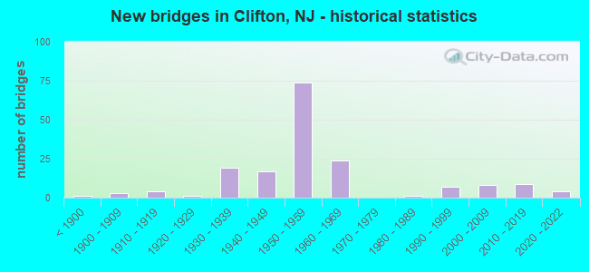
- New bridges - historical statistics
- 1Before 1900
- 31900-1909
- 41910-1919
- 11920-1929
- 191930-1939
- 171940-1949
- 741950-1959
- 241960-1969
- 11980-1989
- 71990-1999
- 82000-2009
- 92010-2019
- 42020-2022
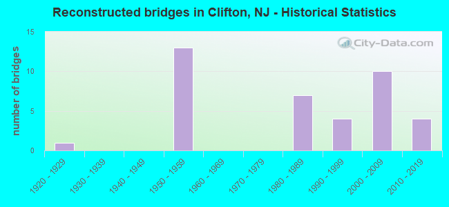
- Reconstructed bridges - Historical Statistics
- 11920-1929
- 01930-1939
- 01940-1949
- 131950-1959
- 01960-1969
- 01970-1979
- 71980-1989
- 41990-1999
- 102000-2009
- 42010-2019
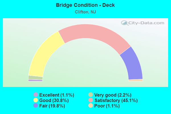
- Bridge Condition - Deck
- 1.1%Excellent
- 2.2%Very good
- 30.8%Good
- 45.1%Satisfactory
- 19.8%Fair
- 1.1%Poor
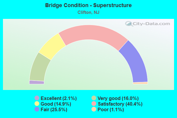
- Bridge Condition - Superstructure
- 2.1%Excellent
- 16.0%Very good
- 14.9%Good
- 40.4%Satisfactory
- 25.5%Fair
- 1.1%Poor
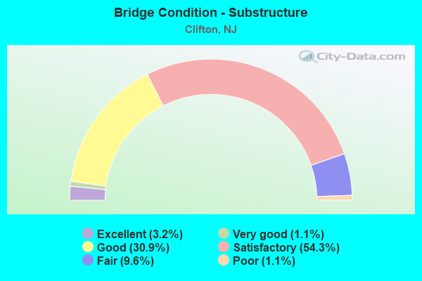
- Bridge Condition - Substructure
- 3.2%Excellent
- 1.1%Very good
- 30.9%Good
- 54.3%Satisfactory
- 9.6%Fair
- 1.1%Poor
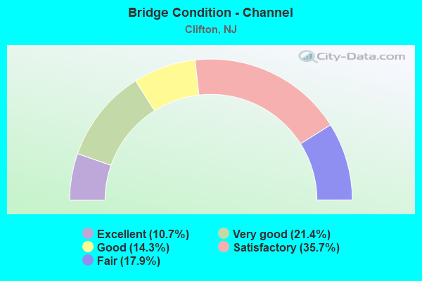
- Bridge Condition - Channel
- 10.7%Excellent
- 21.4%Very good
- 14.3%Good
- 35.7%Satisfactory
- 17.9%Fair
Find on map >> Show street view
Structure Number: 160005, Location: 2.5 MI NE OF RT 3 INTER (Lat: 40.861800, Lng: -74.119931), Route carried "on" structure: City street , Year Built: 1892, Year Reconstructed: 1994, Status: Open, Structure Length: 1.25m (4.10ft), Average Daily Traffic: 17,355 (year 2021), Truck Traffic: 4%, Average Future Daily Traffic: 23,380 (year 2041), Design Load: HS 20, Features Intersected: WEASEL BROOK, Facility Carried by Structure: PASSAIC STREET
Minimum Vertical Clearance: 30+ m (98+ ft), Kilometerpoint: 2.511, Lanes on structure: 2, Owner: County Highway Agency, Approaching Roadway Width: 9.8m (32.2ft), Material/Design: Masonry, Design/Construction: Arch - Deck, Number Of Spans In Main Unit: 1, Length of Maximum Span: 12.5m (41.0ft), Curb or Sidewalk Widths: Left: 2.0m (6.6ft), Right: 3.5m (11.5ft), Curb-To-Curb Width: 9.9m (32.5ft), Out-to-Out Width: 16.7m (54.8ft)
Condition: Superstructure: Satisfactory, Substructure: Satisfactory, Channel: Fair, Operating Rating: 54.4 metric tons, Method Used To Determine Operating Rating: Field evaluation and documented engineering judgment, Inventory Rating: 32.7 metric tons, Method Used To Determine Inventory Rating: Field evaluation and documented engineering judgment, Structural Evaluation: Equal to present minimum criteria, Deck Geometry: Meets minimum limits, Waterway Adequacy: Superior to present desirable criteria, Approach Roadway Alignment: Equal to present minimum criteria, Designated Inspection Frequency: Every 24 months, Inspection Date: May 2021
Find on map >> Show street view
Structure Number: 1600056, Location: 85FT N OF HIGHLAND AV/626 (Lat: 40.873761, Lng: -74.125981), Route carried "on" structure: City street , Year Built: 1931, Year Reconstructed: 2010, Status: Open, Structure Length: 0.88m (2.89ft), Average Daily Traffic: 1,645 (year 2021), Truck Traffic: 1%, Average Future Daily Traffic: 2,220 (year 2041), Design Load: HS 25 or greater, Features Intersected: WEASEL BROOK, Facility Carried by Structure: DAVIDSON STREET
Minimum Vertical Clearance: 30+ m (98+ ft), Kilometerpoint: 0.000, Lanes on structure: 1, Owner: County Highway Agency, Approaching Roadway Width: 7.3m (24.0ft), Material/Design: Prestressed concrete, Design/Construction: Slab, Number Of Spans In Main Unit: 1, Length of Maximum Span: 7.9m (25.9ft), Curb or Sidewalk Widths: Left: 1.6m (5.2ft), Right: 1.7m (5.6ft), Curb-To-Curb Width: 7.3m (24.0ft), Out-to-Out Width: 12.0m (39.4ft)
Condition: Deck: Satisfactory, Superstructure: Good, Substructure: Satisfactory, Channel: Fair, Inventory Rating: 59.0 metric tons, Method Used To Determine Inventory Rating: Load Factor (LF), Structural Evaluation: Equal to present minimum criteria, Deck Geometry: Meets minimum limits, Waterway Adequacy: Superior to present desirable criteria, Approach Roadway Alignment: Equal to present desirable criteria, Designated Inspection Frequency: Every 24 months, Inspection Date: April 2021, Deck Structure Type: Concrete Cast-file-Place, Wearing Surface/Protective System: Wearing Surface: Monolithic Concrete, Deck Protection: Epoxy Coated Reinforcing
Find on map >> Show street view
Structure Number: 1600057, Location: 100FT N OF HIGHLND AV/626 (Lat: 40.873439, Lng: -74.126819), Route carried "on" structure: City street , Year Built: 1916, Year Reconstructed: 2009, Status: Open, Structure Length: 0.94m (3.08ft), Average Daily Traffic: 3,275 (year 2021), Truck Traffic: 1%, Average Future Daily Traffic: 4,420 (year 2041), Design Load: HS 20+Mod, Features Intersected: WEASEL BROOK, Facility Carried by Structure: HOPE AVENUE
Minimum Vertical Clearance: 30+ m (98+ ft), Kilometerpoint: 0.000, Lanes on structure: 2, Owner: County Highway Agency, Approaching Roadway Width: 11.9m (39.0ft), Skew: 2 degrees, Material/Design: Prestressed concrete, Design/Construction: Slab, Number Of Spans In Main Unit: 1, Length of Maximum Span: 8.2m (26.9ft), Curb or Sidewalk Widths: Left: 3.7m (12.1ft), Right: 3.4m (11.2ft), Curb-To-Curb Width: 12.0m (39.4ft), Out-to-Out Width: 20.2m (66.3ft)
Condition: Deck: Satisfactory, Superstructure: Satisfactory, Substructure: Satisfactory, Channel: Satisfactory, Inventory Rating: 53.5 metric tons, Method Used To Determine Inventory Rating: Load Factor (LF), Structural Evaluation: Equal to present minimum criteria, Deck Geometry: Somewhat better than minimum adequacy, Waterway Adequacy: Superior to present desirable criteria, Approach Roadway Alignment: Equal to present desirable criteria, Designated Inspection Frequency: Every 24 months, Inspection Date: April 2021, Deck Structure Type: Concrete Cast-file-Place, Wearing Surface/Protective System: Deck Protection: Epoxy Coated Reinforcing
Find on map >> Show street view
Structure Number: 1600058, Location: 0.1 E OF LEXINGTN AV(625) (Lat: 40.873589, Lng: -74.128639), Route carried "on" structure: City street , Year Built: 1952, Status: Open, Structure Length: 0.76m (2.49ft), Average Daily Traffic: 3,510 (year 2021), Truck Traffic: 1%, Average Future Daily Traffic: 4,730 (year 2041), Features Intersected: WEASEL BROOK, Facility Carried by Structure: LAKE AVENUE
Minimum Vertical Clearance: 30+ m (98+ ft), Kilometerpoint: 0.000, Lanes on structure: 2, Owner: County Highway Agency, Approaching Roadway Width: 11.0m (36.1ft), Material/Design: Steel, Design/Construction: Stringer/Multi-beam, Number Of Spans In Main Unit: 1, Length of Maximum Span: 6.4m (21.0ft), Curb or Sidewalk Widths: Left: 3.2m (10.5ft), Right: 3.2m (10.5ft), Curb-To-Curb Width: 11.0m (36.1ft), Out-to-Out Width: 18.3m (60.0ft)
Condition: Deck: Satisfactory, Superstructure: Fair, Substructure: Satisfactory, Channel: Satisfactory, Operating Rating: 62.6 metric tons, Method Used To Determine Operating Rating: Load Factor (LF), Inventory Rating: 37.2 metric tons, Method Used To Determine Inventory Rating: Load Factor (LF), Structural Evaluation: Somewhat better than minimum adequacy, Deck Geometry: Somewhat better than minimum adequacy, Waterway Adequacy: Better than present minimum criteria, Approach Roadway Alignment: Equal to present desirable criteria, Designated Inspection Frequency: Every 24 months, Inspection Date: April 2021, Deck Structure Type: Concrete Cast-file-Place, Wearing Surface/Protective System: Wearing Surface: Bituminous
Find on map >> Show street view
Structure Number: 1600059, Location: 0.1 E OF LEXINGTON AV/625 (Lat: 40.874050, Lng: -74.129250), Route carried "on" structure: City street , Year Built: 1914, Year Reconstructed: 2007, Status: Open, Structure Length: 0.94m (3.08ft), Average Daily Traffic: 3,990 (year 2021), Truck Traffic: 1%, Average Future Daily Traffic: 5,380 (year 2041), Design Load: HS 25 or greater, Features Intersected: WEASEL BROOK, Facility Carried by Structure: CENTER STREET
Minimum Vertical Clearance: 30+ m (98+ ft), Kilometerpoint: 0.000, Lanes on structure: 2, Owner: County Highway Agency, Approaching Roadway Width: 10.1m (33.1ft), Skew: 2 degrees, Material/Design: Steel, Design/Construction: Stringer/Multi-beam, Number Of Spans In Main Unit: 1, Length of Maximum Span: 8.2m (26.9ft), Curb or Sidewalk Widths: Left: 2.4m (7.9ft), Right: 2.4m (7.9ft), Curb-To-Curb Width: 10.1m (33.1ft), Out-to-Out Width: 15.2m (49.9ft)
Condition: Deck: Good, Superstructure: Very good, Substructure: Good, Channel: Very good, Inventory Rating: 86.2 metric tons, Method Used To Determine Inventory Rating: Load Factor (LF), Structural Evaluation: Better than present minimum criteria, Deck Geometry: Meets minimum limits, Waterway Adequacy: Superior to present desirable criteria, Approach Roadway Alignment: Equal to present desirable criteria, Designated Inspection Frequency: Every 24 months, Inspection Date: April 2021, Deck Structure Type: Concrete Cast-file-Place, Wearing Surface/Protective System: Wearing Surface: Monolithic Concrete, Membrane: Epoxy, Deck Protection: Galvanized Reinforcing
Find on map >> Show street view
Structure Number: 160006, Location: 0.42 MI. SOUTH OF RT 46. (Lat: 40.874119, Lng: -74.131019), Route carried "on" structure: County highway 625, Year Built: 1905, Year Reconstructed: 1998, Status: Open, Structure Length: 0.88m (2.89ft), Average Daily Traffic: 13,000 (year 2021), Truck Traffic: 4%, Average Future Daily Traffic: 17,510 (year 2041), Design Load: HS 20+Mod, Features Intersected: WEASEL BROOK, Facility Carried by Structure: LEXINGTON AVE.
Minimum Vertical Clearance: 30+ m (98+ ft), Kilometerpoint: 1.416, Lanes on structure: 2, Owner: County Highway Agency, Approaching Roadway Width: 12.2m (40.0ft), Material/Design: Prestressed concrete, Design/Construction: Slab, Number Of Spans In Main Unit: 1, Length of Maximum Span: 8.2m (26.9ft), Curb or Sidewalk Widths: Left: 4.0m (13.1ft), Right: 3.4m (11.2ft), Curb-To-Curb Width: 12.2m (40.0ft), Out-to-Out Width: 20.5m (67.3ft)
Condition: Deck: Satisfactory, Superstructure: Satisfactory, Substructure: Satisfactory, Channel: Very good, Inventory Rating: 79.8 metric tons, Method Used To Determine Inventory Rating: Load Factor (LF), Structural Evaluation: Equal to present minimum criteria, Deck Geometry: Somewhat better than minimum adequacy, Waterway Adequacy: Superior to present desirable criteria, Approach Roadway Alignment: Equal to present desirable criteria, Designated Inspection Frequency: Every 24 months, Inspection Date: April 2021, Deck Structure Type: Concrete Cast-file-Place, Wearing Surface/Protective System: Wearing Surface: Monolithic Concrete, Deck Protection: Epoxy Coated Reinforcing
Find on map >> Show street view
Structure Number: 1600061, Location: 0.9 MI. S. OF ROUTE 46 (Lat: 40.873250, Lng: -74.133411), Route carried "on" structure: County highway 624, Year Built: 1911, Year Reconstructed: 2000, Status: Open, Structure Length: 0.91m (2.99ft), Average Daily Traffic: 16,525 (year 2021), Truck Traffic: 4%, Average Future Daily Traffic: 22,260 (year 2041), Design Load: HS 20+Mod, Features Intersected: WEASEL BROOK
Minimum Vertical Clearance: 30+ m (98+ ft), Kilometerpoint: 1.255, Lanes on structure: 2, Owner: County Highway Agency, Approaching Roadway Width: 12.8m (42.0ft), Material/Design: Prestressed concrete, Design/Construction: Slab, Number Of Spans In Main Unit: 1, Length of Maximum Span: 7.6m (24.9ft), Curb or Sidewalk Widths: Left: 2.2m (7.2ft), Right: 2.5m (8.2ft), Curb-To-Curb Width: 12.8m (42.0ft), Out-to-Out Width: 18.2m (59.7ft)
Condition: Deck: Satisfactory, Superstructure: Good, Substructure: Satisfactory, Channel: Very good, Structural Evaluation: Equal to present minimum criteria, Deck Geometry: Somewhat better than minimum adequacy, Waterway Adequacy: Superior to present desirable criteria, Approach Roadway Alignment: Equal to present minimum criteria, Designated Inspection Frequency: Every 24 months, Inspection Date: April 2021, Deck Structure Type: Concrete Cast-file-Place, Wearing Surface/Protective System: Wearing Surface: Monolithic Concrete, Deck Protection: Epoxy Coated Reinforcing
Find on map >> Show street view
Structure Number: 1600062, Location: 0.1 MI NW OF HIGHLAND AVE (Lat: 40.871611, Lng: -74.136231), Route carried "on" structure: County highway 601, Year Built: 1903, Year Reconstructed: 1995, Status: Open, Structure Length: 0.94m (3.08ft), Average Daily Traffic: 12,490 (year 2021), Truck Traffic: 4%, Average Future Daily Traffic: 15,240 (year 2041), Design Load: HS 25 or greater, Features Intersected: WEASEL BROOK, Facility Carried by Structure: MAIN AVE
Minimum Vertical Clearance: 30+ m (98+ ft), Kilometerpoint: 5.874, Lanes on structure: 2, Base Highway Network: Yes, Owner: County Highway Agency, Approaching Roadway Width: 13.4m (44.0ft), Material/Design: Prestressed concrete, Design/Construction: Slab, Number Of Spans In Main Unit: 1, Length of Maximum Span: 7.9m (25.9ft), Curb or Sidewalk Widths: Left: 3.0m (9.8ft), Right: 3.7m (12.1ft), Curb-To-Curb Width: 13.4m (44.0ft), Out-to-Out Width: 20.4m (66.9ft)
Condition: Deck: Good, Superstructure: Good, Substructure: Good, Channel: Very good, Operating Rating: 89.8 metric tons, Method Used To Determine Operating Rating: Load Factor (LF), Inventory Rating: 89.8 metric tons, Method Used To Determine Inventory Rating: Load Factor (LF), Structural Evaluation: Better than present minimum criteria, Deck Geometry: Equal to present minimum criteria, Waterway Adequacy: Better than present minimum criteria, Approach Roadway Alignment: Equal to present desirable criteria, Designated Inspection Frequency: Every 24 months, Inspection Date: April 2021, Deck Structure Type: Concrete Cast-file-Place, Wearing Surface/Protective System: Wearing Surface: Monolithic Concrete, Deck Protection: Epoxy Coated Reinforcing
Find on map >> Show street view
Structure Number: 1600063, Location: 0.25 S OF CLIFTON AV(611) (Lat: 40.870900, Lng: -74.141719), Route carried "on" structure: City street , Year Built: 1919, Year Reconstructed: 2007, Status: Open, Structure Length: 1.07m (3.51ft), Average Daily Traffic: 2,610 (year 2021), Truck Traffic: 1%, Average Future Daily Traffic: 3,520 (year 2041), Design Load: HS 20+Mod, Features Intersected: WEASEL BROOK, Facility Carried by Structure: SECOND STREET
Minimum Vertical Clearance: 30+ m (98+ ft), Kilometerpoint: 0.000, Lanes on structure: 2, Owner: County Highway Agency, Approaching Roadway Width: 14.6m (47.9ft), Skew: 3 degrees, Material/Design: Steel, Design/Construction: Stringer/Multi-beam, Number Of Spans In Main Unit: 1, Length of Maximum Span: 9.4m (30.8ft), Curb or Sidewalk Widths: Left: 4.7m (15.4ft), Right: 4.3m (14.1ft), Curb-To-Curb Width: 14.6m (47.9ft), Out-to-Out Width: 24.1m (79.1ft)
Condition: Deck: Good, Superstructure: Good, Substructure: Satisfactory, Channel: Very good, Structural Evaluation: Equal to present minimum criteria, Deck Geometry: Superior to present desirable criteria, Waterway Adequacy: Equal to present desirable criteria, Approach Roadway Alignment: Equal to present desirable criteria, Designated Inspection Frequency: Every 24 months, Inspection Date: April 2021, Deck Structure Type: Concrete Cast-file-Place, Wearing Surface/Protective System: Wearing Surface: Monolithic Concrete, Membrane: Epoxy, Deck Protection: Galvanized Reinforcing
Find on map >> Show street view
Structure Number: 1600064, Location: 0.25 S OF CLIFTON AV(611) (Lat: 40.871011, Lng: -74.144461), Route carried "on" structure: City street , Year Built: 1938, Status: Open, Structure Length: 0.73m (2.40ft), Average Daily Traffic: 4,005 (year 2021), Truck Traffic: 3%, Average Future Daily Traffic: 5,400 (year 2041), Features Intersected: WEASEL BROOK, Facility Carried by Structure: THIRD STREET
Minimum Vertical Clearance: 30+ m (98+ ft), Kilometerpoint: 0.000, Lanes on structure: 2, Owner: County Highway Agency, Approaching Roadway Width: 11.0m (36.1ft), Material/Design: Steel, Design/Construction: Stringer/Multi-beam, Number Of Spans In Main Unit: 1, Length of Maximum Span: 6.4m (21.0ft), Curb or Sidewalk Widths: Left: 3.3m (10.8ft), Right: 3.3m (10.8ft), Curb-To-Curb Width: 11.0m (36.1ft), Out-to-Out Width: 18.3m (60.0ft)
Condition: Deck: Fair, Superstructure: Satisfactory, Substructure: Fair, Channel: Satisfactory, Operating Rating: 71.7 metric tons, Method Used To Determine Operating Rating: Load Factor (LF), Inventory Rating: 42.6 metric tons, Method Used To Determine Inventory Rating: Load Factor (LF), Structural Evaluation: Somewhat better than minimum adequacy, Deck Geometry: Somewhat better than minimum adequacy, Waterway Adequacy: Better than present minimum criteria, Approach Roadway Alignment: Equal to present desirable criteria, Designated Inspection Frequency: Every 24 months, Inspection Date: April 2021, Deck Structure Type: Concrete Cast-file-Place, Wearing Surface/Protective System: Wearing Surface: Bituminous
Find on map >> Show street view
Structure Number: 160008, Location: 0.1 MI S.OF RT.3 (Lat: 40.825911, Lng: -74.133231), Route carried "on" structure: County highway 624, Year Built: 1998, Status: Open, Structure Length: 3.17m (10.40ft), Average Daily Traffic: 6,485 (year 2021), Truck Traffic: 3%, Average Future Daily Traffic: 8,740 (year 2041), Design Load: HS 20+Mod, Features Intersected: Third River
Minimum Vertical Clearance: 30+ m (98+ ft), Kilometerpoint: 0.435, Lanes on structure: 2, Owner: County Highway Agency, Approaching Roadway Width: 13.4m (44.0ft), Skew: 3 degrees, Material/Design: Prestressed concrete, Design/Construction: Stringer/Multi-beam, Number Of Spans In Main Unit: 1, Length of Maximum Span: 29.0m (95.1ft), Curb or Sidewalk Widths: Left: 1.8m (5.9ft), Right: 1.8m (5.9ft), Curb-To-Curb Width: 13.4m (44.0ft), Out-to-Out Width: 17.7m (58.1ft)
Condition: Deck: Good, Superstructure: Very good, Substructure: Good, Channel: Good, Operating Rating: 73.5 metric tons, Method Used To Determine Operating Rating: Load Factor (LF), Inventory Rating: 44.5 metric tons, Method Used To Determine Inventory Rating: Load Factor (LF), Structural Evaluation: Better than present minimum criteria, Deck Geometry: Equal to present minimum criteria, Waterway Adequacy: Equal to present minimum criteria, Approach Roadway Alignment: Equal to present minimum criteria, Designated Inspection Frequency: Every 24 months, Inspection Date: March 2021, Deck Structure Type: Concrete Cast-file-Place, Wearing Surface/Protective System: Wearing Surface: Monolithic Concrete, Deck Protection: Epoxy Coated Reinforcing
Find on map >> Show street view
Structure Number: 1600081, Location: 0.2 MI NW OF WASH AVE. (Lat: 40.826739, Lng: -74.141581), Route carried "on" structure: State highway 7, Year Built: 1900, Year Reconstructed: 1925, Status: Closed, Structure Length: 1.07m (3.51ft), Average Daily Traffic: 9,385 (year 2021), Truck Traffic: 4%, Average Future Daily Traffic: 12,650 (year 2041), Features Intersected: THIRD RIVER
Minimum Vertical Clearance: 30+ m (98+ ft), Kilometerpoint: 15.128, Lanes on structure: 2, Owner: County Highway Agency, Approaching Roadway Width: 9.1m (29.9ft), Material/Design: Masonry, Design/Construction: Arch - Deck, Number Of Spans In Main Unit: 1, Length of Maximum Span: 10.7m (35.1ft), Curb or Sidewalk Widths: Left: 2.8m (9.2ft), Right: 2.7m (8.9ft), Curb-To-Curb Width: 9.1m (29.9ft), Out-to-Out Width: 15.2m (49.9ft)
Condition: Deck: Fair, Superstructure: Poor, Substructure: Poor, Channel: Fair, Operating Rating: 28.1 metric tons, Method Used To Determine Operating Rating: Load Factor (LF), Inventory Rating: 17.2 metric tons, Method Used To Determine Inventory Rating: Load Factor (LF), Structural Evaluation: Meets minimum limits, Deck Geometry: High priority of corrective action, Waterway Adequacy: High priority of corrective action, Approach Roadway Alignment: Equal to present minimum criteria, Length Of Structure Improvement: 1.60m (5.25ft), Designated Inspection Frequency: Every 24 months, Inspection Date: March 2021, Bridge Improvement Cost: $788,000, Roadway Improvement Cost: $100,000, Total Project Cost: $1,408,000 ( Estimate for 2017), Deck Structure Type: Concrete Cast-file-Place, Wearing Surface/Protective System: Wearing Surface: Bituminous
Find on map >> Show street view
Structure Number: 1600083, Location: 0.4 mi S of Rt 3 (Lat: 40.849739, Lng: -74.180519), Route carried "on" structure: County highway 509, Year Built: 1981, Status: Open, Structure Length: 1.16m (3.81ft), Average Daily Traffic: 15,325 (year 2021), Truck Traffic: 4%, Average Future Daily Traffic: 20,650 (year 2041), Features Intersected: Third River
Minimum Vertical Clearance: 30+ m (98+ ft), Kilometerpoint: 43.662, Lanes on structure: 2, Owner: County Highway Agency, Approaching Roadway Width: 14.6m (47.9ft), Skew: 1 degrees, Material/Design: Concrete continuous, Design/Construction: Culvert, Number Of Spans In Main Unit: 2, Length of Maximum Span: 5.5m (18.0ft), Curb-To-Curb Width: 14.6m (47.9ft), Out-to-Out Width: 15.5m (50.9ft)
Condition: Channel: Satisfactory, Culverts: Good, Operating Rating: 34.5 metric tons, Method Used To Determine Operating Rating: Load Factor (LF), Inventory Rating: 20.9 metric tons, Method Used To Determine Inventory Rating: Load Factor (LF), Structural Evaluation: Somewhat better than minimum adequacy, Deck Geometry: Superior to present desirable criteria, Waterway Adequacy: Better than present minimum criteria, Approach Roadway Alignment: Equal to present desirable criteria, Designated Inspection Frequency: Every 24 months, Inspection Date: March 2021, Deck Structure Type: Concrete Cast-file-Place, Wearing Surface/Protective System: Wearing Surface: Bituminous
Find on map >> Show street view
Structure Number: 160115, Location: 0.5 MI SE OF 3-46 JCT (Lat: 40.865289, Lng: -74.182319), Route carried "on" structure: County highway 623, Year Built: 1948, Status: Open, Structure Length: 3.84m (12.60ft), Average Daily Traffic: 12,872 (year 2020), Truck Traffic: 4%, Average Future Daily Traffic: 15,706 (year 2040), Design Load: H 20, Features Intersected: NJ RT 3, Facility Carried by Structure: GROVE STREET
Minimum Vertical Clearance: 30+ m (98+ ft), Kilometerpoint: 1.416, Lanes on structure: 2, Lanes under structure: 6, Owner: State Highway Agency, Approaching Roadway Width: 12.2m (40.0ft), Skew: 2 degrees, Material/Design: Steel, Design/Construction: Stringer/Multi-beam, Number Of Spans In Main Unit: 2, Length of Maximum Span: 18.3m (60.0ft), Curb or Sidewalk Widths: Left: 2.0m (6.6ft), Right: 1.9m (6.2ft), Curb-To-Curb Width: 12.2m (40.0ft), Out-to-Out Width: 16.7m (54.8ft)
Condition: Deck: Fair, Superstructure: Fair, Substructure: Fair, Operating Rating: 68.9 metric tons, Method Used To Determine Operating Rating: Load Factor (LF), Inventory Rating: 40.8 metric tons, Method Used To Determine Inventory Rating: Load Factor (LF), Structural Evaluation: Somewhat better than minimum adequacy, Deck Geometry: Somewhat better than minimum adequacy, Underclear: High priority of corrective action, Approach Roadway Alignment: Equal to present desirable criteria, Length Of Structure Improvement: 4.60m (15.09ft), Designated Inspection Frequency: Every 24 months, Inspection Date: May 2020, Bridge Improvement Cost: $37,000, Roadway Improvement Cost: $2,000, Total Project Cost: $55,000 ( Estimate for 2020), Deck Structure Type: Concrete Cast-file-Place, Wearing Surface/Protective System: Wearing Surface: Monolithic Concrete
Find on map >> Show street view
Structure Number: 1601151, Location: 1.3 MI SE OF 3-46 JCT (Lat: 40.855119, Lng: -74.178100), Route carried "on" structure: State highway 3, Year Built: 1945, Year Reconstructed: 1959, Status: Open, Structure Length: 3.08m (10.10ft), Average Daily Traffic: 138,586 (year 2020), Truck Traffic: 5%, Average Future Daily Traffic: 169,101 (year 2040), Design Load: HS 20, Features Intersected: BROAD ST (CO. 509)
Minimum Vertical Clearance: 30+ m (98+ ft), Kilometerpoint: 2.028, Lanes on structure: 8, Lanes under structure: 6, Base Highway Network: Yes, Owner: State Highway Agency, Approaching Roadway Width: 37.2m (122.0ft), Skew: 32 degrees, Material/Design: Steel, Design/Construction: Stringer/Multi-beam, Number Of Spans In Main Unit: 2, Length of Maximum Span: 14.6m (47.9ft), Curb or Sidewalk Widths: Left: 1.8m (5.9ft), Right: 1.8m (5.9ft), Curb-To-Curb Width: 37.2m (122.0ft), Out-to-Out Width: 42.8m (140.4ft)
Condition: Deck: Satisfactory, Superstructure: Satisfactory, Substructure: Satisfactory, Operating Rating: 49.9 metric tons, Method Used To Determine Operating Rating: Load Factor (LF), Inventory Rating: 29.9 metric tons, Method Used To Determine Inventory Rating: Load Factor (LF), Structural Evaluation: Equal to present minimum criteria, Deck Geometry: Superior to present desirable criteria, Underclear: Meets minimum limits, Approach Roadway Alignment: Equal to present desirable criteria, Designated Inspection Frequency: Every 24 months, Inspection Date: May 2020, Deck Structure Type: Concrete Cast-file-Place, Wearing Surface/Protective System: Wearing Surface: Bituminous
Find on map >> Show street view
Structure Number: 1601152, Location: 1.8 Mi. E of RT 46 Junc. (Lat: 40.848989, Lng: -74.172581), Route carried "on" structure: City street , Year Built: 1950, Status: Open, Structure Length: 4.02m (13.19ft), Average Daily Traffic: 2,240 (year 2020), Truck Traffic: 1%, Average Future Daily Traffic: 2,700 (year 2040), Design Load: HS 20, Features Intersected: NJ 3, Facility Carried by Structure: HEPBURN ROAD
Minimum Vertical Clearance: 30+ m (98+ ft), Kilometerpoint: 0.000, Lanes on structure: 2, Lanes under structure: 7, Owner: State Highway Agency, Approaching Roadway Width: 9.1m (29.9ft), Skew: 2 degrees, Material/Design: Steel, Design/Construction: Stringer/Multi-beam, Number Of Spans In Main Unit: 2, Length of Maximum Span: 19.2m (63.0ft), Curb or Sidewalk Widths: Left: 1.8m (5.9ft), Right: 1.8m (5.9ft), Curb-To-Curb Width: 9.1m (29.9ft), Out-to-Out Width: 13.4m (44.0ft)
Condition: Deck: Fair, Superstructure: Fair, Substructure: Satisfactory, Operating Rating: 65.3 metric tons, Method Used To Determine Operating Rating: Load Factor (LF), Inventory Rating: 39.0 metric tons, Method Used To Determine Inventory Rating: Load Factor (LF), Structural Evaluation: Somewhat better than minimum adequacy, Deck Geometry: Meets minimum limits, Underclear: High priority of replacement, Approach Roadway Alignment: Equal to present desirable criteria, Length Of Structure Improvement: 4.88m (16.01ft), Designated Inspection Frequency: Every 24 months, Inspection Date: April 2020, Bridge Improvement Cost: $2,288,000, Roadway Improvement Cost: $560,000, Total Project Cost: $4,151,000 ( Estimate for 2020), Deck Structure Type: Concrete Cast-file-Place, Wearing Surface/Protective System: Wearing Surface: Bituminous
Find on map >> Show street view
Structure Number: 1601153, Location: 2.6 MI SE OF 3-46 JCT (Lat: 40.840361, Lng: -74.161319), Route carried "on" structure: State highway 3, Year Built: 1948, Year Reconstructed: 1959, Status: Open, Structure Length: 1.74m (5.71ft), Average Daily Traffic: 138,586 (year 2020), Truck Traffic: 5%, Average Future Daily Traffic: 169,101 (year 2040), Design Load: HS 20, Features Intersected: BLOOMFIELD AVE (CR 622)
Minimum Vertical Clearance: 30+ m (98+ ft), Kilometerpoint: 4.249, Lanes on structure: 8, Lanes under structure: 2, Base Highway Network: Yes, Owner: State Highway Agency, Approaching Roadway Width: 32.9m (107.9ft), Skew: 30 degrees, Material/Design: Steel, Design/Construction: Stringer/Multi-beam, Number Of Spans In Main Unit: 1, Length of Maximum Span: 16.5m (54.1ft), Curb or Sidewalk Widths: Left: 1.8m (5.9ft), Right: 1.8m (5.9ft), Curb-To-Curb Width: 32.9m (107.9ft), Out-to-Out Width: 42.8m (140.4ft)
Condition: Deck: Satisfactory, Superstructure: Satisfactory, Substructure: Satisfactory, Operating Rating: 53.5 metric tons, Method Used To Determine Operating Rating: Load Factor (LF), Inventory Rating: 31.8 metric tons, Method Used To Determine Inventory Rating: Load Factor (LF), Structural Evaluation: Equal to present minimum criteria, Deck Geometry: Meets minimum limits, Underclear: Equal to present minimum criteria, Approach Roadway Alignment: Equal to present desirable criteria, Designated Inspection Frequency: Every 24 months, Inspection Date: April 2020, Deck Structure Type: Concrete Cast-file-Place, Wearing Surface/Protective System: Wearing Surface: Bituminous
Find on map >> Show street view
Structure Number: 1601154, Location: 2.8 MI SE OF 3-46 JCT (Lat: 40.838861, Lng: -74.158200), Route carried "on" structure: State highway 3, Year Built: 1948, Status: Open, Structure Length: 3.84m (12.60ft), Average Daily Traffic: 138,586 (year 2020), Truck Traffic: 5%, Average Future Daily Traffic: 169,101 (year 2040), Design Load: HS 20, Features Intersected: NORFOLK SOUTHERN
Minimum Vertical Clearance: 30+ m (98+ ft), Kilometerpoint: 4.571, Lanes on structure: 6, Base Highway Network: Yes, Owner: State Highway Agency, Approaching Roadway Width: 29.9m (98.1ft), Skew: 32 degrees, Material/Design: Steel, Design/Construction: Stringer/Multi-beam, Number Of Spans In Main Unit: 3, Length of Maximum Span: 11.9m (39.0ft), Curb or Sidewalk Widths: Left: 1.8m (5.9ft), Right: 1.8m (5.9ft), Curb-To-Curb Width: 29.9m (98.1ft), Out-to-Out Width: 35.0m (114.8ft)
Condition: Deck: Fair, Superstructure: Satisfactory, Substructure: Satisfactory, Operating Rating: 58.1 metric tons, Method Used To Determine Operating Rating: Load Factor (LF), Inventory Rating: 34.5 metric tons, Method Used To Determine Inventory Rating: Load Factor (LF), Structural Evaluation: Equal to present minimum criteria, Deck Geometry: Superior to present desirable criteria, Underclear: Somewhat better than minimum adequacy, Approach Roadway Alignment: Equal to present desirable criteria, Designated Inspection Frequency: Every 24 months, Inspection Date: May 2020, Deck Structure Type: Concrete Cast-file-Place, Wearing Surface/Protective System: Wearing Surface: Bituminous
Find on map >> Show street view
Structure Number: 1601155, Location: 1.5 MI NW OF 3-21 JCT (Lat: 40.834550, Lng: -74.148369), Route carried "on" structure: State highway 3, Year Built: 1948, Status: Open, Structure Length: 2.13m (6.99ft), Average Daily Traffic: 138,586 (year 2020), Truck Traffic: 5%, Average Future Daily Traffic: 169,101 (year 2040), Design Load: HS 20, Features Intersected: PASSAIC AVENUE (CR 603)
Minimum Vertical Clearance: 30+ m (98+ ft), Kilometerpoint: 5.504, Lanes on structure: 6, Lanes under structure: 2, Base Highway Network: Yes, Owner: State Highway Agency, Approaching Roadway Width: 29.9m (98.1ft), Skew: 30 degrees, Material/Design: Steel, Design/Construction: Stringer/Multi-beam, Number Of Spans In Main Unit: 1, Length of Maximum Span: 20.4m (66.9ft), Curb or Sidewalk Widths: Left: 1.8m (5.9ft), Right: 1.8m (5.9ft), Curb-To-Curb Width: 29.9m (98.1ft), Out-to-Out Width: 34.9m (114.5ft)
Condition: Deck: Satisfactory, Superstructure: Satisfactory, Substructure: Fair, Operating Rating: 59.9 metric tons, Method Used To Determine Operating Rating: Load Factor (LF), Inventory Rating: 36.3 metric tons, Method Used To Determine Inventory Rating: Load Factor (LF), Structural Evaluation: Somewhat better than minimum adequacy, Deck Geometry: Superior to present desirable criteria, Underclear: Equal to present minimum criteria, Approach Roadway Alignment: Equal to present desirable criteria, Designated Inspection Frequency: Every 24 months, Inspection Date: April 2020, Deck Structure Type: Concrete Cast-file-Place, Wearing Surface/Protective System: Wearing Surface: Bituminous
Find on map >> Show street view
Structure Number: 1601156, Location: 1.1 MI NW OF 3-21 JCT (Lat: 40.831531, Lng: -74.141719), Route carried "on" structure: State highway 3, Year Built: 1948, Year Reconstructed: 1996, Status: Open, Structure Length: 2.19m (7.19ft), Average Daily Traffic: 138,586 (year 2020), Truck Traffic: 5%, Average Future Daily Traffic: 169,101 (year 2040), Design Load: HS 20, Features Intersected: MAIN AVE (CR 601)
Minimum Vertical Clearance: 30+ m (98+ ft), Kilometerpoint: 6.148, Lanes on structure: 6, Lanes under structure: 4, Base Highway Network: Yes, Owner: State Highway Agency, Approaching Roadway Width: 29.9m (98.1ft), Skew: 31 degrees, Material/Design: Steel, Design/Construction: Stringer/Multi-beam, Number Of Spans In Main Unit: 1, Length of Maximum Span: 21.3m (69.9ft), Curb or Sidewalk Widths: Left: 1.7m (5.6ft), Right: 1.7m (5.6ft), Curb-To-Curb Width: 29.7m (97.4ft), Out-to-Out Width: 34.9m (114.5ft)
Condition: Deck: Satisfactory, Superstructure: Satisfactory, Substructure: Satisfactory, Operating Rating: 53.5 metric tons, Method Used To Determine Operating Rating: Load Factor (LF), Inventory Rating: 31.8 metric tons, Method Used To Determine Inventory Rating: Load Factor (LF), Structural Evaluation: Equal to present minimum criteria, Deck Geometry: Superior to present desirable criteria, Underclear: Meets minimum limits, Approach Roadway Alignment: Equal to present desirable criteria, Designated Inspection Frequency: Every 24 months, Inspection Date: April 2020, Deck Structure Type: Concrete Cast-file-Place, Wearing Surface/Protective System: Wearing Surface: Bituminous
Find on map >> Show street view
Structure Number: 1601157, Location: 1.0 MI NW OF 3-21 JCT (Lat: 40.830981, Lng: -74.140531), Route carried "on" structure: State highway 3, Year Built: 1947, Year Reconstructed: 2012, Status: Open, Structure Length: 1.22m (4.00ft), Average Daily Traffic: 138,586 (year 2020), Truck Traffic: 5%, Average Future Daily Traffic: 169,101 (year 2040), Design Load: HS 20, Features Intersected: THIRD RIVER
Minimum Vertical Clearance: 30+ m (98+ ft), Kilometerpoint: 6.293, Lanes on structure: 8, Base Highway Network: Yes, Owner: State Highway Agency, Approaching Roadway Width: 37.8m (124.0ft), Skew: 31 degrees, Material/Design: Concrete, Design/Construction: Culvert, Number Of Spans In Main Unit: 1, Length of Maximum Span: 12.2m (40.0ft), Curb-To-Curb Width: 36.6m (120.1ft), Out-to-Out Width: 49.7m (163.1ft)
Condition: Channel: Fair, Culverts: Good, Operating Rating: 81.6 metric tons, Method Used To Determine Operating Rating: Load Factor (LF), Inventory Rating: 49.0 metric tons, Method Used To Determine Inventory Rating: Load Factor (LF), Structural Evaluation: Better than present minimum criteria, Deck Geometry: Better than present minimum criteria, Waterway Adequacy: Superior to present desirable criteria, Approach Roadway Alignment: Equal to present desirable criteria, Designated Inspection Frequency: Every 24 months, Inspection Date: April 2020
Find on map >> Show street view
Structure Number: 160116, Location: 0.6 MI NW OF 3-21 JCT (Lat: 40.827061, Lng: -74.132850), Route carried "on" structure: State highway 3, Year Built: 1947, Year Reconstructed: 2012, Status: Open, Structure Length: 1.68m (5.51ft), Average Daily Traffic: 138,586 (year 2020), Truck Traffic: 5%, Average Future Daily Traffic: 169,101 (year 2040), Design Load: HS 20, Features Intersected: UPPER POND SPILLWAY
Minimum Vertical Clearance: 30+ m (98+ ft), Kilometerpoint: 7.065, Lanes on structure: 8, Base Highway Network: Yes, Owner: State Highway Agency, Approaching Roadway Width: 30.2m (99.1ft), Skew: 33 degrees, Material/Design: Concrete, Design/Construction: Culvert, Number Of Spans In Main Unit: 1, Length of Maximum Span: 16.8m (55.1ft)
Condition: Channel: Fair, Culverts: Good, Structural Evaluation: Better than present minimum criteria, Waterway Adequacy: Superior to present desirable criteria, Approach Roadway Alignment: Equal to present desirable criteria, Designated Inspection Frequency: Every 24 months, Inspection Date: April 2020
Find on map >> Show street view
Structure Number: 1601161, Location: 0.5 MI NW OF 3-21 JCT (Lat: 40.827000, Lng: -74.132081), Route carried "on" structure: State highway 3, Year Built: 1947, Year Reconstructed: 2014, Status: Open, Structure Length: 1.86m (6.10ft), Average Daily Traffic: 138,586 (year 2020), Truck Traffic: 5%, Average Future Daily Traffic: 169,101 (year 2040), Design Load: HL 93, Features Intersected: RIVER RD (CR 624)
Minimum Vertical Clearance: 30+ m (98+ ft), Kilometerpoint: 7.113, Lanes on structure: 9, Lanes under structure: 2, Base Highway Network: Yes, Owner: State Highway Agency, Approaching Roadway Width: 40.5m (132.9ft), Skew: 30 degrees, Material/Design: Prestressed concrete, Design/Construction: Tee Beam, Number Of Spans In Main Unit: 1, Length of Maximum Span: 17.1m (56.1ft), Curb-To-Curb Width: 41.2m (135.2ft), Out-to-Out Width: 43.3m (142.1ft)
Condition: Deck: Good, Superstructure: Very good, Substructure: Good, Operating Rating: 84.2 metric tons, Method Used To Determine Operating Rating: Load and Resistance Factor Rating (LRFR) rating reported by rating factor(RF) method using HL-93 loadings, Inventory Rating: 56.1 metric tons, Method Used To Determine Inventory Rating: Load and Resistance Factor Rating (LRFR) rating reported by rating factor(RF) method using HL-93 loadings, Structural Evaluation: Better than present minimum criteria, Deck Geometry: Superior to present desirable criteria, Underclear: Equal to present minimum criteria, Approach Roadway Alignment: Equal to present desirable criteria, Designated Inspection Frequency: Every 24 months, Inspection Date: April 2020, Deck Structure Type: Concrete Cast-file-Place, Wearing Surface/Protective System: Deck Protection: Epoxy Coated Reinforcing
Find on map >> Show street view
Structure Number: 1601162, Location: 0.3 MI NW OF 3-21 JCT (Lat: 40.825211, Lng: -74.128989), Route carried "on" structure: State highway 3, Year Built: 2014, Status: Open, Structure Length: 5.52m (18.11ft), Average Daily Traffic: 138,586 (year 2020), Truck Traffic: 5%, Average Future Daily Traffic: 169,101 (year 2040), Design Load: HL 93, Features Intersected: NJ TRANSIT & SERVICE RD
Minimum Vertical Clearance: 30+ m (98+ ft), Kilometerpoint: 7.467, Lanes on structure: 9, Base Highway Network: Yes, Owner: State Highway Agency, Approaching Roadway Width: 47.7m (156.5ft), Skew: 35 degrees, Material/Design: Steel, Design/Construction: Stringer/Multi-beam, Number Of Spans In Main Unit: 1, Length of Maximum Span: 54.3m (178.1ft), Curb-To-Curb Width: 47.7m (156.5ft), Out-to-Out Width: 50.1m (164.4ft)
Condition: Deck: Good, Superstructure: Very good, Substructure: Good, Operating Rating: 66.4 metric tons, Method Used To Determine Operating Rating: Load and Resistance Factor Rating (LRFR) rating reported by rating factor(RF) method using HL-93 loadings, Inventory Rating: 51.2 metric tons, Method Used To Determine Inventory Rating: Load and Resistance Factor Rating (LRFR) rating reported by rating factor(RF) method using HL-93 loadings, Structural Evaluation: Better than present minimum criteria, Deck Geometry: Superior to present desirable criteria, Underclear: Somewhat better than minimum adequacy, Approach Roadway Alignment: Equal to present minimum criteria, Designated Inspection Frequency: Every 24 months, Inspection Date: May 2020, Deck Structure Type: Concrete Cast-file-Place, Wearing Surface/Protective System: Wearing Surface: Latex Concrete, Deck Protection: Epoxy Coated Reinforcing
Find on map >> Show street view
Structure Number: 1601163, Location: 0.2 MI NW OF 3-21 JCT (Lat: 40.824761, Lng: -74.128231), Route carried "on" structure: State highway 3, Year Built: 2014, Status: Open, Structure Length: 2.07m (6.79ft), Average Daily Traffic: 138,586 (year 2020), Truck Traffic: 5%, Average Future Daily Traffic: 169,101 (year 2040), Design Load: HL 93, Features Intersected: RT 21 RAMP & RT 3 RAMP
Minimum Vertical Clearance: 30+ m (98+ ft), Kilometerpoint: 7.564, Lanes on structure: 9, Lanes under structure: 3, Base Highway Network: Yes, Owner: State Highway Agency, Approaching Roadway Width: 52.0m (170.6ft), Skew: 30 degrees, Material/Design: Prestressed concrete, Design/Construction: Tee Beam, Number Of Spans In Main Unit: 1, Length of Maximum Span: 19.8m (65.0ft), Curb-To-Curb Width: 49.5m (162.4ft), Out-to-Out Width: 52.1m (170.9ft)
Condition: Deck: Good, Superstructure: Very good, Substructure: Very good, Operating Rating: 74.2 metric tons, Method Used To Determine Operating Rating: Load and Resistance Factor Rating (LRFR) rating reported by rating factor(RF) method using HL-93 loadings, Inventory Rating: 42.8 metric tons, Method Used To Determine Inventory Rating: Load and Resistance Factor Rating (LRFR) rating reported by rating factor(RF) method using HL-93 loadings, Structural Evaluation: Equal to present desirable criteria, Deck Geometry: Superior to present desirable criteria, Underclear: High priority of corrective action, Approach Roadway Alignment: Better than present minimum criteria, Designated Inspection Frequency: Every 24 months, Inspection Date: April 2020, Roadway Improvement Cost: $26,000, Total Project Cost: $30,000 ( Estimate for 2020), Deck Structure Type: Concrete Cast-file-Place, Wearing Surface/Protective System: Deck Protection: Epoxy Coated Reinforcing
Find on map >> Show street view
Structure Number: 1601164, Location: RT 3,RT 21,PASSAIC R jun. (Lat: 40.823361, Lng: -74.125250), Route carried "on" structure: State highway 3, Year Built: 2014, Status: Open, Structure Length: 23.01m (75.49ft), Average Daily Traffic: 139,960 (year 2020), Truck Traffic: 5%, Average Future Daily Traffic: 170,775 (year 2040), Design Load: HL 93, Features Intersected: PASSAIC RV, 21, 3, CR507
Minimum Vertical Clearance: 5.94m (19.49ft), Kilometerpoint: 7.870, Lanes on structure: 10, Lanes under structure: 11, Base Highway Network: Yes, Owner: State Highway Agency, Approaching Roadway Width: 58.1m (190.6ft), Skew: 30 degrees, Navigation Control: Yes ( Vertical Clearance: 9.1m (29.9ft), Horizontal Clearance: 40.5m (132.9ft)), Material/Design: Steel, Design/Construction: Stringer/Multi-beam, Number Of Spans In Main Unit: 6, Length of Maximum Span: 44.2m (145.0ft), Curb-To-Curb Width: 58.1m (190.6ft), Out-to-Out Width: 61.1m (200.5ft)
Condition: Deck: Good, Superstructure: Very good, Substructure: Excellent, Channel: Excellent, Operating Rating: 46.3 metric tons, Method Used To Determine Operating Rating: Load and Resistance Factor Rating (LRFR) rating reported by rating factor(RF) method using HL-93 loadings, Inventory Rating: 35.6 metric tons, Method Used To Determine Inventory Rating: Load and Resistance Factor Rating (LRFR) rating reported by rating factor(RF) method using HL-93 loadings, Structural Evaluation: Equal to present desirable criteria, Deck Geometry: Superior to present desirable criteria, Underclear: Meets minimum limits, Waterway Adequacy: Superior to present desirable criteria, Approach Roadway Alignment: Superior to present desirable criteria, Designated Inspection Frequency: Every 24 months, Underwater Inspection Frequency: Every 48 months, Inspection Date: July 2020, Underwater Inspection Date: October 2018, Deck Structure Type: Concrete Cast-file-Place, Wearing Surface/Protective System: Wearing Surface: Monolithic Concrete, Deck Protection: Epoxy Coated Reinforcing
Find on map >> Show street view
Structure Number: 1602001, Location: 0.25 W OF MAIN AVE(CR601) (Lat: 40.870950, Lng: -74.140239), Route carried "on" structure: City street , Year Built: 1956, Status: Open, Structure Length: 1.01m (3.31ft), Average Daily Traffic: 13,380 (year 2021), Truck Traffic: 1%, Average Future Daily Traffic: 18,030 (year 2041), Features Intersected: WEASEL BROOK, Facility Carried by Structure: SYLVAN AVENUE
Minimum Vertical Clearance: 30+ m (98+ ft), Kilometerpoint: 0.000, Lanes on structure: 2, Owner: City or Municipal Highway Agency, Approaching Roadway Width: 11.0m (36.1ft), Skew: 4 degrees, Material/Design: Steel, Design/Construction: Stringer/Multi-beam, Number Of Spans In Main Unit: 1, Length of Maximum Span: 8.8m (28.9ft), Curb or Sidewalk Widths: Left: 3.7m (12.1ft), Right: 3.1m (10.2ft), Curb-To-Curb Width: 11.0m (36.1ft), Out-to-Out Width: 17.8m (58.4ft)
Condition: Deck: Fair, Superstructure: Good, Substructure: Good, Channel: Good, Operating Rating: 54.4 metric tons, Method Used To Determine Operating Rating: Field evaluation and documented engineering judgment, Inventory Rating: 32.7 metric tons, Method Used To Determine Inventory Rating: Field evaluation and documented engineering judgment, Structural Evaluation: Better than present minimum criteria, Deck Geometry: Meets minimum limits, Waterway Adequacy: Equal to present desirable criteria, Approach Roadway Alignment: Equal to present desirable criteria, Designated Inspection Frequency: Every 24 months, Inspection Date: April 2021, Deck Structure Type: Concrete Cast-file-Place, Wearing Surface/Protective System: Wearing Surface: Monolithic Concrete
Find on map >> Show street view
Structure Number: 1602002, Location: 0.2 W OF MAIN AVE (CR601) (Lat: 40.870881, Lng: -74.139869), Route carried "on" structure: City street , Year Built: 1956, Status: Open, Structure Length: 0.73m (2.40ft), Average Daily Traffic: 1,025 (year 2021), Truck Traffic: 1%, Average Future Daily Traffic: 1,390 (year 2041), Features Intersected: WEASEL BROOK, Facility Carried by Structure: WILSON STREET
Minimum Vertical Clearance: 30+ m (98+ ft), Kilometerpoint: 0.000, Lanes on structure: 2, Owner: City or Municipal Highway Agency, Approaching Roadway Width: 9.1m (29.9ft), Material/Design: Steel, Design/Construction: Stringer/Multi-beam, Number Of Spans In Main Unit: 1, Length of Maximum Span: 6.1m (20.0ft), Curb or Sidewalk Widths: Left: 3.1m (10.2ft), Right: 2.0m (6.6ft), Curb-To-Curb Width: 9.1m (29.9ft), Out-to-Out Width: 14.7m (48.2ft)
Condition: Deck: Good, Superstructure: Good, Substructure: Good, Channel: Good, Operating Rating: 49.0 metric tons, Method Used To Determine Operating Rating: Load Factor (LF), Inventory Rating: 29.0 metric tons, Method Used To Determine Inventory Rating: Load Factor (LF), Structural Evaluation: Better than present minimum criteria, Deck Geometry: Somewhat better than minimum adequacy, Waterway Adequacy: Equal to present desirable criteria, Approach Roadway Alignment: Equal to present desirable criteria, Designated Inspection Frequency: Every 24 months, Inspection Date: April 2021, Deck Structure Type: Concrete Cast-file-Place, Wearing Surface/Protective System: Wearing Surface: Bituminous
Find on map >> Show street view
Structure Number: 1602003, Location: 0.1 W OF MAIN AVE (CR601) (Lat: 40.871339, Lng: -74.137611), Route carried "on" structure: City street , Year Built: 1956, Status: Open, Structure Length: 0.67m (2.20ft), Average Daily Traffic: 1,025 (year 2021), Truck Traffic: 1%, Average Future Daily Traffic: 1,390 (year 2041), Features Intersected: WEASEL BROOK, Facility Carried by Structure: FEDERAL STREET
Minimum Vertical Clearance: 30+ m (98+ ft), Kilometerpoint: 0.000, Lanes on structure: 2, Owner: City or Municipal Highway Agency, Approaching Roadway Width: 9.1m (29.9ft), Material/Design: Steel, Design/Construction: Stringer/Multi-beam, Number Of Spans In Main Unit: 1, Length of Maximum Span: 6.1m (20.0ft), Curb or Sidewalk Widths: Left: 2.6m (8.5ft), Right: 2.7m (8.9ft), Curb-To-Curb Width: 9.1m (29.9ft), Out-to-Out Width: 15.2m (49.9ft)
Condition: Deck: Satisfactory, Superstructure: Good, Substructure: Satisfactory, Channel: Satisfactory, Operating Rating: 54.4 metric tons, Method Used To Determine Operating Rating: Field evaluation and documented engineering judgment, Inventory Rating: 32.7 metric tons, Method Used To Determine Inventory Rating: Field evaluation and documented engineering judgment, Structural Evaluation: Equal to present minimum criteria, Deck Geometry: Somewhat better than minimum adequacy, Waterway Adequacy: Equal to present desirable criteria, Approach Roadway Alignment: Equal to present minimum criteria, Designated Inspection Frequency: Every 24 months, Inspection Date: April 2021, Deck Structure Type: Concrete Cast-file-Place, Wearing Surface/Protective System: Wearing Surface: Bituminous
Find on map >> Show street view
Structure Number: 1602151, Location: 1 MILE NORTH OF RT 80 (Lat: 40.916919, Lng: -74.132411), Route carried "on" structure: Ramp State highway 4, Year Built: 1960, Status: Open, Structure Length: 4.72m (15.49ft), Average Daily Traffic: 10,100 (year 2020), Truck Traffic: 4%, Average Future Daily Traffic: 12,100 (year 2040), Design Load: HS 20+Mod, Features Intersected: NJ 20 SOUTHBOUND
Minimum Vertical Clearance: 30+ m (98+ ft), Kilometerpoint: 0.129, Lanes on structure: 1, Lanes under structure: 2, Owner: State Highway Agency, Approaching Roadway Width: 7.0m (23.0ft), Skew: 4 degrees, Material/Design: Steel, Design/Construction: Stringer/Multi-beam, Number Of Spans In Main Unit: 3, Length of Maximum Span: 23.8m (78.1ft), Curb or Sidewalk Widths: Left: 0.5m (1.6ft), Right: 1.1m (3.6ft), Curb-To-Curb Width: 7.0m (23.0ft), Out-to-Out Width: 9.1m (29.9ft)
Condition: Deck: Fair, Superstructure: Fair, Substructure: Satisfactory, Inventory Rating: 66.2 metric tons, Method Used To Determine Inventory Rating: Load Factor (LF), Structural Evaluation: Somewhat better than minimum adequacy, Deck Geometry: Equal to present minimum criteria, Underclear: Meets minimum limits, Approach Roadway Alignment: Equal to present minimum criteria, Designated Inspection Frequency: Every 24 months, Inspection Date: July 2020, Deck Structure Type: Concrete Cast-file-Place
Find on map >> Show street view
Structure Number: 1602152, Location: 0.5 MI. S.OF I-80 EXIT 59 (Lat: 40.893431, Lng: -74.131369), Route carried "on" structure: US 46, Year Built: 1997, Status: Open, Structure Length: 6.10m (20.01ft), Average Daily Traffic: 56,845 (year 2020), Truck Traffic: 4%, Average Future Daily Traffic: 68,214 (year 2040), Design Load: HS 25 or greater, Features Intersected: US 46 RAMPS
Minimum Vertical Clearance: 30+ m (98+ ft), Kilometerpoint: 102.837, Lanes on structure: 6, Lanes under structure: 3, Base Highway Network: Yes, Owner: State Highway Agency, Approaching Roadway Width: 31.1m (102.0ft), Skew: 30 degrees, Material/Design: Prestressed concrete, Design/Construction: Stringer/Multi-beam, Number Of Spans In Main Unit: 2, Length of Maximum Span: 31.4m (103.0ft), Curb-To-Curb Width: 31.1m (102.0ft), Out-to-Out Width: 33.0m (108.3ft)
Condition: Deck: Good, Superstructure: Very good, Substructure: Satisfactory, Operating Rating: 50.8 metric tons, Method Used To Determine Operating Rating: Load Factor (LF), Inventory Rating: 30.8 metric tons, Method Used To Determine Inventory Rating: Load Factor (LF), Structural Evaluation: Equal to present minimum criteria, Deck Geometry: Superior to present desirable criteria, Underclear: Equal to present minimum criteria, Approach Roadway Alignment: Equal to present minimum criteria, Designated Inspection Frequency: Every 24 months, Inspection Date: March 2020, Deck Structure Type: Concrete Cast-file-Place, Wearing Surface/Protective System: Wearing Surface: Monolithic Concrete, Deck Protection: Epoxy Coated Reinforcing
Find on map >> Show street view
Structure Number: 1602154, Location: 0.2 MI EAST OF NJ 20 JCT (Lat: 40.893339, Lng: -74.130911), Route carried "on" structure: US 46, Year Built: 1996, Status: Open, Structure Length: 3.81m (12.50ft), Average Daily Traffic: 49,996 (year 2020), Truck Traffic: 4%, Average Future Daily Traffic: 59,995 (year 2040), Design Load: HS 25 or greater, Features Intersected: RAMP TO US 46 EB
Minimum Vertical Clearance: 30+ m (98+ ft), Kilometerpoint: 102.885, Lanes on structure: 2, Lanes under structure: 1, Base Highway Network: Yes, Owner: State Highway Agency, Approaching Roadway Width: 12.8m (42.0ft), Material/Design: Steel, Design/Construction: Stringer/Multi-beam, Number Of Spans In Main Unit: 1, Length of Maximum Span: 36.6m (120.1ft), Curb-To-Curb Width: 12.8m (42.0ft), Out-to-Out Width: 14.0m (45.9ft)
Condition: Deck: Good, Superstructure: Good, Substructure: Good, Inventory Rating: 61.7 metric tons, Method Used To Determine Inventory Rating: Load Factor (LF), Structural Evaluation: Better than present minimum criteria, Deck Geometry: Equal to present desirable criteria, Underclear: Equal to present minimum criteria, Approach Roadway Alignment: Equal to present minimum criteria, Designated Inspection Frequency: Every 24 months, Inspection Date: March 2020, Deck Structure Type: Concrete Cast-file-Place, Wearing Surface/Protective System: Wearing Surface: Monolithic Concrete, Deck Protection: Epoxy Coated Reinforcing
Find on map >> Show street view
Structure Number: 1603151, Location: 0.32 MI S OF 3-21 JCT (Lat: 40.823639, Lng: -74.128931), Route carried "on" structure: City street , Year Built: 1961, Status: Open, Structure Length: 1.52m (4.99ft), Average Daily Traffic: 1,642 (year 2021), Truck Traffic: 1%, Average Future Daily Traffic: 1,971 (year 2041), Design Load: HS 20+Mod, Features Intersected: RAMP(NJ3EB to NJ21SB), Facility Carried by Structure: KINGSLAND AVENUE
Minimum Vertical Clearance: 30+ m (98+ ft), Kilometerpoint: 0.000, Lanes on structure: 2, Lanes under structure: 1, Owner: State Highway Agency, Approaching Roadway Width: 7.3m (24.0ft), Skew: 2 degrees, Material/Design: Steel, Design/Construction: Stringer/Multi-beam, Number Of Spans In Main Unit: 1, Length of Maximum Span: 14.3m (46.9ft), Curb or Sidewalk Widths: Left: 1.1m (3.6ft), Right: 1.1m (3.6ft), Curb-To-Curb Width: 7.3m (24.0ft), Out-to-Out Width: 10.1m (33.1ft)
Condition: Deck: Fair, Superstructure: Good, Substructure: Good, Operating Rating: 88.9 metric tons, Method Used To Determine Operating Rating: Load Factor (LF), Inventory Rating: 53.5 metric tons, Method Used To Determine Inventory Rating: Load Factor (LF), Structural Evaluation: Better than present minimum criteria, Deck Geometry: Meets minimum limits, Underclear: High priority of corrective action, Approach Roadway Alignment: Meets minimum limits, Length Of Structure Improvement: 1.01m (3.31ft), Designated Inspection Frequency: Every 24 months, Inspection Date: June 2021, Roadway Improvement Cost: $286,000, Total Project Cost: $329,000 ( Estimate for 2021), Deck Structure Type: Concrete Cast-file-Place, Wearing Surface/Protective System: Wearing Surface: Bituminous
Find on map >> Show street view
Structure Number: 1603154, Location: 0.13mi N of NJ3&NJ21 JCT (Lat: 40.826031, Lng: -74.124469), Route carried "on" structure: Ramp State highway 3, Year Built: 1961, Year Reconstructed: 1986, Status: Open, Structure Length: 37.70m (123.69ft), Average Daily Traffic: 19,499 (year 2021), Truck Traffic: 5%, Average Future Daily Traffic: 23,789 (year 2041), Design Load: HS 20, Features Intersected: NJ 21 & RAMPS 3 & 7, Facility Carried by Structure: RAMP 5
Minimum Vertical Clearance: 5.49m (18.01ft), Kilometerpoint: 14.935, Lanes on structure: 2, Lanes under structure: 9, Owner: State Highway Agency, Approaching Roadway Width: 11.0m (36.1ft), Skew: 9 degrees, Material/Design: Steel, Design/Construction: Stringer/Multi-beam, Number Of Spans In Main Unit: 17, Length of Maximum Span: 33.5m (109.9ft), Curb-To-Curb Width: 10.9m (35.8ft), Out-to-Out Width: 11.9m (39.0ft)
Condition: Deck: Satisfactory, Superstructure: Satisfactory, Substructure: Satisfactory, Inventory Rating: 57.2 metric tons, Method Used To Determine Inventory Rating: Load Factor (LF), Structural Evaluation: Equal to present minimum criteria, Deck Geometry: Better than present minimum criteria, Underclear: High priority of corrective action, Approach Roadway Alignment: Equal to present minimum criteria, Length Of Structure Improvement: 30.48m (100.00ft), Designated Inspection Frequency: Every 24 months, Inspection Date: April 2021, Roadway Improvement Cost: $264,000, Total Project Cost: $304,000 ( Estimate for 2021), Deck Structure Type: Concrete Cast-file-Place, Wearing Surface/Protective System: Wearing Surface: Latex Concrete
Find on map >> Show street view
Structure Number: 1603155, Location: 0.2 MI NW OF 3-21 JCT (Lat: 40.826100, Lng: -74.127131), Route carried "on" structure: Ramp State highway 21, Year Built: 1961, Status: Open, Structure Length: 1.22m (4.00ft), Average Daily Traffic: 7,335 (year 2021), Truck Traffic: 5%, Average Future Daily Traffic: 8,802 (year 2041), Design Load: HS 20+Mod, Features Intersected: RAMP M FROM RIVER ROAD
Minimum Vertical Clearance: 30+ m (98+ ft), Kilometerpoint: 15.144, Lanes on structure: 2, Lanes under structure: 1, Owner: State Highway Agency, Approaching Roadway Width: 9.1m (29.9ft), Skew: 1 degrees, Material/Design: Prestressed concrete, Design/Construction: Stringer/Multi-beam, Number Of Spans In Main Unit: 1, Length of Maximum Span: 10.4m (34.1ft), Curb or Sidewalk Widths: Left: 1.0m (3.3ft), Right: 1.1m (3.6ft), Curb-To-Curb Width: 9.1m (29.9ft), Out-to-Out Width: 11.9m (39.0ft)
Condition: Deck: Good, Superstructure: Satisfactory, Substructure: Good, Operating Rating: 58.1 metric tons, Method Used To Determine Operating Rating: Load Factor (LF), Inventory Rating: 34.5 metric tons, Method Used To Determine Inventory Rating: Load Factor (LF), Structural Evaluation: Equal to present minimum criteria, Deck Geometry: Meets minimum limits, Underclear: High priority of corrective action, Approach Roadway Alignment: Equal to present desirable criteria, Length Of Structure Improvement: 1.22m (4.00ft), Designated Inspection Frequency: Every 24 months, Inspection Date: Febuary 2021, Roadway Improvement Cost: $131,000, Total Project Cost: $172,000 ( Estimate for 2021), Deck Structure Type: Concrete Cast-file-Place, Wearing Surface/Protective System: Wearing Surface: Bituminous
Find on map >> Show street view
Structure Number: 1603156, Location: 0.4 MI NW OF 3-21 JCT (Lat: 40.825900, Lng: -74.129439), Route carried "on" structure: Ramp State highway 21, Year Built: 1961, Year Reconstructed: 2016, Status: Open, Structure Length: 5.21m (17.09ft), Average Daily Traffic: 11,730 (year 2021), Truck Traffic: 5%, Average Future Daily Traffic: 14,076 (year 2041), Design Load: HS 20+Mod, Features Intersected: NJT and Myrtle Avenue
Minimum Vertical Clearance: 30+ m (98+ ft), Kilometerpoint: 15.240, Lanes on structure: 2, Lanes under structure: 1, Base Highway Network: Yes, Owner: State Highway Agency, Approaching Roadway Width: 10.8m (35.4ft), Skew: 3 degrees, Material/Design: Steel, Design/Construction: Stringer/Multi-beam, Number Of Spans In Main Unit: 2, Length of Maximum Span: 24.4m (80.1ft), Curb-To-Curb Width: 10.8m (35.4ft), Out-to-Out Width: 11.9m (39.0ft)
Condition: Deck: Very good, Superstructure: Fair, Substructure: Satisfactory, Inventory Rating: 61.7 metric tons, Method Used To Determine Inventory Rating: Load Factor (LF), Structural Evaluation: Somewhat better than minimum adequacy, Deck Geometry: Better than present minimum criteria, Underclear: Meets minimum limits, Approach Roadway Alignment: Equal to present minimum criteria, Designated Inspection Frequency: Every 24 months, Inspection Date: Febuary 2021, Deck Structure Type: Concrete Cast-file-Place, Wearing Surface/Protective System: Wearing Surface: Monolithic Concrete, Deck Protection: Epoxy Coated Reinforcing
Find on map >> Show street view
Structure Number: 1603157, Location: 0.19mi N OF RT3&21 JCT (Lat: 40.825900, Lng: -74.123689), Route carried "on" structure: Ramp State highway 3, Year Built: 1961, Status: Open, Structure Length: 19.87m (65.19ft), Average Daily Traffic: 15,689 (year 2021), Truck Traffic: 5%, Average Future Daily Traffic: 19,140 (year 2041), Design Load: HS 20, Features Intersected: NJ 21
Minimum Vertical Clearance: 30+ m (98+ ft), Kilometerpoint: 7.548, Lanes on structure: 2, Lanes under structure: 6, Owner: State Highway Agency, Approaching Roadway Width: 9.1m (29.9ft), Skew: 9 degrees, Material/Design: Steel, Design/Construction: Stringer/Multi-beam, Number Of Spans In Main Unit: 9, Length of Maximum Span: 28.3m (92.8ft), Curb or Sidewalk Widths: Left: 1.1m (3.6ft), Right: 1.1m (3.6ft), Curb-To-Curb Width: 9.1m (29.9ft), Out-to-Out Width: 11.9m (39.0ft)
Condition: Deck: Satisfactory, Superstructure: Satisfactory, Substructure: Satisfactory, Operating Rating: 88.9 metric tons, Method Used To Determine Operating Rating: Load Factor (LF), Inventory Rating: 53.5 metric tons, Method Used To Determine Inventory Rating: Load Factor (LF), Structural Evaluation: Equal to present minimum criteria, Deck Geometry: Meets minimum limits, Underclear: Meets minimum limits, Approach Roadway Alignment: Equal to present minimum criteria, Designated Inspection Frequency: Every 24 months, Inspection Date: April 2021, Deck Structure Type: Concrete Cast-file-Place, Wearing Surface/Protective System: Wearing Surface: Bituminous
Find on map >> Show street view
Structure Number: 1603158, Location: 0.5 MI N OF NJ 3 (Lat: 40.828469, Lng: -74.122431), Route carried "on" structure: County highway 624, Year Built: 1961, Status: Open, Structure Length: 9.81m (32.19ft), Average Daily Traffic: 4,967 (year 2021), Truck Traffic: 3%, Average Future Daily Traffic: 5,960 (year 2041), Design Load: HS 20, Features Intersected: ROUTE NJ 21 SB, Facility Carried by Structure: RIVER ROAD
Minimum Vertical Clearance: 30+ m (98+ ft), Kilometerpoint: 1.577, Lanes on structure: 2, Lanes under structure: 3, Owner: State Highway Agency, Approaching Roadway Width: 11.0m (36.1ft), Skew: 9 degrees, Material/Design: Concrete, Design/Construction: Frame, Number Of Spans In Main Unit: 1, Length of Maximum Span: 11.0m (36.1ft), Curb-To-Curb Width: 11.0m (36.1ft), Out-to-Out Width: 11.7m (38.4ft)
Condition: Superstructure: Satisfactory, Substructure: Satisfactory, Inventory Rating: 62.6 metric tons, Method Used To Determine Inventory Rating: Load Factor (LF), Structural Evaluation: Equal to present minimum criteria, Deck Geometry: Somewhat better than minimum adequacy, Underclear: High priority of corrective action, Approach Roadway Alignment: Equal to present minimum criteria, Length Of Structure Improvement: 9.81m (32.19ft), Designated Inspection Frequency: Every 24 months, Inspection Date: Febuary 2021, Total Project Cost: $16,000 ( Estimate for 2021), Deck Structure Type: Concrete Cast-file-Place, Wearing Surface/Protective System: Wearing Surface: Bituminous
Find on map >> Show street view
Structure Number: 1603159, Location: 0.66 MI N OF 3-21 JCT (Lat: 40.832350, Lng: -74.122350), Route carried "on" structure: City street , Year Built: 1961, Status: Open, Structure Length: 5.58m (18.31ft), Average Daily Traffic: 9,692 (year 2021), Truck Traffic: 1%, Average Future Daily Traffic: 11,827 (year 2041), Design Load: HS 20+Mod, Features Intersected: NJ 21, Facility Carried by Structure: ENTIN ROAD
Minimum Vertical Clearance: 30+ m (98+ ft), Kilometerpoint: 0.000, Lanes on structure: 2, Lanes under structure: 6, Owner: State Highway Agency, Approaching Roadway Width: 11.0m (36.1ft), Material/Design: Prestressed concrete, Design/Construction: Stringer/Multi-beam, Number Of Spans In Main Unit: 4, Length of Maximum Span: 18.6m (61.0ft), Curb or Sidewalk Widths: Left: 1.1m (3.6ft), Right: 1.1m (3.6ft), Curb-To-Curb Width: 11.0m (36.1ft), Out-to-Out Width: 13.7m (44.9ft)
Condition: Deck: Fair, Superstructure: Satisfactory, Substructure: Satisfactory, Inventory Rating: 68.0 metric tons, Method Used To Determine Inventory Rating: Load Factor (LF), Structural Evaluation: Equal to present minimum criteria, Deck Geometry: Meets minimum limits, Underclear: High priority of corrective action, Approach Roadway Alignment: Equal to present desirable criteria, Length Of Structure Improvement: 5.61m (18.41ft), Designated Inspection Frequency: Every 24 months, Inspection Date: July 2021, Bridge Improvement Cost: $1,335,000, Roadway Improvement Cost: $254,000, Total Project Cost: $1,992,000 ( Estimate for 2021), Deck Structure Type: Concrete Cast-file-Place, Wearing Surface/Protective System: Wearing Surface: Monolithic Concrete
Find on map >> Show street view
Structure Number: 1603182, Location: 0.12 MI. N. OF MADISON ST (Lat: 40.867619, Lng: -74.119631), Route carried "on" structure: State highway 21, Year Built: 1999, Status: Open, Structure Length: 7.83m (25.69ft), Average Daily Traffic: 74,698 (year 2021), Truck Traffic: 5%, Average Future Daily Traffic: 89,638 (year 2041), Design Load: HS 25 or greater, Features Intersected: MONROE ST & WEASEL BROOK
Minimum Vertical Clearance: 30+ m (98+ ft), Kilometerpoint: 20.117, Lanes on structure: 4, Lanes under structure: 3, Base Highway Network: Yes, Owner: State Highway Agency, Approaching Roadway Width: 24.7m (81.0ft), Skew: 36 degrees, Material/Design: Steel continuous, Design/Construction: Stringer/Multi-beam, Number Of Spans In Main Unit: 2, Length of Maximum Span: 41.8m (137.1ft), Curb-To-Curb Width: 24.8m (81.4ft), Out-to-Out Width: 27.2m (89.2ft)
Condition: Deck: Good, Superstructure: Very good, Substructure: Good, Channel: Excellent, Structural Evaluation: Better than present minimum criteria, Deck Geometry: Superior to present desirable criteria, Underclear: Equal to present minimum criteria, Waterway Adequacy: Superior to present desirable criteria, Approach Roadway Alignment: Equal to present desirable criteria, Designated Inspection Frequency: Every 24 months, Inspection Date: April 2021, Deck Structure Type: Concrete Cast-file-Place, Wearing Surface/Protective System: Wearing Surface: Monolithic Concrete, Deck Protection: Epoxy Coated Reinforcing