Bridge Statistics for Clifton, New Jersey (NJ)
Condition, Traffic, Stress, Structural Evaluation, Project Costs
- National Bridge Inventory (NBI) Statistics
- 172Number of bridges
- 1,657ft / 505mTotal length
- $37,940,000Total costs
- 7,940,171Total average daily traffic
- 238,955Total average daily truck traffic
- National Bridge Inventory (NBI) Registered Bridges for Clifton
- No street view available for this location
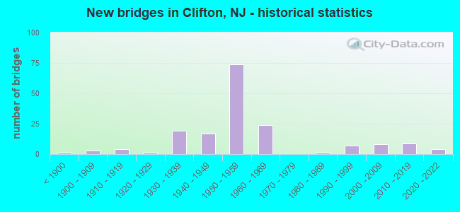
- New bridges - historical statistics
- 1Before 1900
- 31900-1909
- 41910-1919
- 11920-1929
- 191930-1939
- 171940-1949
- 741950-1959
- 241960-1969
- 11980-1989
- 71990-1999
- 82000-2009
- 92010-2019
- 42020-2022
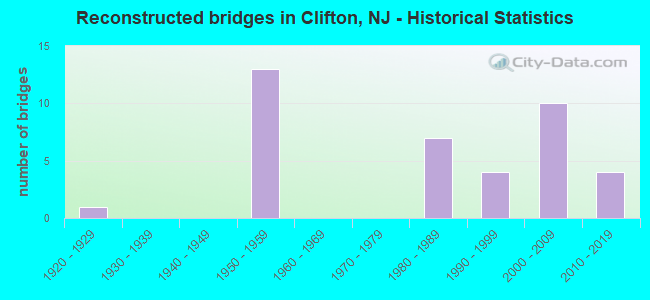
- Reconstructed bridges - Historical Statistics
- 11920-1929
- 01930-1939
- 01940-1949
- 131950-1959
- 01960-1969
- 01970-1979
- 71980-1989
- 41990-1999
- 102000-2009
- 42010-2019
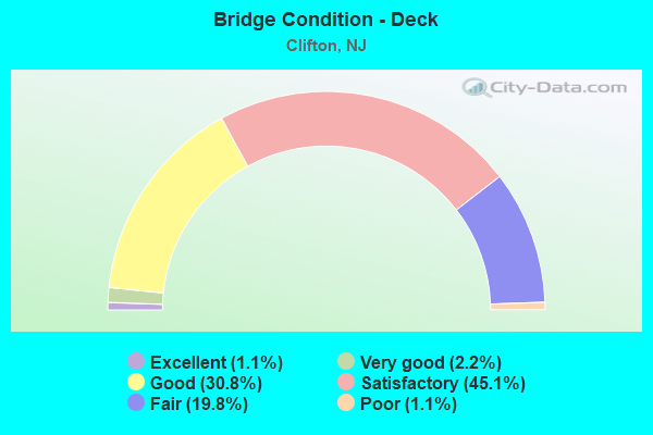
- Bridge Condition - Deck
- 1.1%Excellent
- 2.2%Very good
- 30.8%Good
- 45.1%Satisfactory
- 19.8%Fair
- 1.1%Poor
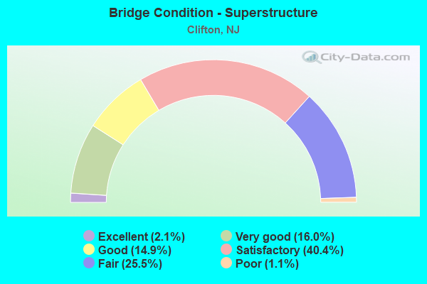
- Bridge Condition - Superstructure
- 2.1%Excellent
- 16.0%Very good
- 14.9%Good
- 40.4%Satisfactory
- 25.5%Fair
- 1.1%Poor
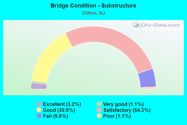
- Bridge Condition - Substructure
- 3.2%Excellent
- 1.1%Very good
- 30.9%Good
- 54.3%Satisfactory
- 9.6%Fair
- 1.1%Poor
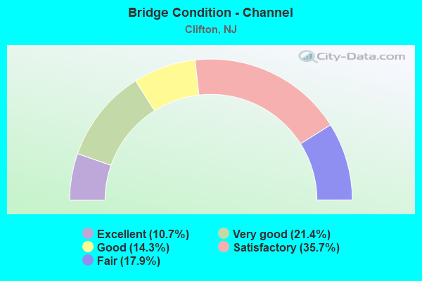
- Bridge Condition - Channel
- 10.7%Excellent
- 21.4%Very good
- 14.3%Good
- 35.7%Satisfactory
- 17.9%Fair
Find on map >> Show street view
Structure Number: 1613154, Location: 1.28 MI NORTH of US 46 (Lat: 40.893611, Lng: -74.168011), Route carried "under" structure: County highway 509, Year Built: 1968, Structure Length: 0. m, Average Daily Traffic: 5,287 (year 2021), Truck Traffic: 4%, Features Intersected: BROAD STREET(CR 509), Facility Carried by Structure: ROUTE NJ 19
Minimum Vertical Clearance: 5.13m (16.83ft), Kilometerpoint: 37.498, Lanes on structure: 6, Lanes under structure: 2, Material/Design: Steel, Design/Construction: Stringer/Multi-beam, Length of Maximum Span: 34.7m (113.8ft)
Find on map >> Show street view
Structure Number: 361541N, Location: AT GSP & RT 3 JUNCTION (Lat: 40.850675, Lng: -74.176375), Route carried "under" structure: Ramp Other road GSP, Year Built: 1953, Structure Length: 0. m, Average Daily Traffic: 9,700 (year 2020), Truck Traffic: 1%, Features Intersected: INT. 153 SB EXIT RAMP B, Facility Carried by Structure: GARDEN ST PKWY NB
Minimum Vertical Clearance: 4.57m (14.99ft), Kilometerpoint: 247.936, Lanes on structure: 3, Lanes under structure: 1, Toll: On toll road, Material/Design: Steel, Design/Construction: Stringer/Multi-beam, Length of Maximum Span: 10.1m (33.1ft)
Find on map >> Show street view
Structure Number: 361541S, Location: AT GSP & RT 3 JUNCTION (Lat: 40.853419, Lng: -74.176328), Route carried "under" structure: Other road GSP, Year Built: 1955, Structure Length: 0. m, Average Daily Traffic: 74,300 (year 2020), Truck Traffic: 1%, Features Intersected: GARDEN STATE PARKWAY SB, Facility Carried by Structure: ROUTE NJ 3
Minimum Vertical Clearance: 4.37m (14.34ft), Kilometerpoint: 248.129, Lanes on structure: 7, Lanes under structure: 4, Toll: On toll road, Material/Design: Steel, Design/Construction: Stringer/Multi-beam, Length of Maximum Span: 20.7m (67.9ft)
Find on map >> Show street view
Structure Number: 361542N, Location: AT GSP & RT 3 JUNCTION (Lat: 40.852131, Lng: -74.175131), Route carried "under" structure: State highway 3, Year Built: 1955, Structure Length: 0. m, Average Daily Traffic: 128,369 (year 2020), Truck Traffic: 4%, Features Intersected: ROUTE NJ 3, Facility Carried by Structure: GARDEN ST PKWY NB
Minimum Vertical Clearance: 4.60m (15.09ft), Kilometerpoint: 2.462, Lanes on structure: 3, Lanes under structure: 6, Material/Design: Steel, Design/Construction: Stringer/Multi-beam, Length of Maximum Span: 24.1m (79.1ft)
Find on map >> Show street view
Structure Number: 361542S, Location: AT GSP & RT 3 JUNCTION (Lat: 40.854400, Lng: -74.175831), Route carried "under" structure: Other road GSP, Year Built: 1953, Structure Length: 0. m, Average Daily Traffic: 96,655 (year 2020), Features Intersected: GSP SB, Facility Carried by Structure: ALLWOOD RD (CR602)
Minimum Vertical Clearance: 4.52m (14.83ft), Kilometerpoint: 248.290, Lanes on structure: 4, Lanes under structure: 3, Toll: On toll road, Material/Design: Steel, Design/Construction: Stringer/Multi-beam, Length of Maximum Span: 20.1m (65.9ft)
Find on map >> Show street view
Structure Number: 361543N, Location: AT GSP & RT 3 JUNCTION (Lat: 40.853478, Lng: -74.174511), Route carried "under" structure: County highway 602, Year Built: 1953, Structure Length: 0. m, Average Daily Traffic: 20,578 (year 2020), Truck Traffic: 1%, Features Intersected: ALLWOOD RD (CR 602), Facility Carried by Structure: GARDEN ST PKWY NB
Minimum Vertical Clearance: 4.57m (14.99ft), Kilometerpoint: 0.354, Lanes on structure: 5, Lanes under structure: 4, Toll: On toll road, Material/Design: Steel, Design/Construction: Stringer/Multi-beam, Length of Maximum Span: 19.8m (65.0ft)
Find on map >> Show street view
Structure Number: 361544A, Location: AT GSP & RT 3 JUNCTION (Lat: 40.859622, Lng: -74.176972), Route carried "under" structure: County highway 509, Year Built: 1955, Structure Length: 0. m, Average Daily Traffic: 17,617 (year 2020), Features Intersected: BROAD ST (CR 509), Facility Carried by Structure: INT 153 RAMPS E&G
Minimum Vertical Clearance: 4.93m (16.17ft), Kilometerpoint: 33.185, Lanes on structure: 2, Lanes under structure: 3, Material/Design: Steel, Design/Construction: Stringer/Multi-beam, Length of Maximum Span: 18.6m (61.0ft)
Find on map >> Show street view
Structure Number: 361544S, Location: AT GSP & RT 3 JUNCTION (Lat: 40.856128, Lng: -74.174736), Route carried "under" structure: Other road GSP, Year Built: 1953, Structure Length: 0. m, Average Daily Traffic: 95,522 (year 2020), Features Intersected: GARDEN STATE PARKWAY SB, Facility Carried by Structure: INT 153 NB RAMP E
Minimum Vertical Clearance: 4.62m (15.16ft), Kilometerpoint: 248.563, Lanes on structure: 1, Lanes under structure: 3, Toll: On toll road, Material/Design: Steel, Design/Construction: Stringer/Multi-beam, Length of Maximum Span: 19.2m (63.0ft)
Find on map >> Show street view
Structure Number: 361554T, Location: 0.5 MI S OF GSP & RT46 JC (Lat: 40.868836, Lng: -74.168186), Route carried "under" structure: Other road GSP, Year Built: 1954, Structure Length: 0. m, Average Daily Traffic: 161,400 (year 2020), Features Intersected: GARDEN ST PARKWAY, Facility Carried by Structure: VAN HOUTEN AVE
Minimum Vertical Clearance: 4.60m (15.09ft), Kilometerpoint: 250.092, Lanes on structure: 3, Lanes under structure: 6, Toll: On toll road, Material/Design: Steel, Design/Construction: Stringer/Multi-beam, Length of Maximum Span: 20.4m (66.9ft)
Find on map >> Show street view
Structure Number: 361557T, Location: 0.25 MI S OF GSP&RT46 JCT (Lat: 40.873669, Lng: -74.166689), Route carried "under" structure: Other road GSP, Year Built: 1953, Structure Length: 0. m, Average Daily Traffic: 133,807 (year 2020), Features Intersected: GARDEN ST PARKWAY, Facility Carried by Structure: COLFAX AVE (CR609)
Minimum Vertical Clearance: 4.95m (16.24ft), Kilometerpoint: 250.623, Lanes on structure: 2, Lanes under structure: 6, Material/Design: Steel, Design/Construction: Stringer/Multi-beam, Length of Maximum Span: 20.1m (65.9ft)
Find on map >> Show street view
Structure Number: 361558T, Location: 2.3 MILES SOUTH OF I80 (Lat: 40.875392, Lng: -74.168339), Route carried "under" structure: Other road GSP, Year Built: 1958, Structure Length: 0. m, Average Daily Traffic: 129,043 (year 2020), Truck Traffic: 1%, Features Intersected: GSP & ROUTE US 46, Facility Carried by Structure: NB ENTRANCE RAMP F
Minimum Vertical Clearance: 13.36m (43.83ft), Kilometerpoint: 250.881, Lanes on structure: 1, Lanes under structure: 7, Toll: On toll road, Material/Design: Steel, Design/Construction: Stringer/Multi-beam, Length of Maximum Span: 33.2m (108.9ft)
Find on map >> Show street view
Structure Number: 361558T, Location: 2.3 MILES SOUTH OF I80 (Lat: 40.875392, Lng: -74.168339), Route carried "under" structure: Ramp US 46, Year Built: 1958, Structure Length: 0. m, Average Daily Traffic: 2,122 (year 2020), Truck Traffic: 1%, Features Intersected: GSP & ROUTE US 46, Facility Carried by Structure: NB ENTRANCE RAMP F
Minimum Vertical Clearance: 4.50m (14.76ft), Kilometerpoint: 98.669, Lanes on structure: 1, Lanes under structure: 1, Material/Design: Steel, Design/Construction: Stringer/Multi-beam, Length of Maximum Span: 33.2m (108.9ft)
Find on map >> Show street view
Structure Number: 361558T, Location: 2.3 MILES SOUTH OF I80 (Lat: 40.875392, Lng: -74.168339), Route carried "under" structure: State highway 19, Year Built: 1958, Structure Length: 0. m, Average Daily Traffic: 64,413 (year 2020), Truck Traffic: 3%, Features Intersected: GSP & ROUTE US 46, Facility Carried by Structure: NB ENTRANCE RAMP F
Minimum Vertical Clearance: 5.51m (18.08ft), Kilometerpoint: 0.177, Lanes on structure: 1, Lanes under structure: 4, Material/Design: Steel, Design/Construction: Stringer/Multi-beam, Length of Maximum Span: 33.2m (108.9ft)
Find on map >> Show street view
Structure Number: 361558T, Location: 2.3 MILES SOUTH OF I80 (Lat: 40.875392, Lng: -74.168339), Route carried "under" structure: Ramp US 46, Year Built: 1958, Structure Length: 0. m, Average Daily Traffic: 2,122 (year 2020), Truck Traffic: 1%, Features Intersected: GSP & ROUTE US 46, Facility Carried by Structure: NB ENTRANCE RAMP F
Minimum Vertical Clearance: 4.72m (15.49ft), Kilometerpoint: 98.669, Lanes on structure: 1, Lanes under structure: 1, Material/Design: Steel, Design/Construction: Stringer/Multi-beam, Length of Maximum Span: 33.2m (108.9ft)
Find on map >> Show street view
Structure Number: 361558T, Location: 2.3 MILES SOUTH OF I80 (Lat: 40.875392, Lng: -74.168339), Route carried "under" structure: US 46, Year Built: 1958, Structure Length: 0. m, Average Daily Traffic: 60,667 (year 2020), Truck Traffic: 4%, Features Intersected: GSP & ROUTE US 46, Facility Carried by Structure: NB ENTRANCE RAMP F
Minimum Vertical Clearance: 4.82m (15.81ft), Kilometerpoint: 98.862, Lanes on structure: 1, Lanes under structure: 5, Material/Design: Steel, Design/Construction: Stringer/Multi-beam, Length of Maximum Span: 33.2m (108.9ft)
Find on map >> Show street view
Structure Number: 361559T, Location: 2.5 MI N OF RT 3-GSP JCT (Lat: 40.876236, Lng: -74.166375), Route carried "under" structure: Other road GSP, Year Built: 1953, Structure Length: 0. m, Average Daily Traffic: 128,533 (year 2020), Truck Traffic: 1%, Features Intersected: GARDEN ST PARKWAY, Facility Carried by Structure: ROUTE US 46
Minimum Vertical Clearance: 5.66m (18.57ft), Kilometerpoint: 250.913, Lanes on structure: 6, Lanes under structure: 7, Material/Design: Steel, Design/Construction: Stringer/Multi-beam, Length of Maximum Span: 24.4m (80.1ft)
Find on map >> Show street view
Structure Number: 361561A, Location: 1.9 MILES SOUTH OF I80 (Lat: 40.878428, Lng: -74.167900), Route carried "under" structure: State highway 19, Year Built: 1958, Structure Length: 0. m, Average Daily Traffic: 24,347 (year 2020), Truck Traffic: 1%, Features Intersected: SB SPUR & ROUTE NJ 19, Facility Carried by Structure: INT. 154 SB RAMP
Minimum Vertical Clearance: 5.08m (16.67ft), Kilometerpoint: 0.547, Lanes on structure: 1, Lanes under structure: 4, Material/Design: Prestressed concrete, Design/Construction: Stringer/Multi-beam, Length of Maximum Span: 29.3m (96.1ft)
Find on map >> Show street view
Structure Number: 361561A, Location: 1.9 MILES SOUTH OF I80 (Lat: 40.878428, Lng: -74.167900), Route carried "under" structure: Ramp Other road GSP, Year Built: 1958, Structure Length: 0. m, Average Daily Traffic: 7,477 (year 2020), Truck Traffic: 1%, Features Intersected: SB SPUR & ROUTE NJ 19, Facility Carried by Structure: INT. 154 SB RAMP
Minimum Vertical Clearance: 4.88m (16.01ft), Kilometerpoint: 251.299, Lanes on structure: 1, Lanes under structure: 1, Toll: On toll road, Material/Design: Prestressed concrete, Design/Construction: Stringer/Multi-beam, Length of Maximum Span: 29.3m (96.1ft)
Find on map >> Show street view
Structure Number: 361561S, Location: AT GSP & RT 19 JUNCTION (Lat: 40.881086, Lng: -74.165981), Route carried "under" structure: Ramp Other road GSP, Year Built: 1953, Structure Length: 0. m, Average Daily Traffic: 71,073 (year 2020), Features Intersected: NB SPUR (ROUTE NJ 19)
Minimum Vertical Clearance: 4.72m (15.49ft), Kilometerpoint: 251.380, Lanes on structure: 4, Lanes under structure: 1, Toll: On toll road, Material/Design: Steel, Design/Construction: Stringer/Multi-beam, Length of Maximum Span: 22.6m (74.1ft)
Find on map >> Show street view
Structure Number: 361563S, Location: 0.3 MI E OF GSP&RT20 JCT (Lat: 40.883150, Lng: -74.164150), Route carried "under" structure: City street , Year Built: 1953, Structure Length: 0. m, Average Daily Traffic: 12,950 (year 2020), Truck Traffic: 3%, Features Intersected: KULLER ROAD, Facility Carried by Structure: GARDEN ST PKWY SB
Minimum Vertical Clearance: 7.62m (25.00ft), Kilometerpoint: 0.579, Lanes on structure: 4, Lanes under structure: 2, Toll: On toll road, Material/Design: Steel, Design/Construction: Stringer/Multi-beam, Length of Maximum Span: 27.1m (88.9ft)
Find on map >> Show street view
Structure Number: 361564N, Location: 0.3 MI E OF GSP&RT20 JCT (Lat: 40.882628, Lng: -74.164056), Route carried "under" structure: City street , Year Built: 1953, Structure Length: 0. m, Average Daily Traffic: 12,950 (year 2020), Truck Traffic: 3%, Features Intersected: KULLER ROAD, Facility Carried by Structure: GARDEN ST PKWY NB
Minimum Vertical Clearance: 7.62m (25.00ft), Kilometerpoint: 0.579, Lanes on structure: 4, Lanes under structure: 2, Material/Design: Steel, Design/Construction: Stringer/Multi-beam, Length of Maximum Span: 19.2m (63.0ft)
Find on map >> Show street view
Structure Number: 361567T, Location: 0.75 MI NE OF GSP&RT46 JC (Lat: 40.884967, Lng: -74.159597), Route carried "under" structure: Other road GSP, Year Built: 1954, Structure Length: 0. m, Average Daily Traffic: 129,975 (year 2020), Truck Traffic: 1%, Features Intersected: GARDEN ST PARKWAY, Facility Carried by Structure: HAZEL STREET
Minimum Vertical Clearance: 4.57m (14.99ft), Kilometerpoint: 252.152, Lanes on structure: 2, Lanes under structure: 6, Toll: On toll road, Material/Design: Steel continuous, Design/Construction: Stringer/Multi-beam, Length of Maximum Span: 19.5m (64.0ft)
Find on map >> Show street view
Structure Number: 361570S, Location: 1 MI NE OF GSP&RT46 JCT (Lat: 40.886806, Lng: -74.151500), Route carried "under" structure: County highway 601, Year Built: 1954, Structure Length: 0. m, Average Daily Traffic: 14,169 (year 2020), Truck Traffic: 4%, Features Intersected: MAIN AVENUE (CR 601), Facility Carried by Structure: GARDEN ST PKWY SB
Minimum Vertical Clearance: 4.52m (14.83ft), Kilometerpoint: 7.998, Lanes on structure: 3, Lanes under structure: 2, Material/Design: Steel, Design/Construction: Stringer/Multi-beam, Length of Maximum Span: 22.3m (73.2ft)
Find on map >> Show street view
Structure Number: 361571N, Location: 1 MI NE OF GSP&RT46 JCT (Lat: 40.886708, Lng: -74.151417), Route carried "under" structure: County highway 601, Year Built: 1954, Structure Length: 0. m, Average Daily Traffic: 14,064 (year 2020), Truck Traffic: 4%, Features Intersected: MAIN AVENUE (CR 601), Facility Carried by Structure: GARDEN ST PKWY NB
Minimum Vertical Clearance: 4.60m (15.09ft), Kilometerpoint: 7.998, Lanes on structure: 3, Lanes under structure: 2, Material/Design: Steel, Design/Construction: Stringer/Multi-beam, Length of Maximum Span: 22.3m (73.2ft)
Find on map >> Show street view
Structure Number: 361571S, Location: 1 MI NE OF GSP&RT46 JCT (Lat: 40.887236, Lng: -74.149583), Route carried "under" structure: City street , Year Built: 1954, Structure Length: 0. m, Average Daily Traffic: 9,115 (year 2020), Truck Traffic: 4%, Features Intersected: GETTY AVE, Facility Carried by Structure: GSP SB
Minimum Vertical Clearance: 4.82m (15.81ft), Kilometerpoint: 0.612, Lanes on structure: 3, Lanes under structure: 2, Material/Design: Steel, Design/Construction: Stringer/Multi-beam, Length of Maximum Span: 23.5m (77.1ft)
Find on map >> Show street view
Structure Number: 361572N, Location: 1 MI NE OF GSP&RT46 JCT (Lat: 40.887111, Lng: -74.149472), Route carried "under" structure: City street , Year Built: 1954, Structure Length: 0. m, Average Daily Traffic: 9,300 (year 2020), Truck Traffic: 3%, Features Intersected: GETTY AVE, Facility Carried by Structure: Parkway N
Minimum Vertical Clearance: 4.72m (15.49ft), Kilometerpoint: 0.612, Lanes on structure: 3, Lanes under structure: 2, Material/Design: Steel, Design/Construction: Stringer/Multi-beam, Length of Maximum Span: 23.5m (77.1ft)
Find on map >> Show street view
Structure Number: 361573S, Location: .75 MI W OF GSP&PASSAIC R (Lat: 40.888208, Lng: -74.145292), Route carried "under" structure: City street , Year Built: 1954, Structure Length: 0. m, Average Daily Traffic: 12,736 (year 2020), Truck Traffic: 1%, Features Intersected: CURIE AVENUE, Facility Carried by Structure: GARDEN ST PKWY SB
Minimum Vertical Clearance: 4.60m (15.09ft), Kilometerpoint: 0.000, Lanes on structure: 3, Lanes under structure: 2, Material/Design: Steel, Design/Construction: Stringer/Multi-beam, Length of Maximum Span: 16.5m (54.1ft)
Find on map >> Show street view
Structure Number: 361574N, Location: .75 MI W OF GSP&PASSAIC R (Lat: 40.887867, Lng: -74.145292), Route carried "under" structure: City street , Year Built: 1954, Structure Length: 0. m, Average Daily Traffic: 12,736 (year 2020), Truck Traffic: 1%, Features Intersected: CURIE AVENUE, Facility Carried by Structure: GARDEN ST PKWY NB
Minimum Vertical Clearance: 4.72m (15.49ft), Kilometerpoint: 0.000, Lanes on structure: 3, Lanes under structure: 2, Material/Design: Steel, Design/Construction: Stringer/Multi-beam, Length of Maximum Span: 16.5m (54.1ft)
Find on map >> Show street view
Structure Number: 361578T, Location: .5 MI W OF GSP&PASSAIC RV (Lat: 40.889022, Lng: -74.139072), Route carried "under" structure: Other road GSP, Year Built: 1954, Structure Length: 0. m, Average Daily Traffic: 121,482 (year 2020), Features Intersected: Garden State Parkway, Facility Carried by Structure: Lakeview Avenue
Minimum Vertical Clearance: 5.64m (18.50ft), Kilometerpoint: 253.954, Lanes on structure: 2, Lanes under structure: 6, Material/Design: Steel, Design/Construction: Stringer/Multi-beam, Length of Maximum Span: 14.3m (46.9ft)
Find on map >> Show street view
Structure Number: 361581A, Location: AT GSP&PASSAIC RIVER JCT (Lat: 40.888019, Lng: -74.131631), Route carried "under" structure: US 46, Year Built: 1954, Structure Length: 0. m, Average Daily Traffic: 103,178 (year 2020), Truck Traffic: 4%, Features Intersected: ROUTE US 46, Facility Carried by Structure: INT. 156 RAMP B
Minimum Vertical Clearance: 5.13m (16.83ft), Kilometerpoint: 102.113, Lanes on structure: 1, Lanes under structure: 6, Material/Design: Steel, Design/Construction: Stringer/Multi-beam, Length of Maximum Span: 20.7m (67.9ft)
Find on map >> Show street view
Structure Number: 361582T, Location: 0.9 MILES SOUTH OF I80 (Lat: 40.532400, Lng: -74.074797), Route carried "under" structure: US 46, Year Built: 1955, Structure Length: 0. m, Average Daily Traffic: 110,969 (year 2021), Truck Traffic: 1%, Features Intersected: PASS.RIV.RT.46,RIVER DR, Facility Carried by Structure: GARDEN STATE PKWY
Minimum Vertical Clearance: 4.57m (14.99ft), Kilometerpoint: 164.671, Lanes on structure: 6, Lanes under structure: 6, Material/Design: Steel, Design/Construction: Girder and Floorbeam System, Length of Maximum Span: 37.8m (124.0ft)
Find on map >> Show street view
Structure Number: 361582T, Location: 0.9 MILES SOUTH OF I80 (Lat: 40.532400, Lng: -74.074797), Route carried "under" structure: County highway 507, Year Built: 1955, Structure Length: 0. m, Average Daily Traffic: 12,367 (year 2021), Truck Traffic: 1%, Features Intersected: PASS.RIV.RT.46,RIVER DR, Facility Carried by Structure: GARDEN STATE PKWY
Minimum Vertical Clearance: 4.39m (14.40ft), Kilometerpoint: 3.106, Lanes on structure: 6, Lanes under structure: 2, Material/Design: Steel, Design/Construction: Girder and Floorbeam System, Length of Maximum Span: 37.8m (124.0ft)