Bridge Statistics for Colchester, New York (NY)
Condition, Traffic, Stress, Structural Evaluation, Project Costs
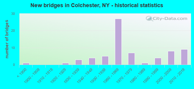
- New bridges - historical statistics
- 1Before 1900
- 11920-1929
- 31930-1939
- 41940-1949
- 51950-1959
- 271960-1969
- 71970-1979
- 11980-1989
- 41990-1999
- 82000-2009
- 92010-2019
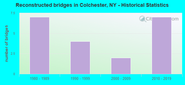
- Reconstructed bridges - Historical Statistics
- 71980-1989
- 41990-1999
- 22000-2009
- 72010-2019
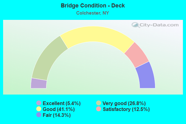
- Bridge Condition - Deck
- 5.4%Excellent
- 26.8%Very good
- 41.1%Good
- 12.5%Satisfactory
- 14.3%Fair
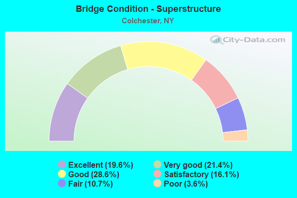
- Bridge Condition - Superstructure
- 19.6%Excellent
- 21.4%Very good
- 28.6%Good
- 16.1%Satisfactory
- 10.7%Fair
- 3.6%Poor
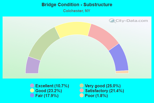
- Bridge Condition - Substructure
- 10.7%Excellent
- 25.0%Very good
- 23.2%Good
- 21.4%Satisfactory
- 17.9%Fair
- 1.8%Poor
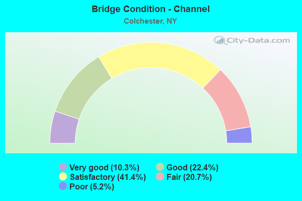
- Bridge Condition - Channel
- 10.3%Very good
- 22.4%Good
- 41.4%Satisfactory
- 20.7%Fair
- 5.2%Poor
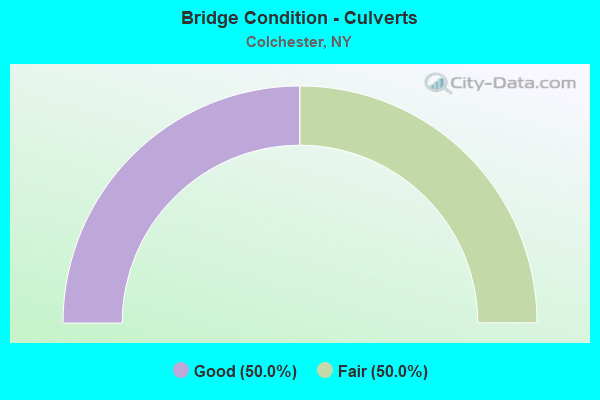
- Bridge Condition - Culverts
- 50.0%Good
- 50.0%Fair
Find on map >> Show street view
Structure Number: 102077, Location: 8.6 MI N JCT SH 30 & SH 1 (Lat: 42.040331, Lng: -75.067650), Route carried "on" structure: State highway 30, Year Built: 1949, Status: Open, Structure Length: 1.31m (4.30ft), Average Daily Traffic: 569 (year 2020), Truck Traffic: 15%, Average Future Daily Traffic: 572 (year 2040), Design Load: HS 15, Features Intersected: TROUT BROOK
Minimum Vertical Clearance: 30+ m (98+ ft), Kilometerpoint: 13.837, Lanes on structure: 2, Base Highway Network: Yes, Owner: State Highway Agency, Approaching Roadway Width: 10.7m (35.1ft), Skew: 3 degrees, Material/Design: Concrete, Design/Construction: Slab, Number Of Spans In Main Unit: 1, Length of Maximum Span: 12.1m (39.7ft), Curb-To-Curb Width: 9.6m (31.5ft), Out-to-Out Width: 10.4m (34.1ft)
Condition: Deck: Fair, Superstructure: Fair, Substructure: Satisfactory, Channel: Satisfactory, Operating Rating: 47.2 metric tons, Method Used To Determine Operating Rating: Load Factor (LF), Inventory Rating: 28.1 metric tons, Method Used To Determine Inventory Rating: Load Factor (LF), Structural Evaluation: Somewhat better than minimum adequacy, Deck Geometry: Equal to present minimum criteria, Waterway Adequacy: Somewhat better than minimum adequacy, Approach Roadway Alignment: Equal to present desirable criteria, Length Of Structure Improvement: 1.31m (4.30ft), Designated Inspection Frequency: Every 24 months, Inspection Date: June 2020, Bridge Improvement Cost: $462,000, Roadway Improvement Cost: $271,000, Total Project Cost: $733,000 ( Estimate for 2021), Wearing Surface/Protective System: Wearing Surface: Bituminous
Find on map >> Show street view
Structure Number: 102078, Location: JCT SH 30 & SH 206 (Lat: 42.080364, Lng: -74.995025), Route carried "on" structure: State highway 30, Year Built: 1949, Year Reconstructed: 1986, Status: Open, Structure Length: 2.01m (6.59ft), Average Daily Traffic: 1,523 (year 2017), Truck Traffic: 9%, Average Future Daily Traffic: 1,532 (year 2040), Design Load: HS 15, Features Intersected: DOWNS CREEK
Minimum Vertical Clearance: 30+ m (98+ ft), Kilometerpoint: 24.071, Lanes on structure: 2, Base Highway Network: Yes, Owner: State Highway Agency, Approaching Roadway Width: 10.4m (34.1ft), Skew: 2 degrees, Material/Design: Steel, Design/Construction: Stringer/Multi-beam, Number Of Spans In Main Unit: 1, Length of Maximum Span: 18.8m (61.7ft), Curb or Sidewalk Widths: Left: 1.6m (5.2ft), Right: 1.5m (4.9ft), Curb-To-Curb Width: 10.4m (34.1ft), Out-to-Out Width: 14.0m (45.9ft)
Condition: Deck: Fair, Superstructure: Satisfactory, Substructure: Fair, Channel: Satisfactory, Operating Rating: 82.6 metric tons, Method Used To Determine Operating Rating: Load Factor (LF), Inventory Rating: 49.0 metric tons, Method Used To Determine Inventory Rating: Load Factor (LF), Structural Evaluation: Somewhat better than minimum adequacy, Deck Geometry: Equal to present minimum criteria, Waterway Adequacy: Meets minimum limits, Approach Roadway Alignment: Equal to present desirable criteria, Length Of Structure Improvement: 2.01m (6.59ft), Designated Inspection Frequency: Every 24 months, Inspection Date: August 2020, Bridge Improvement Cost: $819,000, Roadway Improvement Cost: $480,000, Total Project Cost: $1,299,000 ( Estimate for 2021), Deck Structure Type: Concrete Cast-file-Place, Wearing Surface/Protective System: Wearing Surface: Integral Concrete, Deck Protection: Epoxy Coated Reinforcing
Find on map >> Show street view
Structure Number: 102079, Location: .9 MI E JCT SH 30 & SH206 (Lat: 42.074628, Lng: -74.981939), Route carried "on" structure: State highway 30, Year Built: 2017, Status: Open, Structure Length: 8.11m (26.61ft), Average Daily Traffic: 1,523 (year 2017), Truck Traffic: 9%, Average Future Daily Traffic: 1,532 (year 2040), Design Load: HL 93, Features Intersected: E BR DELAWARE RIVER
Minimum Vertical Clearance: 30+ m (98+ ft), Kilometerpoint: 25.535, Lanes on structure: 2, Base Highway Network: Yes, Owner: Local Agency, Maintenance Responsibility: State Highway Agency, Approaching Roadway Width: 10.4m (34.1ft), Material/Design: Steel continuous, Design/Construction: Stringer/Multi-beam, Number Of Spans In Main Unit: 2, Length of Maximum Span: 40.2m (131.9ft), Curb-To-Curb Width: 10.4m (34.1ft), Out-to-Out Width: 11.4m (37.4ft)
Condition: Deck: Good, Superstructure: Excellent, Substructure: Excellent, Channel: Very good, Operating Rating: 64.4 metric tons, Method Used To Determine Operating Rating: Load Factor (LF), Inventory Rating: 38.1 metric tons, Method Used To Determine Inventory Rating: Load Factor (LF), Structural Evaluation: Superior to present desirable criteria, Deck Geometry: Equal to present minimum criteria, Waterway Adequacy: Equal to present minimum criteria, Approach Roadway Alignment: Equal to present desirable criteria, Length Of Structure Improvement: 8.10m (26.57ft), Designated Inspection Frequency: Every 24 months, Inspection Date: September 2021, Bridge Improvement Cost: $2,056,000, Roadway Improvement Cost: $1,204,000, Total Project Cost: $3,260,000 ( Estimate for 2021), Deck Structure Type: Concrete Cast-file-Place, Wearing Surface/Protective System: Wearing Surface: Integral Concrete, Deck Protection: Epoxy Coated Reinforcing
Find on map >> Show street view
Structure Number: 104044, Location: .5 MI NW JCT SH 206 & SH (Lat: 42.086997, Lng: -75.001897), Route carried "on" structure: State highway 206, Year Built: 1949, Status: Open, Structure Length: 1.25m (4.10ft), Average Daily Traffic: 1,565 (year 2017), Truck Traffic: 10%, Average Future Daily Traffic: 1,574 (year 2040), Features Intersected: WILSON HOLLOW BRK
Minimum Vertical Clearance: 30+ m (98+ ft), Kilometerpoint: 44.585, Lanes on structure: 2, Base Highway Network: Yes, Owner: State Highway Agency, Approaching Roadway Width: 7.9m (25.9ft), Skew: 4 degrees, Material/Design: Steel, Design/Construction: Stringer/Multi-beam, Number Of Spans In Main Unit: 1, Length of Maximum Span: 11.8m (38.7ft), Curb-To-Curb Width: 9.1m (29.9ft), Out-to-Out Width: 9.5m (31.2ft)
Condition: Deck: Fair, Superstructure: Fair, Substructure: Fair, Channel: Satisfactory, Operating Rating: 49.9 metric tons, Method Used To Determine Operating Rating: Load Factor (LF), Inventory Rating: 29.9 metric tons, Method Used To Determine Inventory Rating: Load Factor (LF), Structural Evaluation: Somewhat better than minimum adequacy, Deck Geometry: Somewhat better than minimum adequacy, Waterway Adequacy: Meets minimum limits, Approach Roadway Alignment: Equal to present desirable criteria, Length Of Structure Improvement: 1.24m (4.07ft), Designated Inspection Frequency: Every 24 months, Inspection Date: August 2020, Bridge Improvement Cost: $724,000, Roadway Improvement Cost: $424,000, Total Project Cost: $1,148,000 ( Estimate for 2021), Deck Structure Type: Concrete Cast-file-Place, Wearing Surface/Protective System: Wearing Surface: Bituminous, Membrane: Other
Find on map >> Show street view
Structure Number: 1054941, Location: EXIT 92 OF SH 17 (Lat: 41.970467, Lng: -75.021569), Route carried "on" structure: State highway 17, Year Built: 1968, Year Reconstructed: 1993, Status: Open, Structure Length: 13.11m (43.01ft), Average Daily Traffic: 2,831 (year 2020), Truck Traffic: 30%, Average Future Daily Traffic: 4,418 (year 2040), Design Load: HS 20, Features Intersected: CR 17, BEAVER KILL
Minimum Vertical Clearance: 30+ m (98+ ft), Kilometerpoint: 47.031, Lanes on structure: 2, Lanes under structure: 2, Base Highway Network: Yes, Owner: State Highway Agency, Approaching Roadway Width: 10.1m (33.1ft), Material/Design: Steel, Design/Construction: Stringer/Multi-beam, Number Of Spans In Main Unit: 3, Length of Maximum Span: 54.9m (180.1ft), Curb-To-Curb Width: 10.1m (33.1ft), Out-to-Out Width: 11.0m (36.1ft)
Condition: Deck: Very good, Superstructure: Satisfactory, Substructure: Satisfactory, Channel: Good, Operating Rating: 48.1 metric tons, Method Used To Determine Operating Rating: Load Factor (LF), Inventory Rating: 29.0 metric tons, Method Used To Determine Inventory Rating: Load Factor (LF), Structural Evaluation: Equal to present minimum criteria, Deck Geometry: Somewhat better than minimum adequacy, Underclear: Meets minimum limits, Waterway Adequacy: Somewhat better than minimum adequacy, Approach Roadway Alignment: Equal to present desirable criteria, Length Of Structure Improvement: 13.10m (42.98ft), Designated Inspection Frequency: Every 24 months, Inspection Date: August 2020, Bridge Improvement Cost: $3,003,000, Roadway Improvement Cost: $1,759,000, Total Project Cost: $4,762,000 ( Estimate for 2021), Deck Structure Type: Concrete Cast-file-Place, Wearing Surface/Protective System: Wearing Surface: Integral Concrete, Deck Protection: Epoxy Coated Reinforcing
Find on map >> Show street view
Structure Number: 1054942, Location: EXIT 92 RTE 17 INT (Lat: 41.970242, Lng: -75.022283), Route carried "on" structure: State highway 17, Year Built: 1968, Year Reconstructed: 2013, Status: Open, Structure Length: 13.87m (45.51ft), Average Daily Traffic: 2,831 (year 2020), Truck Traffic: 30%, Average Future Daily Traffic: 4,418 (year 2040), Design Load: HS 20, Features Intersected: CR 17, BEAVER KILL
Minimum Vertical Clearance: 30+ m (98+ ft), Kilometerpoint: 47.031, Lanes on structure: 2, Lanes under structure: 2, Base Highway Network: Yes, Owner: State Highway Agency, Approaching Roadway Width: 10.1m (33.1ft), Material/Design: Steel, Design/Construction: Stringer/Multi-beam, Number Of Spans In Main Unit: 3, Length of Maximum Span: 54.9m (180.1ft), Curb-To-Curb Width: 10.1m (33.1ft), Out-to-Out Width: 11.0m (36.1ft)
Condition: Deck: Very good, Superstructure: Satisfactory, Substructure: Satisfactory, Channel: Satisfactory, Operating Rating: 68.0 metric tons, Method Used To Determine Operating Rating: Load Factor (LF), Inventory Rating: 40.8 metric tons, Method Used To Determine Inventory Rating: Load Factor (LF), Structural Evaluation: Equal to present minimum criteria, Deck Geometry: Somewhat better than minimum adequacy, Underclear: Meets minimum limits, Waterway Adequacy: Somewhat better than minimum adequacy, Approach Roadway Alignment: Equal to present desirable criteria, Length Of Structure Improvement: 13.86m (45.47ft), Designated Inspection Frequency: Every 24 months, Inspection Date: August 2020, Bridge Improvement Cost: $3,169,000, Roadway Improvement Cost: $1,856,000, Total Project Cost: $5,024,000 ( Estimate for 2021), Deck Structure Type: Concrete Cast-file-Place, Wearing Surface/Protective System: Wearing Surface: Integral Concrete, Deck Protection: Epoxy Coated Reinforcing
Find on map >> Show street view
Structure Number: 1054951, Location: 0.5 MI E EXIT 92 - SH 17 (Lat: 41.969964, Lng: -75.014758), Route carried "on" structure: State highway 17, Year Built: 1968, Year Reconstructed: 2018, Status: Open, Structure Length: 15.79m (51.80ft), Average Daily Traffic: 2,522 (year 2020), Truck Traffic: 26%, Average Future Daily Traffic: 3,935 (year 2040), Design Load: HS 20, Features Intersected: CR 17, BEAVER KILL, Chil
Minimum Vertical Clearance: 30+ m (98+ ft), Kilometerpoint: 47.578, Lanes on structure: 2, Lanes under structure: 4, Base Highway Network: Yes, Owner: State Highway Agency, Approaching Roadway Width: 10.1m (33.1ft), Skew: 4 degrees, Material/Design: Steel, Design/Construction: Stringer/Multi-beam, Number Of Spans In Main Unit: 6, Length of Maximum Span: 42.9m (140.7ft), Curb-To-Curb Width: 10.1m (33.1ft), Out-to-Out Width: 11.0m (36.1ft)
Condition: Deck: Good, Superstructure: Good, Substructure: Good, Channel: Satisfactory, Operating Rating: 32.1 metric tons, Method Used To Determine Operating Rating: Load and Resistance Factor Rating (LRFR) rating reported by rating factor(RF) method using HL-93 loadings, Inventory Rating: 24.6 metric tons, Method Used To Determine Inventory Rating: Load and Resistance Factor Rating (LRFR) rating reported by rating factor(RF) method using HL-93 loadings, Structural Evaluation: Equal to present minimum criteria, Deck Geometry: Somewhat better than minimum adequacy, Underclear: Meets minimum limits, Waterway Adequacy: Equal to present minimum criteria, Approach Roadway Alignment: Equal to present desirable criteria, Length Of Structure Improvement: 15.78m (51.77ft), Designated Inspection Frequency: Every 24 months, Inspection Date: September 2021, Bridge Improvement Cost: $3,628,000, Roadway Improvement Cost: $2,125,000, Total Project Cost: $5,753,000 ( Estimate for 2021), Deck Structure Type: Concrete Cast-file-Place, Wearing Surface/Protective System: Wearing Surface: Integral Concrete, Deck Protection: Epoxy Coated Reinforcing
Find on map >> Show street view
Structure Number: 1054952, Location: 0.5 MI E EXIT 92 RTE 17 (Lat: 41.969572, Lng: -75.014431), Route carried "on" structure: State highway 17, Year Built: 1968, Year Reconstructed: 2018, Status: Open, Structure Length: 17.31m (56.79ft), Average Daily Traffic: 2,522 (year 2020), Truck Traffic: 26%, Average Future Daily Traffic: 3,935 (year 2040), Design Load: HS 20, Features Intersected: CR 17, BEAVER KILL, Chil
Minimum Vertical Clearance: 30+ m (98+ ft), Kilometerpoint: 47.578, Lanes on structure: 2, Lanes under structure: 4, Base Highway Network: Yes, Owner: State Highway Agency, Approaching Roadway Width: 10.1m (33.1ft), Skew: 4 degrees, Material/Design: Steel, Design/Construction: Stringer/Multi-beam, Number Of Spans In Main Unit: 6, Length of Maximum Span: 42.9m (140.7ft), Curb-To-Curb Width: 10.1m (33.1ft), Out-to-Out Width: 11.0m (36.1ft)
Condition: Deck: Good, Superstructure: Good, Substructure: Good, Channel: Satisfactory, Operating Rating: 37.2 metric tons, Method Used To Determine Operating Rating: Load Factor (LF), Inventory Rating: 21.8 metric tons, Method Used To Determine Inventory Rating: Load Factor (LF), Structural Evaluation: Somewhat better than minimum adequacy, Deck Geometry: Somewhat better than minimum adequacy, Underclear: Equal to present minimum criteria, Waterway Adequacy: Equal to present minimum criteria, Approach Roadway Alignment: Equal to present desirable criteria, Length Of Structure Improvement: 17.31m (56.79ft), Designated Inspection Frequency: Every 24 months, Inspection Date: September 2021, Bridge Improvement Cost: $3,975,000, Roadway Improvement Cost: $2,328,000, Total Project Cost: $6,303,000 ( Estimate for 2021), Deck Structure Type: Concrete Cast-file-Place, Wearing Surface/Protective System: Wearing Surface: Integral Concrete, Deck Protection: Epoxy Coated Reinforcing
Find on map >> Show street view
Structure Number: 1054961, Location: 3.9 MI NW SULLIVAN CO LN (Lat: 41.959111, Lng: -74.990736), Route carried "on" structure: State highway 17, Year Built: 1968, Year Reconstructed: 1993, Status: Open, Structure Length: 9.81m (32.19ft), Average Daily Traffic: 1,947 (year 2020), Truck Traffic: 26%, Average Future Daily Traffic: 3,037 (year 2040), Design Load: HS 20, Features Intersected: RUSSEL BROOK ROAD, RUSSE
Minimum Vertical Clearance: 30+ m (98+ ft), Kilometerpoint: 49.976, Lanes on structure: 2, Lanes under structure: 2, Base Highway Network: Yes, Owner: State Highway Agency, Approaching Roadway Width: 10.1m (33.1ft), Skew: 2 degrees, Material/Design: Steel, Design/Construction: Stringer/Multi-beam, Number Of Spans In Main Unit: 3, Length of Maximum Span: 39.6m (129.9ft), Curb-To-Curb Width: 10.1m (33.1ft), Out-to-Out Width: 11.0m (36.1ft)
Condition: Deck: Good, Superstructure: Good, Substructure: Very good, Channel: Very good, Operating Rating: 80.7 metric tons, Method Used To Determine Operating Rating: Load Factor (LF), Inventory Rating: 48.1 metric tons, Method Used To Determine Inventory Rating: Load Factor (LF), Structural Evaluation: Better than present minimum criteria, Deck Geometry: Somewhat better than minimum adequacy, Underclear: Somewhat better than minimum adequacy, Waterway Adequacy: Equal to present minimum criteria, Approach Roadway Alignment: Equal to present desirable criteria, Length Of Structure Improvement: 9.81m (32.19ft), Designated Inspection Frequency: Every 24 months, Inspection Date: October 2020, Bridge Improvement Cost: $2,327,000, Roadway Improvement Cost: $1,363,000, Total Project Cost: $3,690,000 ( Estimate for 2021), Deck Structure Type: Concrete Cast-file-Place, Wearing Surface/Protective System: Wearing Surface: Integral Concrete, Deck Protection: Epoxy Coated Reinforcing
Find on map >> Show street view
Structure Number: 1054962, Location: 3.9 MI NW SULLIVAN CL (Lat: 41.958836, Lng: -74.990894), Route carried "on" structure: State highway 17, Year Built: 1968, Year Reconstructed: 1993, Status: Open, Structure Length: 9.48m (31.10ft), Average Daily Traffic: 1,947 (year 2020), Truck Traffic: 26%, Average Future Daily Traffic: 3,037 (year 2040), Design Load: HS 20, Features Intersected: RUSSELL BROOK RD, RUSSEL
Minimum Vertical Clearance: 30+ m (98+ ft), Kilometerpoint: 49.976, Lanes on structure: 2, Lanes under structure: 2, Base Highway Network: Yes, Owner: State Highway Agency, Approaching Roadway Width: 10.1m (33.1ft), Skew: 2 degrees, Material/Design: Steel continuous, Design/Construction: Stringer/Multi-beam, Number Of Spans In Main Unit: 3, Length of Maximum Span: 39.6m (129.9ft), Curb-To-Curb Width: 10.1m (33.1ft), Out-to-Out Width: 11.0m (36.1ft)
Condition: Deck: Good, Superstructure: Very good, Substructure: Very good, Channel: Very good, Operating Rating: 69.9 metric tons, Method Used To Determine Operating Rating: Load Factor (LF), Inventory Rating: 41.7 metric tons, Method Used To Determine Inventory Rating: Load Factor (LF), Structural Evaluation: Equal to present desirable criteria, Deck Geometry: Somewhat better than minimum adequacy, Underclear: Somewhat better than minimum adequacy, Waterway Adequacy: Equal to present minimum criteria, Approach Roadway Alignment: Equal to present desirable criteria, Length Of Structure Improvement: 9.47m (31.07ft), Designated Inspection Frequency: Every 24 months, Inspection Date: October 2020, Bridge Improvement Cost: $2,255,000, Roadway Improvement Cost: $1,320,000, Total Project Cost: $3,575,000 ( Estimate for 2021), Deck Structure Type: Concrete Cast-file-Place, Wearing Surface/Protective System: Wearing Surface: Integral Concrete, Deck Protection: Epoxy Coated Reinforcing
Find on map >> Show street view
Structure Number: 1054971, Location: 2.7 MI NW SULLIVAN CL (Lat: 41.952083, Lng: -74.971553), Route carried "on" structure: State highway 17, Year Built: 1968, Year Reconstructed: 2018, Status: Open, Structure Length: 16.73m (54.89ft), Average Daily Traffic: 1,947 (year 2020), Truck Traffic: 26%, Average Future Daily Traffic: 3,037 (year 2040), Design Load: HS 20+Mod, Features Intersected: COOK FALLS ROAD, BEAVER
Minimum Vertical Clearance: 30+ m (98+ ft), Kilometerpoint: 51.858, Lanes on structure: 2, Lanes under structure: 2, Base Highway Network: Yes, Owner: State Highway Agency, Approaching Roadway Width: 11.6m (38.1ft), Skew: 4 degrees, Material/Design: Steel, Design/Construction: Stringer/Multi-beam, Number Of Spans In Main Unit: 5, Length of Maximum Span: 40.2m (131.9ft), Curb-To-Curb Width: 9.0m (29.5ft), Out-to-Out Width: 10.0m (32.8ft)
Condition: Deck: Good, Superstructure: Good, Substructure: Good, Channel: Good, Operating Rating: 44.7 metric tons, Method Used To Determine Operating Rating: Load and Resistance Factor Rating (LRFR) rating reported by rating factor(RF) method using HL-93 loadings, Inventory Rating: 34.3 metric tons, Method Used To Determine Inventory Rating: Load and Resistance Factor Rating (LRFR) rating reported by rating factor(RF) method using HL-93 loadings, Structural Evaluation: Better than present minimum criteria, Deck Geometry: High priority of corrective action, Underclear: Meets minimum limits, Waterway Adequacy: Equal to present minimum criteria, Approach Roadway Alignment: Equal to present desirable criteria, Length Of Structure Improvement: 16.73m (54.89ft), Designated Inspection Frequency: Every 24 months, Inspection Date: October 2021, Bridge Improvement Cost: $3,558,000, Roadway Improvement Cost: $2,084,000, Total Project Cost: $5,642,000 ( Estimate for 2021), Deck Structure Type: Concrete Cast-file-Place, Wearing Surface/Protective System: Wearing Surface: Epoxy Overlay
Find on map >> Show street view
Structure Number: 1054972, Location: 2.7 MI NW SULLIVAN CL (Lat: 41.951808, Lng: -74.971053), Route carried "on" structure: State highway 17, Year Built: 1968, Year Reconstructed: 2019, Status: Open, Structure Length: 18.29m (60.01ft), Average Daily Traffic: 1,947 (year 2020), Truck Traffic: 26%, Average Future Daily Traffic: 3,037 (year 2040), Design Load: HS 20+Mod, Features Intersected: COOK FALLS ROAD, BEAVER
Minimum Vertical Clearance: 30+ m (98+ ft), Kilometerpoint: 51.858, Lanes on structure: 2, Lanes under structure: 2, Base Highway Network: Yes, Owner: State Highway Agency, Approaching Roadway Width: 11.6m (38.1ft), Skew: 5 degrees, Material/Design: Steel, Design/Construction: Stringer/Multi-beam, Number Of Spans In Main Unit: 5, Length of Maximum Span: 42.9m (140.7ft), Curb-To-Curb Width: 9.0m (29.5ft), Out-to-Out Width: 10.0m (32.8ft)
Condition: Deck: Good, Superstructure: Good, Substructure: Good, Channel: Good, Operating Rating: 33.7 metric tons, Method Used To Determine Operating Rating: Load and Resistance Factor Rating (LRFR) rating reported by rating factor(RF) method using HL-93 loadings, Inventory Rating: 25.9 metric tons, Method Used To Determine Inventory Rating: Load and Resistance Factor Rating (LRFR) rating reported by rating factor(RF) method using HL-93 loadings, Structural Evaluation: Equal to present minimum criteria, Deck Geometry: High priority of corrective action, Underclear: Meets minimum limits, Waterway Adequacy: Equal to present minimum criteria, Approach Roadway Alignment: Equal to present desirable criteria, Length Of Structure Improvement: 18.28m (59.97ft), Designated Inspection Frequency: Every 24 months, Inspection Date: October 2021, Bridge Improvement Cost: $3,876,000, Roadway Improvement Cost: $2,270,000, Total Project Cost: $6,145,000 ( Estimate for 2021), Deck Structure Type: Concrete Cast-file-Place, Wearing Surface/Protective System: Wearing Surface: Epoxy Overlay
Find on map >> Show street view
Structure Number: 1054981, Location: 2.4 MI NW SULLIVAN CO LN (Lat: 41.950494, Lng: -74.965869), Route carried "on" structure: State highway 17, Year Built: 1968, Year Reconstructed: 1993, Status: Open, Structure Length: 14.17m (46.49ft), Average Daily Traffic: 1,947 (year 2020), Truck Traffic: 26%, Average Future Daily Traffic: 3,037 (year 2040), Design Load: HS 20, Features Intersected: CR 17, BEAVER KILL
Minimum Vertical Clearance: 30+ m (98+ ft), Kilometerpoint: 52.389, Lanes on structure: 2, Lanes under structure: 2, Base Highway Network: Yes, Owner: State Highway Agency, Approaching Roadway Width: 10.1m (33.1ft), Material/Design: Steel, Design/Construction: Stringer/Multi-beam, Number Of Spans In Main Unit: 3, Length of Maximum Span: 61.0m (200.1ft), Curb-To-Curb Width: 10.1m (33.1ft), Out-to-Out Width: 11.0m (36.1ft)
Condition: Deck: Good, Superstructure: Good, Substructure: Good, Channel: Good, Operating Rating: 78.0 metric tons, Method Used To Determine Operating Rating: Load Factor (LF), Inventory Rating: 46.3 metric tons, Method Used To Determine Inventory Rating: Load Factor (LF), Structural Evaluation: Better than present minimum criteria, Deck Geometry: Somewhat better than minimum adequacy, Underclear: Somewhat better than minimum adequacy, Waterway Adequacy: Equal to present minimum criteria, Approach Roadway Alignment: Equal to present desirable criteria, Length Of Structure Improvement: 14.17m (46.49ft), Designated Inspection Frequency: Every 24 months, Inspection Date: October 2020, Bridge Improvement Cost: $3,317,000, Roadway Improvement Cost: $1,942,000, Total Project Cost: $5,259,000 ( Estimate for 2021), Deck Structure Type: Concrete Cast-file-Place, Wearing Surface/Protective System: Wearing Surface: Integral Concrete, Deck Protection: Epoxy Coated Reinforcing
Find on map >> Show street view
Structure Number: 1054982, Location: 2.4 MI NW SULLIVAN CL (Lat: 41.950144, Lng: -74.965481), Route carried "on" structure: State highway 17, Year Built: 1968, Year Reconstructed: 1993, Status: Open, Structure Length: 14.17m (46.49ft), Average Daily Traffic: 1,947 (year 2020), Truck Traffic: 26%, Average Future Daily Traffic: 3,037 (year 2040), Design Load: HS 20, Features Intersected: CR 17, BEAVER KILL
Minimum Vertical Clearance: 30+ m (98+ ft), Kilometerpoint: 52.389, Lanes on structure: 2, Lanes under structure: 2, Base Highway Network: Yes, Owner: State Highway Agency, Approaching Roadway Width: 10.1m (33.1ft), Material/Design: Steel, Design/Construction: Stringer/Multi-beam, Number Of Spans In Main Unit: 3, Length of Maximum Span: 61.0m (200.1ft), Curb-To-Curb Width: 10.1m (33.1ft), Out-to-Out Width: 11.0m (36.1ft)
Condition: Deck: Satisfactory, Superstructure: Good, Substructure: Good, Channel: Good, Operating Rating: 53.5 metric tons, Method Used To Determine Operating Rating: Load Factor (LF), Inventory Rating: 31.8 metric tons, Method Used To Determine Inventory Rating: Load Factor (LF), Structural Evaluation: Better than present minimum criteria, Deck Geometry: Somewhat better than minimum adequacy, Underclear: Meets minimum limits, Waterway Adequacy: Equal to present minimum criteria, Approach Roadway Alignment: Equal to present desirable criteria, Length Of Structure Improvement: 14.17m (46.49ft), Designated Inspection Frequency: Every 24 months, Inspection Date: October 2020, Bridge Improvement Cost: $3,317,000, Roadway Improvement Cost: $1,942,000, Total Project Cost: $5,259,000 ( Estimate for 2021), Deck Structure Type: Concrete Cast-file-Place, Wearing Surface/Protective System: Wearing Surface: Integral Concrete, Deck Protection: Epoxy Coated Reinforcing
Find on map >> Show street view
Structure Number: 1054991, Location: 0.6MI N SULLIVAN CL (Lat: 41.956056, Lng: -74.936194), Route carried "on" structure: State highway 17, Year Built: 1968, Year Reconstructed: 2018, Status: Open, Structure Length: 11.06m (36.29ft), Average Daily Traffic: 1,947 (year 2020), Truck Traffic: 26%, Average Future Daily Traffic: 3,037 (year 2040), Design Load: HS 20+Mod, Features Intersected: CR 17, BEAVER KILL
Minimum Vertical Clearance: 30+ m (98+ ft), Kilometerpoint: 55.205, Lanes on structure: 2, Lanes under structure: 2, Base Highway Network: Yes, Owner: State Highway Agency, Approaching Roadway Width: 12.2m (40.0ft), Skew: 3 degrees, Material/Design: Steel, Design/Construction: Stringer/Multi-beam, Number Of Spans In Main Unit: 3, Length of Maximum Span: 42.0m (137.8ft), Curb-To-Curb Width: 9.0m (29.5ft), Out-to-Out Width: 10.0m (32.8ft)
Condition: Deck: Satisfactory, Superstructure: Satisfactory, Substructure: Fair, Channel: Satisfactory, Operating Rating: 48.0 metric tons, Method Used To Determine Operating Rating: Load and Resistance Factor Rating (LRFR) rating reported by rating factor(RF) method using HL-93 loadings, Inventory Rating: 36.9 metric tons, Method Used To Determine Inventory Rating: Load and Resistance Factor Rating (LRFR) rating reported by rating factor(RF) method using HL-93 loadings, Structural Evaluation: Somewhat better than minimum adequacy, Deck Geometry: High priority of corrective action, Underclear: Meets minimum limits, Waterway Adequacy: Meets minimum limits, Approach Roadway Alignment: Equal to present desirable criteria, Length Of Structure Improvement: 11.06m (36.29ft), Designated Inspection Frequency: Every 24 months, Inspection Date: July 2021, Bridge Improvement Cost: $2,438,000, Roadway Improvement Cost: $1,428,000, Total Project Cost: $3,866,000 ( Estimate for 2021), Deck Structure Type: Concrete Cast-file-Place, Wearing Surface/Protective System: Wearing Surface: Epoxy Overlay
Find on map >> Show street view
Structure Number: 1054992, Location: 0.6MI N SULLIVAN CL (Lat: 41.955961, Lng: -74.936925), Route carried "on" structure: State highway 17, Year Built: 1968, Status: Open, Structure Length: 13.17m (43.21ft), Average Daily Traffic: 1,947 (year 2020), Truck Traffic: 26%, Average Future Daily Traffic: 3,037 (year 2040), Design Load: HS 20+Mod, Features Intersected: CR 17, BEAVER KILL
Minimum Vertical Clearance: 30+ m (98+ ft), Kilometerpoint: 55.205, Lanes on structure: 2, Lanes under structure: 2, Base Highway Network: Yes, Owner: State Highway Agency, Approaching Roadway Width: 11.9m (39.0ft), Skew: 3 degrees, Material/Design: Steel, Design/Construction: Stringer/Multi-beam, Number Of Spans In Main Unit: 4, Length of Maximum Span: 42.9m (140.7ft), Curb-To-Curb Width: 9.0m (29.5ft), Out-to-Out Width: 10.0m (32.8ft)
Condition: Deck: Good, Superstructure: Good, Substructure: Satisfactory, Channel: Good, Operating Rating: 48.6 metric tons, Method Used To Determine Operating Rating: Load and Resistance Factor Rating (LRFR) rating reported by rating factor(RF) method using HL-93 loadings, Inventory Rating: 37.6 metric tons, Method Used To Determine Inventory Rating: Load and Resistance Factor Rating (LRFR) rating reported by rating factor(RF) method using HL-93 loadings, Structural Evaluation: Equal to present minimum criteria, Deck Geometry: High priority of corrective action, Underclear: Meets minimum limits, Waterway Adequacy: Somewhat better than minimum adequacy, Approach Roadway Alignment: Equal to present desirable criteria, Length Of Structure Improvement: 13.16m (43.18ft), Designated Inspection Frequency: Every 24 months, Inspection Date: July 2021, Bridge Improvement Cost: $2,817,000, Roadway Improvement Cost: $1,650,000, Total Project Cost: $4,467,000 ( Estimate for 2021), Deck Structure Type: Concrete Cast-file-Place, Wearing Surface/Protective System: Wearing Surface: Monolithic Concrete
Find on map >> Show street view
Structure Number: 109455, Location: 2.6 MI NW JCT SH 206 & SH (Lat: 42.107644, Lng: -75.027811), Route carried "on" structure: State highway 206, Year Built: 1937, Status: Open, Structure Length: 0.82m (2.69ft), Average Daily Traffic: 1,565 (year 2017), Truck Traffic: 10%, Average Future Daily Traffic: 1,574 (year 2040), Features Intersected: WILSON HOLLOW BRK
Minimum Vertical Clearance: 30+ m (98+ ft), Kilometerpoint: 41.271, Lanes on structure: 2, Base Highway Network: Yes, Owner: State Highway Agency, Approaching Roadway Width: 8.5m (27.9ft), Skew: 4 degrees, Material/Design: Concrete, Design/Construction: Culvert, Number Of Spans In Main Unit: 1, Length of Maximum Span: 7.9m (25.9ft)
Condition: Channel: Fair, Culverts: Fair, Inventory Rating: 71.7 metric tons, Method Used To Determine Inventory Rating: Load Factor (LF), Structural Evaluation: Somewhat better than minimum adequacy, Waterway Adequacy: Meets minimum limits, Approach Roadway Alignment: Equal to present desirable criteria, Length Of Structure Improvement: 0.82m (2.69ft), Designated Inspection Frequency: Every 24 months, Inspection Date: August 2020, Bridge Improvement Cost: $269,000, Roadway Improvement Cost: $157,000, Total Project Cost: $426,000 ( Estimate for 2021)
Find on map >> Show street view
Structure Number: 22266, Location: 5.5 MILES NE OF ROSCOE (Lat: 41.985278, Lng: -74.850453), Route carried "on" structure: Other road , Year Built: 1978, Year Reconstructed: 2019, Status: Open, Structure Length: 1.52m (4.99ft), Average Daily Traffic: 55 (year 2018), Average Future Daily Traffic: 77 (year 2038), Design Load: HS 20, Features Intersected: BERRY BROOK, Facility Carried by Structure: HOLIDAY&BRY BK RD
Minimum Vertical Clearance: 30+ m (98+ ft), Kilometerpoint: 0.097, Lanes on structure: 2, Owner: County Highway Agency, Approaching Roadway Width: 5.5m (18.0ft), Skew: 6 degrees, Material/Design: Steel, Design/Construction: Stringer/Multi-beam, Number Of Spans In Main Unit: 1, Length of Maximum Span: 12.4m (40.7ft), Curb-To-Curb Width: 6.7m (22.0ft), Out-to-Out Width: 7.0m (23.0ft)
Condition: Deck: Excellent, Superstructure: Excellent, Substructure: Satisfactory, Channel: Fair, Operating Rating: 55.3 metric tons, Method Used To Determine Operating Rating: Allowable Stress (AS), Inventory Rating: 40.8 metric tons, Method Used To Determine Inventory Rating: Allowable Stress (AS), Structural Evaluation: Equal to present minimum criteria, Deck Geometry: Somewhat better than minimum adequacy, Waterway Adequacy: Meets minimum limits, Approach Roadway Alignment: Meets minimum limits, Length Of Structure Improvement: 1.52m (4.99ft), Designated Inspection Frequency: Every 24 months, Inspection Date: October 2021, Bridge Improvement Cost: $581,000, Roadway Improvement Cost: $340,000, Total Project Cost: $921,000 ( Estimate for 2021), Deck Structure Type: Wood or Timber, Wearing Surface/Protective System: Wearing Surface: Bituminous
Find on map >> Show street view
Structure Number: 222661, Location: 5.5 MILES NE OF ROSCOE (Lat: 41.985917, Lng: -74.849603), Route carried "on" structure: Other road , Year Built: 1978, Year Reconstructed: 2019, Status: Open, Structure Length: 1.43m (4.69ft), Average Daily Traffic: 55 (year 2018), Average Future Daily Traffic: 77 (year 2038), Design Load: HS 20, Features Intersected: BERRY BROOK, Facility Carried by Structure: HOLIDAY & BERRY BR
Minimum Vertical Clearance: 30+ m (98+ ft), Kilometerpoint: 0.209, Lanes on structure: 2, Owner: County Highway Agency, Approaching Roadway Width: 5.5m (18.0ft), Skew: 5 degrees, Material/Design: Steel, Design/Construction: Stringer/Multi-beam, Number Of Spans In Main Unit: 1, Length of Maximum Span: 13.1m (43.0ft), Curb-To-Curb Width: 6.4m (21.0ft), Out-to-Out Width: 6.5m (21.3ft)
Condition: Deck: Excellent, Superstructure: Excellent, Substructure: Good, Channel: Satisfactory, Operating Rating: 55.3 metric tons, Method Used To Determine Operating Rating: Allowable Stress (AS), Inventory Rating: 40.8 metric tons, Method Used To Determine Inventory Rating: Allowable Stress (AS), Structural Evaluation: Better than present minimum criteria, Deck Geometry: Somewhat better than minimum adequacy, Waterway Adequacy: Meets minimum limits, Approach Roadway Alignment: Better than present minimum criteria, Length Of Structure Improvement: 1.49m (4.89ft), Designated Inspection Frequency: Every 24 months, Inspection Date: November 2021, Bridge Improvement Cost: $470,000, Roadway Improvement Cost: $276,000, Total Project Cost: $746,000 ( Estimate for 2021), Deck Structure Type: Wood or Timber, Wearing Surface/Protective System: Wearing Surface: Bituminous
Find on map >> Show street view
Structure Number: 222664, Location: 3 MI SW OF DOWNSVILLE (Lat: 42.044733, Lng: -75.021364), Route carried "on" structure: Other road , Year Built: 1983, Status: Open, Structure Length: 1.22m (4.00ft), Average Daily Traffic: 243 (year 2016), Truck Traffic: 5%, Average Future Daily Traffic: 340 (year 2036), Design Load: HS 20, Features Intersected: CAMPBELL BROOK, Facility Carried by Structure: RIVER ROAD
Minimum Vertical Clearance: 30+ m (98+ ft), Kilometerpoint: 5.969, Lanes on structure: 2, Owner: County Highway Agency, Approaching Roadway Width: 5.5m (18.0ft), Skew: 1 degrees, Material/Design: Steel, Design/Construction: Stringer/Multi-beam, Number Of Spans In Main Unit: 1, Length of Maximum Span: 10.9m (35.8ft), Curb-To-Curb Width: 7.5m (24.6ft), Out-to-Out Width: 8.0m (26.2ft)
Condition: Deck: Good, Superstructure: Good, Substructure: Good, Channel: Fair, Operating Rating: 70.8 metric tons, Method Used To Determine Operating Rating: Load Factor (LF), Inventory Rating: 41.7 metric tons, Method Used To Determine Inventory Rating: Load Factor (LF), Structural Evaluation: Better than present minimum criteria, Deck Geometry: Somewhat better than minimum adequacy, Waterway Adequacy: Meets minimum limits, Approach Roadway Alignment: Equal to present desirable criteria, Length Of Structure Improvement: 1.21m (3.97ft), Designated Inspection Frequency: Every 24 months, Inspection Date: October 2020, Bridge Improvement Cost: $406,000, Roadway Improvement Cost: $238,000, Total Project Cost: $644,000 ( Estimate for 2021), Deck Structure Type: Concrete Cast-file-Place, Wearing Surface/Protective System: Wearing Surface: Bituminous
Find on map >> Show street view
Structure Number: 222665, Location: 8 MI NE DOWNSVILLE (Lat: 42.129083, Lng: -74.898333), Route carried "on" structure: Other road , Year Built: 1930, Year Reconstructed: 1999, Status: Posted for load, Structure Length: 1.01m (3.31ft), Average Daily Traffic: 7 (year 2017), Truck Traffic: 5%, Average Future Daily Traffic: 10 (year 2037), Features Intersected: COLES CLOVE BROOK, Facility Carried by Structure: EDWARDS ROAD
Minimum Vertical Clearance: 30+ m (98+ ft), Kilometerpoint: 0.257, Lanes on structure: 1, Owner: County Highway Agency, Approaching Roadway Width: 4.0m (13.1ft), Material/Design: Wood or Timber, Design/Construction: Slab, Number Of Spans In Main Unit: 1, Length of Maximum Span: 8.2m (26.9ft), Curb-To-Curb Width: 4.0m (13.1ft), Out-to-Out Width: 4.3m (14.1ft)
Condition: Deck: Fair, Superstructure: Fair, Substructure: Fair, Channel: Satisfactory, Operating Rating: 47.2 metric tons, Method Used To Determine Operating Rating: Allowable Stress (AS), Inventory Rating: 33.6 metric tons, Method Used To Determine Inventory Rating: Allowable Stress (AS), Structural Evaluation: Somewhat better than minimum adequacy, Deck Geometry: Somewhat better than minimum adequacy, Waterway Adequacy: Somewhat better than minimum adequacy, Approach Roadway Alignment: Better than present minimum criteria, Bridge Posting: Required (Relationship of Operating Rating to Maximum Legal Load: > 39.9% below), Length Of Structure Improvement: 1.00m (3.28ft), Designated Inspection Frequency: Every 12 months, Inspection Date: June 2021, Bridge Improvement Cost: $153,000, Roadway Improvement Cost: $89,000, Total Project Cost: $242,000 ( Estimate for 2021), Wearing Surface/Protective System: Wearing Surface: Wood or Timber
Find on map >> Show street view
Structure Number: 226611, Location: 2.1 MI NE OF DOWNSVILLE (Lat: 42.102333, Lng: -74.970669), Route carried "on" structure: Other road , Year Built: 1974, Status: Open, Structure Length: 0.91m (2.99ft), Average Daily Traffic: 25 (year 2017), Truck Traffic: 5%, Average Future Daily Traffic: 35 (year 2037), Design Load: HS 20, Features Intersected: DOWNS BROOK, Facility Carried by Structure: DOE BROOK ROAD
Minimum Vertical Clearance: 30+ m (98+ ft), Kilometerpoint: 0.032, Lanes on structure: 2, Owner: County Highway Agency, Approaching Roadway Width: 4.9m (16.1ft), Material/Design: Steel, Design/Construction: Stringer/Multi-beam, Number Of Spans In Main Unit: 1, Length of Maximum Span: 8.5m (27.9ft), Curb-To-Curb Width: 5.2m (17.1ft), Out-to-Out Width: 5.5m (18.0ft)
Condition: Deck: Satisfactory, Superstructure: Good, Substructure: Satisfactory, Channel: Good, Operating Rating: 66.2 metric tons, Method Used To Determine Operating Rating: Allowable Stress (AS), Inventory Rating: 49.0 metric tons, Method Used To Determine Inventory Rating: Allowable Stress (AS), Structural Evaluation: Equal to present minimum criteria, Deck Geometry: High priority of corrective action, Waterway Adequacy: Meets minimum limits, Approach Roadway Alignment: Somewhat better than minimum adequacy, Length Of Structure Improvement: 0.91m (2.99ft), Designated Inspection Frequency: Every 24 months, Inspection Date: May 2021, Bridge Improvement Cost: $311,000, Roadway Improvement Cost: $182,000, Total Project Cost: $493,000 ( Estimate for 2021), Deck Structure Type: Wood or Timber, Wearing Surface/Protective System: Wearing Surface: Bituminous
Find on map >> Show street view
Structure Number: 227075, Location: Colchester (Lat: 42.059156, Lng: -74.872217), Route carried "on" structure: County highway , Year Built: 2014, Status: Open, Structure Length: 1.13m (3.71ft), Average Daily Traffic: 50 (year 2019), Truck Traffic: 4%, Average Future Daily Traffic: 70 (year 2039), Design Load: HS 20, Features Intersected: Holiday Brook, Facility Carried by Structure: Holiday Brook Road
Minimum Vertical Clearance: 30+ m (98+ ft), Kilometerpoint: 0.129, Lanes on structure: 2, Owner: County Highway Agency, Approaching Roadway Width: 4.3m (14.1ft), Skew: 2 degrees, Material/Design: Concrete, Design/Construction: Slab, Number Of Spans In Main Unit: 1, Length of Maximum Span: 10.1m (33.1ft), Curb-To-Curb Width: 7.4m (24.3ft), Out-to-Out Width: 8.2m (26.9ft)
Condition: Deck: Very good, Superstructure: Very good, Substructure: Excellent, Channel: Satisfactory, Operating Rating: 61.2 metric tons, Method Used To Determine Operating Rating: Load and Resistance Factor Rating (LRFR) rating reported by rating factor(RF) method using HL-93 loadings, Inventory Rating: 47.3 metric tons, Method Used To Determine Inventory Rating: Load and Resistance Factor Rating (LRFR) rating reported by rating factor(RF) method using HL-93 loadings, Structural Evaluation: Equal to present desirable criteria, Deck Geometry: Equal to present minimum criteria, Waterway Adequacy: Equal to present minimum criteria, Approach Roadway Alignment: Meets minimum limits, Length Of Structure Improvement: 1.12m (3.67ft), Designated Inspection Frequency: Every 24 months, Inspection Date: November 2020, Bridge Improvement Cost: $289,000, Roadway Improvement Cost: $169,000, Total Project Cost: $458,000 ( Estimate for 2021), Wearing Surface/Protective System: Wearing Surface: Bituminous
Find on map >> Show street view
Structure Number: 335187, Location: 2.5 MI N OF ROCKLAND (Lat: 41.965092, Lng: -74.906906), Route carried "on" structure: County highway 206, Year Built: 1955, Year Reconstructed: 1990, Status: Open, Structure Length: 5.18m (16.99ft), Average Daily Traffic: 2,371 (year 2020), Truck Traffic: 3%, Average Future Daily Traffic: 2,473 (year 2040), Design Load: HS 20, Features Intersected: BEAVER KILL
Minimum Vertical Clearance: 30+ m (98+ ft), Kilometerpoint: 64.794, Lanes on structure: 2, Base Highway Network: Yes, Owner: County Highway Agency, Approaching Roadway Width: 9.8m (32.2ft), Skew: 3 degrees, Material/Design: Steel, Design/Construction: Stringer/Multi-beam, Number Of Spans In Main Unit: 2, Length of Maximum Span: 25.2m (82.7ft), Curb-To-Curb Width: 9.8m (32.2ft), Out-to-Out Width: 11.4m (37.4ft)
Condition: Deck: Good, Superstructure: Very good, Substructure: Satisfactory, Channel: Satisfactory, Operating Rating: 77.1 metric tons, Method Used To Determine Operating Rating: Load Factor (LF), Inventory Rating: 46.3 metric tons, Method Used To Determine Inventory Rating: Load Factor (LF), Structural Evaluation: Equal to present minimum criteria, Deck Geometry: Meets minimum limits, Waterway Adequacy: Meets minimum limits, Approach Roadway Alignment: Equal to present desirable criteria, Length Of Structure Improvement: 5.18m (16.99ft), Designated Inspection Frequency: Every 24 months, Underwater Inspection Frequency: Every 60 months, Inspection Date: November 2020, Underwater Inspection Date: October 2013, Bridge Improvement Cost: $1,617,000, Roadway Improvement Cost: $947,000, Total Project Cost: $2,564,000 ( Estimate for 2021), Deck Structure Type: Concrete Cast-file-Place, Wearing Surface/Protective System: Wearing Surface: Bituminous, Deck Protection: Epoxy Coated Reinforcing
Find on map >> Show street view
Structure Number: 335188, Location: 4.5 MI NORTH OF ROCKLAND (Lat: 41.967758, Lng: -74.898739), Route carried "on" structure: Other road , Year Built: 1995, Status: Open, Structure Length: 0.98m (3.22ft), Average Daily Traffic: 201 (year 2017), Truck Traffic: 5%, Average Future Daily Traffic: 281 (year 2037), Design Load: HS 20, Features Intersected: SPRING BROOK, Facility Carried by Structure: BEAVER KILL ROAD
Minimum Vertical Clearance: 30+ m (98+ ft), Kilometerpoint: 0.080, Lanes on structure: 2, Owner: County Highway Agency, Approaching Roadway Width: 8.8m (28.9ft), Skew: 1 degrees, Material/Design: Steel, Design/Construction: Stringer/Multi-beam, Number Of Spans In Main Unit: 1, Length of Maximum Span: 8.5m (27.9ft), Curb-To-Curb Width: 8.6m (28.2ft), Out-to-Out Width: 8.8m (28.9ft)
Condition: Deck: Satisfactory, Superstructure: Poor, Substructure: Good, Channel: Satisfactory, Operating Rating: 55.3 metric tons, Method Used To Determine Operating Rating: Allowable Stress (AS), Inventory Rating: 40.8 metric tons, Method Used To Determine Inventory Rating: Allowable Stress (AS), Structural Evaluation: Meets minimum limits, Deck Geometry: Equal to present minimum criteria, Waterway Adequacy: Meets minimum limits, Approach Roadway Alignment: Equal to present desirable criteria, Length Of Structure Improvement: 0.97m (3.18ft), Designated Inspection Frequency: Every 12 months, Inspection Date: August 2020, Bridge Improvement Cost: $237,000, Roadway Improvement Cost: $139,000, Total Project Cost: $376,000 ( Estimate for 2021), Deck Structure Type: Corrugated Steel, Wearing Surface/Protective System: Wearing Surface: Bituminous, Membrane: Other
Find on map >> Show street view
Structure Number: 335189, Location: 5.3 MI NORTH OF ROCKLAND (Lat: 41.978758, Lng: -74.893497), Route carried "on" structure: County highway 206, Year Built: 1977, Status: Open, Structure Length: 2.41m (7.91ft), Average Daily Traffic: 1,637 (year 2018), Truck Traffic: 9%, Average Future Daily Traffic: 1,707 (year 2040), Design Load: HS 20, Features Intersected: SPRING BROOK
Minimum Vertical Clearance: 30+ m (98+ ft), Kilometerpoint: 62.783, Lanes on structure: 2, Base Highway Network: Yes, Owner: County Highway Agency, Approaching Roadway Width: 13.7m (44.9ft), Skew: 6 degrees, Material/Design: Prestressed concrete, Design/Construction: Box Beam or Girders - Multiple, Number Of Spans In Main Unit: 1, Length of Maximum Span: 23.8m (78.1ft), Curb-To-Curb Width: 12.2m (40.0ft), Out-to-Out Width: 17.4m (57.1ft)
Condition: Deck: Satisfactory, Superstructure: Fair, Substructure: Good, Channel: Satisfactory, Operating Rating: 75.3 metric tons, Method Used To Determine Operating Rating: Load Factor (LF), Inventory Rating: 33.6 metric tons, Method Used To Determine Inventory Rating: Load Factor (LF), Structural Evaluation: Somewhat better than minimum adequacy, Deck Geometry: Better than present minimum criteria, Waterway Adequacy: Somewhat better than minimum adequacy, Approach Roadway Alignment: Equal to present desirable criteria, Length Of Structure Improvement: 2.40m (7.87ft), Designated Inspection Frequency: Every 24 months, Inspection Date: May 2021, Bridge Improvement Cost: $1,783,000, Roadway Improvement Cost: $1,044,000, Total Project Cost: $2,827,000 ( Estimate for 2021), Wearing Surface/Protective System: Wearing Surface: Bituminous
Find on map >> Show street view
Structure Number: 33519, Location: 5.6 MI N OF ROSCOE (Lat: 41.988539, Lng: -74.893742), Route carried "on" structure: County highway 206, Year Built: 2001, Status: Open, Structure Length: 2.47m (8.10ft), Average Daily Traffic: 1,637 (year 2018), Truck Traffic: 9%, Average Future Daily Traffic: 1,707 (year 2040), Design Load: HS 20, Features Intersected: SPRING BROOK
Minimum Vertical Clearance: 30+ m (98+ ft), Kilometerpoint: 61.673, Lanes on structure: 2, Base Highway Network: Yes, Owner: County Highway Agency, Approaching Roadway Width: 11.0m (36.1ft), Skew: 4 degrees, Material/Design: Prestressed concrete, Design/Construction: Box Beam or Girders - Multiple, Number Of Spans In Main Unit: 1, Length of Maximum Span: 23.5m (77.1ft), Curb-To-Curb Width: 10.5m (34.4ft), Out-to-Out Width: 11.6m (38.1ft)
Condition: Deck: Very good, Superstructure: Very good, Substructure: Very good, Channel: Fair, Operating Rating: 84.4 metric tons, Method Used To Determine Operating Rating: Load Factor (LF), Inventory Rating: 50.8 metric tons, Method Used To Determine Inventory Rating: Load Factor (LF), Structural Evaluation: Equal to present desirable criteria, Deck Geometry: Equal to present minimum criteria, Waterway Adequacy: Somewhat better than minimum adequacy, Approach Roadway Alignment: Equal to present desirable criteria, Length Of Structure Improvement: 2.46m (8.07ft), Designated Inspection Frequency: Every 24 months, Inspection Date: July 2020, Bridge Improvement Cost: $584,000, Roadway Improvement Cost: $342,000, Total Project Cost: $926,000 ( Estimate for 2021), Deck Structure Type: Concrete Cast-file-Place, Wearing Surface/Protective System: Wearing Surface: Bituminous
Find on map >> Show street view
Structure Number: 335191, Location: 5.7 MI N OF ROSCOE (Lat: 42.002364, Lng: -74.892642), Route carried "on" structure: County highway 206, Year Built: 2002, Status: Open, Structure Length: 2.44m (8.01ft), Average Daily Traffic: 1,637 (year 2018), Truck Traffic: 9%, Average Future Daily Traffic: 1,707 (year 2040), Design Load: HS 20, Features Intersected: SPRING BROOK
Minimum Vertical Clearance: 30+ m (98+ ft), Kilometerpoint: 60.096, Lanes on structure: 2, Base Highway Network: Yes, Owner: County Highway Agency, Approaching Roadway Width: 10.4m (34.1ft), Skew: 1 degrees, Material/Design: Prestressed concrete, Design/Construction: Box Beam or Girders - Multiple, Number Of Spans In Main Unit: 1, Length of Maximum Span: 23.5m (77.1ft), Curb-To-Curb Width: 10.5m (34.4ft), Out-to-Out Width: 11.5m (37.7ft)
Condition: Deck: Good, Superstructure: Very good, Substructure: Very good, Channel: Satisfactory, Operating Rating: 90.7 metric tons, Method Used To Determine Operating Rating: Load Factor (LF), Inventory Rating: 54.4 metric tons, Method Used To Determine Inventory Rating: Load Factor (LF), Structural Evaluation: Equal to present desirable criteria, Deck Geometry: Equal to present minimum criteria, Waterway Adequacy: Meets minimum limits, Approach Roadway Alignment: Equal to present desirable criteria, Length Of Structure Improvement: 2.43m (7.97ft), Designated Inspection Frequency: Every 24 months, Inspection Date: July 2020, Bridge Improvement Cost: $647,000, Roadway Improvement Cost: $379,000, Total Project Cost: $1,026,000 ( Estimate for 2021), Deck Structure Type: Concrete Cast-file-Place, Wearing Surface/Protective System: Wearing Surface: Bituminous
Find on map >> Show street view
Structure Number: 335192, Location: 6.1 MI N OF ROSCO (Lat: 42.005314, Lng: -74.892278), Route carried "on" structure: County highway 206, Year Built: 2002, Status: Open, Structure Length: 2.47m (8.10ft), Average Daily Traffic: 1,637 (year 2018), Truck Traffic: 9%, Average Future Daily Traffic: 1,707 (year 2040), Features Intersected: SPRING BROOK
Minimum Vertical Clearance: 30+ m (98+ ft), Kilometerpoint: 59.758, Lanes on structure: 2, Base Highway Network: Yes, Owner: County Highway Agency, Approaching Roadway Width: 10.4m (34.1ft), Skew: 4 degrees, Material/Design: Prestressed concrete, Design/Construction: Box Beam or Girders - Multiple, Number Of Spans In Main Unit: 1, Length of Maximum Span: 23.5m (77.1ft), Curb-To-Curb Width: 10.4m (34.1ft), Out-to-Out Width: 11.4m (37.4ft)
Condition: Deck: Very good, Superstructure: Excellent, Substructure: Excellent, Channel: Poor, Inventory Rating: 64.4 metric tons, Method Used To Determine Inventory Rating: Load Factor (LF), Structural Evaluation: Superior to present desirable criteria, Deck Geometry: Equal to present minimum criteria, Waterway Adequacy: Meets minimum limits, Approach Roadway Alignment: Equal to present desirable criteria, Length Of Structure Improvement: 2.46m (8.07ft), Designated Inspection Frequency: Every 24 months, Inspection Date: July 2020, Bridge Improvement Cost: $594,000, Roadway Improvement Cost: $348,000, Total Project Cost: $942,000 ( Estimate for 2021), Deck Structure Type: Concrete Cast-file-Place, Wearing Surface/Protective System: Wearing Surface: Bituminous
Find on map >> Show street view
Structure Number: 335193, Location: 6.8 MI N OF ROCKLAND (Lat: 42.014264, Lng: -74.890361), Route carried "on" structure: County highway 206, Year Built: 2002, Status: Open, Structure Length: 2.83m (9.28ft), Average Daily Traffic: 1,637 (year 2018), Truck Traffic: 9%, Average Future Daily Traffic: 1,707 (year 2040), Features Intersected: SPRING BROOK
Minimum Vertical Clearance: 30+ m (98+ ft), Kilometerpoint: 58.761, Lanes on structure: 2, Base Highway Network: Yes, Owner: County Highway Agency, Approaching Roadway Width: 10.4m (34.1ft), Skew: 4 degrees, Material/Design: Prestressed concrete, Design/Construction: Box Beam or Girders - Multiple, Number Of Spans In Main Unit: 1, Length of Maximum Span: 27.0m (88.6ft), Curb-To-Curb Width: 10.5m (34.4ft), Out-to-Out Width: 11.5m (37.7ft)
Condition: Deck: Good, Superstructure: Very good, Substructure: Very good, Channel: Poor, Inventory Rating: 68.0 metric tons, Method Used To Determine Inventory Rating: Load Factor (LF), Structural Evaluation: Equal to present desirable criteria, Deck Geometry: Equal to present minimum criteria, Waterway Adequacy: Meets minimum limits, Approach Roadway Alignment: Equal to present desirable criteria, Length Of Structure Improvement: 2.83m (9.28ft), Designated Inspection Frequency: Every 24 months, Inspection Date: July 2020, Bridge Improvement Cost: $678,000, Roadway Improvement Cost: $397,000, Total Project Cost: $1,074,000 ( Estimate for 2021), Deck Structure Type: Concrete Cast-file-Place, Wearing Surface/Protective System: Wearing Surface: Bituminous
Find on map >> Show street view
Structure Number: 335194, Location: 7.2 MI N OF ROCKLAND (Lat: 42.018444, Lng: -74.891097), Route carried "on" structure: County highway 206, Year Built: 2002, Status: Open, Structure Length: 2.47m (8.10ft), Average Daily Traffic: 1,637 (year 2018), Truck Traffic: 9%, Average Future Daily Traffic: 1,707 (year 2040), Design Load: HS 20, Features Intersected: SPRING BROOK
Minimum Vertical Clearance: 30+ m (98+ ft), Kilometerpoint: 58.278, Lanes on structure: 2, Base Highway Network: Yes, Owner: County Highway Agency, Approaching Roadway Width: 11.0m (36.1ft), Skew: 4 degrees, Material/Design: Prestressed concrete, Design/Construction: Box Beam or Girders - Multiple, Number Of Spans In Main Unit: 1, Length of Maximum Span: 23.5m (77.1ft), Curb-To-Curb Width: 10.5m (34.4ft), Out-to-Out Width: 11.5m (37.7ft)
Condition: Deck: Very good, Superstructure: Very good, Substructure: Very good, Channel: Very good, Operating Rating: 90.7 metric tons, Method Used To Determine Operating Rating: Load Factor (LF), Inventory Rating: 53.5 metric tons, Method Used To Determine Inventory Rating: Load Factor (LF), Structural Evaluation: Equal to present desirable criteria, Deck Geometry: Equal to present minimum criteria, Waterway Adequacy: Equal to present minimum criteria, Approach Roadway Alignment: Equal to present desirable criteria, Length Of Structure Improvement: 2.46m (8.07ft), Designated Inspection Frequency: Every 24 months, Inspection Date: July 2020, Bridge Improvement Cost: $579,000, Roadway Improvement Cost: $339,000, Total Project Cost: $919,000 ( Estimate for 2021), Deck Structure Type: Concrete Cast-file-Place, Wearing Surface/Protective System: Wearing Surface: Bituminous
Find on map >> Show street view
Structure Number: 335195, Location: 1.2 MI NW OF DOWNSVILLE (Lat: 42.094200, Lng: -74.984772), Route carried "on" structure: County highway , Year Built: 2017, Status: Open, Structure Length: 1.92m (6.30ft), Average Daily Traffic: 1,040 (year 2016), Truck Traffic: 8%, Average Future Daily Traffic: 1,456 (year 2036), Design Load: HL 93, Features Intersected: TELFORD HLLOW BRK, Facility Carried by Structure: COUNTY ROAD 26
Minimum Vertical Clearance: 30+ m (98+ ft), Kilometerpoint: 0.965, Lanes on structure: 2, Owner: County Highway Agency, Approaching Roadway Width: 7.6m (24.9ft), Skew: 4 degrees, Material/Design: Prestressed concrete, Design/Construction: Box Beam or Girders - Multiple, Number Of Spans In Main Unit: 1, Length of Maximum Span: 18.3m (60.0ft), Curb-To-Curb Width: 9.8m (32.2ft), Out-to-Out Width: 11.3m (37.1ft)
Condition: Deck: Satisfactory, Superstructure: Excellent, Substructure: Good, Channel: Satisfactory, Operating Rating: 85.3 metric tons, Method Used To Determine Operating Rating: Load Factor (LF), Inventory Rating: 46.3 metric tons, Method Used To Determine Inventory Rating: Load Factor (LF), Structural Evaluation: Better than present minimum criteria, Deck Geometry: Somewhat better than minimum adequacy, Waterway Adequacy: Meets minimum limits, Approach Roadway Alignment: Better than present minimum criteria, Length Of Structure Improvement: 1.92m (6.30ft), Designated Inspection Frequency: Every 24 months, Inspection Date: October 2021, Bridge Improvement Cost: $712,000, Roadway Improvement Cost: $417,000, Total Project Cost: $1,129,000 ( Estimate for 2021), Deck Structure Type: Concrete Cast-file-Place, Wearing Surface/Protective System: Wearing Surface: Integral Concrete
Find on map >> Show street view
Structure Number: 335196, Location: 1.7 MI NW OF DOWNSVILLE (Lat: 42.102736, Lng: -74.985281), Route carried "on" structure: County highway , Year Built: 1954, Year Reconstructed: 1994, Status: Open, Structure Length: 1.28m (4.20ft), Average Daily Traffic: 793 (year 2017), Truck Traffic: 9%, Average Future Daily Traffic: 1,110 (year 2037), Design Load: HS 20, Features Intersected: TELFORD HOLLOW BK, Facility Carried by Structure: COUNTY ROAD 26
Minimum Vertical Clearance: 30+ m (98+ ft), Kilometerpoint: 1.931, Lanes on structure: 2, Owner: County Highway Agency, Approaching Roadway Width: 7.6m (24.9ft), Skew: 5 degrees, Material/Design: Steel, Design/Construction: Stringer/Multi-beam, Number Of Spans In Main Unit: 1, Length of Maximum Span: 11.9m (39.0ft), Curb-To-Curb Width: 8.6m (28.2ft), Out-to-Out Width: 9.4m (30.8ft)
Condition: Deck: Satisfactory, Superstructure: Good, Substructure: Good, Channel: Satisfactory, Operating Rating: 58.1 metric tons, Method Used To Determine Operating Rating: Load Factor (LF), Inventory Rating: 34.5 metric tons, Method Used To Determine Inventory Rating: Load Factor (LF), Structural Evaluation: Better than present minimum criteria, Deck Geometry: Somewhat better than minimum adequacy, Waterway Adequacy: Meets minimum limits, Approach Roadway Alignment: Somewhat better than minimum adequacy, Length Of Structure Improvement: 1.28m (4.20ft), Designated Inspection Frequency: Every 24 months, Inspection Date: July 2020, Bridge Improvement Cost: $523,000, Roadway Improvement Cost: $306,000, Total Project Cost: $829,000 ( Estimate for 2021), Deck Structure Type: Concrete Cast-file-Place, Wearing Surface/Protective System: Wearing Surface: Bituminous
Find on map >> Show street view
Structure Number: 335197, Location: 2 MI NW OF DOWNSVILLE (Lat: 42.107353, Lng: -74.987169), Route carried "on" structure: County highway , Year Built: 2015, Status: Open, Structure Length: 2.41m (7.91ft), Average Daily Traffic: 793 (year 2017), Truck Traffic: 9%, Average Future Daily Traffic: 1,110 (year 2037), Design Load: HS 20, Features Intersected: TELFORD HLLOW BRK, Facility Carried by Structure: COUNTY ROAD 26
Minimum Vertical Clearance: 30+ m (98+ ft), Kilometerpoint: 2.478, Lanes on structure: 2, Owner: County Highway Agency, Approaching Roadway Width: 7.3m (24.0ft), Skew: 4 degrees, Material/Design: Steel, Design/Construction: Stringer/Multi-beam, Number Of Spans In Main Unit: 1, Length of Maximum Span: 22.3m (73.2ft), Curb-To-Curb Width: 10.7m (35.1ft), Out-to-Out Width: 11.5m (37.7ft)
Condition: Deck: Good, Superstructure: Excellent, Substructure: Excellent, Channel: Good, Operating Rating: 41.7 metric tons, Method Used To Determine Operating Rating: Load Factor (LF), Inventory Rating: 25.4 metric tons, Method Used To Determine Inventory Rating: Load Factor (LF), Structural Evaluation: Equal to present minimum criteria, Deck Geometry: Equal to present minimum criteria, Waterway Adequacy: Somewhat better than minimum adequacy, Approach Roadway Alignment: Somewhat better than minimum adequacy, Length Of Structure Improvement: 2.40m (7.87ft), Designated Inspection Frequency: Every 24 months, Inspection Date: August 2021, Bridge Improvement Cost: $2,022,000, Roadway Improvement Cost: $1,184,000, Total Project Cost: $3,206,000 ( Estimate for 2021), Deck Structure Type: Concrete Cast-file-Place, Wearing Surface/Protective System: Wearing Surface: Monolithic Concrete, Deck Protection: Epoxy Coated Reinforcing
Find on map >> Show street view
Structure Number: 335198, Location: COOKS FALLS-BEAVER KLL RV (Lat: 41.946581, Lng: -74.979425), Route carried "on" structure: Other road , Year Built: 1977, Status: Open, Structure Length: 5.61m (18.41ft), Average Daily Traffic: 111 (year 2017), Truck Traffic: 5%, Average Future Daily Traffic: 155 (year 2037), Design Load: HS 20, Features Intersected: BEAVER KILL RIVER, Facility Carried by Structure: COOKS BROOK ROAD
Minimum Vertical Clearance: 30+ m (98+ ft), Kilometerpoint: 0.016, Lanes on structure: 2, Owner: County Highway Agency, Approaching Roadway Width: 8.5m (27.9ft), Material/Design: Prestressed concrete, Design/Construction: Box Beam or Girders - Multiple, Number Of Spans In Main Unit: 3, Length of Maximum Span: 28.0m (91.9ft), Curb or Sidewalk Widths: Left: 0.0m, Right: 1.5m (4.9ft), Curb-To-Curb Width: 8.5m (27.9ft), Out-to-Out Width: 10.8m (35.4ft)
Condition: Deck: Good, Superstructure: Satisfactory, Substructure: Satisfactory, Channel: Satisfactory, Inventory Rating: 28.1 metric tons, Method Used To Determine Inventory Rating: Load Factor (LF), Structural Evaluation: Equal to present minimum criteria, Deck Geometry: Equal to present minimum criteria, Waterway Adequacy: Somewhat better than minimum adequacy, Approach Roadway Alignment: Equal to present desirable criteria, Length Of Structure Improvement: 5.60m (18.37ft), Designated Inspection Frequency: Every 24 months, Inspection Date: May 2021, Bridge Improvement Cost: $1,409,000, Roadway Improvement Cost: $825,000, Total Project Cost: $2,234,000 ( Estimate for 2021), Wearing Surface/Protective System: Wearing Surface: Bituminous, Membrane: Other
Find on map >> Show street view
Structure Number: 3352, Location: 0.25 M_WEST_SR206/BEAVERK (Lat: 41.965492, Lng: -74.909028), Route carried "on" structure: County highway , Year Built: 1997, Status: Open, Structure Length: 0.91m (2.99ft), Average Daily Traffic: 86 (year 2017), Truck Traffic: 5%, Average Future Daily Traffic: 120 (year 2037), Design Load: HS 25 or greater, Features Intersected: MORTON BROOK, Facility Carried by Structure: MORTON HILL ROAD
Minimum Vertical Clearance: 30+ m (98+ ft), Kilometerpoint: 0.241, Lanes on structure: 1, Owner: County Highway Agency, Approaching Roadway Width: 6.1m (20.0ft), Skew: 4 degrees, Material/Design: Steel, Design/Construction: Stringer/Multi-beam, Number Of Spans In Main Unit: 1, Length of Maximum Span: 7.6m (24.9ft), Curb-To-Curb Width: 6.1m (20.0ft), Out-to-Out Width: 6.4m (21.0ft)
Condition: Deck: Good, Superstructure: Satisfactory, Substructure: Good, Channel: Poor, Operating Rating: 97.1 metric tons, Method Used To Determine Operating Rating: Load Factor (LF), Inventory Rating: 58.1 metric tons, Method Used To Determine Inventory Rating: Load Factor (LF), Structural Evaluation: Equal to present minimum criteria, Deck Geometry: Somewhat better than minimum adequacy, Waterway Adequacy: Meets minimum limits, Approach Roadway Alignment: High priority of corrective action, Length Of Structure Improvement: 0.91m (2.99ft), Designated Inspection Frequency: Every 24 months, Inspection Date: August 2021, Bridge Improvement Cost: $432,000, Roadway Improvement Cost: $253,000, Total Project Cost: $686,000 ( Estimate for 2021), Deck Structure Type: Corrugated Steel, Wearing Surface/Protective System: Wearing Surface: Bituminous
Find on map >> Show street view
Structure Number: 335201, Location: 1 MI N OF HORTON (Lat: 41.985886, Lng: -75.007892), Route carried "on" structure: Other road , Year Built: 1957, Status: Open, Structure Length: 1.25m (4.10ft), Average Daily Traffic: 153 (year 2017), Truck Traffic: 6%, Average Future Daily Traffic: 214 (year 2037), Design Load: HS 20, Features Intersected: HORTON BROOK, Facility Carried by Structure: HORTON BROOK ROAD
Minimum Vertical Clearance: 30+ m (98+ ft), Kilometerpoint: 1.722, Lanes on structure: 2, Owner: County Highway Agency, Approaching Roadway Width: 4.6m (15.1ft), Skew: 4 degrees, Material/Design: Steel, Design/Construction: Stringer/Multi-beam, Number Of Spans In Main Unit: 1, Length of Maximum Span: 10.9m (35.8ft), Curb-To-Curb Width: 6.1m (20.0ft), Out-to-Out Width: 7.0m (23.0ft)
Condition: Deck: Good, Superstructure: Satisfactory, Substructure: Fair, Channel: Satisfactory, Operating Rating: 45.4 metric tons, Method Used To Determine Operating Rating: Load Factor (LF), Inventory Rating: 27.2 metric tons, Method Used To Determine Inventory Rating: Load Factor (LF), Structural Evaluation: Somewhat better than minimum adequacy, Deck Geometry: Meets minimum limits, Waterway Adequacy: Meets minimum limits, Approach Roadway Alignment: Somewhat better than minimum adequacy, Length Of Structure Improvement: 1.24m (4.07ft), Designated Inspection Frequency: Every 24 months, Inspection Date: August 2020, Bridge Improvement Cost: $416,000, Roadway Improvement Cost: $244,000, Total Project Cost: $660,000 ( Estimate for 2021), Deck Structure Type: Concrete Cast-file-Place, Wearing Surface/Protective System: Wearing Surface: Bituminous