Bridge Statistics for Colchester, New York (NY)
Condition, Traffic, Stress, Structural Evaluation, Project Costs
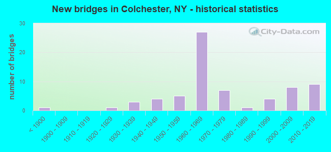
- New bridges - historical statistics
- 1Before 1900
- 11920-1929
- 31930-1939
- 41940-1949
- 51950-1959
- 271960-1969
- 71970-1979
- 11980-1989
- 41990-1999
- 82000-2009
- 92010-2019
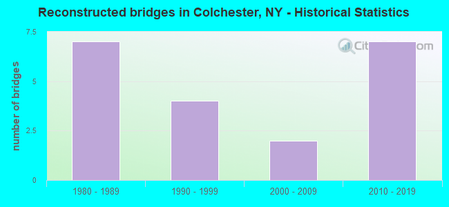
- Reconstructed bridges - Historical Statistics
- 71980-1989
- 41990-1999
- 22000-2009
- 72010-2019
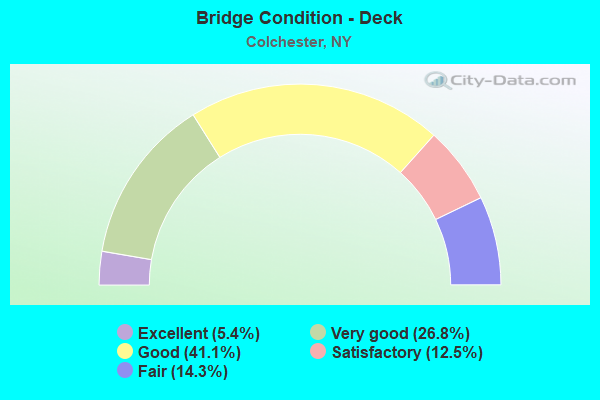
- Bridge Condition - Deck
- 5.4%Excellent
- 26.8%Very good
- 41.1%Good
- 12.5%Satisfactory
- 14.3%Fair
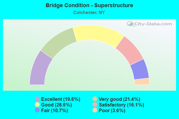
- Bridge Condition - Superstructure
- 19.6%Excellent
- 21.4%Very good
- 28.6%Good
- 16.1%Satisfactory
- 10.7%Fair
- 3.6%Poor
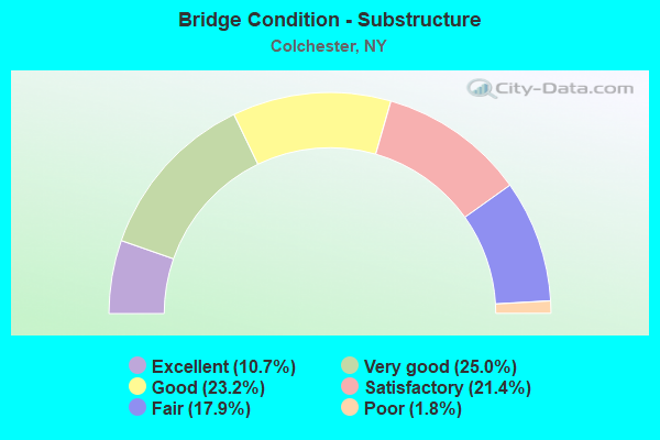
- Bridge Condition - Substructure
- 10.7%Excellent
- 25.0%Very good
- 23.2%Good
- 21.4%Satisfactory
- 17.9%Fair
- 1.8%Poor
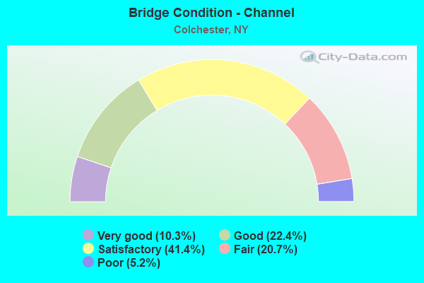
- Bridge Condition - Channel
- 10.3%Very good
- 22.4%Good
- 41.4%Satisfactory
- 20.7%Fair
- 5.2%Poor
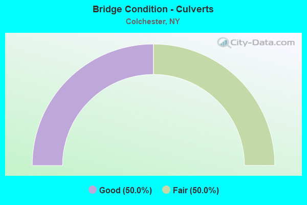
- Bridge Condition - Culverts
- 50.0%Good
- 50.0%Fair
Find on map >> Show street view
Structure Number: 335202, Location: 1.9 MI N OF HORTON (Lat: 41.998753, Lng: -75.005772), Route carried "on" structure: Other road , Year Built: 1957, Status: Open, Structure Length: 1.28m (4.20ft), Average Daily Traffic: 138 (year 2018), Truck Traffic: 6%, Average Future Daily Traffic: 193 (year 2038), Design Load: HS 20, Features Intersected: HORTON BROOK, Facility Carried by Structure: HORTON BROOK ROAD
Minimum Vertical Clearance: 30+ m (98+ ft), Kilometerpoint: 3.250, Lanes on structure: 2, Owner: County Highway Agency, Approaching Roadway Width: 4.6m (15.1ft), Skew: 4 degrees, Material/Design: Steel, Design/Construction: Stringer/Multi-beam, Number Of Spans In Main Unit: 1, Length of Maximum Span: 10.9m (35.8ft), Curb-To-Curb Width: 6.1m (20.0ft), Out-to-Out Width: 7.0m (23.0ft)
Condition: Deck: Fair, Superstructure: Satisfactory, Substructure: Fair, Channel: Fair, Operating Rating: 38.1 metric tons, Method Used To Determine Operating Rating: Load Factor (LF), Inventory Rating: 22.7 metric tons, Method Used To Determine Inventory Rating: Load Factor (LF), Structural Evaluation: Somewhat better than minimum adequacy, Deck Geometry: Meets minimum limits, Waterway Adequacy: Meets minimum limits, Approach Roadway Alignment: Somewhat better than minimum adequacy, Length Of Structure Improvement: 1.28m (4.20ft), Designated Inspection Frequency: Every 24 months, Inspection Date: June 2020, Bridge Improvement Cost: $369,000, Roadway Improvement Cost: $216,000, Total Project Cost: $585,000 ( Estimate for 2021), Deck Structure Type: Concrete Cast-file-Place, Wearing Surface/Protective System: Wearing Surface: Bituminous
Find on map >> Show street view
Structure Number: 335203, Location: 0.1 MI SE OF SH 30 (Lat: 42.039136, Lng: -75.067419), Route carried "on" structure: Other road , Year Built: 1992, Status: Open, Structure Length: 7.80m (25.59ft), Average Daily Traffic: 124 (year 2016), Truck Traffic: 21%, Average Future Daily Traffic: 174 (year 2036), Design Load: HS 20, Features Intersected: E BR DELAWARE RVR, Facility Carried by Structure: RIVER ROAD
Minimum Vertical Clearance: 30+ m (98+ ft), Kilometerpoint: 0.064, Lanes on structure: 2, Owner: County Highway Agency, Approaching Roadway Width: 6.7m (22.0ft), Material/Design: Steel continuous, Design/Construction: Stringer/Multi-beam, Number Of Spans In Main Unit: 2, Length of Maximum Span: 38.1m (125.0ft), Curb-To-Curb Width: 6.7m (22.0ft), Out-to-Out Width: 7.3m (24.0ft)
Condition: Deck: Very good, Superstructure: Very good, Substructure: Very good, Channel: Satisfactory, Operating Rating: 93.4 metric tons, Method Used To Determine Operating Rating: Load Factor (LF), Inventory Rating: 55.3 metric tons, Method Used To Determine Inventory Rating: Load Factor (LF), Structural Evaluation: Equal to present desirable criteria, Deck Geometry: Meets minimum limits, Waterway Adequacy: Somewhat better than minimum adequacy, Approach Roadway Alignment: Equal to present minimum criteria, Length Of Structure Improvement: 7.80m (25.59ft), Designated Inspection Frequency: Every 24 months, Inspection Date: October 2020, Bridge Improvement Cost: $1,385,000, Roadway Improvement Cost: $811,000, Total Project Cost: $2,196,000 ( Estimate for 2021), Deck Structure Type: Concrete Cast-file-Place, Wearing Surface/Protective System: Wearing Surface: Integral Concrete, Deck Protection: Epoxy Coated Reinforcing
Find on map >> Show street view
Structure Number: 335204, Location: 3.6 MI S OF DOWNSVILLE (Lat: 42.043058, Lng: -75.007150), Route carried "on" structure: Other road , Year Built: 1963, Status: Open, Structure Length: 1.22m (4.00ft), Average Daily Traffic: 43 (year 2017), Truck Traffic: 5%, Average Future Daily Traffic: 60 (year 2037), Design Load: HS 20, Features Intersected: CAMPBELL BROOK, Facility Carried by Structure: CAMPBELL BROOK RD
Minimum Vertical Clearance: 30+ m (98+ ft), Kilometerpoint: 1.303, Lanes on structure: 2, Owner: County Highway Agency, Approaching Roadway Width: 5.5m (18.0ft), Skew: 3 degrees, Material/Design: Steel, Design/Construction: Stringer/Multi-beam, Number Of Spans In Main Unit: 1, Length of Maximum Span: 10.9m (35.8ft), Curb-To-Curb Width: 6.1m (20.0ft), Out-to-Out Width: 7.0m (23.0ft)
Condition: Deck: Very good, Superstructure: Good, Substructure: Fair, Channel: Satisfactory, Operating Rating: 43.5 metric tons, Method Used To Determine Operating Rating: Load Factor (LF), Inventory Rating: 25.4 metric tons, Method Used To Determine Inventory Rating: Load Factor (LF), Structural Evaluation: Somewhat better than minimum adequacy, Deck Geometry: Somewhat better than minimum adequacy, Waterway Adequacy: Meets minimum limits, Approach Roadway Alignment: Equal to present minimum criteria, Length Of Structure Improvement: 1.21m (3.97ft), Designated Inspection Frequency: Every 24 months, Inspection Date: September 2020, Bridge Improvement Cost: $388,000, Roadway Improvement Cost: $227,000, Total Project Cost: $616,000 ( Estimate for 2021), Deck Structure Type: Concrete Cast-file-Place, Wearing Surface/Protective System: Wearing Surface: Bituminous
Find on map >> Show street view
Structure Number: 335205, Location: 3.7 MI S OF DOWNSVILLE (Lat: 42.041619, Lng: -74.989039), Route carried "on" structure: Other road , Year Built: 1964, Status: Open, Structure Length: 1.19m (3.90ft), Average Daily Traffic: 43 (year 2017), Truck Traffic: 5%, Average Future Daily Traffic: 60 (year 2037), Design Load: HS 20, Features Intersected: CAMPBELL BROOK, Facility Carried by Structure: CAMPBELL BROOK RD
Minimum Vertical Clearance: 30+ m (98+ ft), Kilometerpoint: 2.896, Lanes on structure: 2, Owner: County Highway Agency, Approaching Roadway Width: 6.1m (20.0ft), Skew: 4 degrees, Material/Design: Steel, Design/Construction: Stringer/Multi-beam, Number Of Spans In Main Unit: 1, Length of Maximum Span: 10.3m (33.8ft), Curb-To-Curb Width: 6.1m (20.0ft), Out-to-Out Width: 7.0m (23.0ft)
Condition: Deck: Very good, Superstructure: Good, Substructure: Fair, Channel: Satisfactory, Operating Rating: 43.5 metric tons, Method Used To Determine Operating Rating: Load Factor (LF), Inventory Rating: 26.3 metric tons, Method Used To Determine Inventory Rating: Load Factor (LF), Structural Evaluation: Somewhat better than minimum adequacy, Deck Geometry: Somewhat better than minimum adequacy, Waterway Adequacy: Somewhat better than minimum adequacy, Approach Roadway Alignment: Somewhat better than minimum adequacy, Length Of Structure Improvement: 1.18m (3.87ft), Designated Inspection Frequency: Every 24 months, Inspection Date: September 2020, Bridge Improvement Cost: $236,000, Roadway Improvement Cost: $138,000, Total Project Cost: $375,000 ( Estimate for 2021), Deck Structure Type: Concrete Cast-file-Place, Wearing Surface/Protective System: Wearing Surface: Bituminous
Find on map >> Show street view
Structure Number: 335206, Location: 1.2 MI SW OF COLCHESTER (Lat: 42.046358, Lng: -75.027503), Route carried "on" structure: Other road , Year Built: 1926, Year Reconstructed: 2006, Status: Posted for load, Structure Length: 6.49m (21.29ft), Average Daily Traffic: 439 (year 2016), Truck Traffic: 7%, Average Future Daily Traffic: 615 (year 2036), Features Intersected: E BR DELAWARE RVR, Facility Carried by Structure: CORBETT ROAD
Minimum Vertical Clearance: 4.31m (14.14ft), Kilometerpoint: 0.016, Lanes on structure: 1, Owner: County Highway Agency, Approaching Roadway Width: 3.0m (9.8ft), Material/Design: Steel, Design/Construction: Suspension, Number Of Spans In Main Unit: 1, Number Of Approach Spans: 2, Length of Maximum Span: 51.8m (169.9ft), Curb-To-Curb Width: 3.5m (11.5ft), Out-to-Out Width: 3.5m (11.5ft)
Condition: Deck: Fair, Superstructure: Poor, Substructure: Satisfactory, Channel: Good, Operating Rating: 16.3 metric tons, Method Used To Determine Operating Rating: Load Factor (LF), Inventory Rating: 11.8 metric tons, Method Used To Determine Inventory Rating: Load Factor (LF), Structural Evaluation: Meets minimum limits, Deck Geometry: High priority of replacement, Waterway Adequacy: Somewhat better than minimum adequacy, Approach Roadway Alignment: High priority of corrective action, Bridge Posting: Required (Relationship of Operating Rating to Maximum Legal Load: > 39.9% below), Length Of Structure Improvement: 6.49m (21.29ft), Designated Inspection Frequency: Every 12 months, Critical Feature Inspection Frequency: Every 12 months, Inspection Date: August 2021, Critical Feature Inspection Date: August 2021, Bridge Improvement Cost: $2,919,000, Roadway Improvement Cost: $1,710,000, Total Project Cost: $4,629,000 ( Estimate for 2021), Deck Structure Type: Open Grating, Wearing Surface/Protective System: Wearing Surface: Other
Find on map >> Show street view
Structure Number: 335207, Location: IN DOWNSVILLE (Lat: 42.076181, Lng: -74.990658), Route carried "on" structure: Other road , Year Built: 1857, Year Reconstructed: 1999, Status: Posted for load, Structure Length: 5.21m (17.09ft), Truck Traffic: 10%, Features Intersected: E BR DELAWARE RIVER, Facility Carried by Structure: BRIDGE STREET
Minimum Vertical Clearance: 3.68m (12.07ft), Kilometerpoint: 0.274, Lanes on structure: 1, Owner: County Highway Agency, Approaching Roadway Width: 4.3m (14.1ft), Material/Design: Wood or Timber, Design/Construction: Truss - Thru, Number Of Spans In Main Unit: 1, Length of Maximum Span: 51.8m (169.9ft), Curb-To-Curb Width: 4.2m (13.8ft), Out-to-Out Width: 4.9m (16.1ft)
Condition: Deck: Good, Superstructure: Fair, Substructure: Satisfactory, Channel: Good, Operating Rating: 2.7 metric tons, Method Used To Determine Operating Rating: Field evaluation and documented engineering judgment, Inventory Rating: 2.7 metric tons, Method Used To Determine Inventory Rating: Field evaluation and documented engineering judgment, Structural Evaluation: High priority of corrective action, Deck Geometry: High priority of corrective action, Waterway Adequacy: Somewhat better than minimum adequacy, Approach Roadway Alignment: Equal to present minimum criteria, Bridge Posting: Required (Relationship of Operating Rating to Maximum Legal Load: > 39.9% below), Length Of Structure Improvement: 5.21m (17.09ft), Designated Inspection Frequency: Every 12 months, Critical Feature Inspection Frequency: Every 12 months, Inspection Date: June 2021, Critical Feature Inspection Date: June 2021, Bridge Improvement Cost: $1,722,000, Roadway Improvement Cost: $1,008,000, Total Project Cost: $2,730,000 ( Estimate for 2021), Deck Structure Type: Wood or Timber, Wearing Surface/Protective System: Wearing Surface: Wood or Timber
Find on map >> Show street view
Structure Number: 335208, Location: IN DOWNSVILLE (Lat: 42.083939, Lng: -74.995142), Route carried "on" structure: Other road , Year Built: 1948, Status: Open, Structure Length: 1.16m (3.81ft), Truck Traffic: 8%, Features Intersected: WILSON HOLLOW BRK, Facility Carried by Structure: KNOX AVENUE
Minimum Vertical Clearance: 30+ m (98+ ft), Kilometerpoint: 0.225, Lanes on structure: 2, Owner: County Highway Agency, Approaching Roadway Width: 6.7m (22.0ft), Skew: 1 degrees, Material/Design: Concrete, Design/Construction: Slab, Number Of Spans In Main Unit: 1, Length of Maximum Span: 11.2m (36.7ft), Curb or Sidewalk Widths: Left: 0.8m (2.6ft), Right: 0.8m (2.6ft), Curb-To-Curb Width: 7.3m (24.0ft), Out-to-Out Width: 9.3m (30.5ft)
Condition: Deck: Fair, Superstructure: Fair, Substructure: Satisfactory, Channel: Fair, Operating Rating: 49.0 metric tons, Method Used To Determine Operating Rating: Load Factor (LF), Inventory Rating: 29.0 metric tons, Method Used To Determine Inventory Rating: Load Factor (LF), Structural Evaluation: Somewhat better than minimum adequacy, Deck Geometry: Equal to present minimum criteria, Waterway Adequacy: Meets minimum limits, Approach Roadway Alignment: Better than present minimum criteria, Length Of Structure Improvement: 1.15m (3.77ft), Designated Inspection Frequency: Every 24 months, Inspection Date: April 2021, Bridge Improvement Cost: $501,000, Roadway Improvement Cost: $293,000, Total Project Cost: $794,000 ( Estimate for 2021), Wearing Surface/Protective System: Wearing Surface: Bituminous
Find on map >> Show street view
Structure Number: 335209, Location: 1.5 MI NE OF DOWNSVILLE (Lat: 42.098339, Lng: -74.978736), Route carried "on" structure: Other road , Year Built: 1953, Status: Open, Structure Length: 1.31m (4.30ft), Average Daily Traffic: 207 (year 2017), Truck Traffic: 5%, Average Future Daily Traffic: 290 (year 2037), Design Load: HS 20, Features Intersected: DOWNS BROOK, Facility Carried by Structure: GREGORY HOLLOW RD
Minimum Vertical Clearance: 30+ m (98+ ft), Kilometerpoint: 0.692, Lanes on structure: 2, Owner: County Highway Agency, Approaching Roadway Width: 6.1m (20.0ft), Skew: 4 degrees, Material/Design: Steel, Design/Construction: Stringer/Multi-beam, Number Of Spans In Main Unit: 1, Length of Maximum Span: 11.5m (37.7ft), Curb-To-Curb Width: 6.1m (20.0ft), Out-to-Out Width: 7.0m (23.0ft)
Condition: Deck: Fair, Superstructure: Satisfactory, Substructure: Fair, Channel: Fair, Operating Rating: 42.6 metric tons, Method Used To Determine Operating Rating: Load Factor (LF), Inventory Rating: 25.4 metric tons, Method Used To Determine Inventory Rating: Load Factor (LF), Structural Evaluation: Somewhat better than minimum adequacy, Deck Geometry: Meets minimum limits, Waterway Adequacy: Meets minimum limits, Approach Roadway Alignment: Equal to present minimum criteria, Length Of Structure Improvement: 1.31m (4.30ft), Designated Inspection Frequency: Every 24 months, Inspection Date: July 2021, Bridge Improvement Cost: $325,000, Roadway Improvement Cost: $191,000, Total Project Cost: $516,000 ( Estimate for 2021), Deck Structure Type: Concrete Cast-file-Place, Wearing Surface/Protective System: Wearing Surface: Bituminous
Find on map >> Show street view
Structure Number: 335355, Location: 0.5 MI N OF HORTON (Lat: 41.979231, Lng: -75.014586), Route carried "on" structure: Other road , Year Built: 1971, Status: Open, Structure Length: 1.68m (5.51ft), Average Daily Traffic: 153 (year 2017), Truck Traffic: 6%, Average Future Daily Traffic: 214 (year 2037), Design Load: HS 20, Features Intersected: HORTON BROOK, Facility Carried by Structure: HORTON BROOK ROAD
Minimum Vertical Clearance: 30+ m (98+ ft), Kilometerpoint: 0.740, Lanes on structure: 2, Owner: County Highway Agency, Approaching Roadway Width: 4.6m (15.1ft), Skew: 4 degrees, Material/Design: Steel, Design/Construction: Stringer/Multi-beam, Number Of Spans In Main Unit: 1, Length of Maximum Span: 15.5m (50.9ft), Curb-To-Curb Width: 8.2m (26.9ft), Out-to-Out Width: 8.8m (28.9ft)
Condition: Deck: Good, Superstructure: Good, Substructure: Poor, Channel: Fair, Inventory Rating: 64.4 metric tons, Method Used To Determine Inventory Rating: Load Factor (LF), Structural Evaluation: Meets minimum limits, Deck Geometry: Somewhat better than minimum adequacy, Waterway Adequacy: Meets minimum limits, Approach Roadway Alignment: Equal to present desirable criteria, Length Of Structure Improvement: 1.67m (5.48ft), Designated Inspection Frequency: Every 24 months, Inspection Date: June 2021, Bridge Improvement Cost: $484,000, Roadway Improvement Cost: $284,000, Total Project Cost: $768,000 ( Estimate for 2021), Deck Structure Type: Concrete Cast-file-Place, Wearing Surface/Protective System: Wearing Surface: Bituminous
Find on map >> Show street view
Structure Number: 335357, Location: 1.8 MI N OF HORTON (Lat: 41.994892, Lng: -75.007147), Route carried "on" structure: Other road , Year Built: 1972, Status: Open, Structure Length: 1.65m (5.41ft), Average Daily Traffic: 138 (year 2018), Truck Traffic: 6%, Average Future Daily Traffic: 193 (year 2038), Design Load: HS 20, Features Intersected: HORTON BROOK, Facility Carried by Structure: HORTON BROOK ROAD
Minimum Vertical Clearance: 30+ m (98+ ft), Kilometerpoint: 2.784, Lanes on structure: 2, Owner: County Highway Agency, Approaching Roadway Width: 4.6m (15.1ft), Skew: 5 degrees, Material/Design: Steel, Design/Construction: Girder and Floorbeam System, Number Of Spans In Main Unit: 1, Length of Maximum Span: 14.9m (48.9ft), Curb-To-Curb Width: 7.9m (25.9ft), Out-to-Out Width: 8.6m (28.2ft)
Condition: Deck: Very good, Superstructure: Good, Substructure: Satisfactory, Channel: Fair, Operating Rating: 49.0 metric tons, Method Used To Determine Operating Rating: Load Factor (LF), Inventory Rating: 29.0 metric tons, Method Used To Determine Inventory Rating: Load Factor (LF), Structural Evaluation: Equal to present minimum criteria, Deck Geometry: Somewhat better than minimum adequacy, Waterway Adequacy: Somewhat better than minimum adequacy, Approach Roadway Alignment: Equal to present desirable criteria, Length Of Structure Improvement: 1.64m (5.38ft), Designated Inspection Frequency: Every 24 months, Inspection Date: August 2020, Bridge Improvement Cost: $632,000, Roadway Improvement Cost: $370,000, Total Project Cost: $1,003,000 ( Estimate for 2021), Deck Structure Type: Concrete Cast-file-Place, Wearing Surface/Protective System: Wearing Surface: Bituminous
Find on map >> Show street view
Structure Number: 335361, Location: AT HORTON (Lat: 41.972953, Lng: -75.016889), Route carried "on" structure: County highway , Year Built: 2000, Status: Open, Structure Length: 1.01m (3.31ft), Average Daily Traffic: 308 (year 2020), Truck Traffic: 12%, Average Future Daily Traffic: 431 (year 2040), Design Load: HS 25 or greater, Features Intersected: HORTON BROOK, Facility Carried by Structure: COUNTY ROAD 17
Minimum Vertical Clearance: 30+ m (98+ ft), Kilometerpoint: 27.562, Lanes on structure: 2, Owner: County Highway Agency, Approaching Roadway Width: 9.1m (29.9ft), Material/Design: Steel, Design/Construction: Stringer/Multi-beam, Number Of Spans In Main Unit: 1, Length of Maximum Span: 9.8m (32.2ft), Curb-To-Curb Width: 9.1m (29.9ft), Out-to-Out Width: 10.1m (33.1ft)
Condition: Deck: Very good, Superstructure: Very good, Substructure: Excellent, Channel: Satisfactory, Inventory Rating: 69.9 metric tons, Method Used To Determine Inventory Rating: Load Factor (LF), Structural Evaluation: Equal to present desirable criteria, Deck Geometry: Equal to present minimum criteria, Waterway Adequacy: Somewhat better than minimum adequacy, Approach Roadway Alignment: Equal to present minimum criteria, Length Of Structure Improvement: 1.00m (3.28ft), Designated Inspection Frequency: Every 24 months, Inspection Date: September 2020, Bridge Improvement Cost: $300,000, Roadway Improvement Cost: $176,000, Total Project Cost: $476,000 ( Estimate for 2021), Deck Structure Type: Concrete Cast-file-Place, Wearing Surface/Protective System: Wearing Surface: Bituminous, Deck Protection: Epoxy Coated Reinforcing
Find on map >> Show street view
Structure Number: 335362, Location: IN COOKS FALLS (Lat: 41.958439, Lng: -74.991583), Route carried "on" structure: County highway , Year Built: 1938, Year Reconstructed: 1995, Status: Open, Structure Length: 0.98m (3.22ft), Average Daily Traffic: 211 (year 2020), Truck Traffic: 8%, Average Future Daily Traffic: 295 (year 2040), Features Intersected: RUSSELL BROOK, Facility Carried by Structure: COUNTY ROAD 17
Minimum Vertical Clearance: 30+ m (98+ ft), Kilometerpoint: 30.249, Lanes on structure: 2, Owner: County Highway Agency, Approaching Roadway Width: 6.1m (20.0ft), Skew: 1 degrees, Material/Design: Steel, Design/Construction: Stringer/Multi-beam, Number Of Spans In Main Unit: 1, Length of Maximum Span: 9.1m (29.9ft), Curb-To-Curb Width: 8.5m (27.9ft), Out-to-Out Width: 9.4m (30.8ft)
Condition: Deck: Very good, Superstructure: Very good, Substructure: Fair, Channel: Fair, Operating Rating: 78.9 metric tons, Method Used To Determine Operating Rating: Load Factor (LF), Inventory Rating: 47.2 metric tons, Method Used To Determine Inventory Rating: Load Factor (LF), Structural Evaluation: Somewhat better than minimum adequacy, Deck Geometry: Equal to present minimum criteria, Waterway Adequacy: Meets minimum limits, Approach Roadway Alignment: Equal to present desirable criteria, Length Of Structure Improvement: 0.97m (3.18ft), Designated Inspection Frequency: Every 24 months, Inspection Date: August 2021, Bridge Improvement Cost: $462,000, Roadway Improvement Cost: $271,000, Total Project Cost: $733,000 ( Estimate for 2021), Deck Structure Type: Concrete Cast-file-Place, Wearing Surface/Protective System: Wearing Surface: Bituminous
Find on map >> Show street view
Structure Number: 335943, Location: 4.5 MILES N OF ROCKLAND (Lat: 41.968614, Lng: -74.898586), Route carried "on" structure: County highway 206, Year Built: 2010, Status: Open, Structure Length: 2.70m (8.86ft), Average Daily Traffic: 1,637 (year 2018), Truck Traffic: 9%, Average Future Daily Traffic: 1,707 (year 2040), Design Load: HL 93, Features Intersected: SPRING BROOK
Minimum Vertical Clearance: 30+ m (98+ ft), Kilometerpoint: 63.974, Lanes on structure: 2, Base Highway Network: Yes, Owner: County Highway Agency, Approaching Roadway Width: 13.4m (44.0ft), Skew: 3 degrees, Material/Design: Prestressed concrete, Design/Construction: Box Beam or Girders - Multiple, Number Of Spans In Main Unit: 1, Length of Maximum Span: 25.6m (84.0ft), Curb-To-Curb Width: 13.3m (43.6ft), Out-to-Out Width: 14.3m (46.9ft)
Condition: Deck: Good, Superstructure: Excellent, Substructure: Very good, Channel: Good, Operating Rating: 96.2 metric tons, Method Used To Determine Operating Rating: Load Factor (LF), Inventory Rating: 35.4 metric tons, Method Used To Determine Inventory Rating: Load Factor (LF), Structural Evaluation: Equal to present desirable criteria, Deck Geometry: Better than present minimum criteria, Waterway Adequacy: Equal to present minimum criteria, Approach Roadway Alignment: Equal to present desirable criteria, Length Of Structure Improvement: 2.70m (8.86ft), Designated Inspection Frequency: Every 24 months, Inspection Date: November 2020, Bridge Improvement Cost: $995,000, Roadway Improvement Cost: $583,000, Total Project Cost: $1,578,000 ( Estimate for 2021), Wearing Surface/Protective System: Wearing Surface: Integral Concrete
Find on map >> Show street view
Structure Number: 336942, Location: IN HORTON (Lat: 41.972236, Lng: -75.016750), Route carried "on" structure: Other road , Year Built: 1999, Status: Open, Structure Length: 6.22m (20.41ft), Average Daily Traffic: 86 (year 2019), Truck Traffic: 5%, Average Future Daily Traffic: 120 (year 2039), Features Intersected: BEAVER KILL, Facility Carried by Structure: CHILOWAY ROAD
Minimum Vertical Clearance: 30+ m (98+ ft), Kilometerpoint: 1.303, Lanes on structure: 2, Owner: County Highway Agency, Approaching Roadway Width: 6.7m (22.0ft), Material/Design: Steel continuous, Design/Construction: Stringer/Multi-beam, Number Of Spans In Main Unit: 2, Length of Maximum Span: 30.7m (100.7ft), Curb-To-Curb Width: 6.6m (21.7ft), Out-to-Out Width: 7.6m (24.9ft)
Condition: Deck: Very good, Superstructure: Excellent, Substructure: Very good, Channel: Very good, Operating Rating: 79.8 metric tons, Method Used To Determine Operating Rating: Load Factor (LF), Inventory Rating: 48.1 metric tons, Method Used To Determine Inventory Rating: Load Factor (LF), Structural Evaluation: Equal to present desirable criteria, Deck Geometry: Somewhat better than minimum adequacy, Waterway Adequacy: Equal to present minimum criteria, Approach Roadway Alignment: High priority of corrective action, Length Of Structure Improvement: 6.21m (20.37ft), Designated Inspection Frequency: Every 24 months, Inspection Date: August 2021, Bridge Improvement Cost: $1,226,000, Roadway Improvement Cost: $718,000, Total Project Cost: $1,944,000 ( Estimate for 2021), Deck Structure Type: Concrete Cast-file-Place, Wearing Surface/Protective System: Wearing Surface: Integral Concrete, Deck Protection: Epoxy Coated Reinforcing
Find on map >> Show street view
Structure Number: 337064, Location: Little Spring Brook Rd (Lat: 42.017872, Lng: -74.889125), Route carried "on" structure: County highway , Year Built: 2010, Status: Open, Structure Length: 1.49m (4.89ft), Average Daily Traffic: 11 (year 2019), Average Future Daily Traffic: 15 (year 2039), Features Intersected: Little Spring Brk, Facility Carried by Structure: Little SpringBkRd
Minimum Vertical Clearance: 30+ m (98+ ft), Kilometerpoint: 0.370, Lanes on structure: 2, Owner: County Highway Agency, Approaching Roadway Width: 7.3m (24.0ft), Skew: 3 degrees, Material/Design: Steel, Design/Construction: Stringer/Multi-beam, Number Of Spans In Main Unit: 1, Length of Maximum Span: 14.6m (47.9ft), Curb-To-Curb Width: 7.3m (24.0ft), Out-to-Out Width: 7.5m (24.6ft)
Condition: Deck: Good, Superstructure: Excellent, Substructure: Very good, Channel: Satisfactory, Operating Rating: 75.3 metric tons, Method Used To Determine Operating Rating: Load Factor (LF), Inventory Rating: 45.4 metric tons, Method Used To Determine Inventory Rating: Load Factor (LF), Structural Evaluation: Equal to present desirable criteria, Deck Geometry: Equal to present minimum criteria, Waterway Adequacy: Somewhat better than minimum adequacy, Approach Roadway Alignment: Equal to present minimum criteria, Length Of Structure Improvement: 1.49m (4.89ft), Designated Inspection Frequency: Every 24 months, Inspection Date: October 2021, Bridge Improvement Cost: $514,000, Roadway Improvement Cost: $301,000, Total Project Cost: $815,000 ( Estimate for 2021), Deck Structure Type: Wood or Timber, Wearing Surface/Protective System: Wearing Surface: Bituminous
Find on map >> Show street view
Structure Number: 33707, Location: 1.3 mi N Rt30 (Lat: 42.058608, Lng: -75.064478), Route carried "on" structure: County highway , Year Built: 2010, Status: Open, Structure Length: 0.73m (2.40ft), Average Daily Traffic: 167 (year 2016), Truck Traffic: 8%, Average Future Daily Traffic: 234 (year 2036), Features Intersected: West Trout Brook, Facility Carried by Structure: Trout Brook Road
Minimum Vertical Clearance: 30+ m (98+ ft), Kilometerpoint: 2.204, Lanes on structure: 2, Owner: County Highway Agency, Approaching Roadway Width: 7.3m (24.0ft), Skew: 2 degrees, Material/Design: Concrete, Design/Construction: Slab, Number Of Spans In Main Unit: 1, Length of Maximum Span: 6.7m (22.0ft), Curb-To-Curb Width: 7.3m (24.0ft), Out-to-Out Width: 8.3m (27.2ft)
Condition: Deck: Excellent, Superstructure: Very good, Substructure: Very good, Channel: Very good, Operating Rating: 77.3 metric tons, Method Used To Determine Operating Rating: Field evaluation and documented engineering judgment, Inventory Rating: 40.8 metric tons, Method Used To Determine Inventory Rating: Field evaluation and documented engineering judgment, Structural Evaluation: Equal to present desirable criteria, Deck Geometry: Somewhat better than minimum adequacy, Waterway Adequacy: Equal to present minimum criteria, Approach Roadway Alignment: Meets minimum limits, Length Of Structure Improvement: 0.73m (2.40ft), Designated Inspection Frequency: Every 24 months, Inspection Date: August 2021, Bridge Improvement Cost: $182,000, Roadway Improvement Cost: $106,000, Total Project Cost: $288,000 ( Estimate for 2021), Wearing Surface/Protective System: Wearing Surface: Bituminous
Find on map >> Show street view
Structure Number: 337071, Location: 1.2 mi N Rt 30 (Lat: 42.057058, Lng: -75.064619), Route carried "on" structure: County highway , Year Built: 2010, Status: Open, Structure Length: 1.31m (4.30ft), Average Daily Traffic: 167 (year 2016), Truck Traffic: 8%, Average Future Daily Traffic: 234 (year 2036), Features Intersected: Trout Brook, Facility Carried by Structure: Trout Brook Road
Minimum Vertical Clearance: 30+ m (98+ ft), Kilometerpoint: 2.027, Lanes on structure: 2, Owner: County Highway Agency, Approaching Roadway Width: 7.9m (25.9ft), Skew: 3 degrees, Material/Design: Prestressed concrete, Design/Construction: Box Beam or Girders - Multiple, Number Of Spans In Main Unit: 1, Length of Maximum Span: 12.5m (41.0ft), Curb-To-Curb Width: 7.9m (25.9ft), Out-to-Out Width: 9.0m (29.5ft)
Condition: Deck: Very good, Superstructure: Excellent, Substructure: Very good, Channel: Satisfactory, Operating Rating: 81.5 metric tons, Method Used To Determine Operating Rating: Field evaluation and documented engineering judgment, Inventory Rating: 40.8 metric tons, Method Used To Determine Inventory Rating: Field evaluation and documented engineering judgment, Structural Evaluation: Equal to present desirable criteria, Deck Geometry: Somewhat better than minimum adequacy, Waterway Adequacy: Somewhat better than minimum adequacy, Approach Roadway Alignment: Somewhat better than minimum adequacy, Length Of Structure Improvement: 1.31m (4.30ft), Designated Inspection Frequency: Every 24 months, Inspection Date: August 2021, Bridge Improvement Cost: $239,000, Roadway Improvement Cost: $140,000, Total Project Cost: $379,000 ( Estimate for 2021), Deck Structure Type: Concrete Cast-file-Place, Wearing Surface/Protective System: Wearing Surface: Monolithic Concrete, Deck Protection: Epoxy Coated Reinforcing
Find on map >> Show street view
Structure Number: 337072, Location: 2.5 mi E Rt 206 (Lat: 41.994506, Lng: -74.844558), Route carried "on" structure: County highway , Year Built: 2010, Status: Open, Structure Length: 1.19m (3.90ft), Average Daily Traffic: 55 (year 2018), Average Future Daily Traffic: 77 (year 2038), Features Intersected: Berry Brook, Facility Carried by Structure: Holiday and Berry
Minimum Vertical Clearance: 30+ m (98+ ft), Kilometerpoint: 1.319, Lanes on structure: 2, Owner: County Highway Agency, Approaching Roadway Width: 7.6m (24.9ft), Skew: 3 degrees, Material/Design: Steel, Design/Construction: Stringer/Multi-beam, Number Of Spans In Main Unit: 1, Length of Maximum Span: 11.6m (38.1ft), Curb-To-Curb Width: 7.5m (24.6ft), Out-to-Out Width: 7.6m (24.9ft)
Condition: Deck: Very good, Superstructure: Excellent, Substructure: Excellent, Channel: Good, Operating Rating: 59.9 metric tons, Method Used To Determine Operating Rating: Load Factor (LF), Inventory Rating: 35.4 metric tons, Method Used To Determine Inventory Rating: Load Factor (LF), Structural Evaluation: Superior to present desirable criteria, Deck Geometry: Equal to present minimum criteria, Waterway Adequacy: Somewhat better than minimum adequacy, Approach Roadway Alignment: Meets minimum limits, Length Of Structure Improvement: 1.18m (3.87ft), Designated Inspection Frequency: Every 24 months, Inspection Date: October 2021, Bridge Improvement Cost: $455,000, Roadway Improvement Cost: $266,000, Total Project Cost: $721,000 ( Estimate for 2021), Deck Structure Type: Wood or Timber, Wearing Surface/Protective System: Wearing Surface: Bituminous
Find on map >> Show street view
Structure Number: 337114, Location: Cooks Falls (Lat: 41.955758, Lng: -74.990128), Route carried "on" structure: County highway , Year Built: 1965, Status: Open, Structure Length: 0.64m (2.10ft), Truck Traffic: 5%, Features Intersected: Unnamed Creek, Facility Carried by Structure: COOKS FALLS ROAD
Minimum Vertical Clearance: 30+ m (98+ ft), Kilometerpoint: 0.274, Lanes on structure: 2, Owner: County Highway Agency, Approaching Roadway Width: 7.3m (24.0ft), Material/Design: Steel, Design/Construction: Culvert, Number Of Spans In Main Unit: 3, Length of Maximum Span: 1.8m (5.9ft)
Condition: Channel: Fair, Culverts: Good, Operating Rating: 73.8 metric tons, Method Used To Determine Operating Rating: Field evaluation and documented engineering judgment, Inventory Rating: 32.7 metric tons, Method Used To Determine Inventory Rating: Field evaluation and documented engineering judgment, Structural Evaluation: Better than present minimum criteria, Waterway Adequacy: Somewhat better than minimum adequacy, Approach Roadway Alignment: Equal to present desirable criteria, Length Of Structure Improvement: 0.64m (2.10ft), Designated Inspection Frequency: Every 24 months, Inspection Date: October 2020, Bridge Improvement Cost: $83,000, Roadway Improvement Cost: $49,000, Total Project Cost: $132,000 ( Estimate for 2021)
Find on map >> Show street view
Structure Number: 552489, Location: 0.5 mi from Morton Hill R (Lat: 41.995139, Lng: -74.941206), Route carried "on" structure: ServiceState lands road , Year Built: 2007, Status: Posted for load, Structure Length: 1.43m (4.69ft), Design Load: H 15, Features Intersected: Russell Brook, Facility Carried by Structure: DEC Access Rd
Minimum Vertical Clearance: 30+ m (98+ ft), Kilometerpoint: 0.032, Lanes on structure: 1, Owner: State Agenciy, Approaching Roadway Width: 3.7m (12.1ft), Material/Design: Steel, Design/Construction: Stringer/Multi-beam, Number Of Spans In Main Unit: 1, Length of Maximum Span: 14.0m (45.9ft), Curb-To-Curb Width: 3.7m (12.1ft), Out-to-Out Width: 3.9m (12.8ft)
Condition: Deck: Good, Superstructure: Very good, Substructure: Very good, Channel: Good, Operating Rating: 24.5 metric tons, Method Used To Determine Operating Rating: Load Factor (LF), Inventory Rating: 14.5 metric tons, Method Used To Determine Inventory Rating: Load Factor (LF), Structural Evaluation: Meets minimum limits, Deck Geometry: Meets minimum limits, Waterway Adequacy: Somewhat better than minimum adequacy, Approach Roadway Alignment: Equal to present minimum criteria, Bridge Posting: Required (Relationship of Operating Rating to Maximum Legal Load: > 39.9% below), Length Of Structure Improvement: 1.43m (4.69ft), Designated Inspection Frequency: Every 12 months, Inspection Date: August 2021, Bridge Improvement Cost: $111,000, Roadway Improvement Cost: $65,000, Total Project Cost: $175,000 ( Estimate for 2021), Deck Structure Type: Wood or Timber, Wearing Surface/Protective System: Wearing Surface: Wood or Timber
Find on map >> Show street view
Structure Number: 55249, Location: 0.5mi from Morton Hill Rd (Lat: 41.996211, Lng: -74.942119), Route carried "on" structure: ServiceState lands road , Year Built: 2007, Status: Posted for load, Structure Length: 0.91m (2.99ft), Average Daily Traffic: 30 (year 2007), Average Future Daily Traffic: 42 (year 2027), Design Load: H 15, Features Intersected: Mud Pond, Facility Carried by Structure: DEC Access Rd
Minimum Vertical Clearance: 30+ m (98+ ft), Kilometerpoint: 0.000, Lanes on structure: 1, Owner: State Agenciy, Approaching Roadway Width: 3.0m (9.8ft), Material/Design: Steel, Design/Construction: Stringer/Multi-beam, Number Of Spans In Main Unit: 1, Length of Maximum Span: 8.5m (27.9ft), Curb-To-Curb Width: 2.9m (9.5ft), Out-to-Out Width: 3.1m (10.2ft)
Condition: Deck: Good, Superstructure: Good, Substructure: Very good, Channel: Fair, Operating Rating: 37.2 metric tons, Method Used To Determine Operating Rating: Load Factor (LF), Inventory Rating: 22.7 metric tons, Method Used To Determine Inventory Rating: Load Factor (LF), Structural Evaluation: Equal to present minimum criteria, Deck Geometry: High priority of replacement, Waterway Adequacy: Meets minimum limits, Approach Roadway Alignment: Equal to present desirable criteria, Bridge Posting: Required (Relationship of Operating Rating to Maximum Legal Load: > 39.9% below), Length Of Structure Improvement: 0.91m (2.99ft), Designated Inspection Frequency: Every 12 months, Inspection Date: August 2021, Bridge Improvement Cost: $56,000, Roadway Improvement Cost: $33,000, Total Project Cost: $88,000 ( Estimate for 2021), Deck Structure Type: Wood or Timber, Wearing Surface/Protective System: Wearing Surface: Wood or Timber
Find on map >> Show street view
Structure Number: 1054941, Location: EXIT 92 OF SH 17 (Lat: 41.970467, Lng: -75.021569), Route carried "under" structure: County highway , Year Built: 1968, Structure Length: 0. m, Average Daily Traffic: 259 (year 2015), Features Intersected: CR 17, BEAVER KILL, Facility Carried by Structure: RTE 17
Minimum Vertical Clearance: 5.92m (19.42ft), Kilometerpoint: 0.000, Lanes on structure: 2, Lanes under structure: 2, Material/Design: Steel, Design/Construction: Stringer/Multi-beam, Length of Maximum Span: 54.9m (180.1ft)
Find on map >> Show street view
Structure Number: 1054942, Location: EXIT 92 RTE 17 INT (Lat: 41.970242, Lng: -75.022283), Route carried "under" structure: County highway , Year Built: 1968, Structure Length: 0. m, Average Daily Traffic: 259 (year 2015), Features Intersected: CR 17, BEAVER KILL, Facility Carried by Structure: RTE 17
Minimum Vertical Clearance: 6.25m (20.51ft), Kilometerpoint: 0.000, Lanes on structure: 2, Lanes under structure: 2, Material/Design: Steel, Design/Construction: Stringer/Multi-beam, Length of Maximum Span: 54.9m (180.1ft)
Find on map >> Show street view
Structure Number: 1054951, Location: 0.5 MI E EXIT 92 - SH 17 (Lat: 41.969964, Lng: -75.014758), Route carried "under" structure: County highway , Year Built: 1968, Structure Length: 0. m, Features Intersected: CR 17, BEAVER KILL, Chil, Facility Carried by Structure: RTE 17
Minimum Vertical Clearance: 5.05m (16.57ft), Kilometerpoint: 0.000, Lanes on structure: 2, Lanes under structure: 2, Material/Design: Steel, Design/Construction: Stringer/Multi-beam, Length of Maximum Span: 42.9m (140.7ft)
Find on map >> Show street view
Structure Number: 1054952, Location: 0.5 MI E EXIT 92 RTE 17 (Lat: 41.969572, Lng: -75.014431), Route carried "under" structure: County highway , Year Built: 1968, Structure Length: 0. m, Features Intersected: CR 17, BEAVER KILL, Chil, Facility Carried by Structure: RTE 17
Minimum Vertical Clearance: 4.78m (15.68ft), Kilometerpoint: 0.000, Lanes on structure: 2, Lanes under structure: 2, Material/Design: Steel, Design/Construction: Stringer/Multi-beam, Length of Maximum Span: 42.9m (140.7ft)
Find on map >> Show street view
Structure Number: 1054961, Location: 3.9 MI NW SULLIVAN CO LN (Lat: 41.959111, Lng: -74.990736), Route carried "under" structure: Other road , Year Built: 1968, Structure Length: 0. m, Features Intersected: RUSSEL BROOK ROAD, RUSSE, Facility Carried by Structure: RTE 17
Minimum Vertical Clearance: 10.51m (34.48ft), Kilometerpoint: 0.000, Lanes on structure: 2, Lanes under structure: 2, Material/Design: Steel, Design/Construction: Stringer/Multi-beam, Length of Maximum Span: 39.6m (129.9ft)
Find on map >> Show street view
Structure Number: 1054962, Location: 3.9 MI NW SULLIVAN CL (Lat: 41.958836, Lng: -74.990894), Route carried "under" structure: Other road , Year Built: 1968, Structure Length: 0. m, Features Intersected: RUSSELL BROOK RD, RUSSEL, Facility Carried by Structure: RTE 17
Minimum Vertical Clearance: 9.85m (32.32ft), Kilometerpoint: 0.000, Lanes on structure: 2, Lanes under structure: 2, Material/Design: Steel continuous, Design/Construction: Stringer/Multi-beam, Length of Maximum Span: 39.6m (129.9ft)
Find on map >> Show street view
Structure Number: 1054971, Location: 2.7 MI NW SULLIVAN CL (Lat: 41.952083, Lng: -74.971553), Route carried "under" structure: Other road , Year Built: 1968, Structure Length: 0. m, Features Intersected: COOK FALLS ROAD, BEAVER, Facility Carried by Structure: RTE 17
Minimum Vertical Clearance: 5.66m (18.57ft), Kilometerpoint: 2.574, Lanes on structure: 2, Lanes under structure: 2, Material/Design: Steel, Design/Construction: Stringer/Multi-beam, Length of Maximum Span: 40.2m (131.9ft)
Find on map >> Show street view
Structure Number: 1054972, Location: 2.7 MI NW SULLIVAN CL (Lat: 41.951808, Lng: -74.971053), Route carried "under" structure: Other road , Year Built: 1968, Structure Length: 0. m, Features Intersected: COOK FALLS ROAD, BEAVER, Facility Carried by Structure: RTE 17
Minimum Vertical Clearance: 5.64m (18.50ft), Kilometerpoint: 1.673, Lanes on structure: 2, Lanes under structure: 2, Material/Design: Steel, Design/Construction: Stringer/Multi-beam, Length of Maximum Span: 42.9m (140.7ft)
Find on map >> Show street view
Structure Number: 1054981, Location: 2.4 MI NW SULLIVAN CO LN (Lat: 41.950494, Lng: -74.965869), Route carried "under" structure: County highway , Year Built: 1968, Structure Length: 0. m, Features Intersected: CR 17, BEAVER KILL, Facility Carried by Structure: RTE 17
Minimum Vertical Clearance: 9.99m (32.78ft), Kilometerpoint: 0.000, Lanes on structure: 2, Lanes under structure: 2, Material/Design: Steel, Design/Construction: Stringer/Multi-beam, Length of Maximum Span: 61.0m (200.1ft)
Find on map >> Show street view
Structure Number: 1054982, Location: 2.4 MI NW SULLIVAN CL (Lat: 41.950144, Lng: -74.965481), Route carried "under" structure: County highway , Year Built: 1968, Structure Length: 0. m, Features Intersected: CR 17, BEAVER KILL, Facility Carried by Structure: RTE 17
Minimum Vertical Clearance: 9.99m (32.78ft), Kilometerpoint: 0.000, Lanes on structure: 2, Lanes under structure: 2, Material/Design: Steel, Design/Construction: Stringer/Multi-beam, Length of Maximum Span: 61.0m (200.1ft)
Find on map >> Show street view
Structure Number: 1054991, Location: 0.6MI N SULLIVAN CL (Lat: 41.956056, Lng: -74.936194), Route carried "under" structure: County highway , Year Built: 1968, Structure Length: 0. m, Features Intersected: CR 17, BEAVER KILL, Facility Carried by Structure: RTE 17
Minimum Vertical Clearance: 4.92m (16.14ft), Kilometerpoint: 0.000, Lanes on structure: 2, Lanes under structure: 2, Material/Design: Steel, Design/Construction: Stringer/Multi-beam, Length of Maximum Span: 42.0m (137.8ft)
Find on map >> Show street view
Structure Number: 1054992, Location: 0.6MI N SULLIVAN CL (Lat: 41.955961, Lng: -74.936925), Route carried "under" structure: County highway , Year Built: 1968, Structure Length: 0. m, Features Intersected: CR 17, BEAVER KILL, Facility Carried by Structure: RTE 17
Minimum Vertical Clearance: 5.18m (16.99ft), Kilometerpoint: 0.000, Lanes on structure: 2, Lanes under structure: 2, Material/Design: Steel, Design/Construction: Stringer/Multi-beam, Length of Maximum Span: 42.9m (140.7ft)