Bridge Statistics for Concord, Missouri (MO)
Condition, Traffic, Stress, Structural Evaluation, Project Costs
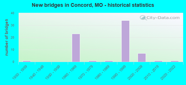
- New bridges - historical statistics
- 11930-1939
- 231960-1969
- 11970-1979
- 11980-1989
- 341990-1999
- 72000-2009
- 12010-2019
- 12020-2022
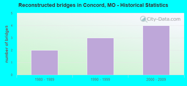
- Reconstructed bridges - Historical Statistics
- 21980-1989
- 31990-1999
- 42000-2009
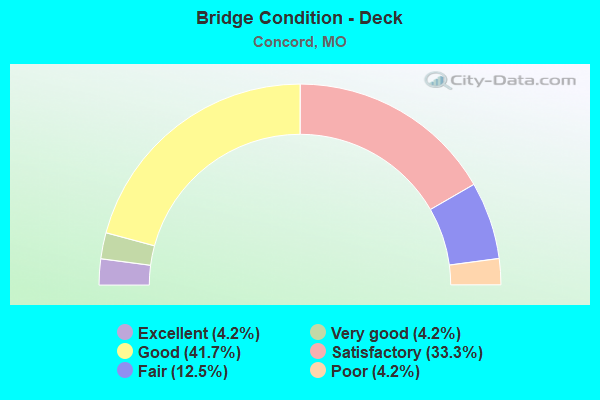
- Bridge Condition - Deck
- 4.2%Excellent
- 4.2%Very good
- 41.7%Good
- 33.3%Satisfactory
- 12.5%Fair
- 4.2%Poor
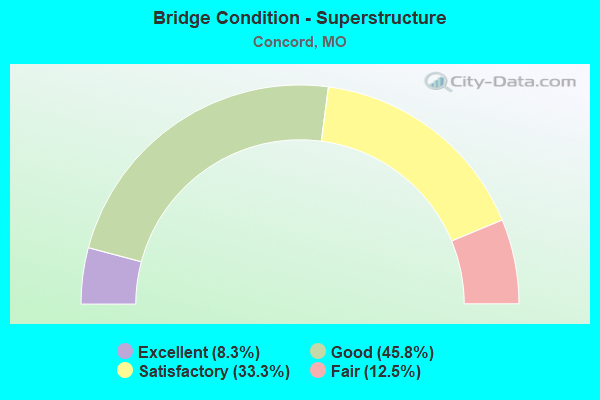
- Bridge Condition - Superstructure
- 8.3%Excellent
- 45.8%Good
- 33.3%Satisfactory
- 12.5%Fair
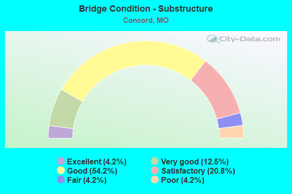
- Bridge Condition - Substructure
- 4.2%Excellent
- 12.5%Very good
- 54.2%Good
- 20.8%Satisfactory
- 4.2%Fair
- 4.2%Poor
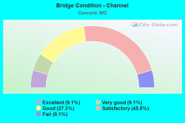
- Bridge Condition - Channel
- 9.1%Excellent
- 9.1%Very good
- 27.3%Good
- 45.5%Satisfactory
- 9.1%Fair
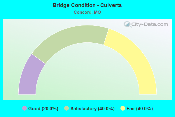
- Bridge Condition - Culverts
- 20.0%Good
- 40.0%Satisfactory
- 40.0%Fair
Find on map >> Show street view
Structure Number: 3975, Location: S 34 T 44 N R 6 E (Lat: 38.503317, Lng: -90.339017), Route carried "under" structure: Interstate 55, Year Built: 1991, Structure Length: 0. m, Average Daily Traffic: 62,732 (year 2021), Truck Traffic: 18%, Features Intersected: IS 55
Minimum Vertical Clearance: 13.29m (43.60ft), Kilometerpoint: 316.916, Lanes on structure: 2, Lanes under structure: 4, Material/Design: Steel continuous, Design/Construction: Stringer/Multi-beam, Length of Maximum Span: 27.5m (90.2ft)
Find on map >> Show street view
Structure Number: 3975, Location: S 34 T 44 N R 6 E (Lat: 38.503317, Lng: -90.339017), Route carried "under" structure: Interstate 55, Year Built: 1991, Structure Length: 0. m, Average Daily Traffic: 52,653 (year 2021), Truck Traffic: 18%, Features Intersected: IS 55
Minimum Vertical Clearance: 6.02m (19.75ft), Kilometerpoint: 20.741, Lanes on structure: 2, Lanes under structure: 4, Material/Design: Steel continuous, Design/Construction: Stringer/Multi-beam, Length of Maximum Span: 27.5m (90.2ft)
Find on map >> Show street view
Structure Number: 3975, Location: S 34 T 44 N R 6 E (Lat: 38.503317, Lng: -90.339017), Route carried "under" structure: Ramp State highway , Year Built: 1991, Structure Length: 0. m, Average Daily Traffic: 12,144 (year 2021), Truck Traffic: 18%, Features Intersected: RP IS270W TO IS55N, Facility Carried by Structure: RP IS55S TO IS255S
Minimum Vertical Clearance: 5.21m (17.09ft), Kilometerpoint: 1.553, Lanes on structure: 2, Lanes under structure: 1, Material/Design: Steel continuous, Design/Construction: Stringer/Multi-beam, Length of Maximum Span: 27.5m (90.2ft)
Find on map >> Show street view
Structure Number: 3975, Location: S 34 T 44 N R 6 E (Lat: 38.503317, Lng: -90.339017), Route carried "under" structure: Interstate 255, Year Built: 1991, Structure Length: 0. m, Average Daily Traffic: 44,129 (year 2021), Truck Traffic: 18%, Features Intersected: IS 255
Minimum Vertical Clearance: 5.15m (16.90ft), Kilometerpoint: 0.402, Lanes on structure: 2, Lanes under structure: 4, Material/Design: Steel continuous, Design/Construction: Stringer/Multi-beam, Length of Maximum Span: 27.5m (90.2ft)
Find on map >> Show street view
Structure Number: 3975, Location: S 34 T 44 N R 6 E (Lat: 38.503317, Lng: -90.339017), Route carried "under" structure: Ramp State highway , Year Built: 1991, Structure Length: 0. m, Average Daily Traffic: 12,988 (year 2021), Truck Traffic: 18%, Features Intersected: RP IS270W TO IS55N, Facility Carried by Structure: RP IS55S TO IS255S
Minimum Vertical Clearance: 5.21m (17.09ft), Kilometerpoint: 1.127, Lanes on structure: 2, Lanes under structure: 1, Material/Design: Steel continuous, Design/Construction: Stringer/Multi-beam, Length of Maximum Span: 27.5m (90.2ft)
Find on map >> Show street view
Structure Number: 3975, Location: S 34 T 44 N R 6 E (Lat: 38.503317, Lng: -90.339017), Route carried "under" structure: Ramp State highway , Year Built: 1991, Structure Length: 0. m, Average Daily Traffic: 9,516 (year 2021), Truck Traffic: 18%, Features Intersected: RP IS270E TO IS55S, Facility Carried by Structure: RP IS55S TO IS255S
Minimum Vertical Clearance: 5.21m (17.09ft), Kilometerpoint: 0.237, Lanes on structure: 2, Lanes under structure: 1, Material/Design: Steel continuous, Design/Construction: Stringer/Multi-beam, Length of Maximum Span: 27.5m (90.2ft)
Find on map >> Show street view
Structure Number: 3975, Location: S 34 T 44 N R 6 E (Lat: 38.503317, Lng: -90.339017), Route carried "under" structure: Ramp State highway , Year Built: 1991, Structure Length: 0. m, Average Daily Traffic: 12,988 (year 2021), Truck Traffic: 18%, Features Intersected: RP IS270W TO IS55N, Facility Carried by Structure: RP IS55S TO IS255S
Minimum Vertical Clearance: 4.95m (16.24ft), Kilometerpoint: 1.299, Lanes on structure: 2, Lanes under structure: 1, Material/Design: Steel continuous, Design/Construction: Stringer/Multi-beam, Length of Maximum Span: 27.5m (90.2ft)
Find on map >> Show street view
Structure Number: 3996, Location: S 4 T 43 N R 6 E (Lat: 38.495414, Lng: -90.346742), Route carried "under" structure: Interstate 55, Year Built: 1995, Structure Length: 0. m, Average Daily Traffic: 126,763 (year 2021), Truck Traffic: 18%, Features Intersected: IS 55, Facility Carried by Structure: MATTIS RD E
Minimum Vertical Clearance: 5.26m (17.26ft), Kilometerpoint: 315.812, Lanes on structure: 2, Lanes under structure: 6, Material/Design: Steel continuous, Design/Construction: Stringer/Multi-beam, Length of Maximum Span: 42.2m (138.5ft)
Find on map >> Show street view
Structure Number: 3996, Location: S 4 T 43 N R 6 E (Lat: 38.495414, Lng: -90.346742), Route carried "under" structure: Interstate 55, Year Built: 1995, Structure Length: 0. m, Average Daily Traffic: 126,763 (year 2021), Truck Traffic: 18%, Features Intersected: IS 55, Facility Carried by Structure: MATTIS RD E
Minimum Vertical Clearance: 5.49m (18.01ft), Kilometerpoint: 21.882, Lanes on structure: 2, Lanes under structure: 6, Material/Design: Steel continuous, Design/Construction: Stringer/Multi-beam, Length of Maximum Span: 42.2m (138.5ft)
Find on map >> Show street view
Structure Number: 4125, Location: S 34 T 44 N R 6 E (Lat: 38.511361, Lng: -90.335867), Route carried "under" structure: Interstate 55, Year Built: 1995, Structure Length: 0. m, Average Daily Traffic: 55,851 (year 2021), Truck Traffic: 18%, Features Intersected: IS 55, Facility Carried by Structure: US 50 E
Minimum Vertical Clearance: 5.31m (17.42ft), Kilometerpoint: 19.824, Lanes on structure: 7, Lanes under structure: 3, Material/Design: Prestressed concrete continuous, Design/Construction: Stringer/Multi-beam, Length of Maximum Span: 21.8m (71.5ft)
Find on map >> Show street view
Structure Number: 4125, Location: S 34 T 44 N R 6 E (Lat: 38.511361, Lng: -90.335867), Route carried "under" structure: Interstate 55, Year Built: 1995, Structure Length: 0. m, Average Daily Traffic: 49,189 (year 2021), Truck Traffic: 18%, Features Intersected: IS 55, Facility Carried by Structure: US 50 E
Minimum Vertical Clearance: 5.18m (16.99ft), Kilometerpoint: 317.865, Lanes on structure: 7, Lanes under structure: 4, Material/Design: Prestressed concrete continuous, Design/Construction: Stringer/Multi-beam, Length of Maximum Span: 21.8m (71.5ft)
Find on map >> Show street view
Structure Number: 419, Location: S 26 T 44 N R 6 E (Lat: 38.524708, Lng: -90.319728), Route carried "under" structure: City street , Year Built: 1962, Structure Length: 0. m, Average Daily Traffic: 4,510 (year 2021), Truck Traffic: 5%, Features Intersected: CST GREEN PARK RD, Facility Carried by Structure: IS 55 S
Minimum Vertical Clearance: 6.99m (22.93ft), Kilometerpoint: 2.667, Lanes on structure: 4, Lanes under structure: 2, Material/Design: Steel continuous, Design/Construction: Stringer/Multi-beam, Length of Maximum Span: 20.4m (66.9ft)
Find on map >> Show street view
Structure Number: 42, Location: S 26 T 44 N R 6 E (Lat: 38.524567, Lng: -90.319639), Route carried "under" structure: City street , Year Built: 1962, Structure Length: 0. m, Average Daily Traffic: 4,510 (year 2021), Truck Traffic: 5%, Features Intersected: CST GREEN PARK RD, Facility Carried by Structure: IS 55 N
Minimum Vertical Clearance: 6.99m (22.93ft), Kilometerpoint: 2.689, Lanes on structure: 4, Lanes under structure: 2, Material/Design: Steel continuous, Design/Construction: Stringer/Multi-beam, Length of Maximum Span: 20.4m (66.9ft)
Find on map >> Show street view
Structure Number: 832, Location: S 33 T 44 N R 6 E (Lat: 38.505239, Lng: -90.343917), Route carried "under" structure: County highway , Year Built: 1967, Structure Length: 0. m, Average Daily Traffic: 3,107 (year 2021), Truck Traffic: 5%, Features Intersected: CRD VON TALGE RD, Facility Carried by Structure: IS 270 E
Minimum Vertical Clearance: 10.49m (34.42ft), Kilometerpoint: 1.035, Lanes on structure: 7, Lanes under structure: 2, Material/Design: Steel continuous, Design/Construction: Stringer/Multi-beam, Length of Maximum Span: 25.6m (84.0ft)