Bridge Statistics for Eagan, Minnesota (MN)
Condition, Traffic, Stress, Structural Evaluation, Project Costs
- National Bridge Inventory (NBI) Statistics
- 69Number of bridges
- 1,759ft / 536mTotal length
- $3,270,999,000Total costs
- 2,511,252Total average daily traffic
- 90,057Total average daily truck traffic
- National Bridge Inventory (NBI) Registered Bridges for Eagan
- No street view available for this location
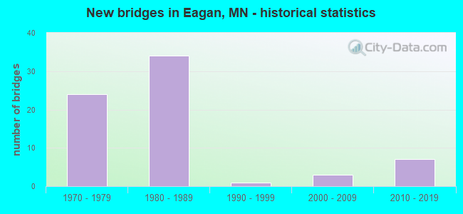
- New bridges - historical statistics
- 241970-1979
- 341980-1989
- 11990-1999
- 32000-2009
- 72010-2019
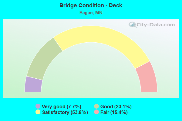
- Bridge Condition - Deck
- 7.7%Very good
- 23.1%Good
- 53.8%Satisfactory
- 15.4%Fair
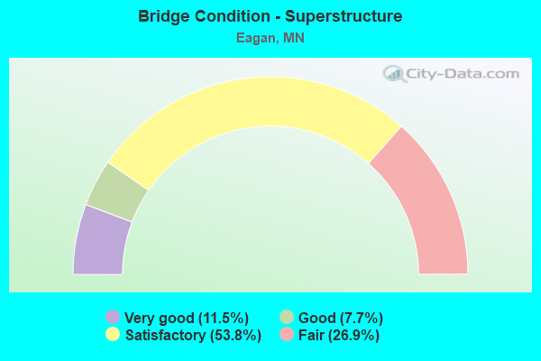
- Bridge Condition - Superstructure
- 11.5%Very good
- 7.7%Good
- 53.8%Satisfactory
- 26.9%Fair
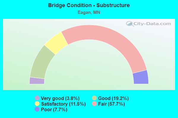
- Bridge Condition - Substructure
- 3.8%Very good
- 19.2%Good
- 11.5%Satisfactory
- 57.7%Fair
- 7.7%Poor
Find on map >> Show street view
Structure Number: 19864, Location: 2.3 MI SW OF JCT TH 494 (Lat: 44.833536, Lng: -93.163739), Route carried "under" structure: Interstate 35E, Year Built: 1984, Structure Length: 0. m, Average Daily Traffic: 86,233 (year 2019), Truck Traffic: 4%, Features Intersected: I 35E, NB ON RAMP, Facility Carried by Structure: CSAH 28
Minimum Vertical Clearance: 5.18m (16.99ft), Kilometerpoint: 0.000, Lanes on structure: 7, Lanes under structure: 8, Material/Design: Steel continuous, Design/Construction: Stringer/Multi-beam, Length of Maximum Span: 42.1m (138.1ft)
Find on map >> Show street view
Structure Number: 19864, Location: 2.3 MI SW OF JCT TH 494 (Lat: 44.833536, Lng: -93.163739), Route carried "under" structure: Ramp Interstate 3563, Year Built: 1984, Structure Length: 0. m, Average Daily Traffic: 8,900 (year 1996), Features Intersected: I 35E, NB ON RAMP, Facility Carried by Structure: CSAH 28
Minimum Vertical Clearance: 4.79m (15.72ft), Kilometerpoint: 0.000, Lanes on structure: 7, Lanes under structure: 2, Material/Design: Steel continuous, Design/Construction: Stringer/Multi-beam, Length of Maximum Span: 42.1m (138.1ft)
Find on map >> Show street view
Structure Number: 19882, Location: 1.5 MI NE OF JCT TH 77 (Lat: 44.794564, Lng: -93.198150), Route carried "under" structure: Interstate 35E, Year Built: 1983, Structure Length: 0. m, Average Daily Traffic: 81,000 (year 2019), Truck Traffic: 4%, Features Intersected: I 35E, Facility Carried by Structure: MSAS 103
Minimum Vertical Clearance: 5.27m (17.29ft), Kilometerpoint: 0.000, Lanes on structure: 2, Lanes under structure: 6, Material/Design: Steel continuous, Design/Construction: Stringer/Multi-beam, Length of Maximum Span: 42.1m (138.1ft)
Find on map >> Show street view
Structure Number: 19883, Location: 4.0 MI SW OF JCT TH 494 (Lat: 44.811150, Lng: -93.183914), Route carried "under" structure: Interstate 35E, Year Built: 1984, Structure Length: 0. m, Average Daily Traffic: 86,233 (year 2019), Truck Traffic: 4%, Features Intersected: I 35E, Facility Carried by Structure: MSAS 102
Minimum Vertical Clearance: 6.37m (20.90ft), Kilometerpoint: 0.000, Lanes on structure: 4, Lanes under structure: 6, Material/Design: Steel continuous, Design/Construction: Stringer/Multi-beam, Length of Maximum Span: 46.3m (151.9ft)