Bridge Statistics for El Monte, California (CA)
Condition, Traffic, Stress, Structural Evaluation, Project Costs
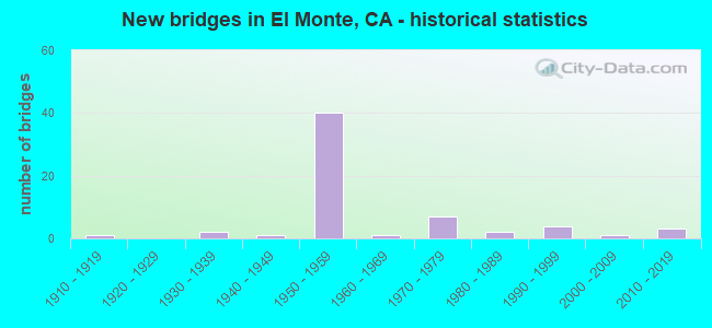
- New bridges - historical statistics
- 11910-1919
- 21930-1939
- 11940-1949
- 401950-1959
- 11960-1969
- 71970-1979
- 21980-1989
- 41990-1999
- 12000-2009
- 32010-2019
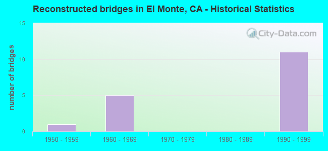
- Reconstructed bridges - Historical Statistics
- 11950-1959
- 51960-1969
- 01970-1979
- 01980-1989
- 111990-1999
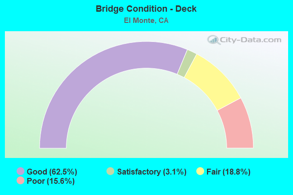
- Bridge Condition - Deck
- 62.5%Good
- 3.1%Satisfactory
- 18.8%Fair
- 15.6%Poor
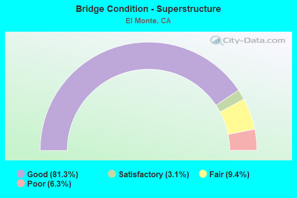
- Bridge Condition - Superstructure
- 81.3%Good
- 3.1%Satisfactory
- 9.4%Fair
- 6.3%Poor
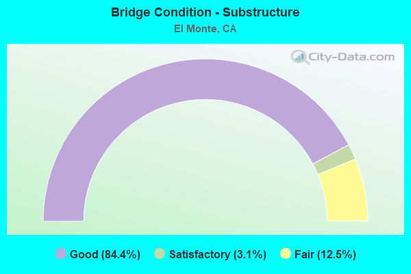
- Bridge Condition - Substructure
- 84.4%Good
- 3.1%Satisfactory
- 12.5%Fair
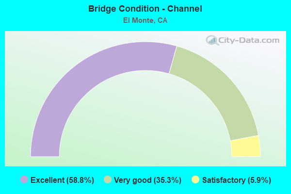
- Bridge Condition - Channel
- 58.8%Excellent
- 35.3%Very good
- 5.9%Satisfactory
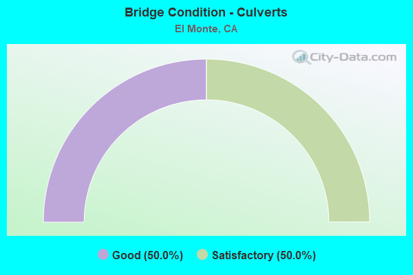
- Bridge Condition - Culverts
- 50.0%Good
- 50.0%Satisfactory
Find on map >> Show street view
Structure Number: 53 065, Location: 07-LA-010-24.32-ALH (Lat: 34.071347, Lng: -118.117264), Route carried "on" structure: City street , Year Built: 1953, Status: Open, Structure Length: 8.11m (26.61ft), Average Daily Traffic: 6,000 (year 2011), Truck Traffic: 1%, Average Future Daily Traffic: 9,493 (year 2040), Design Load: HS 20, Features Intersected: RTE 10, SCRRA, BNSF, HOV, Facility Carried by Structure: ALMANSOR AVE
Minimum Vertical Clearance: 30+ m (98+ ft), Kilometerpoint: 0.000, Lanes on structure: 2, Lanes under structure: 12, Owner: State Highway Agency, Approaching Roadway Width: 8.5m (27.9ft), Material/Design: Steel, Design/Construction: Stringer/Multi-beam, Number Of Spans In Main Unit: 5, Length of Maximum Span: 25.8m (84.6ft), Curb or Sidewalk Widths: Left: 1.8m (5.9ft), Right: 1.8m (5.9ft), Curb-To-Curb Width: 8.5m (27.9ft), Out-to-Out Width: 13.0m (42.7ft)
Condition: Deck: Good, Superstructure: Good, Substructure: Good, Operating Rating: 82.3 metric tons, Method Used To Determine Operating Rating: Load Factor (LF), Inventory Rating: 49.2 metric tons, Method Used To Determine Inventory Rating: Load Factor (LF), Structural Evaluation: Better than present minimum criteria, Deck Geometry: Meets minimum limits, Underclear: High priority of corrective action, Approach Roadway Alignment: Equal to present desirable criteria, Designated Inspection Frequency: Every 24 months, Critical Feature Inspection Frequency: Every 24 months, Inspection Date: December 2020, Critical Feature Inspection Date: December 2020, Deck Structure Type: Concrete Cast-file-Place
Find on map >> Show street view
Structure Number: 53 0656C, Location: 07-LA-010S-27.84-EMTE (Lat: 34.072514, Lng: -118.055608), Route carried "on" structure: Alternate Interstate 10, Year Built: 1972, Status: Open, Structure Length: 2.10m (6.89ft), Average Daily Traffic: 500 (year 2011), Truck Traffic: 1%, Average Future Daily Traffic: 618 (year 2036), Design Load: HS 20+Mod, Features Intersected: EATON WASH
Minimum Vertical Clearance: 30+ m (98+ ft), Kilometerpoint: 27.840, Lanes on structure: 1, Base Highway Network: Yes (, Subroute: 1), Owner: State Highway Agency, Approaching Roadway Width: 4.6m (15.1ft), Material/Design: Prestressed concrete, Design/Construction: Box Beam or Girders - Multiple, Number Of Spans In Main Unit: 1, Length of Maximum Span: 19.5m (64.0ft), Curb-To-Curb Width: 4.6m (15.1ft), Out-to-Out Width: 5.4m (17.7ft)
Condition: Deck: Good, Superstructure: Good, Substructure: Good, Channel: Very good, Operating Rating: 92.0 metric tons, Method Used To Determine Operating Rating: Load Factor (LF), Inventory Rating: 32.4 metric tons, Method Used To Determine Inventory Rating: Load Factor (LF), Structural Evaluation: Better than present minimum criteria, Deck Geometry: High priority of replacement, Waterway Adequacy: Superior to present desirable criteria, Approach Roadway Alignment: Equal to present desirable criteria, Designated Inspection Frequency: Every 48 months, Inspection Date: June 2019, Deck Structure Type: Concrete Cast-file-Place
Find on map >> Show street view
Structure Number: 53 0656L, Location: 07-LA-010-27.85-EMTE (Lat: 34.072547, Lng: -118.055733), Route carried "on" structure: Interstate 10, Year Built: 1956, Year Reconstructed: 1972, Status: Open, Structure Length: 1.92m (6.30ft), Average Daily Traffic: 105,500 (year 2009), Truck Traffic: 6%, Average Future Daily Traffic: 146,926 (year 2041), Design Load: HS 20, Features Intersected: EATON WASH
Minimum Vertical Clearance: 30+ m (98+ ft), Kilometerpoint: 27.850, Lanes on structure: 6, Base Highway Network: Yes (, Subroute: 1), Owner: State Highway Agency, Approaching Roadway Width: 35.8m (117.5ft), Material/Design: Concrete, Design/Construction: Box Beam or Girders - Multiple, Number Of Spans In Main Unit: 1, Length of Maximum Span: 19.2m (63.0ft), Curb or Sidewalk Widths: Left: 0.0m, Right: 0.6m (2.0ft), Curb-To-Curb Width: 35.8m (117.5ft), Out-to-Out Width: 36.7m (120.4ft)
Condition: Deck: Good, Superstructure: Good, Substructure: Good, Channel: Very good, Operating Rating: 68.4 metric tons, Method Used To Determine Operating Rating: Load Factor (LF), Inventory Rating: 32.4 metric tons, Method Used To Determine Inventory Rating: Load Factor (LF), Structural Evaluation: Better than present minimum criteria, Deck Geometry: Superior to present desirable criteria, Waterway Adequacy: Superior to present desirable criteria, Approach Roadway Alignment: Equal to present desirable criteria, Designated Inspection Frequency: Every 48 months, Inspection Date: Febuary 2019, Deck Structure Type: Concrete Cast-file-Place
Find on map >> Show street view
Structure Number: 53 0656R, Location: 07-LA-010-27.85-EMTE (Lat: 34.072167, Lng: -118.055725), Route carried "on" structure: Interstate 10, Year Built: 1956, Year Reconstructed: 1972, Status: Open, Structure Length: 1.89m (6.20ft), Average Daily Traffic: 105,500 (year 2009), Truck Traffic: 6%, Average Future Daily Traffic: 146,926 (year 2041), Design Load: HS 20, Features Intersected: EATON WASH
Minimum Vertical Clearance: 30+ m (98+ ft), Kilometerpoint: 27.850, Lanes on structure: 7, Base Highway Network: Yes (, Subroute: 1), Owner: State Highway Agency, Approaching Roadway Width: 28.9m (94.8ft), Material/Design: Concrete, Design/Construction: Box Beam or Girders - Multiple, Number Of Spans In Main Unit: 1, Length of Maximum Span: 18.9m (62.0ft), Curb-To-Curb Width: 28.9m (94.8ft), Out-to-Out Width: 29.6m (97.1ft)
Condition: Deck: Good, Superstructure: Good, Substructure: Good, Channel: Very good, Operating Rating: 67.4 metric tons, Method Used To Determine Operating Rating: Load Factor (LF), Inventory Rating: 32.4 metric tons, Method Used To Determine Inventory Rating: Load Factor (LF), Structural Evaluation: Better than present minimum criteria, Deck Geometry: Meets minimum limits, Waterway Adequacy: Superior to present desirable criteria, Approach Roadway Alignment: Superior to present desirable criteria, Designated Inspection Frequency: Every 48 months, Inspection Date: Febuary 2019, Deck Structure Type: Concrete Cast-file-Place
Find on map >> Show street view
Structure Number: 53 0657, Location: 07-LA-010-28.18-EMTE (Lat: 34.071394, Lng: -118.050686), Route carried "on" structure: Interstate 10, Year Built: 1956, Year Reconstructed: 2004, Status: Open, Structure Length: 14.30m (46.92ft), Average Daily Traffic: 227,000 (year 2011), Average Future Daily Traffic: 275,009 (year 2043), Design Load: HS 20, Features Intersected: RIO HONDO
Minimum Vertical Clearance: 30+ m (98+ ft), Kilometerpoint: 28.180, Lanes on structure: 13, Base Highway Network: Yes (, Subroute: 1), Owner: State Highway Agency, Approaching Roadway Width: 55.8m (183.1ft), Skew: 33 degrees, Material/Design: Concrete continuous, Design/Construction: Box Beam or Girders - Multiple, Number Of Spans In Main Unit: 6, Length of Maximum Span: 25.9m (85.0ft), Curb-To-Curb Width: 55.8m (183.1ft), Out-to-Out Width: 57.2m (187.7ft)
Condition: Deck: Fair, Superstructure: Good, Substructure: Good, Channel: Very good, Operating Rating: 71.6 metric tons, Method Used To Determine Operating Rating: Load Factor (LF), Inventory Rating: 43.5 metric tons, Method Used To Determine Inventory Rating: Load Factor (LF), Structural Evaluation: Better than present minimum criteria, Deck Geometry: Superior to present desirable criteria, Waterway Adequacy: Superior to present desirable criteria, Approach Roadway Alignment: Superior to present desirable criteria, Designated Inspection Frequency: Every 24 months, Inspection Date: Febuary 2021, Deck Structure Type: Concrete Cast-file-Place
Find on map >> Show street view
Structure Number: 53 0658, Location: 07-LA-010-28.67-EMTE (Lat: 34.068594, Lng: -118.042375), Route carried "on" structure: Interstate 10, Year Built: 1956, Year Reconstructed: 2004, Status: Open, Structure Length: 2.56m (8.40ft), Average Daily Traffic: 236,000 (year 2017), Truck Traffic: 4%, Average Future Daily Traffic: 273,185 (year 2043), Design Load: HS 20, Features Intersected: SANTA ANITA AVE
Minimum Vertical Clearance: 30+ m (98+ ft), Kilometerpoint: 28.670, Lanes on structure: 12, Lanes under structure: 6, Base Highway Network: Yes (, Subroute: 1), Owner: State Highway Agency, Approaching Roadway Width: 48.8m (160.1ft), Skew: 20 degrees, Material/Design: Concrete, Design/Construction: Box Beam or Girders - Multiple, Number Of Spans In Main Unit: 1, Length of Maximum Span: 25.0m (82.0ft), Curb-To-Curb Width: 48.8m (160.1ft), Out-to-Out Width: 50.3m (165.0ft)
Condition: Deck: Fair, Superstructure: Good, Substructure: Good, Operating Rating: 99.8 metric tons, Method Used To Determine Operating Rating: Load Factor (LF), Inventory Rating: 65.3 metric tons, Method Used To Determine Inventory Rating: Load Factor (LF), Structural Evaluation: Better than present minimum criteria, Deck Geometry: Somewhat better than minimum adequacy, Underclear: Meets minimum limits, Approach Roadway Alignment: Superior to present desirable criteria, Designated Inspection Frequency: Every 24 months, Inspection Date: March 2021, Deck Structure Type: Concrete Cast-file-Place
Find on map >> Show street view
Structure Number: 53 0659, Location: 07-LA-010-29.03-EMTE (Lat: 34.067842, Lng: -118.036158), Route carried "on" structure: Interstate 10, Year Built: 1956, Year Reconstructed: 2004, Status: Open, Structure Length: 3.18m (10.43ft), Average Daily Traffic: 233,000 (year 2017), Truck Traffic: 4%, Average Future Daily Traffic: 267,784 (year 2037), Design Load: HS 20, Features Intersected: TYLER AVE
Minimum Vertical Clearance: 30+ m (98+ ft), Kilometerpoint: 29.030, Lanes on structure: 14, Lanes under structure: 2, Base Highway Network: Yes (, Subroute: 1), Owner: State Highway Agency, Approaching Roadway Width: 57.5m (188.6ft), Skew: 20 degrees, Material/Design: Concrete continuous, Design/Construction: Box Beam or Girders - Multiple, Number Of Spans In Main Unit: 2, Length of Maximum Span: 15.5m (50.9ft), Curb-To-Curb Width: 57.5m (188.6ft), Out-to-Out Width: 59.3m (194.6ft)
Condition: Deck: Good, Superstructure: Good, Substructure: Good, Operating Rating: 66.2 metric tons, Method Used To Determine Operating Rating: Load Factor (LF), Inventory Rating: 40.8 metric tons, Method Used To Determine Inventory Rating: Load Factor (LF), Structural Evaluation: Better than present minimum criteria, Deck Geometry: Equal to present minimum criteria, Underclear: Equal to present minimum criteria, Approach Roadway Alignment: Equal to present desirable criteria, Designated Inspection Frequency: Every 48 months, Inspection Date: March 2019, Deck Structure Type: Concrete Cast-file-Place, Wearing Surface/Protective System: Wearing Surface: Monolithic Concrete
Find on map >> Show street view
Structure Number: 53 0661, Location: 07-LA-010-29.43-EMTE (Lat: 34.067742, Lng: -118.029433), Route carried "on" structure: Interstate 10, Year Built: 1956, Year Reconstructed: 2004, Status: Open, Structure Length: 4.24m (13.91ft), Average Daily Traffic: 219,000 (year 2009), Truck Traffic: 6%, Average Future Daily Traffic: 267,784 (year 2037), Design Load: HS 20, Features Intersected: PECK ROAD
Minimum Vertical Clearance: 30+ m (98+ ft), Kilometerpoint: 29.430, Lanes on structure: 15, Lanes under structure: 4, Base Highway Network: Yes (, Subroute: 1), Owner: State Highway Agency, Approaching Roadway Width: 59.7m (195.9ft), Skew: 34 degrees, Material/Design: Steel, Design/Construction: Stringer/Multi-beam, Number Of Spans In Main Unit: 2, Length of Maximum Span: 20.7m (67.9ft), Curb-To-Curb Width: 59.7m (195.9ft), Out-to-Out Width: 61.3m (201.1ft)
Condition: Deck: Good, Superstructure: Good, Substructure: Good, Operating Rating: 46.0 metric tons, Method Used To Determine Operating Rating: Load and Resistance Factor Rating (LRFR) rating reported by rating factor(RF) method using HL-93 loadings, Inventory Rating: 35.3 metric tons, Method Used To Determine Inventory Rating: Load and Resistance Factor Rating (LRFR) rating reported by rating factor(RF) method using HL-93 loadings, Structural Evaluation: Better than present minimum criteria, Deck Geometry: Meets minimum limits, Underclear: Somewhat better than minimum adequacy, Approach Roadway Alignment: Superior to present desirable criteria, Designated Inspection Frequency: Every 48 months, Other Special Inspection Frequency: Every 48 months, Inspection Date: March 2019, Other Special Inspection Date: September 2019, Deck Structure Type: Concrete Cast-file-Place
Find on map >> Show street view
Structure Number: 53 0662, Location: 07-LA-010-30.13-EMTE (Lat: 34.065847, Lng: -118.017606), Route carried "on" structure: Interstate 10, Year Built: 1956, Year Reconstructed: 2002, Status: Open, Structure Length: 1.96m (6.43ft), Average Daily Traffic: 213,000 (year 2017), Average Future Daily Traffic: 271,418 (year 2037), Design Load: HS 20, Features Intersected: COGSWELL RD
Minimum Vertical Clearance: 30+ m (98+ ft), Kilometerpoint: 30.130, Lanes on structure: 12, Lanes under structure: 2, Base Highway Network: Yes (, Subroute: 1), Owner: State Highway Agency, Approaching Roadway Width: 52.2m (171.3ft), Skew: 20 degrees, Material/Design: Concrete, Design/Construction: Box Beam or Girders - Multiple, Number Of Spans In Main Unit: 1, Length of Maximum Span: 18.9m (62.0ft), Curb-To-Curb Width: 52.2m (171.3ft), Out-to-Out Width: 54.0m (177.2ft)
Condition: Deck: Good, Superstructure: Good, Substructure: Good, Operating Rating: 82.5 metric tons, Method Used To Determine Operating Rating: Load Factor (LF), Inventory Rating: 49.9 metric tons, Method Used To Determine Inventory Rating: Load Factor (LF), Structural Evaluation: Better than present minimum criteria, Deck Geometry: Superior to present desirable criteria, Underclear: Equal to present minimum criteria, Approach Roadway Alignment: Equal to present desirable criteria, Designated Inspection Frequency: Every 48 months, Inspection Date: March 2019, Deck Structure Type: Concrete Cast-file-Place
Find on map >> Show street view
Structure Number: 53 0867, Location: 07-LA-010-29.81-EMTE (Lat: 34.067661, Lng: -118.022161), Route carried "on" structure: Interstate 10, Year Built: 1956, Year Reconstructed: 2002, Status: Open, Structure Length: 5.46m (17.91ft), Average Daily Traffic: 213,000 (year 2017), Average Future Daily Traffic: 276,892 (year 2043), Design Load: HS 20, Features Intersected: UP RR
Minimum Vertical Clearance: 30+ m (98+ ft), Kilometerpoint: 29.810, Lanes on structure: 12, Base Highway Network: Yes (, Subroute: 1), Owner: State Highway Agency, Approaching Roadway Width: 52.9m (173.6ft), Skew: 36 degrees, Material/Design: Steel, Design/Construction: Stringer/Multi-beam, Number Of Spans In Main Unit: 2, Length of Maximum Span: 26.8m (87.9ft), Curb or Sidewalk Widths: Left: 0.6m (2.0ft), Right: 0.6m (2.0ft), Curb-To-Curb Width: 52.9m (173.6ft), Out-to-Out Width: 54.0m (177.2ft)
Condition: Deck: Good, Superstructure: Good, Substructure: Good, Operating Rating: 35.6 metric tons, Method Used To Determine Operating Rating: Load and Resistance Factor Rating (LRFR) rating reported by rating factor(RF) method using HL-93 loadings, Inventory Rating: 27.5 metric tons, Method Used To Determine Inventory Rating: Load and Resistance Factor Rating (LRFR) rating reported by rating factor(RF) method using HL-93 loadings, Structural Evaluation: Equal to present minimum criteria, Deck Geometry: Superior to present desirable criteria, Underclear: Meets minimum limits, Approach Roadway Alignment: Equal to present desirable criteria, Designated Inspection Frequency: Every 24 months, Other Special Inspection Frequency: Every 48 months, Inspection Date: March 2021, Other Special Inspection Date: November 2021, Deck Structure Type: Concrete Cast-file-Place
Find on map >> Show street view
Structure Number: 53 0883, Location: 07-LA-010-28.84-EMTE (Lat: 34.068125, Lng: -118.039514), Route carried "on" structure: Interstate 10, Year Built: 1956, Year Reconstructed: 2004, Status: Open, Structure Length: 1.92m (6.30ft), Average Daily Traffic: 236,000 (year 2017), Truck Traffic: 4%, Average Future Daily Traffic: 267,784 (year 2037), Design Load: HS 20, Features Intersected: LEXINGTON AVE
Minimum Vertical Clearance: 30+ m (98+ ft), Kilometerpoint: 28.840, Lanes on structure: 14, Lanes under structure: 2, Base Highway Network: Yes (, Subroute: 1), Owner: State Highway Agency, Approaching Roadway Width: 65.9m (216.2ft), Skew: 20 degrees, Material/Design: Concrete, Design/Construction: Box Beam or Girders - Multiple, Number Of Spans In Main Unit: 1, Length of Maximum Span: 18.9m (62.0ft), Curb-To-Curb Width: 65.9m (216.2ft), Out-to-Out Width: 67.7m (222.1ft)
Condition: Deck: Good, Superstructure: Good, Substructure: Good, Operating Rating: 68.0 metric tons, Method Used To Determine Operating Rating: Load Factor (LF), Inventory Rating: 40.8 metric tons, Method Used To Determine Inventory Rating: Load Factor (LF), Structural Evaluation: Better than present minimum criteria, Deck Geometry: Superior to present desirable criteria, Underclear: Somewhat better than minimum adequacy, Approach Roadway Alignment: Superior to present desirable criteria, Designated Inspection Frequency: Every 48 months, Inspection Date: March 2019, Deck Structure Type: Concrete Cast-file-Place, Wearing Surface/Protective System: Wearing Surface: Monolithic Concrete
Find on map >> Show street view
Structure Number: 53 1021C, Location: 07-LA-010S-27.96-EMTE (Lat: 34.072511, Lng: -118.053608), Route carried "on" structure: Alternate Interstate 10, Year Built: 1956, Status: Open, Structure Length: 1.31m (4.30ft), Average Daily Traffic: 500 (year 2011), Truck Traffic: 40%, Average Future Daily Traffic: 629 (year 2038), Design Load: HS 20+Mod, Features Intersected: BALDWIN AVE
Minimum Vertical Clearance: 30+ m (98+ ft), Kilometerpoint: 27.960, Lanes on structure: 1, Lanes under structure: 2, Base Highway Network: Yes (, Subroute: 1), Owner: State Highway Agency, Approaching Roadway Width: 4.6m (15.1ft), Material/Design: Steel, Design/Construction: Stringer/Multi-beam, Number Of Spans In Main Unit: 1, Length of Maximum Span: 13.1m (43.0ft), Curb-To-Curb Width: 4.6m (15.1ft), Out-to-Out Width: 5.4m (17.7ft)
Condition: Deck: Good, Superstructure: Good, Substructure: Fair, Operating Rating: 95.9 metric tons, Method Used To Determine Operating Rating: Load and Resistance Factor Rating (LRFR) rating reported by rating factor(RF) method using HL-93 loadings, Inventory Rating: 74.2 metric tons, Method Used To Determine Inventory Rating: Load and Resistance Factor Rating (LRFR) rating reported by rating factor(RF) method using HL-93 loadings, Structural Evaluation: Somewhat better than minimum adequacy, Deck Geometry: High priority of replacement, Underclear: High priority of corrective action, Approach Roadway Alignment: Equal to present desirable criteria, Designated Inspection Frequency: Every 24 months, Inspection Date: October 2021, Deck Structure Type: Concrete Cast-file-Place
Find on map >> Show street view
Structure Number: 53 1021L, Location: 07-LA-010-27.96-EMTE (Lat: 34.072547, Lng: -118.053742), Route carried "on" structure: Interstate 10, Year Built: 1958, Year Reconstructed: 1972, Status: Open, Structure Length: 2.47m (8.10ft), Average Daily Traffic: 105,500 (year 2011), Truck Traffic: 6%, Average Future Daily Traffic: 146,926 (year 2041), Design Load: HS 20, Features Intersected: BALDWIN AVE
Minimum Vertical Clearance: 30+ m (98+ ft), Kilometerpoint: 27.960, Lanes on structure: 6, Lanes under structure: 2, Base Highway Network: Yes (, Subroute: 1), Owner: State Highway Agency, Approaching Roadway Width: 34.2m (112.2ft), Skew: 20 degrees, Material/Design: Concrete, Design/Construction: Tee Beam, Number Of Spans In Main Unit: 1, Length of Maximum Span: 23.5m (77.1ft), Curb or Sidewalk Widths: Left: 0.0m, Right: 0.6m (2.0ft), Curb-To-Curb Width: 34.2m (112.2ft), Out-to-Out Width: 35.1m (115.2ft)
Condition: Deck: Good, Superstructure: Good, Substructure: Fair, Operating Rating: 35.0 metric tons, Method Used To Determine Operating Rating: Load and Resistance Factor Rating (LRFR) rating reported by rating factor(RF) method using HL-93 loadings, Inventory Rating: 26.9 metric tons, Method Used To Determine Inventory Rating: Load and Resistance Factor Rating (LRFR) rating reported by rating factor(RF) method using HL-93 loadings, Structural Evaluation: Somewhat better than minimum adequacy, Deck Geometry: Superior to present desirable criteria, Underclear: High priority of corrective action, Approach Roadway Alignment: Equal to present desirable criteria, Designated Inspection Frequency: Every 24 months, Inspection Date: Febuary 2021, Deck Structure Type: Concrete Cast-file-Place
Find on map >> Show street view
Structure Number: 53 1021R, Location: 07-LA-010-27.96-EMTE (Lat: 34.072139, Lng: -118.053747), Route carried "on" structure: Interstate 10, Year Built: 1956, Year Reconstructed: 1972, Status: Open, Structure Length: 1.19m (3.90ft), Average Daily Traffic: 105,500 (year 2011), Truck Traffic: 6%, Average Future Daily Traffic: 146,926 (year 2041), Design Load: HS 20, Features Intersected: BALDWIN AVE
Minimum Vertical Clearance: 30+ m (98+ ft), Kilometerpoint: 27.960, Lanes on structure: 8, Lanes under structure: 2, Base Highway Network: Yes (, Subroute: 1), Owner: State Highway Agency, Approaching Roadway Width: 32.2m (105.6ft), Skew: 20 degrees, Material/Design: Concrete, Design/Construction: Slab, Number Of Spans In Main Unit: 1, Length of Maximum Span: 11.9m (39.0ft), Curb-To-Curb Width: 32.2m (105.6ft), Out-to-Out Width: 33.0m (108.3ft)
Condition: Deck: Good, Superstructure: Good, Substructure: Good, Operating Rating: 64.5 metric tons, Method Used To Determine Operating Rating: Load Factor (LF), Inventory Rating: 38.9 metric tons, Method Used To Determine Inventory Rating: Load Factor (LF), Structural Evaluation: Better than present minimum criteria, Deck Geometry: Meets minimum limits, Underclear: High priority of corrective action, Approach Roadway Alignment: Equal to present desirable criteria, Designated Inspection Frequency: Every 48 months, Inspection Date: Febuary 2021, Deck Structure Type: Concrete Cast-file-Place
Find on map >> Show street view
Structure Number: 53 1022L, Location: 07-LA-010S-28.01-EMTE (Lat: 34.072500, Lng: -118.052456), Route carried "on" structure: Interstate 10, Year Built: 1956, Year Reconstructed: 1972, Status: Open, Structure Length: 1.94m (6.36ft), Average Daily Traffic: 113,500 (year 2009), Truck Traffic: 6%, Average Future Daily Traffic: 133,892 (year 2036), Design Load: HS 20, Features Intersected: METROLINK, SCRTD BUSWAY
Minimum Vertical Clearance: 30+ m (98+ ft), Kilometerpoint: 28.010, Lanes on structure: 6, Lanes under structure: 2, Base Highway Network: Yes (, Subroute: 1), Owner: State Highway Agency, Approaching Roadway Width: 31.8m (104.3ft), Skew: 7 degrees, Material/Design: Concrete, Design/Construction: Slab, Number Of Spans In Main Unit: 2, Length of Maximum Span: 10.8m (35.4ft), Curb-To-Curb Width: 31.8m (104.3ft), Out-to-Out Width: 32.3m (106.0ft)
Condition: Deck: Good, Superstructure: Good, Substructure: Good, Operating Rating: 68.0 metric tons, Method Used To Determine Operating Rating: Load Factor (LF), Inventory Rating: 38.9 metric tons, Method Used To Determine Inventory Rating: Load Factor (LF), Structural Evaluation: Better than present minimum criteria, Deck Geometry: Superior to present desirable criteria, Underclear: Somewhat better than minimum adequacy, Approach Roadway Alignment: Equal to present desirable criteria, Designated Inspection Frequency: Every 48 months, Inspection Date: June 2019
Find on map >> Show street view
Structure Number: 53 1029, Location: 07-LA-010-29.34-EMTE (Lat: 34.067703, Lng: -118.030769), Route carried "on" structure: Interstate 10, Year Built: 1956, Year Reconstructed: 2004, Status: Open, Structure Length: 1.70m (5.58ft), Average Daily Traffic: 219,000 (year 2017), Truck Traffic: 4%, Average Future Daily Traffic: 273,185 (year 2043), Design Load: HS 20, Features Intersected: MEEKER RD
Minimum Vertical Clearance: 30+ m (98+ ft), Kilometerpoint: 29.340, Lanes on structure: 15, Lanes under structure: 2, Base Highway Network: Yes (, Subroute: 1), Owner: State Highway Agency, Approaching Roadway Width: 62.7m (205.7ft), Skew: 20 degrees, Material/Design: Concrete, Design/Construction: Box Beam or Girders - Multiple, Number Of Spans In Main Unit: 1, Length of Maximum Span: 16.2m (53.1ft), Curb-To-Curb Width: 62.7m (205.7ft), Out-to-Out Width: 64.3m (211.0ft)
Condition: Deck: Good, Superstructure: Fair, Substructure: Good, Operating Rating: 86.1 metric tons, Method Used To Determine Operating Rating: Load Factor (LF), Inventory Rating: 51.7 metric tons, Method Used To Determine Inventory Rating: Load Factor (LF), Structural Evaluation: Somewhat better than minimum adequacy, Deck Geometry: Better than present minimum criteria, Underclear: Meets minimum limits, Approach Roadway Alignment: Equal to present desirable criteria, Designated Inspection Frequency: Every 24 months, Inspection Date: March 2021, Deck Structure Type: Concrete Cast-file-Place
Find on map >> Show street view
Structure Number: 53 103, Location: 07-LA-010-29.90-EMTE (Lat: 34.067300, Lng: -118.020892), Route carried "on" structure: Interstate 10, Year Built: 1956, Year Reconstructed: 2002, Status: Open, Structure Length: 1.79m (5.87ft), Average Daily Traffic: 249,000 (year 2017), Truck Traffic: 5%, Average Future Daily Traffic: 307,452 (year 2043), Design Load: HS 20, Features Intersected: STEWART ST-E10 ON-RAMP
Minimum Vertical Clearance: 30+ m (98+ ft), Kilometerpoint: 29.900, Lanes on structure: 12, Lanes under structure: 1, Base Highway Network: Yes (, Subroute: 1), Owner: State Highway Agency, Approaching Roadway Width: 52.4m (171.9ft), Skew: 34 degrees, Material/Design: Concrete, Design/Construction: Frame, Number Of Spans In Main Unit: 1, Length of Maximum Span: 17.9m (58.7ft), Curb-To-Curb Width: 52.4m (171.9ft), Out-to-Out Width: 54.4m (178.5ft)
Condition: Deck: Good, Superstructure: Good, Substructure: Good, Operating Rating: 53.5 metric tons, Method Used To Determine Operating Rating: Load Factor (LF), Inventory Rating: 32.4 metric tons, Method Used To Determine Inventory Rating: Load Factor (LF), Structural Evaluation: Better than present minimum criteria, Deck Geometry: Superior to present desirable criteria, Underclear: High priority of corrective action, Approach Roadway Alignment: Equal to present desirable criteria, Designated Inspection Frequency: Every 24 months, Inspection Date: March 2021, Deck Structure Type: Concrete Cast-file-Place
Find on map >> Show street view
Structure Number: 53 1031, Location: 07-LA-010-30.51-EMTE (Lat: 34.064244, Lng: -118.011408), Route carried "on" structure: Interstate 10, Year Built: 1956, Year Reconstructed: 2004, Status: Open, Structure Length: 3.21m (10.53ft), Average Daily Traffic: 213,000 (year 2017), Average Future Daily Traffic: 276,892 (year 2043), Design Load: HS 20, Features Intersected: DURFEE RD
Minimum Vertical Clearance: 30+ m (98+ ft), Kilometerpoint: 30.510, Lanes on structure: 11, Lanes under structure: 4, Base Highway Network: Yes (, Subroute: 1), Owner: State Highway Agency, Approaching Roadway Width: 51.6m (169.3ft), Skew: 20 degrees, Material/Design: Concrete continuous, Design/Construction: Box Beam or Girders - Multiple, Number Of Spans In Main Unit: 2, Length of Maximum Span: 15.5m (50.9ft), Curb-To-Curb Width: 51.6m (169.3ft), Out-to-Out Width: 53.3m (174.9ft)
Condition: Deck: Good, Superstructure: Good, Substructure: Good, Operating Rating: 78.0 metric tons, Method Used To Determine Operating Rating: Load Factor (LF), Inventory Rating: 45.3 metric tons, Method Used To Determine Inventory Rating: Load Factor (LF), Structural Evaluation: Better than present minimum criteria, Deck Geometry: Superior to present desirable criteria, Underclear: Equal to present minimum criteria, Approach Roadway Alignment: Equal to present desirable criteria, Designated Inspection Frequency: Every 24 months, Inspection Date: March 2021, Deck Structure Type: Concrete Cast-file-Place, Wearing Surface/Protective System: Wearing Surface: Integral Concrete
Find on map >> Show street view
Structure Number: 53 1032, Location: 07-LA-010-30.58-EMTE (Lat: 34.064025, Lng: -118.010383), Route carried "on" structure: Interstate 10, Year Built: 1956, Year Reconstructed: 2002, Status: Open, Structure Length: 2.96m (9.71ft), Average Daily Traffic: 213,000 (year 2017), Average Future Daily Traffic: 271,418 (year 2041), Design Load: HS 20, Features Intersected: W10-GARVEY AVE OFF-RAMP
Minimum Vertical Clearance: 30+ m (98+ ft), Kilometerpoint: 30.580, Lanes on structure: 10, Lanes under structure: 2, Base Highway Network: Yes (, Subroute: 1), Owner: State Highway Agency, Approaching Roadway Width: 52.0m (170.6ft), Skew: 34 degrees, Material/Design: Concrete, Design/Construction: Box Beam or Girders - Multiple, Number Of Spans In Main Unit: 1, Length of Maximum Span: 17.1m (56.1ft), Curb-To-Curb Width: 52.0m (170.6ft), Out-to-Out Width: 53.5m (175.5ft)
Condition: Deck: Good, Superstructure: Good, Substructure: Good, Operating Rating: 84.3 metric tons, Method Used To Determine Operating Rating: Load Factor (LF), Inventory Rating: 49.9 metric tons, Method Used To Determine Inventory Rating: Load Factor (LF), Structural Evaluation: Better than present minimum criteria, Deck Geometry: Superior to present desirable criteria, Underclear: Meets minimum limits, Approach Roadway Alignment: Equal to present desirable criteria, Designated Inspection Frequency: Every 24 months, Inspection Date: March 2021, Deck Structure Type: Concrete Cast-file-Place
Find on map >> Show street view
Structure Number: 53 2636, Location: 07-LA-010S-28.32-EMTE (Lat: 34.072517, Lng: -118.047542), Route carried "on" structure: Ramp Interstate 10, Year Built: 1972, Status: Open, Structure Length: 1.01m (3.31ft), Average Daily Traffic: 200 (year 2011), Average Future Daily Traffic: 300 (year 2036), Design Load: HS 20, Features Intersected: LAFC ACCESS ROAD
Minimum Vertical Clearance: 30+ m (98+ ft), Kilometerpoint: 28.320, Lanes on structure: 2, Base Highway Network: Yes, Owner: State Highway Agency, Approaching Roadway Width: 15.8m (51.8ft), Skew: 16 degrees, Material/Design: Concrete, Design/Construction: Slab, Number Of Spans In Main Unit: 1, Length of Maximum Span: 10.1m (33.1ft), Curb-To-Curb Width: 15.8m (51.8ft), Out-to-Out Width: 16.6m (54.5ft)
Condition: Deck: Good, Superstructure: Good, Substructure: Good, Operating Rating: 99.8 metric tons, Method Used To Determine Operating Rating: Load Factor (LF), Inventory Rating: 58.0 metric tons, Method Used To Determine Inventory Rating: Load Factor (LF), Structural Evaluation: Better than present minimum criteria, Deck Geometry: Superior to present desirable criteria, Approach Roadway Alignment: Equal to present desirable criteria, Designated Inspection Frequency: Every 48 months, Inspection Date: June 2019, Deck Structure Type: Concrete Cast-file-Place, Wearing Surface/Protective System: Wearing Surface: Monolithic Concrete
Find on map >> Show street view
Structure Number: 53 2637, Location: 07-LA-010S-28.33-EMTE (Lat: 34.072519, Lng: -118.047350), Route carried "on" structure: Interstate 10, Year Built: 1972, Status: Open, Structure Length: 11.08m (36.35ft), Average Daily Traffic: 500 (year 2015), Truck Traffic: 5%, Average Future Daily Traffic: 618 (year 2040), Design Load: HS 20, Features Intersected: RIO HONDO RIVER
Minimum Vertical Clearance: 30+ m (98+ ft), Kilometerpoint: 28.330, Lanes on structure: 2, Base Highway Network: Yes (, Subroute: 1), Owner: State Highway Agency, Approaching Roadway Width: 13.6m (44.6ft), Skew: 5 degrees, Material/Design: Steel, Design/Construction: Stringer/Multi-beam, Number Of Spans In Main Unit: 3, Length of Maximum Span: 36.0m (118.1ft), Curb-To-Curb Width: 13.6m (44.6ft), Out-to-Out Width: 14.3m (46.9ft)
Condition: Deck: Poor, Superstructure: Good, Substructure: Good, Channel: Very good, Operating Rating: 28.5 metric tons, Method Used To Determine Operating Rating: Load and Resistance Factor Rating (LRFR) rating reported by rating factor(RF) method using HL-93 loadings, Inventory Rating: 22.0 metric tons, Method Used To Determine Inventory Rating: Load and Resistance Factor Rating (LRFR) rating reported by rating factor(RF) method using HL-93 loadings, Structural Evaluation: Somewhat better than minimum adequacy, Deck Geometry: Superior to present desirable criteria, Waterway Adequacy: Equal to present desirable criteria, Approach Roadway Alignment: Equal to present desirable criteria, Designated Inspection Frequency: Every 24 months, Critical Feature Inspection Frequency: Every 24 months, Other Special Inspection Frequency: Every 48 months, Inspection Date: October 2021, Critical Feature Inspection Date: March 2021, Other Special Inspection Date: March 2021, Deck Structure Type: Concrete Cast-file-Place, Wearing Surface/Protective System: Wearing Surface: Other
Find on map >> Show street view
Structure Number: 53C0126, Location: 0.2MI W/O BALDWIN AVE (Lat: 34.074222, Lng: -118.055764), Route carried "on" structure: City street , Year Built: 1955, Status: Open, Structure Length: 1.89m (6.20ft), Average Daily Traffic: 14,218 (year 2012), Truck Traffic: 2%, Average Future Daily Traffic: 16,351 (year 2041), Design Load: HS 20, Features Intersected: EATON WASH, Facility Carried by Structure: LOFTUS ST
Minimum Vertical Clearance: 30.47m (99.97ft), Kilometerpoint: 0.000, Lanes on structure: 4, Owner: City or Municipal Highway Agency, Approaching Roadway Width: 18.3m (60.0ft), Material/Design: Concrete, Design/Construction: Box Beam or Girders - Multiple, Number Of Spans In Main Unit: 1, Length of Maximum Span: 18.6m (61.0ft), Curb or Sidewalk Widths: Left: 1.6m (5.2ft), Right: 1.6m (5.2ft), Curb-To-Curb Width: 18.3m (60.0ft), Out-to-Out Width: 22.0m (72.2ft)
Condition: Deck: Fair, Superstructure: Good, Substructure: Good, Channel: Excellent, Operating Rating: 80.7 metric tons, Method Used To Determine Operating Rating: Load Factor (LF), Inventory Rating: 48.6 metric tons, Method Used To Determine Inventory Rating: Load Factor (LF), Structural Evaluation: Better than present minimum criteria, Deck Geometry: Somewhat better than minimum adequacy, Waterway Adequacy: Equal to present desirable criteria, Approach Roadway Alignment: Equal to present desirable criteria, Designated Inspection Frequency: Every 24 months, Inspection Date: March 2021, Deck Structure Type: Concrete Cast-file-Place, Wearing Surface/Protective System: Wearing Surface: Monolithic Concrete
Find on map >> Show street view
Structure Number: 53C034, Location: 0.5MI SE/O SAN ANTONIO DR (Lat: 33.905769, Lng: -118.069144), Route carried "on" structure: City street L164, Year Built: 1934, Year Reconstructed: 1950, Status: Open, Structure Length: 0.76m (2.49ft), Average Daily Traffic: 26,842 (year 2012), Truck Traffic: 1%, Average Future Daily Traffic: 32,211 (year 2040), Features Intersected: SILVERBOW STORM DRN, Facility Carried by Structure: FIRESTONE BLVD
Minimum Vertical Clearance: 30+ m (98+ ft), Kilometerpoint: 0.000, Lanes on structure: 5, Owner: City or Municipal Highway Agency, Approaching Roadway Width: 19.3m (63.3ft), Skew: 20 degrees, Material/Design: Concrete, Design/Construction: Culvert, Number Of Spans In Main Unit: 4, Length of Maximum Span: 1.8m (5.9ft), Curb or Sidewalk Widths: Left: 0.0m, Right: 3.7m (12.1ft), Curb-To-Curb Width: 22.3m (73.2ft), Out-to-Out Width: 27.7m (90.9ft)
Condition: Channel: Very good, Culverts: Good, Operating Rating: 40.5 metric tons, Method Used To Determine Operating Rating: Field evaluation and documented engineering judgment, Inventory Rating: 24.3 metric tons, Method Used To Determine Inventory Rating: Field evaluation and documented engineering judgment, Structural Evaluation: Equal to present minimum criteria, Deck Geometry: Equal to present minimum criteria, Waterway Adequacy: Equal to present desirable criteria, Approach Roadway Alignment: Equal to present desirable criteria, Designated Inspection Frequency: Every 48 months, Inspection Date: January 2021
Find on map >> Show street view
Structure Number: 53C0347, Location: 1.0MI E/O ROSEMEAD BLVD (Lat: 34.080186, Lng: -118.055839), Route carried "on" structure: City street L353, Year Built: 1956, Status: Open, Structure Length: 1.77m (5.81ft), Average Daily Traffic: 26,536 (year 2012), Truck Traffic: 4%, Average Future Daily Traffic: 31,843 (year 2041), Design Load: HS 20, Features Intersected: EATON WASH, Facility Carried by Structure: VALLEY BLVD
Minimum Vertical Clearance: 30.47m (99.97ft), Kilometerpoint: 0.000, Lanes on structure: 4, Owner: City or Municipal Highway Agency, Approaching Roadway Width: 23.5m (77.1ft), Skew: 2 degrees, Material/Design: Steel, Design/Construction: Stringer/Multi-beam, Number Of Spans In Main Unit: 1, Length of Maximum Span: 16.5m (54.1ft), Curb or Sidewalk Widths: Left: 2.2m (7.2ft), Right: 2.2m (7.2ft), Curb-To-Curb Width: 23.4m (76.8ft), Out-to-Out Width: 28.3m (92.8ft)
Condition: Deck: Poor, Superstructure: Good, Substructure: Fair, Channel: Excellent, Operating Rating: 76.5 metric tons, Method Used To Determine Operating Rating: Load Factor (LF), Inventory Rating: 45.7 metric tons, Method Used To Determine Inventory Rating: Load Factor (LF), Structural Evaluation: Somewhat better than minimum adequacy, Deck Geometry: Superior to present desirable criteria, Waterway Adequacy: Superior to present desirable criteria, Approach Roadway Alignment: Equal to present desirable criteria, Designated Inspection Frequency: Every 24 months, Inspection Date: March 2021, Deck Structure Type: Concrete Cast-file-Place, Wearing Surface/Protective System: Wearing Surface: Monolithic Concrete
Find on map >> Show street view
Structure Number: 53C0348, Location: 300FT W/O SANTA ANITA AVE (Lat: 34.076239, Lng: -118.042847), Route carried "on" structure: City street L353, Year Built: 1956, Status: Open, Structure Length: 7.41m (24.31ft), Average Daily Traffic: 21,186 (year 2012), Truck Traffic: 3%, Average Future Daily Traffic: 25,423 (year 2041), Design Load: HS 20, Features Intersected: RIO HONDO, Facility Carried by Structure: VALLEY BLVD
Minimum Vertical Clearance: 30.47m (99.97ft), Kilometerpoint: 0.000, Lanes on structure: 4, Owner: City or Municipal Highway Agency, Approaching Roadway Width: 23.2m (76.1ft), Skew: 3 degrees, Material/Design: Steel, Design/Construction: Stringer/Multi-beam, Number Of Spans In Main Unit: 3, Length of Maximum Span: 24.1m (79.1ft), Curb or Sidewalk Widths: Left: 2.2m (7.2ft), Right: 2.2m (7.2ft), Curb-To-Curb Width: 24.5m (80.4ft), Out-to-Out Width: 29.4m (96.5ft)
Condition: Deck: Fair, Superstructure: Fair, Substructure: Good, Channel: Excellent, Operating Rating: 58.3 metric tons, Method Used To Determine Operating Rating: Load Factor (LF), Inventory Rating: 35.0 metric tons, Method Used To Determine Inventory Rating: Load Factor (LF), Structural Evaluation: Somewhat better than minimum adequacy, Deck Geometry: Superior to present desirable criteria, Waterway Adequacy: Equal to present desirable criteria, Approach Roadway Alignment: Equal to present desirable criteria, Designated Inspection Frequency: Every 24 months, Inspection Date: March 2021, Deck Structure Type: Concrete Cast-file-Place
Find on map >> Show street view
Structure Number: 53C0421, Location: 0.2MI W/O ROSEMEAD BLVD (Lat: 34.029769, Lng: -118.071283), Route carried "on" structure: County highway L364, Year Built: 1982, Status: Open, Structure Length: 10.18m (33.40ft), Average Daily Traffic: 25,203 (year 2012), Truck Traffic: 2%, Average Future Daily Traffic: 30,243 (year 2040), Design Load: HS 20, Features Intersected: RIO HONDO, Facility Carried by Structure: SAN GABRIEL BLVD
Minimum Vertical Clearance: 30.47m (99.97ft), Kilometerpoint: 0.000, Lanes on structure: 4, Owner: County Highway Agency, Approaching Roadway Width: 22.6m (74.1ft), Skew: 39 degrees, Material/Design: Concrete continuous, Design/Construction: Slab, Number Of Spans In Main Unit: 10, Length of Maximum Span: 10.7m (35.1ft), Curb or Sidewalk Widths: Left: 1.6m (5.2ft), Right: 1.6m (5.2ft), Curb-To-Curb Width: 21.1m (69.2ft), Out-to-Out Width: 26.3m (86.3ft)
Condition: Deck: Satisfactory, Superstructure: Satisfactory, Substructure: Good, Channel: Excellent, Operating Rating: 73.9 metric tons, Method Used To Determine Operating Rating: Load Factor (LF), Inventory Rating: 44.4 metric tons, Method Used To Determine Inventory Rating: Load Factor (LF), Structural Evaluation: Equal to present minimum criteria, Deck Geometry: Superior to present desirable criteria, Waterway Adequacy: Superior to present desirable criteria, Approach Roadway Alignment: Equal to present desirable criteria, Designated Inspection Frequency: Every 48 months, Inspection Date: October 2020, Deck Structure Type: Concrete Cast-file-Place, Wearing Surface/Protective System: Wearing Surface: Monolithic Concrete
Find on map >> Show street view
Structure Number: 53C0434, Location: 0.4MI W/O SANTA ANITA AVE (Lat: 34.092711, Lng: -118.033392), Route carried "on" structure: City street L515, Year Built: 1959, Status: Open, Structure Length: 1.12m (3.67ft), Average Daily Traffic: 30,816 (year 2012), Truck Traffic: 3%, Average Future Daily Traffic: 36,979 (year 2041), Design Load: HS 20, Features Intersected: ARCADIA WASH, Facility Carried by Structure: LOWER AZUSA RD
Minimum Vertical Clearance: 30.47m (99.97ft), Kilometerpoint: 0.000, Lanes on structure: 4, Owner: City or Municipal Highway Agency, Approaching Roadway Width: 16.0m (52.5ft), Skew: 1 degrees, Material/Design: Concrete, Design/Construction: Slab, Number Of Spans In Main Unit: 1, Length of Maximum Span: 9.8m (32.2ft), Curb or Sidewalk Widths: Left: 1.6m (5.2ft), Right: 1.6m (5.2ft), Curb-To-Curb Width: 16.0m (52.5ft), Out-to-Out Width: 19.3m (63.3ft)
Condition: Deck: Poor, Superstructure: Poor, Substructure: Good, Channel: Excellent, Operating Rating: 57.7 metric tons, Method Used To Determine Operating Rating: Load Factor (LF), Inventory Rating: 34.7 metric tons, Method Used To Determine Inventory Rating: Load Factor (LF), Structural Evaluation: Meets minimum limits, Deck Geometry: Meets minimum limits, Waterway Adequacy: Superior to present desirable criteria, Approach Roadway Alignment: Equal to present desirable criteria, Designated Inspection Frequency: Every 24 months, Inspection Date: March 2021, Deck Structure Type: Concrete Cast-file-Place, Wearing Surface/Protective System: Wearing Surface: Monolithic Concrete
Find on map >> Show street view
Structure Number: 53C0435, Location: 1.0MI W/O PECK RD (Lat: 34.092533, Lng: -118.031539), Route carried "on" structure: City street L515, Year Built: 1959, Status: Open, Structure Length: 6.60m (21.65ft), Average Daily Traffic: 30,816 (year 2012), Truck Traffic: 2%, Average Future Daily Traffic: 36,979 (year 2041), Design Load: HS 20, Features Intersected: RIO HONDO, Facility Carried by Structure: LOWER AZUSA RD
Minimum Vertical Clearance: 30.47m (99.97ft), Kilometerpoint: 0.000, Lanes on structure: 4, Owner: City or Municipal Highway Agency, Approaching Roadway Width: 18.3m (60.0ft), Skew: 3 degrees, Material/Design: Concrete continuous, Design/Construction: Tee Beam, Number Of Spans In Main Unit: 3, Length of Maximum Span: 25.3m (83.0ft), Curb or Sidewalk Widths: Left: 1.6m (5.2ft), Right: 1.6m (5.2ft), Curb-To-Curb Width: 16.5m (54.1ft), Out-to-Out Width: 19.5m (64.0ft)
Condition: Deck: Fair, Superstructure: Good, Substructure: Satisfactory, Channel: Excellent, Operating Rating: 64.8 metric tons, Method Used To Determine Operating Rating: Load Factor (LF), Inventory Rating: 38.9 metric tons, Method Used To Determine Inventory Rating: Load Factor (LF), Structural Evaluation: Equal to present minimum criteria, Deck Geometry: Meets minimum limits, Waterway Adequacy: Superior to present desirable criteria, Approach Roadway Alignment: Equal to present desirable criteria, Designated Inspection Frequency: Every 24 months, Inspection Date: March 2021, Deck Structure Type: Concrete Cast-file-Place, Wearing Surface/Protective System: Wearing Surface: Monolithic Concrete
Find on map >> Show street view
Structure Number: 53C0648, Location: 0.8MI W/O PECK RD (Lat: 34.095042, Lng: -118.027597), Route carried "on" structure: City street L366, Year Built: 1959, Status: Open, Structure Length: 5.39m (17.68ft), Average Daily Traffic: 32,849 (year 2012), Truck Traffic: 2%, Average Future Daily Traffic: 39,419 (year 2041), Design Load: HS 20, Features Intersected: RIO HONDO, Facility Carried by Structure: SANTA ANITA AVE
Minimum Vertical Clearance: 30.47m (99.97ft), Kilometerpoint: 0.000, Lanes on structure: 4, Owner: City or Municipal Highway Agency, Approaching Roadway Width: 19.5m (64.0ft), Material/Design: Steel, Design/Construction: Stringer/Multi-beam, Number Of Spans In Main Unit: 3, Length of Maximum Span: 17.4m (57.1ft), Curb or Sidewalk Widths: Left: 1.6m (5.2ft), Right: 1.6m (5.2ft), Curb-To-Curb Width: 15.9m (52.2ft), Out-to-Out Width: 19.5m (64.0ft)
Condition: Deck: Poor, Superstructure: Fair, Substructure: Good, Channel: Excellent, Operating Rating: 36.0 metric tons, Method Used To Determine Operating Rating: Load Factor (LF), Inventory Rating: 21.7 metric tons, Method Used To Determine Inventory Rating: Load Factor (LF), Structural Evaluation: Somewhat better than minimum adequacy, Deck Geometry: Meets minimum limits, Waterway Adequacy: Superior to present desirable criteria, Approach Roadway Alignment: Equal to present desirable criteria, Designated Inspection Frequency: Every 24 months, Other Special Inspection Frequency: Every 48 months, Inspection Date: March 2021, Other Special Inspection Date: June 2019, Bridge Improvement Cost: $1,051,000, Roadway Improvement Cost: $494,000, Total Project Cost: $4,153,000 ( Estimate for 2017), Deck Structure Type: Concrete Cast-file-Place, Wearing Surface/Protective System: Wearing Surface: Monolithic Concrete
Find on map >> Show street view
Structure Number: 53C0890L, Location: 0.6MI S/O OCEAN BLVD (Lat: 33.755792, Lng: -118.200494), Route carried "on" structure: City street , Year Built: 1967, Status: Open, Structure Length: 13.38m (43.90ft), Average Daily Traffic: 1,020 (year 2012), Truck Traffic: 2%, Average Future Daily Traffic: 1,122 (year 2040), Design Load: HS 20, Features Intersected: HARBOR SCENIC DR, Facility Carried by Structure: QUEENS WAY-SBND
Minimum Vertical Clearance: 30.47m (99.97ft), Kilometerpoint: 0.000, Lanes on structure: 2, Lanes under structure: 6, Owner: City or Municipal Highway Agency, Approaching Roadway Width: 17.1m (56.1ft), Skew: 9 degrees, Material/Design: Concrete continuous, Design/Construction: Box Beam or Girders - Single/Spread, Number Of Spans In Main Unit: 5, Length of Maximum Span: 35.1m (115.2ft), Curb or Sidewalk Widths: Left: 0.6m (2.0ft), Right: 0.6m (2.0ft), Curb-To-Curb Width: 8.4m (27.6ft), Out-to-Out Width: 10.3m (33.8ft)
Condition: Deck: Good, Superstructure: Good, Substructure: Good, Operating Rating: 61.2 metric tons, Method Used To Determine Operating Rating: Load Factor (LF), Inventory Rating: 36.3 metric tons, Method Used To Determine Inventory Rating: Load Factor (LF), Structural Evaluation: Better than present minimum criteria, Deck Geometry: High priority of corrective action, Underclear: High priority of corrective action, Approach Roadway Alignment: Better than present minimum criteria, Designated Inspection Frequency: Every 24 months, Inspection Date: December 2020, Deck Structure Type: Concrete Cast-file-Place, Wearing Surface/Protective System: Wearing Surface: Bituminous
Find on map >> Show street view
Structure Number: 53C141, Location: 3.0MI E/O SAN GAB CYN RD (Lat: 34.231586, Lng: -117.792350), Route carried "on" structure: County highway W480, Year Built: 1942, Status: Open, Structure Length: 0.67m (2.20ft), Average Daily Traffic: 2,000 (year 2012), Truck Traffic: 1%, Average Future Daily Traffic: 2,200 (year 2039), Design Load: HS 20, Features Intersected: HORSE CYN CRK, Facility Carried by Structure: E FRK RD
Minimum Vertical Clearance: 30.47m (99.97ft), Kilometerpoint: 0.000, Lanes on structure: 2, Owner: County Highway Agency, Approaching Roadway Width: 7.3m (24.0ft), Skew: 3 degrees, Material/Design: Concrete, Design/Construction: Slab, Number Of Spans In Main Unit: 1, Length of Maximum Span: 6.0m (19.7ft), Curb or Sidewalk Widths: Left: 0.7m (2.3ft), Right: 0.7m (2.3ft), Curb-To-Curb Width: 7.3m (24.0ft), Out-to-Out Width: 9.0m (29.5ft)
Condition: Deck: Good, Superstructure: Good, Substructure: Good, Channel: Satisfactory, Operating Rating: 58.6 metric tons, Method Used To Determine Operating Rating: Load Factor (LF), Inventory Rating: 35.3 metric tons, Method Used To Determine Inventory Rating: Load Factor (LF), Structural Evaluation: Better than present minimum criteria, Deck Geometry: Meets minimum limits, Waterway Adequacy: Meets minimum limits, Approach Roadway Alignment: Better than present minimum criteria, Designated Inspection Frequency: Every 48 months, Inspection Date: October 2019, Deck Structure Type: Concrete Cast-file-Place, Wearing Surface/Protective System: Wearing Surface: Bituminous
Find on map >> Show street view
Structure Number: 53C1419, Location: 1.0MI E/O ROSEMEAD BLVD (Lat: 34.085272, Lng: -118.056625), Route carried "on" structure: City street L524, Year Built: 1956, Status: Open, Structure Length: 1.77m (5.81ft), Average Daily Traffic: 13,481 (year 2012), Truck Traffic: 4%, Average Future Daily Traffic: 15,503 (year 2041), Design Load: HS 20, Features Intersected: EATON WASH, Facility Carried by Structure: TEMPLE CITY BLVD
Minimum Vertical Clearance: 9.13m (29.95ft), Kilometerpoint: 0.000, Lanes on structure: 4, Owner: City or Municipal Highway Agency, Approaching Roadway Width: 17.1m (56.1ft), Skew: 2 degrees, Material/Design: Steel, Design/Construction: Stringer/Multi-beam, Number Of Spans In Main Unit: 1, Length of Maximum Span: 16.8m (55.1ft), Curb or Sidewalk Widths: Left: 1.6m (5.2ft), Right: 1.6m (5.2ft), Curb-To-Curb Width: 15.8m (51.8ft), Out-to-Out Width: 19.3m (63.3ft)
Condition: Deck: Poor, Superstructure: Poor, Substructure: Fair, Channel: Excellent, Operating Rating: 34.3 metric tons, Method Used To Determine Operating Rating: Load Factor (LF), Inventory Rating: 20.7 metric tons, Method Used To Determine Inventory Rating: Load Factor (LF), Structural Evaluation: Meets minimum limits, Deck Geometry: Meets minimum limits, Waterway Adequacy: Superior to present desirable criteria, Approach Roadway Alignment: Equal to present desirable criteria, Designated Inspection Frequency: Every 24 months, Inspection Date: March 2021, Bridge Improvement Cost: $341,000, Roadway Improvement Cost: $189,000, Total Project Cost: $1,591,000 ( Estimate for 2017), Deck Structure Type: Concrete Cast-file-Place, Wearing Surface/Protective System: Wearing Surface: Monolithic Concrete
Find on map >> Show street view
Structure Number: 53C164, Location: 50FT S/O LA CRESENTA AVE (Lat: 34.204953, Lng: -118.239750), Route carried "on" structure: City street , Year Built: 1979, Status: Open, Structure Length: 3.02m (9.91ft), Average Daily Traffic: 510 (year 2015), Truck Traffic: 1%, Average Future Daily Traffic: 561 (year 2041), Design Load: HS 20, Features Intersected: VERDUGO WASH, Facility Carried by Structure: OAKMONT VIEW DR
Minimum Vertical Clearance: 30+ m (98+ ft), Kilometerpoint: 0.000, Lanes on structure: 2, Owner: City or Municipal Highway Agency, Approaching Roadway Width: 8.5m (27.9ft), Material/Design: Prestressed concrete, Design/Construction: Stringer/Multi-beam, Number Of Spans In Main Unit: 1, Length of Maximum Span: 29.3m (96.1ft), Curb or Sidewalk Widths: Left: 1.5m (4.9ft), Right: 0.4m (1.3ft), Curb-To-Curb Width: 9.7m (31.8ft), Out-to-Out Width: 12.3m (40.4ft)
Condition: Deck: Fair, Superstructure: Good, Substructure: Good, Channel: Excellent, Operating Rating: 87.2 metric tons, Method Used To Determine Operating Rating: Load Factor (LF), Inventory Rating: 48.6 metric tons, Method Used To Determine Inventory Rating: Load Factor (LF), Structural Evaluation: Better than present minimum criteria, Deck Geometry: Equal to present minimum criteria, Waterway Adequacy: Superior to present desirable criteria, Approach Roadway Alignment: Equal to present minimum criteria, Designated Inspection Frequency: Every 24 months, Inspection Date: January 2022, Deck Structure Type: Concrete Cast-file-Place, Wearing Surface/Protective System: Wearing Surface: Monolithic Concrete
Find on map >> Show street view
Structure Number: 53C195, Location: AT AVE J (Lat: 34.689633, Lng: -118.174636), Route carried "on" structure: City street Q042, Year Built: 1991, Status: Open, Structure Length: 0.76m (2.49ft), Average Daily Traffic: 8,670 (year 2012), Truck Traffic: 4%, Average Future Daily Traffic: 9,971 (year 2038), Features Intersected: AMARGOSA DRN, Facility Carried by Structure: 25TH ST W
Minimum Vertical Clearance: 30+ m (98+ ft), Kilometerpoint: 0.000, Lanes on structure: 5, Owner: City or Municipal Highway Agency, Approaching Roadway Width: 21.3m (69.9ft), Skew: 20 degrees, Material/Design: Concrete, Design/Construction: Culvert, Number Of Spans In Main Unit: 2, Length of Maximum Span: 3.7m (12.1ft), Curb or Sidewalk Widths: Left: 2.2m (7.2ft), Right: 2.3m (7.5ft), Curb-To-Curb Width: 21.2m (69.6ft), Out-to-Out Width: 27.6m (90.6ft)
Condition: Channel: Excellent, Culverts: Satisfactory, Operating Rating: 54.1 metric tons, Method Used To Determine Operating Rating: Field evaluation and documented engineering judgment, Inventory Rating: 32.4 metric tons, Method Used To Determine Inventory Rating: Field evaluation and documented engineering judgment, Structural Evaluation: Equal to present minimum criteria, Deck Geometry: Somewhat better than minimum adequacy, Waterway Adequacy: Superior to present desirable criteria, Approach Roadway Alignment: Equal to present desirable criteria, Designated Inspection Frequency: Every 48 months, Inspection Date: May 2018
Find on map >> Show street view
Structure Number: 53 0658, Location: 07-LA-010-28.67-EMTE (Lat: 34.068594, Lng: -118.042375), Route carried "under" structure: City street , Year Built: 1956, Structure Length: 0. m, Average Daily Traffic: 39,900 (year 2011), Truck Traffic: 2%, Features Intersected: SANTA ANITA AVE, Facility Carried by Structure: INTERSTATE 10
Minimum Vertical Clearance: 4.55m (14.93ft), Kilometerpoint: 0.000, Lanes on structure: 12, Lanes under structure: 6, Material/Design: Concrete, Design/Construction: Box Beam or Girders - Multiple, Length of Maximum Span: 25.0m (82.0ft)
Find on map >> Show street view
Structure Number: 53 066, Location: 07-LA-010-29.55-EMTE (Lat: 34.067800, Lng: -118.026858), Route carried "under" structure: City street , Year Built: 1956, Structure Length: 0. m, Average Daily Traffic: 30,600 (year 2011), Truck Traffic: 2%, Features Intersected: VALLEY BOULEVARD, Facility Carried by Structure: INTERSTATE 10
Minimum Vertical Clearance: 4.60m (15.09ft), Kilometerpoint: 0.000, Lanes on structure: 15, Lanes under structure: 5, Material/Design: Steel, Design/Construction: Stringer/Multi-beam, Length of Maximum Span: 23.4m (76.8ft)
Find on map >> Show street view
Structure Number: 53 0661, Location: 07-LA-010-29.43-EMTE (Lat: 34.067742, Lng: -118.029433), Route carried "under" structure: City street , Year Built: 1956, Structure Length: 0. m, Average Daily Traffic: 3,800 (year 2011), Truck Traffic: 2%, Features Intersected: PECK ROAD, Facility Carried by Structure: INTERSTATE 10
Minimum Vertical Clearance: 4.65m (15.26ft), Kilometerpoint: 0.000, Lanes on structure: 15, Lanes under structure: 4, Material/Design: Steel, Design/Construction: Stringer/Multi-beam, Length of Maximum Span: 20.7m (67.9ft)
Find on map >> Show street view
Structure Number: 53 0662, Location: 07-LA-010-30.13-EMTE (Lat: 34.065847, Lng: -118.017606), Route carried "under" structure: City street , Year Built: 1956, Structure Length: 0. m, Average Daily Traffic: 11,600 (year 2017), Truck Traffic: 2%, Features Intersected: COGSWELL RD, Facility Carried by Structure: INTERSTATE 10
Minimum Vertical Clearance: 4.72m (15.49ft), Kilometerpoint: 0.000, Lanes on structure: 12, Lanes under structure: 2, Material/Design: Concrete, Design/Construction: Box Beam or Girders - Multiple, Length of Maximum Span: 18.9m (62.0ft)
Find on map >> Show street view
Structure Number: 53 0883, Location: 07-LA-010-28.84-EMTE (Lat: 34.068125, Lng: -118.039514), Route carried "under" structure: City street , Year Built: 1956, Structure Length: 0. m, Average Daily Traffic: 2,740 (year 2011), Truck Traffic: 2%, Features Intersected: LEXINGTON AVE, Facility Carried by Structure: I 10
Minimum Vertical Clearance: 4.52m (14.83ft), Kilometerpoint: 0.000, Lanes on structure: 14, Lanes under structure: 2, Material/Design: Concrete, Design/Construction: Box Beam or Girders - Multiple, Length of Maximum Span: 18.9m (62.0ft)
Find on map >> Show street view
Structure Number: 53 1021C, Location: 07-LA-010S-27.96-EMTE (Lat: 34.072511, Lng: -118.053608), Route carried "under" structure: City street , Year Built: 1956, Structure Length: 0. m, Average Daily Traffic: 16,300 (year 2011), Truck Traffic: 2%, Features Intersected: BALDWIN AVE, Facility Carried by Structure: W10 BUSWAY
Minimum Vertical Clearance: 4.52m (14.83ft), Kilometerpoint: 0.000, Lanes on structure: 1, Lanes under structure: 2, Material/Design: Steel, Design/Construction: Stringer/Multi-beam, Length of Maximum Span: 13.1m (43.0ft)
Find on map >> Show street view
Structure Number: 53 1021L, Location: 07-LA-010-27.96-EMTE (Lat: 34.072547, Lng: -118.053742), Route carried "under" structure: City street , Year Built: 1958, Structure Length: 0. m, Average Daily Traffic: 16,300 (year 2011), Truck Traffic: 2%, Features Intersected: BALDWIN AVE, Facility Carried by Structure: INTERSTATE 10 WB
Minimum Vertical Clearance: 5.74m (18.83ft), Kilometerpoint: 0.000, Lanes on structure: 6, Lanes under structure: 2, Material/Design: Concrete, Design/Construction: Tee Beam, Length of Maximum Span: 23.5m (77.1ft)
Find on map >> Show street view
Structure Number: 53 1021R, Location: 07-LA-010-27.96-EMTE (Lat: 34.072139, Lng: -118.053747), Route carried "under" structure: City street , Year Built: 1956, Structure Length: 0. m, Average Daily Traffic: 16,300 (year 2011), Truck Traffic: 2%, Features Intersected: BALDWIN AVE, Facility Carried by Structure: INTERSTATE 10 EB
Minimum Vertical Clearance: 4.62m (15.16ft), Kilometerpoint: 0.000, Lanes on structure: 8, Lanes under structure: 2, Material/Design: Concrete, Design/Construction: Slab, Length of Maximum Span: 11.9m (39.0ft)
Find on map >> Show street view
Structure Number: 53 1022L, Location: 07-LA-010S-28.01-EMTE (Lat: 34.072500, Lng: -118.052456), Route carried "under" structure: Alternate Interstate 10, Year Built: 1956, Structure Length: 0. m, Average Daily Traffic: 108,950 (year 2011), Truck Traffic: 6%, Features Intersected: METROLINK, SCRTD BUSWAY
Minimum Vertical Clearance: 4.80m (15.75ft), Kilometerpoint: 28.040, Lanes on structure: 6, Lanes under structure: 2, Material/Design: Concrete, Design/Construction: Slab, Length of Maximum Span: 10.8m (35.4ft)
Find on map >> Show street view
Structure Number: 53 1029, Location: 07-LA-010-29.34-EMTE (Lat: 34.067703, Lng: -118.030769), Route carried "under" structure: City street , Year Built: 1956, Structure Length: 0. m, Average Daily Traffic: 2,700 (year 2011), Truck Traffic: 5%, Features Intersected: MEEKER RD, Facility Carried by Structure: INTERSTATE 10
Minimum Vertical Clearance: 4.62m (15.16ft), Kilometerpoint: 0.000, Lanes on structure: 15, Lanes under structure: 2, Material/Design: Concrete, Design/Construction: Box Beam or Girders - Multiple, Length of Maximum Span: 16.2m (53.1ft)
Find on map >> Show street view
Structure Number: 53 103, Location: 07-LA-010-29.90-EMTE (Lat: 34.067300, Lng: -118.020892), Route carried "under" structure: Ramp Interstate 10, Year Built: 1956, Structure Length: 0. m, Average Daily Traffic: 234,700 (year 2017), Truck Traffic: 6%, Features Intersected: STEWART ST-E10 ON-RAMP
Minimum Vertical Clearance: 4.39m (14.40ft), Kilometerpoint: 29.900, Lanes on structure: 12, Lanes under structure: 1, Material/Design: Concrete, Design/Construction: Frame, Length of Maximum Span: 17.9m (58.7ft)
Find on map >> Show street view
Structure Number: 53 1031, Location: 07-LA-010-30.51-EMTE (Lat: 34.064244, Lng: -118.011408), Route carried "under" structure: City street , Year Built: 1956, Structure Length: 0. m, Average Daily Traffic: 12,000 (year 2017), Truck Traffic: 2%, Features Intersected: DURFEE RD, Facility Carried by Structure: INTERSTATE 10
Minimum Vertical Clearance: 4.62m (15.16ft), Kilometerpoint: 0.000, Lanes on structure: 11, Lanes under structure: 4, Material/Design: Concrete continuous, Design/Construction: Box Beam or Girders - Multiple, Length of Maximum Span: 15.5m (50.9ft)
Find on map >> Show street view
Structure Number: 53 1032, Location: 07-LA-010-30.58-EMTE (Lat: 34.064025, Lng: -118.010383), Route carried "under" structure: Ramp Interstate 10, Year Built: 1956, Structure Length: 0. m, Average Daily Traffic: 9,800 (year 2011), Truck Traffic: 2%, Features Intersected: W10-GARVEY AVE OFF-RAMP
Minimum Vertical Clearance: 4.57m (14.99ft), Kilometerpoint: 30.580, Lanes on structure: 10, Lanes under structure: 2, Material/Design: Concrete, Design/Construction: Box Beam or Girders - Multiple, Length of Maximum Span: 17.1m (56.1ft)
Find on map >> Show street view
Structure Number: 53 2635, Location: 07-LA-010S-28.26-EMTE (Lat: 34.072681, Lng: -118.048514), Route carried "under" structure: Interstate 10, Year Built: 1955, Structure Length: 0. m, Average Daily Traffic: 1,000 (year 2011), Truck Traffic: 5%, Features Intersected: W10 BUSWAY, Facility Carried by Structure: SCRRA METROLINK
Minimum Vertical Clearance: 4.57m (14.99ft), Kilometerpoint: 28.260, Lanes under structure: 1, Material/Design: Steel, Design/Construction: Girder and Floorbeam System, Length of Maximum Span: 32.3m (106.0ft)