Bridge Statistics for Escondido, California (CA)
Condition, Traffic, Stress, Structural Evaluation, Project Costs
- National Bridge Inventory (NBI) Statistics
- 155Number of bridges
- 1,814ft / 553mTotal length
- $4,750,000Total costs
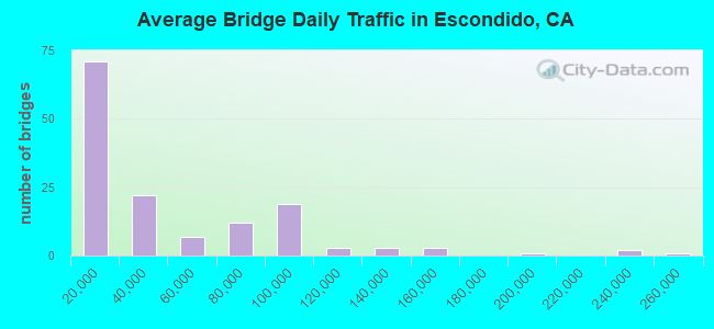
- 6,296,826Total average daily traffic
- 365,772Total average daily truck traffic
- 6,302,634Total future (year 2034) average daily traffic
- National Bridge Inventory (NBI) Registered Bridges for Escondido
- No street view available for this location
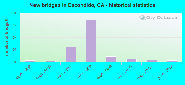
- New bridges - historical statistics
- 21900-1909
- 41940-1949
- 21950-1959
- 311960-1969
- 911970-1979
- 121980-1989
- 61990-1999
- 42000-2009
- 32010-2018
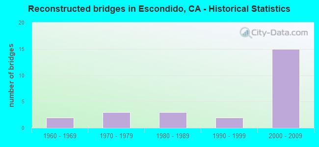
- Reconstructed bridges - Historical Statistics
- 21960-1969
- 41970-1979
- 31980-1989
- 21990-1999
- 162000-2009
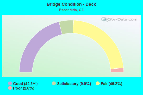
- Bridge Condition - Deck
- 25.6%Very good
- 39.5%Good
- 17.4%Satisfactory
- 16.3%Fair
- 1.2%Poor
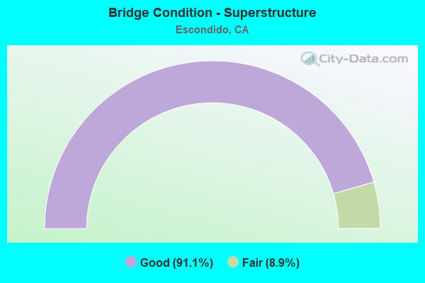
- Bridge Condition - Superstructure
- 34.5%Very good
- 60.9%Good
- 4.6%Satisfactory
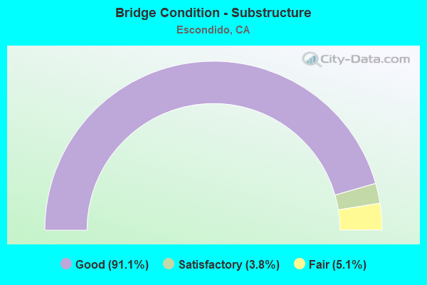
- Bridge Condition - Substructure
- 47.1%Very good
- 52.9%Good
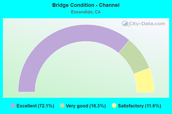
- Bridge Condition - Channel
- 69.4%Excellent
- 20.4%Very good
- 10.2%Satisfactory
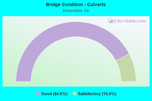
- Bridge Condition - Culverts
- 28.6%Very good
- 64.3%Good
- 7.1%Satisfactory
Find on map >> Show street view
Structure Number: 57C0782, Location: 1.1M N/O EL NORTE PKWY (Lat: 33.155197, Lng: -117.091856), Route carried "on" structure: City street , Year Built: 2006, Status: Open, Structure Length: 0.10m (0.33ft), Average Daily Traffic: 10,740 (year 2014), Truck Traffic: 2%, Average Future Daily Traffic: 11,000 (year 2034), Features Intersected: REIDY CREEK, Facility Carried by Structure: N. BROADWAY
Minimum Vertical Clearance: 30+ m (98+ ft), Kilometerpoint: 0.000, Lanes on structure: 5, Owner: City or Municipal Highway Agency, Approaching Roadway Width: 235.0m (771.0ft), Skew: 4 degrees, Material/Design: Concrete, Design/Construction: Culvert, Number Of Spans In Main Unit: 2, Length of Maximum Span: 0.2m (0.7ft), Curb or Sidewalk Widths: Left: 1.7m (5.6ft), Right: 2.8m (9.2ft)
Condition: Channel: Excellent, Culverts: Good, Operating Rating: 54.1 metric tons, Method Used To Determine Operating Rating: Field evaluation and documented engineering judgment, Inventory Rating: 32.4 metric tons, Method Used To Determine Inventory Rating: Field evaluation and documented engineering judgment, Structural Evaluation: Better than present minimum criteria, Waterway Adequacy: Meets minimum limits, Approach Roadway Alignment: Equal to present desirable criteria, Designated Inspection Frequency: Every 48 months, Inspection Date: March 2016
Find on map >> Show street view
Structure Number: 57C0783, Location: 1.05M N/O EL NORTE PKWY (Lat: 33.156831, Lng: -117.092117), Route carried "on" structure: City street , Year Built: 2006, Status: Open, Structure Length: 0.33m (1.08ft), Average Daily Traffic: 11,100 (year 2014), Truck Traffic: 2%, Average Future Daily Traffic: 12,500 (year 2034), Features Intersected: REIDY CREEK, Facility Carried by Structure: N. BROADWAY
Minimum Vertical Clearance: 30+ m (98+ ft), Kilometerpoint: 0.000, Lanes on structure: 5, Owner: City or Municipal Highway Agency, Approaching Roadway Width: 195.0m (639.8ft), Skew: 4 degrees, Material/Design: Concrete continuous, Design/Construction: Culvert, Number Of Spans In Main Unit: 6, Length of Maximum Span: 3.7m (12.1ft), Curb or Sidewalk Widths: Left: 1.7m (5.6ft), Right: 2.8m (9.2ft)
Condition: Channel: Very good, Culverts: Good, Operating Rating: 54.1 metric tons, Method Used To Determine Operating Rating: Field evaluation and documented engineering judgment, Inventory Rating: 32.4 metric tons, Method Used To Determine Inventory Rating: Field evaluation and documented engineering judgment, Structural Evaluation: Better than present minimum criteria, Waterway Adequacy: Meets minimum limits, Approach Roadway Alignment: Equal to present desirable criteria, Designated Inspection Frequency: Every 48 months, Inspection Date: March 2016
Find on map >> Show street view
Structure Number: 57C0784, Location: INT. OF JESMOND DENE RD (Lat: 33.168036, Lng: -117.090342), Route carried "on" structure: City street , Year Built: 2005, Status: Open, Structure Length: 1.18m (3.87ft), Average Daily Traffic: 11,100 (year 2014), Truck Traffic: 2%, Average Future Daily Traffic: 12,000 (year 2034), Features Intersected: REIDY CREEK, Facility Carried by Structure: N. BROADWAY
Minimum Vertical Clearance: 30+ m (98+ ft), Kilometerpoint: 0.000, Lanes on structure: 5, Owner: City or Municipal Highway Agency, Approaching Roadway Width: 195.0m (639.8ft), Skew: 4 degrees, Material/Design: Concrete, Design/Construction: Culvert, Number Of Spans In Main Unit: 1, Length of Maximum Span: 7.3m (24.0ft), Curb or Sidewalk Widths: Left: 1.8m (5.9ft), Right: 1.8m (5.9ft)
Condition: Channel: Excellent, Culverts: Satisfactory, Operating Rating: 54.1 metric tons, Method Used To Determine Operating Rating: Field evaluation and documented engineering judgment, Inventory Rating: 32.4 metric tons, Method Used To Determine Inventory Rating: Field evaluation and documented engineering judgment, Structural Evaluation: Equal to present minimum criteria, Waterway Adequacy: Equal to present minimum criteria, Approach Roadway Alignment: Equal to present desirable criteria, Designated Inspection Frequency: Every 48 months, Inspection Date: March 2016
Find on map >> Show street view
Structure Number: 57C0808M, Location: 0.24MI N/O FELICITA ROAD (Lat: 33.085256, Lng: -117.081683), Route carried "on" structure: County highway , Year Built: 2010, Status: Open, Structure Length: 0.82m (2.69ft), Average Daily Traffic: 350 (year 2016), Truck Traffic: 1%, Average Future Daily Traffic: 1,122 (year 2036), Features Intersected: SAN DIEGUITO R. TRIB., Facility Carried by Structure: MILLER AVENUE
Minimum Vertical Clearance: 30+ m (98+ ft), Kilometerpoint: 0.000, Lanes on structure: 2, Owner: County Highway Agency, Approaching Roadway Width: 106.0m (347.8ft), Material/Design: Concrete continuous, Design/Construction: Culvert, Number Of Spans In Main Unit: 4, Length of Maximum Span: 1.8m (5.9ft), Curb or Sidewalk Widths: Left: 0.0m, Right: 2.5m (8.2ft), Curb-To-Curb Width: 11.5m (37.7ft), Out-to-Out Width: 1.5m (4.9ft)
Condition: Channel: Excellent, Culverts: Good, Operating Rating: 54.1 metric tons, Method Used To Determine Operating Rating: Field evaluation and documented engineering judgment, Inventory Rating: 32.4 metric tons, Method Used To Determine Inventory Rating: Field evaluation and documented engineering judgment, Structural Evaluation: Better than present minimum criteria, Deck Geometry: Superior to present desirable criteria, Waterway Adequacy: Equal to present desirable criteria, Approach Roadway Alignment: Equal to present desirable criteria, Designated Inspection Frequency: Every 48 months, Inspection Date: June 2017