Bridge Statistics for Hannibal, Missouri (MO)
Condition, Traffic, Stress, Structural Evaluation, Project Costs
- National Bridge Inventory (NBI) Statistics
- 102Number of bridges
- 1,296ft / 395mTotal length
- $157,701,000Total costs
- 396,550Total average daily traffic
- 76,218Total average daily truck traffic
- National Bridge Inventory (NBI) Registered Bridges for Hannibal
- No street view available for this location
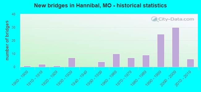
- New bridges - historical statistics
- 11900-1909
- 21910-1919
- 11920-1929
- 71930-1939
- 41950-1959
- 101960-1969
- 71970-1979
- 91980-1989
- 251990-1999
- 302000-2009
- 62010-2019
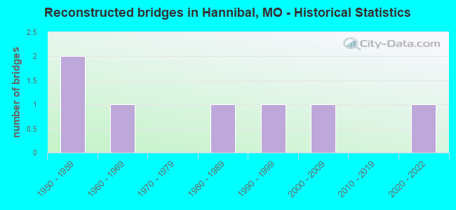
- Reconstructed bridges - Historical Statistics
- 21950-1959
- 11960-1969
- 01970-1979
- 11980-1989
- 11990-1999
- 12000-2009
- 02010-2019
- 12020-2022
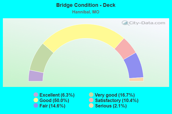
- Bridge Condition - Deck
- 6.3%Excellent
- 16.7%Very good
- 50.0%Good
- 10.4%Satisfactory
- 14.6%Fair
- 2.1%Serious
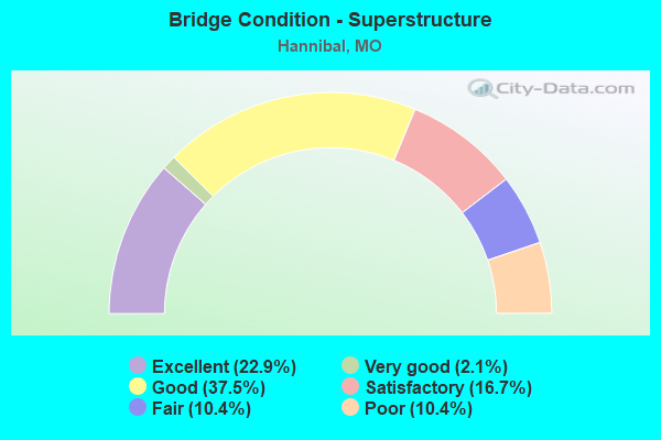
- Bridge Condition - Superstructure
- 22.9%Excellent
- 2.1%Very good
- 37.5%Good
- 16.7%Satisfactory
- 10.4%Fair
- 10.4%Poor
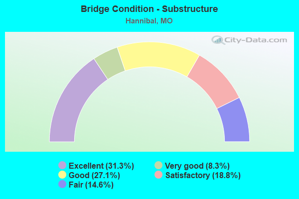
- Bridge Condition - Substructure
- 31.3%Excellent
- 8.3%Very good
- 27.1%Good
- 18.8%Satisfactory
- 14.6%Fair
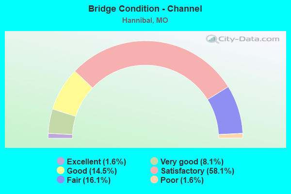
- Bridge Condition - Channel
- 1.6%Excellent
- 8.1%Very good
- 14.5%Good
- 58.1%Satisfactory
- 16.1%Fair
- 1.6%Poor
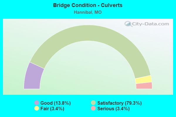
- Bridge Condition - Culverts
- 13.8%Good
- 79.3%Satisfactory
- 3.4%Fair
- 3.4%Serious
Find on map >> Show street view
Structure Number: 28929, Location: S 28 T 57 N R 5 W (Lat: 39.701594, Lng: -91.468411), Route carried "on" structure: US 36, Year Built: 2001, Status: Open, Structure Length: 4.38m (14.37ft), Average Daily Traffic: 4,966 (year 2021), Truck Traffic: 13%, Average Future Daily Traffic: 9,435 (year 2041), Design Load: HS 20+Mod, Features Intersected: BEAR CR
Minimum Vertical Clearance: 30+ m (98+ ft), Kilometerpoint: 10.063, Lanes on structure: 2, Base Highway Network: Yes, Owner: State Highway Agency, Approaching Roadway Width: 11.4m (37.4ft), Material/Design: Prestressed concrete continuous, Design/Construction: Stringer/Multi-beam, Number Of Spans In Main Unit: 3, Length of Maximum Span: 14.7m (48.2ft), Curb-To-Curb Width: 11.4m (37.4ft), Out-to-Out Width: 12.2m (40.0ft)
Condition: Deck: Good, Superstructure: Good, Substructure: Excellent, Channel: Satisfactory, Operating Rating: 82.8 metric tons, Method Used To Determine Operating Rating: Load Factor (LF), Inventory Rating: 36.0 metric tons, Method Used To Determine Inventory Rating: Load Factor (LF), Structural Evaluation: Better than present minimum criteria, Deck Geometry: Equal to present minimum criteria, Waterway Adequacy: Superior to present desirable criteria, Approach Roadway Alignment: Equal to present desirable criteria, Designated Inspection Frequency: Every 48 months, Inspection Date: October 2021, Deck Structure Type: Concrete Cast-file-Place, Wearing Surface/Protective System: Wearing Surface: Monolithic Concrete, Deck Protection: Epoxy Coated Reinforcing
Find on map >> Show street view
Structure Number: 29274, Location: S 32 T 57 N R 4 W (Lat: 39.689389, Lng: -91.375833), Route carried "on" structure: City street , Year Built: 2002, Status: Open, Structure Length: 1.28m (4.20ft), Average Daily Traffic: 2,500 (year 2021), Truck Traffic: 10%, Average Future Daily Traffic: 3,375 (year 2041), Design Load: HS 20, Features Intersected: MILLS CR, Facility Carried by Structure: JOHNSON ST
Minimum Vertical Clearance: 30+ m (98+ ft), Kilometerpoint: 0.000, Lanes on structure: 2, Owner: City or Municipal Highway Agency, Approaching Roadway Width: 7.3m (24.0ft), Material/Design: Concrete continuous, Design/Construction: Culvert, Number Of Spans In Main Unit: 3, Length of Maximum Span: 4.3m (14.1ft)
Condition: Channel: Satisfactory, Culverts: Satisfactory, Operating Rating: 57.6 metric tons, Method Used To Determine Operating Rating: Load Factor (LF), Inventory Rating: 34.2 metric tons, Method Used To Determine Inventory Rating: Load Factor (LF), Structural Evaluation: Equal to present minimum criteria, Waterway Adequacy: Equal to present minimum criteria, Approach Roadway Alignment: Equal to present desirable criteria, Designated Inspection Frequency: Every 24 months, Inspection Date: March 2021
Find on map >> Show street view
Structure Number: 29647, Location: S 26 T 58 N R 5 W (Lat: 39.787722, Lng: -91.420861), Route carried "on" structure: County highway 178, Year Built: 2003, Status: Open, Structure Length: 0.64m (2.10ft), Average Daily Traffic: 50 (year 2021), Truck Traffic: 10%, Average Future Daily Traffic: 63 (year 2041), Features Intersected: BRANCH, Facility Carried by Structure: COUNTY RD 411
Minimum Vertical Clearance: 30+ m (98+ ft), Kilometerpoint: 0.000, Lanes on structure: 2, Owner: County Highway Agency, Approaching Roadway Width: 6.1m (20.0ft), Material/Design: Steel continuous, Design/Construction: Culvert, Number Of Spans In Main Unit: 2, Length of Maximum Span: 3.0m (9.8ft)
Condition: Channel: Good, Culverts: Good, Structural Evaluation: Better than present minimum criteria, Waterway Adequacy: Equal to present minimum criteria, Approach Roadway Alignment: Equal to present desirable criteria, Designated Inspection Frequency: Every 24 months, Inspection Date: Febuary 2021
Find on map >> Show street view
Structure Number: 29678, Location: S 24 T 57 N R 5 W (Lat: 39.714439, Lng: -91.400550), Route carried "on" structure: US 36, Year Built: 2003, Status: Open, Structure Length: 3.96m (12.99ft), Average Daily Traffic: 5,453 (year 2021), Truck Traffic: 42%, Average Future Daily Traffic: 10,361 (year 2041), Design Load: HS 20+Mod, Features Intersected: CST MUNGER LN
Minimum Vertical Clearance: 30+ m (98+ ft), Kilometerpoint: 306.293, Lanes on structure: 2, Lanes under structure: 2, Base Highway Network: Yes, Owner: State Highway Agency, Approaching Roadway Width: 12.8m (42.0ft), Material/Design: Prestressed concrete continuous, Design/Construction: Stringer/Multi-beam, Number Of Spans In Main Unit: 3, Length of Maximum Span: 16.8m (55.1ft), Curb-To-Curb Width: 12.8m (42.0ft), Out-to-Out Width: 13.6m (44.6ft)
Condition: Deck: Very good, Superstructure: Good, Substructure: Excellent, Operating Rating: 77.4 metric tons, Method Used To Determine Operating Rating: Load Factor (LF), Inventory Rating: 45.9 metric tons, Method Used To Determine Inventory Rating: Load Factor (LF), Structural Evaluation: Better than present minimum criteria, Deck Geometry: Equal to present desirable criteria, Approach Roadway Alignment: Equal to present desirable criteria, Designated Inspection Frequency: Every 24 months, Inspection Date: October 2021, Deck Structure Type: Concrete Cast-file-Place, Wearing Surface/Protective System: Wearing Surface: Low Slump Concrete, Deck Protection: Epoxy Coated Reinforcing
Find on map >> Show street view
Structure Number: 29679, Location: S 24 T 57 N R 5 W (Lat: 39.714644, Lng: -91.400556), Route carried "on" structure: US 36, Year Built: 2003, Status: Open, Structure Length: 3.96m (12.99ft), Average Daily Traffic: 5,754 (year 2021), Truck Traffic: 30%, Average Future Daily Traffic: 10,933 (year 2041), Design Load: HS 20+Mod, Features Intersected: CST MUNGER LN
Minimum Vertical Clearance: 30+ m (98+ ft), Kilometerpoint: 3.722, Lanes on structure: 2, Lanes under structure: 2, Base Highway Network: Yes, Owner: State Highway Agency, Approaching Roadway Width: 12.8m (42.0ft), Material/Design: Prestressed concrete continuous, Design/Construction: Stringer/Multi-beam, Number Of Spans In Main Unit: 3, Length of Maximum Span: 16.8m (55.1ft), Curb-To-Curb Width: 12.8m (42.0ft), Out-to-Out Width: 13.6m (44.6ft)
Condition: Deck: Very good, Superstructure: Good, Substructure: Excellent, Operating Rating: 77.4 metric tons, Method Used To Determine Operating Rating: Load Factor (LF), Inventory Rating: 45.9 metric tons, Method Used To Determine Inventory Rating: Load Factor (LF), Structural Evaluation: Better than present minimum criteria, Deck Geometry: Equal to present desirable criteria, Underclear: Equal to present minimum criteria, Approach Roadway Alignment: Equal to present desirable criteria, Designated Inspection Frequency: Every 24 months, Inspection Date: October 2021, Deck Structure Type: Concrete Cast-file-Place, Wearing Surface/Protective System: Wearing Surface: Low Slump Concrete, Deck Protection: Epoxy Coated Reinforcing
Find on map >> Show street view
Structure Number: 30558, Location: S 11 T 57 N R 5 W (Lat: 39.752278, Lng: -91.427889), Route carried "on" structure: County highway 252, Year Built: 2004, Status: Open, Structure Length: 1.68m (5.51ft), Average Daily Traffic: 150 (year 2021), Truck Traffic: 10%, Average Future Daily Traffic: 188 (year 2041), Design Load: HS 20+Mod, Features Intersected: CLEAR CR, Facility Carried by Structure: COUNTY RD 409
Minimum Vertical Clearance: 30+ m (98+ ft), Kilometerpoint: 1.609, Lanes on structure: 2, Owner: County Highway Agency, Approaching Roadway Width: 6.1m (20.0ft), Material/Design: Concrete continuous, Design/Construction: Culvert, Number Of Spans In Main Unit: 3, Length of Maximum Span: 4.0m (13.1ft), Curb-To-Curb Width: 9.3m (30.5ft), Out-to-Out Width: 10.3m (33.8ft)
Condition: Channel: Satisfactory, Culverts: Satisfactory, Operating Rating: 72.0 metric tons, Method Used To Determine Operating Rating: Load Factor (LF), Inventory Rating: 43.2 metric tons, Method Used To Determine Inventory Rating: Load Factor (LF), Structural Evaluation: Equal to present minimum criteria, Deck Geometry: Equal to present minimum criteria, Waterway Adequacy: Better than present minimum criteria, Approach Roadway Alignment: Better than present minimum criteria, Designated Inspection Frequency: Every 24 months, Inspection Date: Febuary 2021, Deck Structure Type: Concrete Cast-file-Place, Wearing Surface/Protective System: Wearing Surface: Gravel
Find on map >> Show street view
Structure Number: 30875, Location: S 32 T 57 N R 4 W (Lat: 39.693722, Lng: -91.374278), Route carried "on" structure: City street 185, Year Built: 2006, Status: Open, Structure Length: 1.59m (5.22ft), Average Daily Traffic: 1,737 (year 2021), Truck Traffic: 10%, Average Future Daily Traffic: 2,345 (year 2041), Design Load: HS 20, Features Intersected: MILLS CR, Facility Carried by Structure: LINDELL AVE
Minimum Vertical Clearance: 30+ m (98+ ft), Kilometerpoint: 0.097, Lanes on structure: 2, Owner: City or Municipal Highway Agency, Approaching Roadway Width: 7.3m (24.0ft), Material/Design: Concrete continuous, Design/Construction: Slab, Number Of Spans In Main Unit: 3, Length of Maximum Span: 4.3m (14.1ft), Curb-To-Curb Width: 7.9m (25.9ft), Out-to-Out Width: 10.5m (34.4ft)
Condition: Deck: Good, Superstructure: Good, Substructure: Good, Channel: Good, Operating Rating: 60.3 metric tons, Method Used To Determine Operating Rating: Load Factor (LF), Inventory Rating: 36.0 metric tons, Method Used To Determine Inventory Rating: Load Factor (LF), Structural Evaluation: Better than present minimum criteria, Deck Geometry: Meets minimum limits, Waterway Adequacy: Equal to present minimum criteria, Approach Roadway Alignment: Equal to present desirable criteria, Designated Inspection Frequency: Every 24 months, Inspection Date: March 2021, Deck Structure Type: Concrete Cast-file-Place, Wearing Surface/Protective System: Deck Protection: Epoxy Coated Reinforcing
Find on map >> Show street view
Structure Number: 32413, Location: S 1 T 56 N R 5 W (Lat: 39.679689, Lng: -91.416461), Route carried "on" structure: City street , Year Built: 2008, Status: Open, Structure Length: 1.18m (3.87ft), Average Daily Traffic: 950 (year 2021), Truck Traffic: 50%, Average Future Daily Traffic: 1,283 (year 2041), Design Load: HS 20, Features Intersected: BRANCH, Facility Carried by Structure: RED DEVIL RD
Minimum Vertical Clearance: 30+ m (98+ ft), Kilometerpoint: 0.000, Lanes on structure: 2, Owner: City or Municipal Highway Agency, Approaching Roadway Width: 13.1m (43.0ft), Skew: 3 degrees, Material/Design: Concrete, Design/Construction: Culvert, Number Of Spans In Main Unit: 3, Length of Maximum Span: 3.0m (9.8ft), Curb-To-Curb Width: 13.1m (43.0ft), Out-to-Out Width: 14.1m (46.3ft)
Condition: Channel: Fair, Culverts: Satisfactory, Operating Rating: 54.0 metric tons, Method Used To Determine Operating Rating: Load Factor (LF), Inventory Rating: 32.4 metric tons, Method Used To Determine Inventory Rating: Load Factor (LF), Structural Evaluation: Equal to present minimum criteria, Deck Geometry: Superior to present desirable criteria, Waterway Adequacy: Equal to present minimum criteria, Approach Roadway Alignment: Equal to present desirable criteria, Designated Inspection Frequency: Every 24 months, Inspection Date: June 2020, Wearing Surface/Protective System: Wearing Surface: Monolithic Concrete
Find on map >> Show street view
Structure Number: 32701, Location: S 24 T 57 N R 4 W (Lat: 39.715861, Lng: -91.400694), Route carried "on" structure: City street , Year Built: 2009, Status: Posted for load, Structure Length: 0.68m (2.23ft), Average Daily Traffic: 2,730 (year 2021), Truck Traffic: 10%, Average Future Daily Traffic: 3,686 (year 2041), Design Load: HS 20, Features Intersected: MINNOW BR, Facility Carried by Structure: MUNGER LN
Minimum Vertical Clearance: 30+ m (98+ ft), Kilometerpoint: 0.000, Lanes on structure: 2, Owner: City or Municipal Highway Agency, Approaching Roadway Width: 6.1m (20.0ft), Material/Design: Concrete, Design/Construction: Culvert, Number Of Spans In Main Unit: 2, Length of Maximum Span: 3.0m (9.8ft), Curb-To-Curb Width: 11.2m (36.7ft), Out-to-Out Width: 12.2m (40.0ft)
Condition: Channel: Satisfactory, Culverts: Satisfactory, Operating Rating: 69.3 metric tons, Method Used To Determine Operating Rating: Load Factor (LF), Inventory Rating: 41.4 metric tons, Method Used To Determine Inventory Rating: Load Factor (LF), Structural Evaluation: Equal to present minimum criteria, Deck Geometry: Somewhat better than minimum adequacy, Waterway Adequacy: Better than present minimum criteria, Approach Roadway Alignment: Equal to present desirable criteria, Designated Inspection Frequency: Every 24 months, Inspection Date: March 2021, Wearing Surface/Protective System: Wearing Surface: Bituminous
Find on map >> Show street view
Structure Number: 33902, Location: S 28 T 57 N R 5 W (Lat: 39.700903, Lng: -91.466536), Route carried "on" structure: State highway MM, Year Built: 2012, Status: Open, Structure Length: 4.08m (13.39ft), Average Daily Traffic: 3,949 (year 2021), Truck Traffic: 5%, Average Future Daily Traffic: 5,726 (year 2041), Design Load: HS 20, Features Intersected: BEAR CR
Minimum Vertical Clearance: 30+ m (98+ ft), Kilometerpoint: 4.453, Lanes on structure: 2, Owner: State Highway Agency, Approaching Roadway Width: 8.5m (27.9ft), Skew: 1 degrees, Material/Design: Prestressed concrete, Design/Construction: Box Beam or Girders - Single/Spread, Number Of Spans In Main Unit: 3, Length of Maximum Span: 18.3m (60.0ft), Curb-To-Curb Width: 8.5m (27.9ft), Out-to-Out Width: 9.1m (29.9ft)
Condition: Deck: Good, Superstructure: Excellent, Substructure: Excellent, Channel: Satisfactory, Operating Rating: 87.3 metric tons, Method Used To Determine Operating Rating: Load Factor (LF), Inventory Rating: 52.2 metric tons, Method Used To Determine Inventory Rating: Load Factor (LF), Structural Evaluation: Superior to present desirable criteria, Deck Geometry: Meets minimum limits, Waterway Adequacy: Superior to present desirable criteria, Approach Roadway Alignment: Equal to present desirable criteria, Designated Inspection Frequency: Every 48 months, Inspection Date: October 2021, Deck Structure Type: Concrete Cast-file-Place, Wearing Surface/Protective System: Wearing Surface: Monolithic Concrete, Deck Protection: Epoxy Coated Reinforcing
Find on map >> Show street view
Structure Number: 34725, Location: S 19 T 56 N R 4 W (Lat: 39.634806, Lng: -91.387778), Route carried "on" structure: County highway 76, Year Built: 2014, Status: Open, Structure Length: 2.59m (8.50ft), Average Daily Traffic: 48 (year 2021), Truck Traffic: 10%, Average Future Daily Traffic: 60 (year 2041), Design Load: HS 20, Features Intersected: CAMP CR, Facility Carried by Structure: CAMP CREEK LN
Minimum Vertical Clearance: 30+ m (98+ ft), Kilometerpoint: 0.966, Lanes on structure: 2, Owner: County Highway Agency, Approaching Roadway Width: 8.5m (27.9ft), Skew: 2 degrees, Material/Design: Prestressed concrete, Design/Construction: Stringer/Multi-beam, Number Of Spans In Main Unit: 1, Length of Maximum Span: 25.1m (82.3ft), Curb or Sidewalk Widths: Left: 0.3m (1.0ft), Right: 0.3m (1.0ft), Curb-To-Curb Width: 7.3m (24.0ft), Out-to-Out Width: 8.0m (26.2ft)
Condition: Deck: Very good, Superstructure: Excellent, Substructure: Excellent, Channel: Satisfactory, Operating Rating: 56.7 metric tons, Method Used To Determine Operating Rating: Load Factor (LF), Inventory Rating: 34.2 metric tons, Method Used To Determine Inventory Rating: Load Factor (LF), Structural Evaluation: Superior to present desirable criteria, Deck Geometry: Equal to present minimum criteria, Waterway Adequacy: Superior to present desirable criteria, Approach Roadway Alignment: Equal to present minimum criteria, Designated Inspection Frequency: Every 24 months, Inspection Date: June 2020, Deck Structure Type: Concrete Precast Panels, Wearing Surface/Protective System: Wearing Surface: Monolithic Concrete
Find on map >> Show street view
Structure Number: 34937, Location: S 12 T 57 N R 5 W (Lat: 39.750994, Lng: -91.404475), Route carried "on" structure: State highway 168, Year Built: 2015, Status: Open, Structure Length: 5.29m (17.36ft), Average Daily Traffic: 2,549 (year 2021), Truck Traffic: 8%, Average Future Daily Traffic: 3,696 (year 2041), Features Intersected: CLEAR CR
Minimum Vertical Clearance: 30+ m (98+ ft), Kilometerpoint: 2.934, Lanes on structure: 2, Owner: State Highway Agency, Approaching Roadway Width: 8.5m (27.9ft), Skew: 1 degrees, Material/Design: Prestressed concrete continuous, Design/Construction: Tee Beam, Number Of Spans In Main Unit: 2, Length of Maximum Span: 26.5m (86.9ft), Curb-To-Curb Width: 8.5m (27.9ft), Out-to-Out Width: 9.3m (30.5ft)
Condition: Deck: Excellent, Superstructure: Excellent, Substructure: Excellent, Channel: Very good, Operating Rating: 70.2 metric tons, Method Used To Determine Operating Rating: Load Factor (LF), Inventory Rating: 34.2 metric tons, Method Used To Determine Inventory Rating: Load Factor (LF), Structural Evaluation: Superior to present desirable criteria, Deck Geometry: Meets minimum limits, Waterway Adequacy: Superior to present desirable criteria, Approach Roadway Alignment: Equal to present desirable criteria, Designated Inspection Frequency: Every 48 months, Inspection Date: October 2021, Deck Structure Type: Concrete Cast-file-Place, Wearing Surface/Protective System: Wearing Surface: Monolithic Concrete, Deck Protection: Epoxy Coated Reinforcing
Find on map >> Show street view
Structure Number: 35408, Location: S 29 T 57 N R 5 W (Lat: 39.709722, Lng: -91.480833), Route carried "on" structure: County highway 262, Year Built: 2017, Status: Open, Structure Length: 2.58m (8.46ft), Average Daily Traffic: 150 (year 2021), Truck Traffic: 10%, Average Future Daily Traffic: 188 (year 2041), Design Load: HS 20, Features Intersected: BEAR CR, Facility Carried by Structure: COUNTY RD 423
Minimum Vertical Clearance: 30+ m (98+ ft), Kilometerpoint: 0.483, Lanes on structure: 2, Owner: County Highway Agency, Approaching Roadway Width: 7.3m (24.0ft), Skew: 1 degrees, Material/Design: Prestressed concrete, Design/Construction: Box Beam or Girders - Multiple, Number Of Spans In Main Unit: 1, Length of Maximum Span: 25.0m (82.0ft), Curb or Sidewalk Widths: Left: 0.3m (1.0ft), Right: 0.3m (1.0ft), Curb-To-Curb Width: 7.6m (24.9ft), Out-to-Out Width: 8.2m (26.9ft)
Condition: Deck: Satisfactory, Superstructure: Satisfactory, Substructure: Excellent, Channel: Excellent, Operating Rating: 77.4 metric tons, Method Used To Determine Operating Rating: Load Factor (LF), Inventory Rating: 46.8 metric tons, Method Used To Determine Inventory Rating: Load Factor (LF), Structural Evaluation: Equal to present minimum criteria, Deck Geometry: Somewhat better than minimum adequacy, Waterway Adequacy: Superior to present desirable criteria, Approach Roadway Alignment: Equal to present desirable criteria, Designated Inspection Frequency: Every 24 months, Inspection Date: Febuary 2021, Deck Structure Type: Concrete Precast Panels, Wearing Surface/Protective System: Wearing Surface: Bituminous, Deck Protection: Epoxy Coated Reinforcing
Find on map >> Show street view
Structure Number: 35551, Location: S 28 T 57 N R 4 W (Lat: 39.702500, Lng: -91.357500), Route carried "on" structure: City street , Year Built: 2016, Status: Open, Structure Length: 2.44m (8.01ft), Average Daily Traffic: 70 (year 2021), Truck Traffic: 10%, Average Future Daily Traffic: 88 (year 2041), Design Load: HS 20, Features Intersected: BEAR CR, Facility Carried by Structure: ELY ST
Minimum Vertical Clearance: 30+ m (98+ ft), Kilometerpoint: 0.322, Lanes on structure: 2, Owner: City or Municipal Highway Agency, Approaching Roadway Width: 6.7m (22.0ft), Material/Design: Steel, Design/Construction: Truss - Deck, Number Of Spans In Main Unit: 1, Length of Maximum Span: 24.4m (80.1ft), Curb-To-Curb Width: 5.5m (18.0ft), Out-to-Out Width: 5.5m (18.0ft)
Condition: Deck: Excellent, Superstructure: Excellent, Substructure: Excellent, Channel: Very good, Operating Rating: 40.5 metric tons, Method Used To Determine Operating Rating: Load Factor (LF), Inventory Rating: 24.3 metric tons, Method Used To Determine Inventory Rating: Load Factor (LF), Structural Evaluation: Equal to present minimum criteria, Deck Geometry: Meets minimum limits, Waterway Adequacy: Superior to present desirable criteria, Approach Roadway Alignment: Equal to present minimum criteria, Designated Inspection Frequency: Every 24 months, Inspection Date: March 2021, Deck Structure Type: Other, Wearing Surface/Protective System: Wearing Surface: Epoxy Overlay, Membrane: Epoxy
Find on map >> Show street view
Structure Number: 35562, Location: S 1 T 56 N R 5 W (Lat: 39.678389, Lng: -91.409444), Route carried "on" structure: City street , Year Built: 2017, Status: Open, Structure Length: 3.96m (12.99ft), Average Daily Traffic: 4,103 (year 2021), Truck Traffic: 10%, Average Future Daily Traffic: 5,539 (year 2041), Features Intersected: BEAR CR, Facility Carried by Structure: WARREN BARRETT DR
Minimum Vertical Clearance: 30+ m (98+ ft), Kilometerpoint: 0.000, Lanes on structure: 2, Owner: City or Municipal Highway Agency, Approaching Roadway Width: 11.0m (36.1ft), Skew: 4 degrees, Material/Design: Prestressed concrete, Design/Construction: Box Beam or Girders - Single/Spread, Number Of Spans In Main Unit: 3, Length of Maximum Span: 19.8m (65.0ft), Curb-To-Curb Width: 11.0m (36.1ft), Out-to-Out Width: 11.6m (38.1ft)
Condition: Deck: Good, Superstructure: Excellent, Substructure: Good, Channel: Good, Operating Rating: 95.4 metric tons, Method Used To Determine Operating Rating: Load Factor (LF), Inventory Rating: 53.1 metric tons, Method Used To Determine Inventory Rating: Load Factor (LF), Structural Evaluation: Better than present minimum criteria, Deck Geometry: Somewhat better than minimum adequacy, Waterway Adequacy: Superior to present desirable criteria, Approach Roadway Alignment: Equal to present desirable criteria, Designated Inspection Frequency: Every 24 months, Inspection Date: June 2020, Deck Structure Type: Concrete Cast-file-Place
Find on map >> Show street view
Structure Number: 385, Location: S 1 T 56 N R 5 W (Lat: 39.679089, Lng: -91.411239), Route carried "on" structure: US 61, Year Built: 1990, Status: Open, Structure Length: 5.76m (18.90ft), Average Daily Traffic: 11,133 (year 2021), Truck Traffic: 23%, Average Future Daily Traffic: 21,153 (year 2041), Design Load: HS 20+Mod, Features Intersected: BEAR CR
Minimum Vertical Clearance: 30+ m (98+ ft), Kilometerpoint: 102.245, Lanes on structure: 3, Base Highway Network: Yes, Owner: State Highway Agency, Approaching Roadway Width: 14.0m (45.9ft), Material/Design: Prestressed concrete continuous, Design/Construction: Stringer/Multi-beam, Number Of Spans In Main Unit: 3, Length of Maximum Span: 23.8m (78.1ft), Curb or Sidewalk Widths: Left: 0.2m (0.7ft), Right: 0.2m (0.7ft), Curb-To-Curb Width: 15.5m (50.9ft), Out-to-Out Width: 16.3m (53.5ft)
Condition: Deck: Good, Superstructure: Good, Substructure: Good, Channel: Good, Operating Rating: 70.2 metric tons, Method Used To Determine Operating Rating: Load Factor (LF), Inventory Rating: 42.3 metric tons, Method Used To Determine Inventory Rating: Load Factor (LF), Structural Evaluation: Better than present minimum criteria, Deck Geometry: Somewhat better than minimum adequacy, Waterway Adequacy: Superior to present desirable criteria, Approach Roadway Alignment: Equal to present desirable criteria, Designated Inspection Frequency: Every 24 months, Inspection Date: November 2020, Deck Structure Type: Concrete Cast-file-Place, Wearing Surface/Protective System: Wearing Surface: Monolithic Concrete, Deck Protection: Internally Sealed
Find on map >> Show street view
Structure Number: 3851, Location: S 1 T 56 N R 5 W (Lat: 39.682708, Lng: -91.408233), Route carried "on" structure: US 61, Year Built: 1990, Status: Open, Structure Length: 7.71m (25.30ft), Average Daily Traffic: 11,133 (year 2021), Truck Traffic: 23%, Average Future Daily Traffic: 21,153 (year 2041), Design Load: HS 20+Mod, Features Intersected: NS RR
Minimum Vertical Clearance: 30+ m (98+ ft), Kilometerpoint: 101.757, Lanes on structure: 2, Base Highway Network: Yes, Owner: State Highway Agency, Approaching Roadway Width: 11.6m (38.1ft), Skew: 3 degrees, Material/Design: Prestressed concrete, Design/Construction: Stringer/Multi-beam, Number Of Spans In Main Unit: 5, Length of Maximum Span: 16.1m (52.8ft), Curb or Sidewalk Widths: Left: 0.2m (0.7ft), Right: 0.2m (0.7ft), Curb-To-Curb Width: 11.8m (38.7ft), Out-to-Out Width: 12.6m (41.3ft)
Condition: Deck: Good, Superstructure: Good, Substructure: Very good, Operating Rating: 69.3 metric tons, Method Used To Determine Operating Rating: Load Factor (LF), Inventory Rating: 42.3 metric tons, Method Used To Determine Inventory Rating: Load Factor (LF), Structural Evaluation: Better than present minimum criteria, Deck Geometry: Equal to present minimum criteria, Underclear: Better than present minimum criteria, Approach Roadway Alignment: Equal to present desirable criteria, Designated Inspection Frequency: Every 24 months, Inspection Date: November 2020, Deck Structure Type: Concrete Cast-file-Place, Wearing Surface/Protective System: Wearing Surface: Monolithic Concrete, Deck Protection: Internally Sealed
Find on map >> Show street view
Structure Number: 4076, Location: S 21 T 57 N R 4 W (Lat: 39.719167, Lng: -91.361300), Route carried "on" structure: Interstate 72, Year Built: 2000, Status: Open, Structure Length: 136.86m (449.02ft), Average Daily Traffic: 14,484 (year 2021), Truck Traffic: 33%, Average Future Daily Traffic: 27,520 (year 2041), Design Load: HS 20+Mod, Features Intersected: MISSISSIPPI RVR, CST 410
Minimum Vertical Clearance: 5.33m (17.49ft), Kilometerpoint: 2.675, Lanes on structure: 4, Lanes under structure: 4, Base Highway Network: Yes, Owner: State Highway Agency, Approaching Roadway Width: 26.1m (85.6ft), Skew: 33 degrees, Navigation Control: Yes ( Vertical Clearance: 18.9m (62.0ft), Horizontal Clearance: 182.9m (600.1ft)), Material/Design: Steel, Design/Construction: Truss - Thru, Number Of Spans In Main Unit: 1, Number Of Approach Spans: 25, Length of Maximum Span: 195.1m (640.1ft), Curb-To-Curb Width: 24.7m (81.0ft), Out-to-Out Width: 26.1m (85.6ft)
Condition: Deck: Good, Superstructure: Poor, Substructure: Good, Channel: Very good, Operating Rating: 54.0 metric tons, Method Used To Determine Operating Rating: Load Factor (LF), Inventory Rating: 22.5 metric tons, Method Used To Determine Inventory Rating: Load Factor (LF), Structural Evaluation: Meets minimum limits, Deck Geometry: Superior to present desirable criteria, Underclear: Superior to present desirable criteria, Waterway Adequacy: Equal to present desirable criteria, Approach Roadway Alignment: Equal to present desirable criteria, Length Of Structure Improvement: 13.69m (44.91ft), Designated Inspection Frequency: Every 24 months, Critical Feature Inspection Frequency: Every 24 months, Underwater Inspection Frequency: Every 60 months, Inspection Date: August 2021, Critical Feature Inspection Date: August 2021, Underwater Inspection Date: August 2021, Bridge Improvement Cost: $100,445,000, Roadway Improvement Cost: $10,044,000, Total Project Cost: $150,667,000 ( Estimate for 2022), Deck Structure Type: Concrete Cast-file-Place, Wearing Surface/Protective System: Wearing Surface: Monolithic Concrete, Deck Protection: Epoxy Coated Reinforcing
Find on map >> Show street view
Structure Number: 4144, Location: S 19 T 57 N R 4 W (Lat: 39.715492, Lng: -91.381528), Route carried "on" structure: Interstate 72, Year Built: 1993, Status: Open, Structure Length: 4.15m (13.62ft), Average Daily Traffic: 7,453 (year 2021), Truck Traffic: 23%, Average Future Daily Traffic: 14,161 (year 2041), Design Load: HS 20+Mod, Features Intersected: CST CENTRAL AVE
Minimum Vertical Clearance: 30+ m (98+ ft), Kilometerpoint: 2.079, Lanes on structure: 2, Lanes under structure: 2, Base Highway Network: Yes, Owner: State Highway Agency, Approaching Roadway Width: 12.5m (41.0ft), Skew: 2 degrees, Material/Design: Prestressed concrete continuous, Design/Construction: Stringer/Multi-beam, Number Of Spans In Main Unit: 3, Length of Maximum Span: 15.5m (50.9ft), Curb or Sidewalk Widths: Left: 0.2m (0.7ft), Right: 0.2m (0.7ft), Curb-To-Curb Width: 11.9m (39.0ft), Out-to-Out Width: 12.7m (41.7ft)
Condition: Deck: Good, Superstructure: Good, Substructure: Excellent, Operating Rating: 71.1 metric tons, Method Used To Determine Operating Rating: Load Factor (LF), Inventory Rating: 44.1 metric tons, Method Used To Determine Inventory Rating: Load Factor (LF), Structural Evaluation: Better than present minimum criteria, Deck Geometry: Equal to present minimum criteria, Underclear: Equal to present minimum criteria, Approach Roadway Alignment: Equal to present desirable criteria, Designated Inspection Frequency: Every 24 months, Inspection Date: October 2021, Deck Structure Type: Concrete Cast-file-Place, Wearing Surface/Protective System: Wearing Surface: Monolithic Concrete, Deck Protection: Internally Sealed
Find on map >> Show street view
Structure Number: 4156, Location: S 19 T 57 N R 4 W (Lat: 39.715378, Lng: -91.381558), Route carried "on" structure: Interstate 72, Year Built: 1993, Status: Open, Structure Length: 4.15m (13.62ft), Average Daily Traffic: 7,319 (year 2021), Truck Traffic: 26%, Average Future Daily Traffic: 13,906 (year 2041), Design Load: HS 20+Mod, Features Intersected: CST CENTRAL AVE
Minimum Vertical Clearance: 30+ m (98+ ft), Kilometerpoint: 1.180, Lanes on structure: 2, Lanes under structure: 2, Base Highway Network: Yes, Owner: State Highway Agency, Approaching Roadway Width: 12.5m (41.0ft), Skew: 2 degrees, Material/Design: Prestressed concrete continuous, Design/Construction: Stringer/Multi-beam, Number Of Spans In Main Unit: 3, Length of Maximum Span: 15.5m (50.9ft), Curb or Sidewalk Widths: Left: 0.2m (0.7ft), Right: 0.2m (0.7ft), Curb-To-Curb Width: 11.9m (39.0ft), Out-to-Out Width: 12.7m (41.7ft)
Condition: Deck: Good, Superstructure: Good, Substructure: Excellent, Operating Rating: 68.4 metric tons, Method Used To Determine Operating Rating: Load Factor (LF), Inventory Rating: 40.5 metric tons, Method Used To Determine Inventory Rating: Load Factor (LF), Structural Evaluation: Better than present minimum criteria, Deck Geometry: Equal to present minimum criteria, Underclear: Equal to present minimum criteria, Approach Roadway Alignment: Equal to present desirable criteria, Designated Inspection Frequency: Every 24 months, Inspection Date: October 2021, Deck Structure Type: Concrete Cast-file-Place, Wearing Surface/Protective System: Wearing Surface: Monolithic Concrete, Deck Protection: Epoxy Coated Reinforcing
Find on map >> Show street view
Structure Number: 4283, Location: S 192 T 57 N R 4 W (Lat: 39.717064, Lng: -91.372831), Route carried "on" structure: Interstate 72, Year Built: 1997, Status: Open, Structure Length: 6.19m (20.31ft), Average Daily Traffic: 7,319 (year 2021), Truck Traffic: 26%, Average Future Daily Traffic: 13,906 (year 2041), Design Load: HS 25 or greater, Features Intersected: MO 79
Minimum Vertical Clearance: 30+ m (98+ ft), Kilometerpoint: 1.939, Lanes on structure: 2, Lanes under structure: 2, Base Highway Network: Yes, Owner: State Highway Agency, Approaching Roadway Width: 12.5m (41.0ft), Skew: 11 degrees, Material/Design: Prestressed concrete continuous, Design/Construction: Stringer/Multi-beam, Number Of Spans In Main Unit: 3, Length of Maximum Span: 28.3m (92.8ft), Curb or Sidewalk Widths: Left: 0.4m (1.3ft), Right: 0.4m (1.3ft), Curb-To-Curb Width: 11.9m (39.0ft), Out-to-Out Width: 12.7m (41.7ft)
Condition: Deck: Very good, Superstructure: Excellent, Substructure: Excellent, Operating Rating: 84.6 metric tons, Method Used To Determine Operating Rating: Load Factor (LF), Inventory Rating: 50.4 metric tons, Method Used To Determine Inventory Rating: Load Factor (LF), Structural Evaluation: Superior to present desirable criteria, Deck Geometry: Equal to present minimum criteria, Underclear: Equal to present minimum criteria, Approach Roadway Alignment: Equal to present desirable criteria, Designated Inspection Frequency: Every 24 months, Inspection Date: October 2021, Deck Structure Type: Concrete Cast-file-Place, Wearing Surface/Protective System: Wearing Surface: Monolithic Concrete, Deck Protection: Epoxy Coated Reinforcing
Find on map >> Show street view
Structure Number: 4284, Location: S 192 T 57 N R 4 W (Lat: 39.717161, Lng: -91.372908), Route carried "on" structure: Interstate 72, Year Built: 1997, Status: Open, Structure Length: 6.19m (20.31ft), Average Daily Traffic: 6,916 (year 2021), Truck Traffic: 28%, Average Future Daily Traffic: 13,140 (year 2041), Design Load: HS 25 or greater, Features Intersected: MO 79
Minimum Vertical Clearance: 30+ m (98+ ft), Kilometerpoint: 1.305, Lanes on structure: 2, Lanes under structure: 2, Base Highway Network: Yes, Owner: State Highway Agency, Approaching Roadway Width: 12.5m (41.0ft), Skew: 11 degrees, Material/Design: Prestressed concrete continuous, Design/Construction: Stringer/Multi-beam, Number Of Spans In Main Unit: 3, Length of Maximum Span: 28.3m (92.8ft), Curb or Sidewalk Widths: Left: 0.4m (1.3ft), Right: 0.4m (1.3ft), Curb-To-Curb Width: 11.9m (39.0ft), Out-to-Out Width: 12.7m (41.7ft)
Condition: Deck: Good, Superstructure: Very good, Substructure: Very good, Operating Rating: 84.6 metric tons, Method Used To Determine Operating Rating: Load Factor (LF), Inventory Rating: 50.4 metric tons, Method Used To Determine Inventory Rating: Load Factor (LF), Structural Evaluation: Equal to present desirable criteria, Deck Geometry: Equal to present minimum criteria, Underclear: Equal to present minimum criteria, Approach Roadway Alignment: Equal to present desirable criteria, Designated Inspection Frequency: Every 24 months, Inspection Date: October 2021, Deck Structure Type: Concrete Cast-file-Place, Wearing Surface/Protective System: Wearing Surface: Monolithic Concrete, Deck Protection: Epoxy Coated Reinforcing
Find on map >> Show street view
Structure Number: 4285, Location: S 19 T 57 N R 4 W (Lat: 39.716114, Lng: -91.377972), Route carried "on" structure: City street , Year Built: 1995, Status: Open, Structure Length: 6.16m (20.21ft), Average Daily Traffic: 818 (year 2021), Truck Traffic: 3%, Average Future Daily Traffic: 1,186 (year 2041), Design Load: HS 20, Features Intersected: IS 72, Facility Carried by Structure: COUNTRY CLUB DR S
Minimum Vertical Clearance: 30+ m (98+ ft), Kilometerpoint: 0.555, Lanes on structure: 2, Lanes under structure: 4, Owner: State Highway Agency, Approaching Roadway Width: 8.8m (28.9ft), Skew: 1 degrees, Material/Design: Steel continuous, Design/Construction: Stringer/Multi-beam, Number Of Spans In Main Unit: 2, Length of Maximum Span: 31.5m (103.3ft), Curb or Sidewalk Widths: Left: 0.2m (0.7ft), Right: 0.2m (0.7ft), Curb-To-Curb Width: 8.8m (28.9ft), Out-to-Out Width: 9.7m (31.8ft)
Condition: Deck: Very good, Superstructure: Good, Substructure: Excellent, Operating Rating: 82.8 metric tons, Method Used To Determine Operating Rating: Load Factor (LF), Inventory Rating: 49.5 metric tons, Method Used To Determine Inventory Rating: Load Factor (LF), Structural Evaluation: Better than present minimum criteria, Deck Geometry: Somewhat better than minimum adequacy, Underclear: Meets minimum limits, Approach Roadway Alignment: Equal to present desirable criteria, Designated Inspection Frequency: Every 24 months, Inspection Date: October 2021, Deck Structure Type: Concrete Cast-file-Place, Wearing Surface/Protective System: Wearing Surface: Monolithic Concrete, Deck Protection: Internally Sealed
Find on map >> Show street view
Structure Number: 5393, Location: S 30 T 57 N R 4 W (Lat: 39.710153, Lng: -91.391261), Route carried "on" structure: US 61, Year Built: 1930, Year Reconstructed: 1964, Status: Open, Structure Length: 1.41m (4.63ft), Average Daily Traffic: 29,470 (year 2021), Truck Traffic: 24%, Average Future Daily Traffic: 45,679 (year 2041), Design Load: H 20, Features Intersected: MINNOW CR
Minimum Vertical Clearance: 30+ m (98+ ft), Kilometerpoint: 98.041, Lanes on structure: 4, Base Highway Network: Yes, Owner: State Highway Agency, Approaching Roadway Width: 18.9m (62.0ft), Skew: 23 degrees, Material/Design: Concrete continuous, Design/Construction: Culvert, Number Of Spans In Main Unit: 3, Length of Maximum Span: 3.7m (12.1ft)
Condition: Channel: Satisfactory, Culverts: Serious, Operating Rating: 72.0 metric tons, Method Used To Determine Operating Rating: Field evaluation and documented engineering judgment, Inventory Rating: 43.2 metric tons, Method Used To Determine Inventory Rating: Field evaluation and documented engineering judgment, Structural Evaluation: High priority of corrective action, Waterway Adequacy: Equal to present minimum criteria, Approach Roadway Alignment: Equal to present desirable criteria, Length Of Structure Improvement: 0.21m (0.69ft), Designated Inspection Frequency: Every 24 months, Inspection Date: October 2021, Bridge Improvement Cost: $250,000, Roadway Improvement Cost: $25,000, Total Project Cost: $375,000 ( Estimate for 2022)
Find on map >> Show street view
Structure Number: 5402, Location: S 36 T 57 N R 5 W (Lat: 39.688103, Lng: -91.403667), Route carried "on" structure: US 61, Year Built: 1930, Year Reconstructed: 1964, Status: Open, Structure Length: 1.34m (4.40ft), Average Daily Traffic: 19,829 (year 2021), Truck Traffic: 24%, Average Future Daily Traffic: 37,675 (year 2041), Design Load: H 20, Features Intersected: JAMES CR
Minimum Vertical Clearance: 30+ m (98+ ft), Kilometerpoint: 101.077, Lanes on structure: 4, Base Highway Network: Yes, Owner: State Highway Agency, Approaching Roadway Width: 11.0m (36.1ft), Skew: 23 degrees, Material/Design: Concrete continuous, Design/Construction: Culvert, Number Of Spans In Main Unit: 3, Length of Maximum Span: 3.7m (12.1ft)
Condition: Channel: Fair, Culverts: Satisfactory, Operating Rating: 43.2 metric tons, Method Used To Determine Operating Rating: Load Factor (LF), Inventory Rating: 25.2 metric tons, Method Used To Determine Inventory Rating: Load Factor (LF), Structural Evaluation: Equal to present minimum criteria, Waterway Adequacy: Equal to present minimum criteria, Approach Roadway Alignment: Equal to present desirable criteria, Designated Inspection Frequency: Every 24 months, Inspection Date: October 2021
Find on map >> Show street view
Structure Number: 5809, Location: S 34 T 57 N R 4 W (Lat: 39.693406, Lng: -91.330581), Route carried "on" structure: State highway 79, Year Built: 1958, Year Reconstructed: 1966, Status: Open, Structure Length: 0.77m (2.53ft), Average Daily Traffic: 2,041 (year 2021), Truck Traffic: 15%, Average Future Daily Traffic: 3,164 (year 2041), Design Load: H 20, Features Intersected: CAVE CR
Minimum Vertical Clearance: 30+ m (98+ ft), Kilometerpoint: 4.807, Lanes on structure: 2, Owner: State Highway Agency, Approaching Roadway Width: 12.2m (40.0ft), Skew: 1 degrees, Material/Design: Concrete continuous, Design/Construction: Culvert, Number Of Spans In Main Unit: 2, Length of Maximum Span: 3.7m (12.1ft)
Condition: Channel: Satisfactory, Culverts: Satisfactory, Inventory Rating: 72.0 metric tons, Method Used To Determine Inventory Rating: Load Factor (LF), Structural Evaluation: Equal to present minimum criteria, Waterway Adequacy: Equal to present minimum criteria, Approach Roadway Alignment: Equal to present desirable criteria, Designated Inspection Frequency: Every 24 months, Inspection Date: October 2021
Find on map >> Show street view
Structure Number: 655, Location: S 1846 T 36 N R 12 E (Lat: 37.778111, Lng: -89.722842), Route carried "on" structure: State highway C, Year Built: 1961, Status: Open, Structure Length: 9.11m (29.89ft), Average Daily Traffic: 198 (year 2021), Truck Traffic: 11%, Average Future Daily Traffic: 277 (year 2041), Design Load: H 15, Features Intersected: CINQUEHMS CR
Minimum Vertical Clearance: 30+ m (98+ ft), Kilometerpoint: 15.677, Lanes on structure: 2, Owner: State Highway Agency, Approaching Roadway Width: 6.4m (21.0ft), Material/Design: Steel continuous, Design/Construction: Stringer/Multi-beam, Number Of Spans In Main Unit: 4, Length of Maximum Span: 25.3m (83.0ft), Curb-To-Curb Width: 7.3m (24.0ft), Out-to-Out Width: 7.9m (25.9ft)
Condition: Deck: Fair, Superstructure: Fair, Substructure: Fair, Channel: Satisfactory, Operating Rating: 27.9 metric tons, Method Used To Determine Operating Rating: Load Factor (LF), Inventory Rating: 16.2 metric tons, Method Used To Determine Inventory Rating: Load Factor (LF), Structural Evaluation: Somewhat better than minimum adequacy, Deck Geometry: Somewhat better than minimum adequacy, Waterway Adequacy: Meets minimum limits, Approach Roadway Alignment: Equal to present minimum criteria, Designated Inspection Frequency: Every 24 months, Inspection Date: October 2021, Deck Structure Type: Concrete Cast-file-Place, Wearing Surface/Protective System: Wearing Surface: Bituminous
Find on map >> Show street view
Structure Number: 655, Location: S 29 T 57 N R 4 W (Lat: 39.713103, Lng: -91.362269), Route carried "on" structure: City street , Year Built: 1956, Status: Open, Structure Length: 7.41m (24.31ft), Average Daily Traffic: 1,116 (year 2021), Truck Traffic: 5%, Average Future Daily Traffic: 1,618 (year 2041), Design Load: H 15, Features Intersected: MO 79, Facility Carried by Structure: RESERVOIR ST S
Minimum Vertical Clearance: 30+ m (98+ ft), Kilometerpoint: 0.436, Lanes on structure: 2, Lanes under structure: 4, Owner: State Highway Agency, Approaching Roadway Width: 8.5m (27.9ft), Skew: 2 degrees, Material/Design: Steel continuous, Design/Construction: Stringer/Multi-beam, Number Of Spans In Main Unit: 3, Length of Maximum Span: 30.2m (99.1ft), Curb or Sidewalk Widths: Left: 1.2m (3.9ft), Right: 1.2m (3.9ft), Curb-To-Curb Width: 8.5m (27.9ft), Out-to-Out Width: 11.7m (38.4ft)
Condition: Deck: Fair, Superstructure: Good, Substructure: Satisfactory, Operating Rating: 36.0 metric tons, Method Used To Determine Operating Rating: Load Factor (LF), Inventory Rating: 21.6 metric tons, Method Used To Determine Inventory Rating: Load Factor (LF), Structural Evaluation: Somewhat better than minimum adequacy, Deck Geometry: Somewhat better than minimum adequacy, Underclear: Meets minimum limits, Approach Roadway Alignment: Equal to present minimum criteria, Designated Inspection Frequency: Every 24 months, Inspection Date: October 2021, Deck Structure Type: Concrete Cast-file-Place, Wearing Surface/Protective System: Wearing Surface: Bituminous, Deck Protection: Internally Sealed
Find on map >> Show street view
Structure Number: 6624, Location: S 19 T 57 N R 4 W (Lat: 39.714539, Lng: -91.397883), Route carried "on" structure: US 36, Year Built: 1958, Status: Open, Structure Length: 0.81m (2.66ft), Average Daily Traffic: 11,207 (year 2021), Truck Traffic: 42%, Average Future Daily Traffic: 21,293 (year 2041), Design Load: H 20, Features Intersected: MINNOW BR
Minimum Vertical Clearance: 30+ m (98+ ft), Kilometerpoint: 306.537, Lanes on structure: 4, Base Highway Network: Yes, Owner: State Highway Agency, Approaching Roadway Width: 13.4m (44.0ft), Skew: 22 degrees, Material/Design: Concrete continuous, Design/Construction: Culvert, Number Of Spans In Main Unit: 2, Length of Maximum Span: 3.7m (12.1ft)
Condition: Channel: Satisfactory, Culverts: Satisfactory, Operating Rating: 72.0 metric tons, Method Used To Determine Operating Rating: Field evaluation and documented engineering judgment, Inventory Rating: 43.2 metric tons, Method Used To Determine Inventory Rating: Field evaluation and documented engineering judgment, Structural Evaluation: Equal to present minimum criteria, Waterway Adequacy: Equal to present minimum criteria, Approach Roadway Alignment: Equal to present desirable criteria, Designated Inspection Frequency: Every 24 months, Inspection Date: October 2021
Find on map >> Show street view
Structure Number: 842, Location: S 28 T 57 N R 4 W (Lat: 39.706850, Lng: -91.355175), Route carried "on" structure: State highway 79, Year Built: 1966, Status: Open, Structure Length: 30.89m (101.35ft), Average Daily Traffic: 6,428 (year 2021), Truck Traffic: 13%, Average Future Daily Traffic: 9,963 (year 2041), Design Load: H 20, Features Intersected: CST WARREN BARRETT DR, C
Minimum Vertical Clearance: 30+ m (98+ ft), Kilometerpoint: 2.055, Lanes on structure: 2, Lanes under structure: 3, Owner: State Highway Agency, Approaching Roadway Width: 14.6m (47.9ft), Skew: 1 degrees, Material/Design: Steel continuous, Design/Construction: Stringer/Multi-beam, Number Of Spans In Main Unit: 7, Number Of Approach Spans: 8, Length of Maximum Span: 28.0m (91.9ft), Curb-To-Curb Width: 8.5m (27.9ft), Out-to-Out Width: 10.0m (32.8ft)
Condition: Deck: Serious, Superstructure: Poor, Substructure: Satisfactory, Channel: Good, Operating Rating: 37.8 metric tons, Method Used To Determine Operating Rating: Load Factor (LF), Inventory Rating: 22.5 metric tons, Method Used To Determine Inventory Rating: Load Factor (LF), Structural Evaluation: Meets minimum limits, Deck Geometry: Meets minimum limits, Underclear: High priority of replacement, Waterway Adequacy: Equal to present desirable criteria, Approach Roadway Alignment: Equal to present minimum criteria, Length Of Structure Improvement: 3.09m (10.14ft), Designated Inspection Frequency: Every 24 months, Other Special Inspection Frequency: Every 24 months, Inspection Date: April 2020, Other Special Inspection Date: April 2020, Bridge Improvement Cost: $3,893,000, Roadway Improvement Cost: $389,000, Total Project Cost: $5,840,000 ( Estimate for 2022), Deck Structure Type: Concrete Cast-file-Place, Wearing Surface/Protective System: Wearing Surface: Bituminous
Find on map >> Show street view
Structure Number: 856, Location: S 1 T 56 N R 5 W (Lat: 39.682650, Lng: -91.407925), Route carried "on" structure: US 61, Year Built: 1963, Year Reconstructed: 2020, Status: Open, Structure Length: 8.05m (26.41ft), Average Daily Traffic: 11,407 (year 2021), Truck Traffic: 23%, Average Future Daily Traffic: 21,673 (year 2041), Design Load: H 20, Features Intersected: NS RR
Minimum Vertical Clearance: 30+ m (98+ ft), Kilometerpoint: 532.316, Lanes on structure: 2, Base Highway Network: Yes, Owner: State Highway Agency, Approaching Roadway Width: 8.5m (27.9ft), Skew: 3 degrees, Material/Design: Steel continuous, Design/Construction: Stringer/Multi-beam, Number Of Spans In Main Unit: 4, Length of Maximum Span: 22.6m (74.1ft), Curb-To-Curb Width: 9.1m (29.9ft), Out-to-Out Width: 10.0m (32.8ft)
Condition: Deck: Very good, Superstructure: Good, Substructure: Good, Operating Rating: 38.7 metric tons, Method Used To Determine Operating Rating: Load Factor (LF), Inventory Rating: 23.4 metric tons, Method Used To Determine Inventory Rating: Load Factor (LF), Structural Evaluation: Somewhat better than minimum adequacy, Deck Geometry: Meets minimum limits, Underclear: Equal to present minimum criteria, Approach Roadway Alignment: Equal to present minimum criteria, Designated Inspection Frequency: Every 24 months, Inspection Date: November 2021, Deck Structure Type: Concrete Cast-file-Place, Wearing Surface/Protective System: Wearing Surface: Monolithic Concrete, Deck Protection: Epoxy Coated Reinforcing
Find on map >> Show street view
Structure Number: 8959, Location: S 35 T 58 N R 5 W (Lat: 39.773317, Lng: -91.420106), Route carried "on" structure: State highway 168, Year Built: 1933, Status: Open, Structure Length: 1.24m (4.07ft), Average Daily Traffic: 2,549 (year 2021), Truck Traffic: 4%, Average Future Daily Traffic: 3,696 (year 2041), Design Load: H 10, Features Intersected: CLEAR CR
Minimum Vertical Clearance: 30+ m (98+ ft), Kilometerpoint: 62.488, Lanes on structure: 2, Owner: State Highway Agency, Approaching Roadway Width: 7.3m (24.0ft), Skew: 4 degrees, Material/Design: Concrete continuous, Design/Construction: Culvert, Number Of Spans In Main Unit: 3, Length of Maximum Span: 3.0m (9.8ft), Curb-To-Curb Width: 8.5m (27.9ft), Out-to-Out Width: 9.1m (29.9ft)
Condition: Channel: Satisfactory, Culverts: Satisfactory, Operating Rating: 41.4 metric tons, Method Used To Determine Operating Rating: Load Factor (LF), Inventory Rating: 25.2 metric tons, Method Used To Determine Inventory Rating: Load Factor (LF), Structural Evaluation: Equal to present minimum criteria, Deck Geometry: Meets minimum limits, Waterway Adequacy: Equal to present minimum criteria, Approach Roadway Alignment: Equal to present desirable criteria, Designated Inspection Frequency: Every 24 months, Inspection Date: October 2021
Find on map >> Show street view
Structure Number: 897, Location: S 35 T 58 N R 5 W (Lat: 39.785178, Lng: -91.432178), Route carried "on" structure: State highway 168, Year Built: 1935, Status: Open, Structure Length: 0.69m (2.26ft), Average Daily Traffic: 2,549 (year 2021), Truck Traffic: 4%, Average Future Daily Traffic: 3,696 (year 2041), Design Load: H 10, Features Intersected: DTCH
Minimum Vertical Clearance: 30+ m (98+ ft), Kilometerpoint: 60.803, Lanes on structure: 2, Owner: State Highway Agency, Approaching Roadway Width: 7.3m (24.0ft), Skew: 2 degrees, Material/Design: Concrete continuous, Design/Construction: Culvert, Number Of Spans In Main Unit: 2, Length of Maximum Span: 3.0m (9.8ft), Curb-To-Curb Width: 8.5m (27.9ft), Out-to-Out Width: 9.1m (29.9ft)
Condition: Channel: Satisfactory, Culverts: Satisfactory, Operating Rating: 36.9 metric tons, Method Used To Determine Operating Rating: Load Factor (LF), Inventory Rating: 21.6 metric tons, Method Used To Determine Inventory Rating: Load Factor (LF), Structural Evaluation: Somewhat better than minimum adequacy, Deck Geometry: Meets minimum limits, Waterway Adequacy: Equal to present minimum criteria, Approach Roadway Alignment: Equal to present desirable criteria, Designated Inspection Frequency: Every 24 months, Inspection Date: October 2021
Find on map >> Show street view
Structure Number: 9396, Location: S 30 T 57 N R 4 W (Lat: 39.711700, Lng: -91.391800), Route carried "on" structure: ServiceOther road , Year Built: 1975, Status: Open, Structure Length: 0.63m (2.07ft), Average Daily Traffic: 950 (year 2020), Truck Traffic: 10%, Average Future Daily Traffic: 1,378 (year 2040), Design Load: H 15, Features Intersected: BR, Facility Carried by Structure: PVT BRIDGE T1009 W
Minimum Vertical Clearance: 30+ m (98+ ft), Kilometerpoint: 0.019, Lanes on structure: 2, Owner: State Highway Agency, Approaching Roadway Width: 9.1m (29.9ft), Material/Design: Concrete continuous, Design/Construction: Culvert, Number Of Spans In Main Unit: 2, Length of Maximum Span: 3.0m (9.8ft), Curb-To-Curb Width: 9.1m (29.9ft), Out-to-Out Width: 9.8m (32.2ft)
Condition: Channel: Good, Culverts: Good, Operating Rating: 24.3 metric tons, Method Used To Determine Operating Rating: Field evaluation and documented engineering judgment, Inventory Rating: 14.4 metric tons, Method Used To Determine Inventory Rating: Field evaluation and documented engineering judgment, Structural Evaluation: Meets minimum limits, Deck Geometry: Equal to present minimum criteria, Waterway Adequacy: Equal to present desirable criteria, Approach Roadway Alignment: Equal to present desirable criteria, Designated Inspection Frequency: Every 24 months, Inspection Date: October 2021
Find on map >> Show street view
Structure Number: 103, Location: S 2 T 56 N R 4 W (Lat: 39.669033, Lng: -91.311686), Route carried "under" structure: ServiceCounty highway , Year Built: 1964, Structure Length: 0. m, Average Daily Traffic: 10 (year 2018), Truck Traffic: 10%, Features Intersected: QUARRY RD, Facility Carried by Structure: MO 79 S
Minimum Vertical Clearance: 5.28m (17.32ft), Kilometerpoint: 0.000, Lanes on structure: 2, Lanes under structure: 2, Material/Design: Concrete continuous, Design/Construction: Slab, Length of Maximum Span: 11.0m (36.1ft)
Find on map >> Show street view
Structure Number: 11888, Location: S 19 T 57 N R 4 W (Lat: 39.714667, Lng: -91.392022), Route carried "under" structure: Ramp State highway , Year Built: 2000, Structure Length: 0. m, Average Daily Traffic: 2,883 (year 2021), Truck Traffic: 18%, Features Intersected: RP US61S TO IS72E, Facility Carried by Structure: IS 72 E
Minimum Vertical Clearance: 5.61m (18.41ft), Kilometerpoint: 0.010, Lanes on structure: 4, Lanes under structure: 1, Material/Design: Steel continuous, Design/Construction: Stringer/Multi-beam, Length of Maximum Span: 44.0m (144.4ft)
Find on map >> Show street view
Structure Number: 11888, Location: S 19 T 57 N R 4 W (Lat: 39.714667, Lng: -91.392022), Route carried "under" structure: Ramp State highway , Year Built: 2000, Structure Length: 0. m, Average Daily Traffic: 2,839 (year 2021), Truck Traffic: 19%, Features Intersected: RP IS72W TO US61S, Facility Carried by Structure: IS 72 E
Minimum Vertical Clearance: 5.61m (18.41ft), Kilometerpoint: 0.286, Lanes on structure: 4, Lanes under structure: 1, Material/Design: Steel continuous, Design/Construction: Stringer/Multi-beam, Length of Maximum Span: 44.0m (144.4ft)
Find on map >> Show street view
Structure Number: 11888, Location: S 19 T 57 N R 4 W (Lat: 39.714667, Lng: -91.392022), Route carried "under" structure: Ramp State highway , Year Built: 2000, Structure Length: 0. m, Average Daily Traffic: 902 (year 2021), Truck Traffic: 5%, Features Intersected: RP US36E TO US61N, Facility Carried by Structure: IS 72 E
Minimum Vertical Clearance: 5.61m (18.41ft), Kilometerpoint: 0.296, Lanes on structure: 4, Lanes under structure: 1, Material/Design: Steel continuous, Design/Construction: Stringer/Multi-beam, Length of Maximum Span: 44.0m (144.4ft)
Find on map >> Show street view
Structure Number: 11888, Location: S 19 T 57 N R 4 W (Lat: 39.714667, Lng: -91.392022), Route carried "under" structure: Ramp State highway , Year Built: 2000, Structure Length: 0. m, Average Daily Traffic: 926 (year 2021), Truck Traffic: 5%, Features Intersected: RP US61N TO US36W, Facility Carried by Structure: IS 72 E
Minimum Vertical Clearance: 5.61m (18.41ft), Kilometerpoint: 0.010, Lanes on structure: 4, Lanes under structure: 1, Material/Design: Steel continuous, Design/Construction: Stringer/Multi-beam, Length of Maximum Span: 44.0m (144.4ft)
Find on map >> Show street view
Structure Number: 11888, Location: S 19 T 57 N R 4 W (Lat: 39.714667, Lng: -91.392022), Route carried "under" structure: US 61, Year Built: 2000, Structure Length: 0. m, Average Daily Traffic: 29,470 (year 2021), Truck Traffic: 24%, Features Intersected: US 61, Facility Carried by Structure: IS 72 E
Minimum Vertical Clearance: 5.71m (18.73ft), Kilometerpoint: 97.549, Lanes on structure: 4, Lanes under structure: 5, Material/Design: Steel continuous, Design/Construction: Stringer/Multi-beam, Length of Maximum Span: 44.0m (144.4ft)
Find on map >> Show street view
Structure Number: 28914, Location: S 32 T 57 N R 5 W (Lat: 39.693442, Lng: -91.480269), Route carried "under" structure: US 36, Year Built: 2001, Structure Length: 0. m, Average Daily Traffic: 4,812 (year 2021), Truck Traffic: 36%, Features Intersected: US 36, Facility Carried by Structure: CO CRD 426 TO RTMM
Minimum Vertical Clearance: 5.18m (16.99ft), Kilometerpoint: 298.613, Lanes on structure: 2, Lanes under structure: 2, Material/Design: Steel continuous, Design/Construction: Stringer/Multi-beam, Length of Maximum Span: 43.5m (142.7ft)
Find on map >> Show street view
Structure Number: 28914, Location: S 32 T 57 N R 5 W (Lat: 39.693442, Lng: -91.480269), Route carried "under" structure: US 36, Year Built: 2001, Structure Length: 0. m, Average Daily Traffic: 4,966 (year 2021), Truck Traffic: 13%, Features Intersected: US 36, Facility Carried by Structure: CO CRD 426 TO RTMM
Minimum Vertical Clearance: 6.32m (20.73ft), Kilometerpoint: 11.459, Lanes on structure: 2, Lanes under structure: 2, Material/Design: Steel continuous, Design/Construction: Stringer/Multi-beam, Length of Maximum Span: 43.5m (142.7ft)
Find on map >> Show street view
Structure Number: 28927, Location: S 27 T 57 N R 5 W (Lat: 39.713536, Lng: -91.445903), Route carried "under" structure: US 36, Year Built: 2001, Structure Length: 0. m, Average Daily Traffic: 4,408 (year 2021), Truck Traffic: 30%, Features Intersected: US 36, Facility Carried by Structure: SHINN LN S
Minimum Vertical Clearance: 5.36m (17.59ft), Kilometerpoint: 7.636, Lanes on structure: 2, Lanes under structure: 2, Material/Design: Steel continuous, Design/Construction: Stringer/Multi-beam, Length of Maximum Span: 50.5m (165.7ft)
Find on map >> Show street view
Structure Number: 28927, Location: S 27 T 57 N R 5 W (Lat: 39.713536, Lng: -91.445903), Route carried "under" structure: US 36, Year Built: 2001, Structure Length: 0. m, Average Daily Traffic: 4,812 (year 2021), Truck Traffic: 36%, Features Intersected: US 36, Facility Carried by Structure: SHINN LN S
Minimum Vertical Clearance: 4.90m (16.08ft), Kilometerpoint: 302.432, Lanes on structure: 2, Lanes under structure: 2, Material/Design: Steel continuous, Design/Construction: Stringer/Multi-beam, Length of Maximum Span: 50.5m (165.7ft)
Find on map >> Show street view
Structure Number: 28928, Location: S 23 T 57 N R 5 W (Lat: 39.714139, Lng: -91.418881), Route carried "under" structure: US 36, Year Built: 2002, Structure Length: 0. m, Average Daily Traffic: 5,758 (year 2021), Truck Traffic: 30%, Features Intersected: US 36, Facility Carried by Structure: VETERANS RD S
Minimum Vertical Clearance: 5.13m (16.83ft), Kilometerpoint: 5.311, Lanes on structure: 4, Lanes under structure: 2, Material/Design: Steel continuous, Design/Construction: Stringer/Multi-beam, Length of Maximum Span: 40.3m (132.2ft)
Find on map >> Show street view
Structure Number: 28928, Location: S 23 T 57 N R 5 W (Lat: 39.714139, Lng: -91.418881), Route carried "under" structure: US 36, Year Built: 2002, Structure Length: 0. m, Average Daily Traffic: 2,082 (year 2021), Truck Traffic: 42%, Features Intersected: US 36, Facility Carried by Structure: VETERANS RD S
Minimum Vertical Clearance: 5.08m (16.67ft), Kilometerpoint: 304.741, Lanes on structure: 4, Lanes under structure: 2, Material/Design: Steel continuous, Design/Construction: Stringer/Multi-beam, Length of Maximum Span: 40.3m (132.2ft)
Find on map >> Show street view
Structure Number: 29678, Location: S 24 T 57 N R 5 W (Lat: 39.714439, Lng: -91.400550), Route carried "under" structure: City street , Year Built: 2003, Structure Length: 0. m, Average Daily Traffic: 2,662 (year 2021), Truck Traffic: 4%, Features Intersected: CST MUNGER LN, Facility Carried by Structure: US 36 E
Minimum Vertical Clearance: 4.75m (15.58ft), Kilometerpoint: 1.650, Lanes on structure: 2, Lanes under structure: 2, Material/Design: Prestressed concrete continuous, Design/Construction: Stringer/Multi-beam, Length of Maximum Span: 16.8m (55.1ft)
Find on map >> Show street view
Structure Number: 29679, Location: S 24 T 57 N R 5 W (Lat: 39.714644, Lng: -91.400556), Route carried "under" structure: City street , Year Built: 2003, Structure Length: 0. m, Average Daily Traffic: 1,403 (year 2021), Truck Traffic: 4%, Features Intersected: CST MUNGER LN, Facility Carried by Structure: US 36 W
Minimum Vertical Clearance: 4.93m (16.17ft), Kilometerpoint: 1.627, Lanes on structure: 2, Lanes under structure: 2, Material/Design: Prestressed concrete continuous, Design/Construction: Stringer/Multi-beam, Length of Maximum Span: 16.8m (55.1ft)
Find on map >> Show street view
Structure Number: 4076, Location: S 21 T 57 N R 4 W (Lat: 39.719167, Lng: -91.361300), Route carried "under" structure: City street , Year Built: 2000, Structure Length: 0. m, Average Daily Traffic: 10 (year 2021), Truck Traffic: 10%, Features Intersected: CST WABASH AVE, Facility Carried by Structure: IS 72 E
Minimum Vertical Clearance: 30+ m (98+ ft), Kilometerpoint: 0.459, Lanes on structure: 4, Lanes under structure: 2, Material/Design: Steel, Design/Construction: Truss - Thru, Length of Maximum Span: 195.1m (640.1ft)
Find on map >> Show street view
Structure Number: 4076, Location: S 21 T 57 N R 4 W (Lat: 39.719167, Lng: -91.361300), Route carried "under" structure: City street 410, Year Built: 2000, Structure Length: 0. m, Average Daily Traffic: 58 (year 2021), Truck Traffic: 10%, Features Intersected: CST 410, Facility Carried by Structure: IS 72 E
Minimum Vertical Clearance: 30+ m (98+ ft), Kilometerpoint: 1.427, Lanes on structure: 4, Lanes under structure: 2, Material/Design: Steel, Design/Construction: Truss - Thru, Length of Maximum Span: 195.1m (640.1ft)
Find on map >> Show street view
Structure Number: 4144, Location: S 19 T 57 N R 4 W (Lat: 39.715492, Lng: -91.381528), Route carried "under" structure: City street , Year Built: 1993, Structure Length: 0. m, Average Daily Traffic: 1,724 (year 2021), Truck Traffic: 1%, Features Intersected: CST CENTRAL AVE, Facility Carried by Structure: IS 72 W
Minimum Vertical Clearance: 5.03m (16.50ft), Kilometerpoint: 0.808, Lanes on structure: 2, Lanes under structure: 2, Material/Design: Prestressed concrete continuous, Design/Construction: Stringer/Multi-beam, Length of Maximum Span: 15.5m (50.9ft)