Bridge Statistics for Hannibal, Missouri (MO)
Condition, Traffic, Stress, Structural Evaluation, Project Costs
- National Bridge Inventory (NBI) Statistics
- 102Number of bridges
- 1,296ft / 395mTotal length
- $157,701,000Total costs
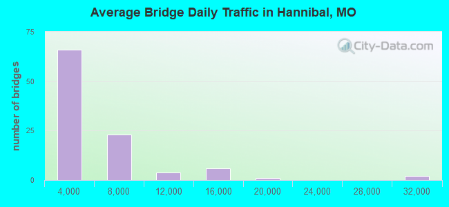
- 396,550Total average daily traffic
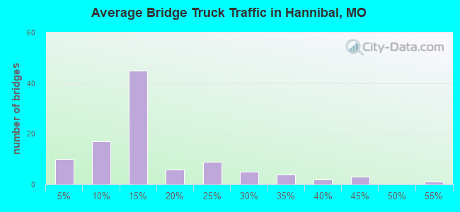
- 76,218Total average daily truck traffic
- National Bridge Inventory (NBI) Registered Bridges for Hannibal
- No street view available for this location
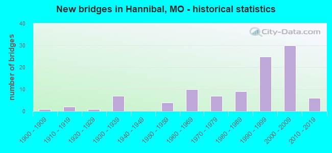
- New bridges - historical statistics
- 11900-1909
- 21910-1919
- 11920-1929
- 71930-1939
- 41950-1959
- 101960-1969
- 71970-1979
- 91980-1989
- 251990-1999
- 302000-2009
- 62010-2019
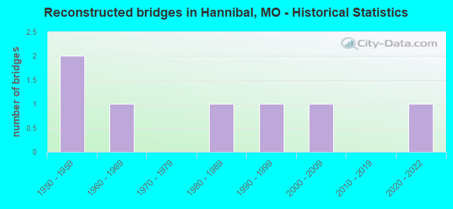
- Reconstructed bridges - Historical Statistics
- 21950-1959
- 11960-1969
- 01970-1979
- 11980-1989
- 11990-1999
- 12000-2009
- 02010-2019
- 12020-2022
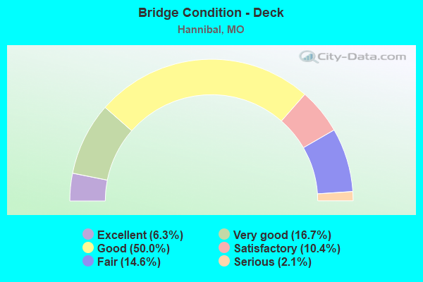
- Bridge Condition - Deck
- 6.3%Excellent
- 16.7%Very good
- 50.0%Good
- 10.4%Satisfactory
- 14.6%Fair
- 2.1%Serious
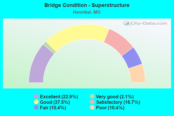
- Bridge Condition - Superstructure
- 22.9%Excellent
- 2.1%Very good
- 37.5%Good
- 16.7%Satisfactory
- 10.4%Fair
- 10.4%Poor
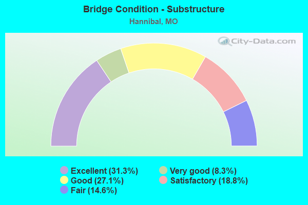
- Bridge Condition - Substructure
- 31.3%Excellent
- 8.3%Very good
- 27.1%Good
- 18.8%Satisfactory
- 14.6%Fair
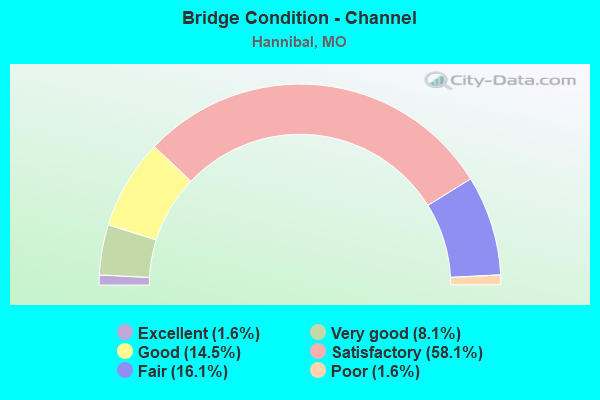
- Bridge Condition - Channel
- 1.6%Excellent
- 8.1%Very good
- 14.5%Good
- 58.1%Satisfactory
- 16.1%Fair
- 1.6%Poor
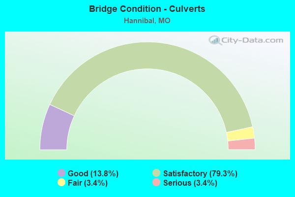
- Bridge Condition - Culverts
- 13.8%Good
- 79.3%Satisfactory
- 3.4%Fair
- 3.4%Serious
Find on map >> Show street view
Structure Number: 4156, Location: S 19 T 57 N R 4 W (Lat: 39.715378, Lng: -91.381558), Route carried "under" structure: City street , Year Built: 1993, Structure Length: 0. m, Average Daily Traffic: 1,724 (year 2021), Truck Traffic: 1%, Features Intersected: CST CENTRAL AVE, Facility Carried by Structure: IS 72 E
Minimum Vertical Clearance: 4.42m (14.50ft), Kilometerpoint: 0.821, Lanes on structure: 2, Lanes under structure: 2, Material/Design: Prestressed concrete continuous, Design/Construction: Stringer/Multi-beam, Length of Maximum Span: 15.5m (50.9ft)
Find on map >> Show street view
Structure Number: 4283, Location: S 192 T 57 N R 4 W (Lat: 39.717064, Lng: -91.372831), Route carried "under" structure: State highway 79, Year Built: 1997, Structure Length: 0. m, Average Daily Traffic: 12,470 (year 2021), Truck Traffic: 3%, Features Intersected: MO 79, Facility Carried by Structure: IS 72 E
Minimum Vertical Clearance: 5.61m (18.41ft), Kilometerpoint: 141.437, Lanes on structure: 2, Lanes under structure: 2, Material/Design: Prestressed concrete continuous, Design/Construction: Stringer/Multi-beam, Length of Maximum Span: 28.3m (92.8ft)
Find on map >> Show street view
Structure Number: 4284, Location: S 192 T 57 N R 4 W (Lat: 39.717161, Lng: -91.372908), Route carried "under" structure: State highway 79, Year Built: 1997, Structure Length: 0. m, Average Daily Traffic: 12,470 (year 2021), Truck Traffic: 3%, Features Intersected: MO 79, Facility Carried by Structure: IS 72 W
Minimum Vertical Clearance: 5.00m (16.40ft), Kilometerpoint: 141.450, Lanes on structure: 2, Lanes under structure: 2, Material/Design: Prestressed concrete continuous, Design/Construction: Stringer/Multi-beam, Length of Maximum Span: 28.3m (92.8ft)
Find on map >> Show street view
Structure Number: 4285, Location: S 19 T 57 N R 4 W (Lat: 39.716114, Lng: -91.377972), Route carried "under" structure: Interstate 72, Year Built: 1995, Structure Length: 0. m, Average Daily Traffic: 7,319 (year 2021), Truck Traffic: 26%, Features Intersected: IS 72, Facility Carried by Structure: COUNTRY CLUB DR S
Minimum Vertical Clearance: 7.14m (23.43ft), Kilometerpoint: 1.518, Lanes on structure: 2, Lanes under structure: 2, Material/Design: Steel continuous, Design/Construction: Stringer/Multi-beam, Length of Maximum Span: 31.5m (103.3ft)
Find on map >> Show street view
Structure Number: 4285, Location: S 19 T 57 N R 4 W (Lat: 39.716114, Lng: -91.377972), Route carried "under" structure: Interstate 72, Year Built: 1995, Structure Length: 0. m, Average Daily Traffic: 7,453 (year 2021), Truck Traffic: 23%, Features Intersected: IS 72, Facility Carried by Structure: COUNTRY CLUB DR S
Minimum Vertical Clearance: 7.14m (23.43ft), Kilometerpoint: 1.785, Lanes on structure: 2, Lanes under structure: 2, Material/Design: Steel continuous, Design/Construction: Stringer/Multi-beam, Length of Maximum Span: 31.5m (103.3ft)
Find on map >> Show street view
Structure Number: 655, Location: S 29 T 57 N R 4 W (Lat: 39.713103, Lng: -91.362269), Route carried "under" structure: State highway 79, Year Built: 1956, Structure Length: 0. m, Average Daily Traffic: 12,522 (year 2021), Truck Traffic: 7%, Features Intersected: MO 79, Facility Carried by Structure: RESERVOIR ST S
Minimum Vertical Clearance: 7.14m (23.43ft), Kilometerpoint: 1.186, Lanes on structure: 2, Lanes under structure: 4, Material/Design: Steel continuous, Design/Construction: Stringer/Multi-beam, Length of Maximum Span: 30.2m (99.1ft)
Find on map >> Show street view
Structure Number: 842, Location: S 28 T 57 N R 4 W (Lat: 39.706850, Lng: -91.355175), Route carried "under" structure: City street , Year Built: 1966, Structure Length: 0. m, Average Daily Traffic: 1,218 (year 2021), Truck Traffic: 4%, Features Intersected: CST WARREN BARRETT DR, Facility Carried by Structure: MO 79 S
Minimum Vertical Clearance: 6.81m (22.34ft), Kilometerpoint: 6.117, Lanes on structure: 2, Lanes under structure: 2, Material/Design: Steel continuous, Design/Construction: Stringer/Multi-beam, Length of Maximum Span: 28.0m (91.9ft)
Find on map >> Show street view
Structure Number: 842, Location: S 28 T 57 N R 4 W (Lat: 39.706850, Lng: -91.355175), Route carried "under" structure: City street , Year Built: 1966, Structure Length: 0. m, Average Daily Traffic: 990 (year 2021), Truck Traffic: 5%, Features Intersected: CST LYON ST, Facility Carried by Structure: MO 79 S
Minimum Vertical Clearance: 3.56m (11.68ft), Kilometerpoint: 1.426, Lanes on structure: 2, Lanes under structure: 1, Material/Design: Steel continuous, Design/Construction: Stringer/Multi-beam, Length of Maximum Span: 28.0m (91.9ft)