Bridge Statistics for Holyoke, Massachusetts (MA)
Condition, Traffic, Stress, Structural Evaluation, Project Costs
- National Bridge Inventory (NBI) Statistics
- 51Number of bridges
- 1,102ft / 336mTotal length
- $344,437,000Total costs
- 1,213,779Total average daily traffic
- 70,682Total average daily truck traffic
- National Bridge Inventory (NBI) Registered Bridges for Holyoke
- No street view available for this location
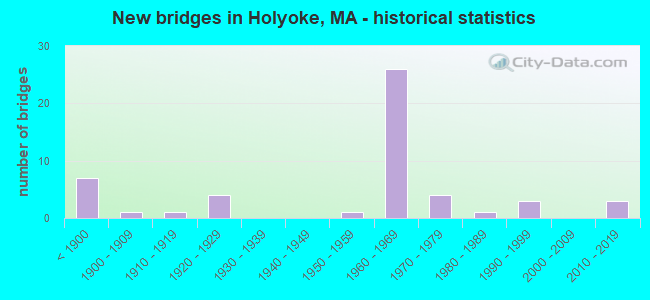
- New bridges - historical statistics
- 7Before 1900
- 11900-1909
- 11910-1919
- 41920-1929
- 11950-1959
- 261960-1969
- 41970-1979
- 11980-1989
- 31990-1999
- 32010-2019
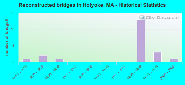
- Reconstructed bridges - Historical Statistics
- 11910-1919
- 21920-1929
- 11930-1939
- 01940-1949
- 01950-1959
- 01960-1969
- 01970-1979
- 131980-1989
- 31990-1999
- 12000-2009
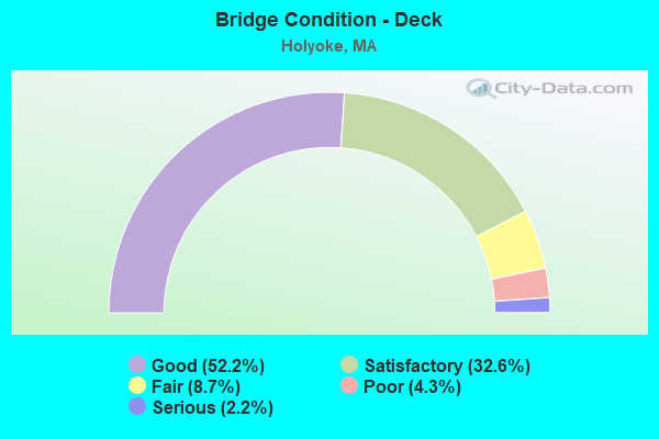
- Bridge Condition - Deck
- 52.2%Good
- 32.6%Satisfactory
- 8.7%Fair
- 4.3%Poor
- 2.2%Serious
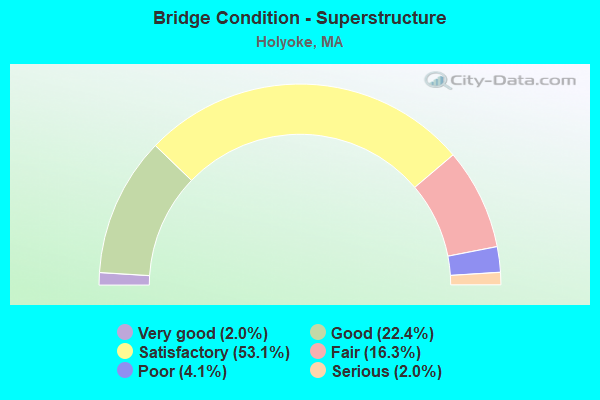
- Bridge Condition - Superstructure
- 2.0%Very good
- 22.4%Good
- 53.1%Satisfactory
- 16.3%Fair
- 4.1%Poor
- 2.0%Serious
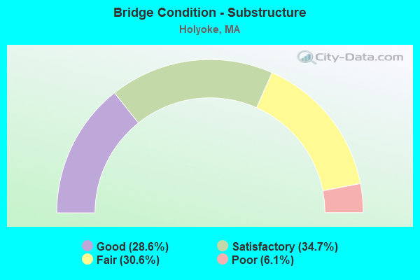
- Bridge Condition - Substructure
- 28.6%Good
- 34.7%Satisfactory
- 30.6%Fair
- 6.1%Poor
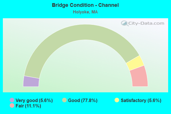
- Bridge Condition - Channel
- 5.6%Very good
- 77.8%Good
- 5.6%Satisfactory
- 11.1%Fair
Find on map >> Show street view
Structure Number: H210520YKDOTNBI, Location: MM 15.1 ON I-91 SB (Lat: 42.211417, Lng: -72.633833), Route carried "on" structure: Interstate 91, Year Built: 1965, Year Reconstructed: 1986, Status: Open, Structure Length: 2.72m (8.92ft), Average Daily Traffic: 31,810 (year 2017), Truck Traffic: 5%, Average Future Daily Traffic: 100,759 (year 2032), Design Load: HS 20+Mod, Features Intersected: ST141 EB
Minimum Vertical Clearance: 30+ m (98+ ft), Kilometerpoint: 24.300, Lanes on structure: 2, Lanes under structure: 1, Base Highway Network: Yes, Owner: State Highway Agency, Approaching Roadway Width: 11.3m (37.1ft), Skew: 3 degrees, Material/Design: Steel, Design/Construction: Stringer/Multi-beam, Number Of Spans In Main Unit: 1, Length of Maximum Span: 26.0m (85.3ft), Curb-To-Curb Width: 12.2m (40.0ft), Out-to-Out Width: 13.2m (43.3ft)
Condition: Deck: Good, Superstructure: Satisfactory, Substructure: Satisfactory, Operating Rating: 75.1 metric tons, Method Used To Determine Operating Rating: Load Factor (LF), Inventory Rating: 45.0 metric tons, Method Used To Determine Inventory Rating: Load Factor (LF), Structural Evaluation: Equal to present minimum criteria, Deck Geometry: Better than present minimum criteria, Underclear: High priority of corrective action, Approach Roadway Alignment: Equal to present desirable criteria, Length Of Structure Improvement: 2.80m (9.19ft), Designated Inspection Frequency: Every 24 months, Inspection Date: December 2021, Bridge Improvement Cost: $159,000, Roadway Improvement Cost: $16,000, Total Project Cost: $239,000 ( Estimate for 2022), Deck Structure Type: Concrete Cast-file-Place, Wearing Surface/Protective System: Wearing Surface: Bituminous, Membrane: Built-up, Deck Protection: Epoxy Coated Reinforcing
Find on map >> Show street view
Structure Number: H210530YLDOTNBI, Location: MM 15.2 ON I-91 NB (Lat: 42.212928, Lng: -72.632708), Route carried "on" structure: Interstate 91, Year Built: 1965, Year Reconstructed: 1986, Status: Open, Structure Length: 2.78m (9.12ft), Average Daily Traffic: 27,094 (year 2016), Truck Traffic: 8%, Average Future Daily Traffic: 113,552 (year 2032), Design Load: HS 20+Mod, Features Intersected: ST141 WB
Minimum Vertical Clearance: 30+ m (98+ ft), Kilometerpoint: 24.494, Lanes on structure: 2, Lanes under structure: 2, Base Highway Network: Yes, Owner: State Highway Agency, Approaching Roadway Width: 13.3m (43.6ft), Skew: 1 degrees, Material/Design: Steel, Design/Construction: Stringer/Multi-beam, Number Of Spans In Main Unit: 1, Length of Maximum Span: 26.3m (86.3ft), Curb-To-Curb Width: 13.3m (43.6ft), Out-to-Out Width: 14.2m (46.6ft)
Condition: Deck: Good, Superstructure: Satisfactory, Substructure: Fair, Operating Rating: 75.3 metric tons, Method Used To Determine Operating Rating: Load Factor (LF), Inventory Rating: 45.1 metric tons, Method Used To Determine Inventory Rating: Load Factor (LF), Structural Evaluation: Somewhat better than minimum adequacy, Deck Geometry: Superior to present desirable criteria, Underclear: Somewhat better than minimum adequacy, Approach Roadway Alignment: Equal to present desirable criteria, Length Of Structure Improvement: 2.80m (9.19ft), Designated Inspection Frequency: Every 24 months, Inspection Date: October 2021, Bridge Improvement Cost: $1,562,000, Roadway Improvement Cost: $157,000, Total Project Cost: $2,344,000 ( Estimate for 2022), Deck Structure Type: Concrete Cast-file-Place, Wearing Surface/Protective System: Wearing Surface: Bituminous, Membrane: Built-up, Deck Protection: Epoxy Coated Reinforcing
Find on map >> Show street view
Structure Number: H210530YMDOTNBI, Location: MM 15.2 ON I-91 SB (Lat: 42.212931, Lng: -72.633092), Route carried "on" structure: Interstate 91, Year Built: 1965, Year Reconstructed: 1986, Status: Open, Structure Length: 2.78m (9.12ft), Average Daily Traffic: 24,566 (year 2016), Truck Traffic: 8%, Average Future Daily Traffic: 113,552 (year 2032), Design Load: HS 20+Mod, Features Intersected: ST141 WB
Minimum Vertical Clearance: 30+ m (98+ ft), Kilometerpoint: 24.494, Lanes on structure: 2, Lanes under structure: 2, Base Highway Network: Yes, Owner: State Highway Agency, Approaching Roadway Width: 12.2m (40.0ft), Skew: 1 degrees, Material/Design: Steel, Design/Construction: Stringer/Multi-beam, Number Of Spans In Main Unit: 1, Length of Maximum Span: 26.3m (86.3ft), Curb-To-Curb Width: 12.2m (40.0ft), Out-to-Out Width: 13.2m (43.3ft)
Condition: Deck: Good, Superstructure: Satisfactory, Substructure: Fair, Operating Rating: 75.9 metric tons, Method Used To Determine Operating Rating: Load Factor (LF), Inventory Rating: 45.5 metric tons, Method Used To Determine Inventory Rating: Load Factor (LF), Structural Evaluation: Somewhat better than minimum adequacy, Deck Geometry: Better than present minimum criteria, Underclear: Meets minimum limits, Approach Roadway Alignment: Equal to present desirable criteria, Length Of Structure Improvement: 2.80m (9.19ft), Designated Inspection Frequency: Every 24 months, Inspection Date: October 2021, Bridge Improvement Cost: $1,452,000, Roadway Improvement Cost: $146,000, Total Project Cost: $2,179,000 ( Estimate for 2022), Deck Structure Type: Concrete Cast-file-Place, Wearing Surface/Protective System: Wearing Surface: Bituminous, Membrane: Built-up, Deck Protection: Epoxy Coated Reinforcing
Find on map >> Show street view
Structure Number: H210540YNDOTNBI, Location: MM 16.0 ON I-91 NB (Lat: 42.223492, Lng: -72.636403), Route carried "on" structure: Interstate 91, Year Built: 1965, Year Reconstructed: 1986, Status: Open, Structure Length: 2.31m (7.58ft), Average Daily Traffic: 27,900 (year 2018), Truck Traffic: 6%, Average Future Daily Traffic: 100,759 (year 2032), Design Load: HS 20+Mod, Features Intersected: HWY BEMIS RD
Minimum Vertical Clearance: 30+ m (98+ ft), Kilometerpoint: 25.749, Lanes on structure: 2, Lanes under structure: 2, Base Highway Network: Yes, Owner: State Highway Agency, Approaching Roadway Width: 11.3m (37.1ft), Skew: 1 degrees, Material/Design: Steel, Design/Construction: Stringer/Multi-beam, Number Of Spans In Main Unit: 1, Length of Maximum Span: 21.8m (71.5ft), Curb-To-Curb Width: 12.2m (40.0ft), Out-to-Out Width: 13.2m (43.3ft)
Condition: Deck: Good, Superstructure: Fair, Substructure: Satisfactory, Operating Rating: 67.1 metric tons, Method Used To Determine Operating Rating: Load Factor (LF), Inventory Rating: 40.2 metric tons, Method Used To Determine Inventory Rating: Load Factor (LF), Structural Evaluation: Somewhat better than minimum adequacy, Deck Geometry: Better than present minimum criteria, Underclear: Meets minimum limits, Approach Roadway Alignment: Equal to present desirable criteria, Length Of Structure Improvement: 2.40m (7.87ft), Designated Inspection Frequency: Every 24 months, Inspection Date: October 2021, Bridge Improvement Cost: $1,245,000, Roadway Improvement Cost: $125,000, Total Project Cost: $1,868,000 ( Estimate for 2022), Deck Structure Type: Concrete Cast-file-Place, Wearing Surface/Protective System: Wearing Surface: Bituminous, Membrane: Built-up
Find on map >> Show street view
Structure Number: H210540YPDOTNBI, Location: MM 16.0 ON I-91 SB (Lat: 42.223478, Lng: -72.636778), Route carried "on" structure: Interstate 91, Year Built: 1965, Year Reconstructed: 1986, Status: Open, Structure Length: 2.31m (7.58ft), Average Daily Traffic: 27,500 (year 2018), Truck Traffic: 5%, Average Future Daily Traffic: 100,759 (year 2032), Design Load: HS 20+Mod, Features Intersected: HWY BEMIS RD
Minimum Vertical Clearance: 30+ m (98+ ft), Kilometerpoint: 25.749, Lanes on structure: 2, Lanes under structure: 2, Base Highway Network: Yes, Owner: State Highway Agency, Approaching Roadway Width: 11.3m (37.1ft), Skew: 1 degrees, Material/Design: Steel, Design/Construction: Stringer/Multi-beam, Number Of Spans In Main Unit: 1, Length of Maximum Span: 21.8m (71.5ft), Curb-To-Curb Width: 12.2m (40.0ft), Out-to-Out Width: 13.2m (43.3ft)
Condition: Deck: Good, Superstructure: Satisfactory, Substructure: Satisfactory, Operating Rating: 67.1 metric tons, Method Used To Determine Operating Rating: Load Factor (LF), Inventory Rating: 40.2 metric tons, Method Used To Determine Inventory Rating: Load Factor (LF), Structural Evaluation: Equal to present minimum criteria, Deck Geometry: Better than present minimum criteria, Underclear: Meets minimum limits, Approach Roadway Alignment: Equal to present desirable criteria, Length Of Structure Improvement: 2.40m (7.87ft), Designated Inspection Frequency: Every 24 months, Inspection Date: October 2021, Bridge Improvement Cost: $136,000, Roadway Improvement Cost: $14,000, Total Project Cost: $205,000 ( Estimate for 2022), Deck Structure Type: Concrete Cast-file-Place, Wearing Surface/Protective System: Wearing Surface: Bituminous, Membrane: Built-up, Deck Protection: Epoxy Coated Reinforcing
Find on map >> Show street view
Structure Number: H210550YHDOTNBI, Location: MM 15.2 ON I-91 SB (Lat: 42.211844, Lng: -72.634142), Route carried "on" structure: Ramp Interstate 91, Year Built: 1965, Status: Open, Structure Length: 5.55m (18.21ft), Average Daily Traffic: 5,379 (year 2015), Truck Traffic: 5%, Average Future Daily Traffic: 15,161 (year 2032), Design Load: HS 20, Features Intersected: ST141 EB
Minimum Vertical Clearance: 30+ m (98+ ft), Kilometerpoint: 0.000, Lanes on structure: 1, Lanes under structure: 1, Base Highway Network: Yes, Owner: State Highway Agency, Approaching Roadway Width: 6.7m (22.0ft), Skew: 5 degrees, Material/Design: Steel, Design/Construction: Stringer/Multi-beam, Number Of Spans In Main Unit: 3, Length of Maximum Span: 21.6m (70.9ft), Curb-To-Curb Width: 6.7m (22.0ft), Out-to-Out Width: 8.4m (27.6ft)
Condition: Deck: Satisfactory, Superstructure: Satisfactory, Substructure: Satisfactory, Operating Rating: 57.0 metric tons, Method Used To Determine Operating Rating: Load Factor (LF), Inventory Rating: 34.1 metric tons, Method Used To Determine Inventory Rating: Load Factor (LF), Structural Evaluation: Equal to present minimum criteria, Deck Geometry: Equal to present minimum criteria, Underclear: High priority of corrective action, Approach Roadway Alignment: Better than present minimum criteria, Length Of Structure Improvement: 5.60m (18.37ft), Designated Inspection Frequency: Every 24 months, Inspection Date: October 2021, Bridge Improvement Cost: $634,000, Roadway Improvement Cost: $64,000, Total Project Cost: $952,000 ( Estimate for 2022), Deck Structure Type: Concrete Cast-file-Place, Wearing Surface/Protective System: Wearing Surface: Bituminous, Membrane: Built-up
Find on map >> Show street view
Structure Number: H2105713FDOTNBI, Location: MM 11.9 ON I-91 (Lat: 42.166969, Lng: -72.644053), Route carried "on" structure: City street , Year Built: 1967, Status: Open, Structure Length: 6.55m (21.49ft), Average Daily Traffic: 13,344 (year 2018), Truck Traffic: 5%, Average Future Daily Traffic: 9,476 (year 2032), Design Load: H 20, Features Intersected: I 91, Facility Carried by Structure: HWY WHITNEY AVE
Minimum Vertical Clearance: 30+ m (98+ ft), Kilometerpoint: 19.135, Lanes on structure: 2, Lanes under structure: 6, Owner: State Highway Agency, Approaching Roadway Width: 12.2m (40.0ft), Skew: 2 degrees, Material/Design: Steel, Design/Construction: Stringer/Multi-beam, Number Of Spans In Main Unit: 2, Length of Maximum Span: 32.1m (105.3ft), Curb or Sidewalk Widths: Left: 1.5m (4.9ft), Right: 0.0m, Curb-To-Curb Width: 12.2m (40.0ft), Out-to-Out Width: 15.0m (49.2ft)
Condition: Deck: Fair, Superstructure: Fair, Substructure: Satisfactory, Operating Rating: 55.9 metric tons, Method Used To Determine Operating Rating: Allowable Stress (AS), Inventory Rating: 30.7 metric tons, Method Used To Determine Inventory Rating: Allowable Stress (AS), Structural Evaluation: Somewhat better than minimum adequacy, Deck Geometry: Somewhat better than minimum adequacy, Underclear: High priority of corrective action, Approach Roadway Alignment: Equal to present desirable criteria, Length Of Structure Improvement: 6.60m (21.65ft), Designated Inspection Frequency: Every 24 months, Inspection Date: March 2021, Bridge Improvement Cost: $3,889,000, Roadway Improvement Cost: $389,000, Total Project Cost: $5,834,000 ( Estimate for 2022), Deck Structure Type: Concrete Cast-file-Place, Wearing Surface/Protective System: Wearing Surface: Bituminous, Membrane: Built-up
Find on map >> Show street view
Structure Number: H210580Y5DOTNBI, Location: MM 11.5 ON I-91 NB (Lat: 42.162328, Lng: -72.646081), Route carried "on" structure: Interstate 91, Year Built: 1967, Status: Open, Structure Length: 3.78m (12.40ft), Average Daily Traffic: 36,164 (year 2018), Truck Traffic: 10%, Average Future Daily Traffic: 93,179 (year 2032), Design Load: HS 20+Mod, Features Intersected: I 91 RMP A TPK CONN
Minimum Vertical Clearance: 30+ m (98+ ft), Kilometerpoint: 18.748, Lanes on structure: 3, Lanes under structure: 2, Base Highway Network: Yes, Owner: State Highway Agency, Approaching Roadway Width: 15.2m (49.9ft), Material/Design: Steel, Design/Construction: Stringer/Multi-beam, Number Of Spans In Main Unit: 2, Length of Maximum Span: 18.1m (59.4ft), Curb-To-Curb Width: 15.2m (49.9ft), Out-to-Out Width: 17.1m (56.1ft)
Condition: Deck: Satisfactory, Superstructure: Fair, Substructure: Fair, Operating Rating: 54.6 metric tons, Method Used To Determine Operating Rating: Allowable Stress (AS), Inventory Rating: 34.3 metric tons, Method Used To Determine Inventory Rating: Allowable Stress (AS), Structural Evaluation: Somewhat better than minimum adequacy, Deck Geometry: Meets minimum limits, Underclear: Meets minimum limits, Approach Roadway Alignment: Equal to present desirable criteria, Length Of Structure Improvement: 3.80m (12.47ft), Designated Inspection Frequency: Every 24 months, Inspection Date: June 2021, Bridge Improvement Cost: $2,553,000, Roadway Improvement Cost: $256,000, Total Project Cost: $3,830,000 ( Estimate for 2022), Deck Structure Type: Concrete Cast-file-Place, Wearing Surface/Protective System: Wearing Surface: Bituminous, Membrane: Preformed Fabric
Find on map >> Show street view
Structure Number: H210580Y6DOTNBI, Location: MM 11.5 ON I-91 SB (Lat: 42.162461, Lng: -72.646439), Route carried "on" structure: Interstate 91, Year Built: 1967, Status: Open, Structure Length: 3.79m (12.43ft), Average Daily Traffic: 37,102 (year 2018), Truck Traffic: 10%, Average Future Daily Traffic: 93,179 (year 2032), Design Load: HS 20+Mod, Features Intersected: I 91 RMP A TPK CONN
Minimum Vertical Clearance: 30+ m (98+ ft), Kilometerpoint: 18.748, Lanes on structure: 4, Lanes under structure: 2, Base Highway Network: Yes, Owner: State Highway Agency, Approaching Roadway Width: 15.8m (51.8ft), Material/Design: Steel, Design/Construction: Stringer/Multi-beam, Number Of Spans In Main Unit: 2, Length of Maximum Span: 18.1m (59.4ft), Curb-To-Curb Width: 15.8m (51.8ft), Out-to-Out Width: 17.7m (58.1ft)
Condition: Deck: Fair, Superstructure: Fair, Substructure: Fair, Operating Rating: 60.8 metric tons, Method Used To Determine Operating Rating: Load Factor (LF), Structural Evaluation: High priority of corrective action, Deck Geometry: High priority of replacement, Underclear: Meets minimum limits, Approach Roadway Alignment: Equal to present desirable criteria, Length Of Structure Improvement: 3.80m (12.47ft), Designated Inspection Frequency: Every 24 months, Inspection Date: June 2021, Bridge Improvement Cost: $2,642,000, Roadway Improvement Cost: $265,000, Total Project Cost: $3,964,000 ( Estimate for 2022), Deck Structure Type: Concrete Cast-file-Place, Wearing Surface/Protective System: Wearing Surface: Bituminous, Membrane: Preformed Fabric
Find on map >> Show street view
Structure Number: H210600WTDOTNBI, Location: .1 M N JCT CONN RIVER (Lat: 42.193839, Lng: -72.613147), Route carried "on" structure: Interstate 391, Year Built: 1980, Status: Open, Structure Length: 78.01m (255.94ft), Average Daily Traffic: 38,678 (year 2019), Truck Traffic: 14%, Average Future Daily Traffic: 50,380 (year 2031), Design Load: HS 20+Mod, Features Intersected: COMB MAIN ST & PVRR
Minimum Vertical Clearance: 4.75m (15.58ft), Kilometerpoint: 0.483, Lanes on structure: 6, Lanes under structure: 8, Base Highway Network: Yes, Owner: State Highway Agency, Approaching Roadway Width: 33.9m (111.2ft), Skew: 39 degrees, Material/Design: Steel continuous, Design/Construction: Stringer/Multi-beam, Number Of Spans In Main Unit: 18, Number Of Approach Spans: 6, Length of Maximum Span: 41.1m (134.8ft), Curb-To-Curb Width: 32.3m (106.0ft), Out-to-Out Width: 33.9m (111.2ft)
Condition: Deck: Fair, Superstructure: Fair, Substructure: Fair, Operating Rating: 51.4 metric tons, Method Used To Determine Operating Rating: Load Factor (LF), Inventory Rating: 30.8 metric tons, Method Used To Determine Inventory Rating: Load Factor (LF), Structural Evaluation: Somewhat better than minimum adequacy, Deck Geometry: Meets minimum limits, Underclear: Meets minimum limits, Approach Roadway Alignment: Equal to present desirable criteria, Length Of Structure Improvement: 78.10m (256.23ft), Designated Inspection Frequency: Every 24 months, Critical Feature Inspection Frequency: Every 24 months, Inspection Date: July 2020, Critical Feature Inspection Date: July 2020, Bridge Improvement Cost: $104,090,000, Roadway Improvement Cost: $10,410,000, Total Project Cost: $156,136,000 ( Estimate for 2022), Deck Structure Type: Concrete Cast-file-Place, Wearing Surface/Protective System: Wearing Surface: Bituminous, Membrane: Built-up
Find on map >> Show street view
Structure Number: H21066AHPMUNNBI, Location: 400' NE OF SOUTH STREET (Lat: 42.194792, Lng: -72.613658), Route carried "on" structure: City street , Year Built: 1850, Status: Open, Structure Length: 0.98m (3.22ft), Average Daily Traffic: 905 (year 2019), Truck Traffic: 6%, Average Future Daily Traffic: 395 (year 2032), Features Intersected: WATER THIRD LEVEL CANAL, Facility Carried by Structure: HWY RACE ST
Minimum Vertical Clearance: 30+ m (98+ ft), Kilometerpoint: 0.000, Lanes on structure: 2, Owner: City or Municipal Highway Agency, Approaching Roadway Width: 10.1m (33.1ft), Material/Design: Masonry, Design/Construction: Arch - Deck, Number Of Spans In Main Unit: 2, Length of Maximum Span: 4.6m (15.1ft), Curb-To-Curb Width: 9.4m (30.8ft), Out-to-Out Width: 24.2m (79.4ft)
Condition: Superstructure: Good, Substructure: Satisfactory, Channel: Good, Operating Rating: 29.2 metric tons, Method Used To Determine Operating Rating: Allowable Stress (AS), Inventory Rating: 29.2 metric tons, Method Used To Determine Inventory Rating: Allowable Stress (AS), Structural Evaluation: Equal to present minimum criteria, Deck Geometry: Equal to present minimum criteria, Waterway Adequacy: Equal to present desirable criteria, Approach Roadway Alignment: Equal to present desirable criteria, Bridge Posting: Required (Relationship of Operating Rating to Maximum Legal Load: 0.1 - 9.9% below), Length Of Structure Improvement: 1.00m (3.28ft), Designated Inspection Frequency: Every 24 months, Inspection Date: September 2021, Underwater Inspection Date: March 2020, Bridge Improvement Cost: $951,000, Roadway Improvement Cost: $96,000, Total Project Cost: $1,427,000 ( Estimate for 2022)
Find on map >> Show street view
Structure Number: H21067AHKMUNNBI, Location: AT JCT. OF MAIN STREET (Lat: 42.195719, Lng: -72.611686), Route carried "on" structure: City street , Year Built: 1850, Year Reconstructed: 1920, Status: Posted for load, Structure Length: 0.98m (3.22ft), Average Daily Traffic: 6,466 (year 2019), Truck Traffic: 4%, Average Future Daily Traffic: 7,352 (year 2032), Features Intersected: WATER THIRD LVL CNL SPWY, Facility Carried by Structure: HWY JACKSON ST
Minimum Vertical Clearance: 30+ m (98+ ft), Kilometerpoint: 0.000, Lanes on structure: 2, Owner: City or Municipal Highway Agency, Approaching Roadway Width: 12.3m (40.4ft), Material/Design: Masonry, Design/Construction: Arch - Deck, Number Of Spans In Main Unit: 1, Length of Maximum Span: 9.8m (32.2ft), Curb or Sidewalk Widths: Left: 2.9m (9.5ft), Right: 2.6m (8.5ft), Curb-To-Curb Width: 12.3m (40.4ft), Out-to-Out Width: 19.5m (64.0ft)
Condition: Superstructure: Satisfactory, Substructure: Satisfactory, Channel: Good, Operating Rating: 43.2 metric tons, Method Used To Determine Operating Rating: Allowable Stress (AS), Inventory Rating: 43.2 metric tons, Method Used To Determine Inventory Rating: Allowable Stress (AS), Structural Evaluation: Equal to present minimum criteria, Deck Geometry: Somewhat better than minimum adequacy, Waterway Adequacy: Better than present minimum criteria, Approach Roadway Alignment: Equal to present desirable criteria, Length Of Structure Improvement: 1.00m (3.28ft), Designated Inspection Frequency: Every 24 months, Inspection Date: September 2021, Bridge Improvement Cost: $104,000, Roadway Improvement Cost: $11,000, Total Project Cost: $157,000 ( Estimate for 2022), Wearing Surface/Protective System: Wearing Surface: Bituminous
Find on map >> Show street view
Structure Number: W21042157DOTNBI, Location: JCT RAMP 'F' TO I-90 (Lat: 42.166667, Lng: -72.633333), Route carried "under" structure: Ramp Interstate 90, Year Built: 1970, Structure Length: 0. m, Average Daily Traffic: 10,000 (year 0000), Features Intersected: HWY RAMP F TO I 90
Minimum Vertical Clearance: 4.44m (14.57ft), Kilometerpoint: 73.545, Lanes on structure: 1, Lanes under structure: 2, Toll: On toll road, Material/Design: Steel, Design/Construction: Stringer/Multi-beam, Length of Maximum Span: 20.1m (65.9ft)