Bridge Statistics for Huntsville, Alabama (AL)
Condition, Traffic, Stress, Structural Evaluation, Project Costs
- National Bridge Inventory (NBI) Statistics
- 639Number of bridges
- 11,867ft / 3,617mTotal length
- $1,521,431,000Total costs
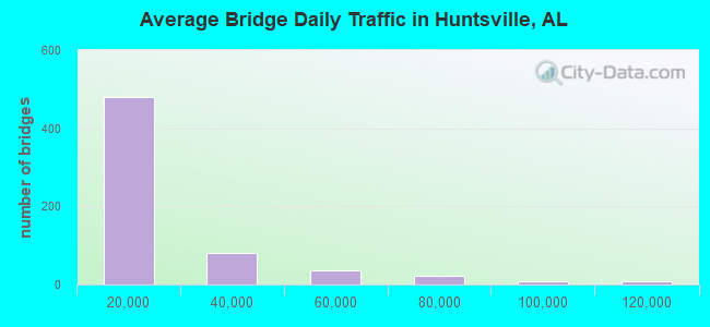
- 10,240,811Total average daily traffic
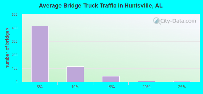
- 528,271Total average daily truck traffic
- National Bridge Inventory (NBI) Registered Bridges for Huntsville
- No street view available for this location
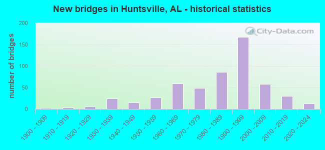
- New bridges - historical statistics
- 21900-1909
- 31910-1919
- 131920-1929
- 381930-1939
- 241940-1949
- 421950-1959
- 711960-1969
- 551970-1979
- 1011980-1989
- 1771990-1999
- 662000-2009
- 352010-2019
- 122020-2022
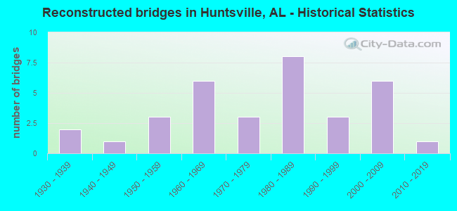
- Reconstructed bridges - Historical Statistics
- 21930-1939
- 11940-1949
- 31950-1959
- 61960-1969
- 31970-1979
- 81980-1989
- 31990-1999
- 62000-2009
- 12010-2019
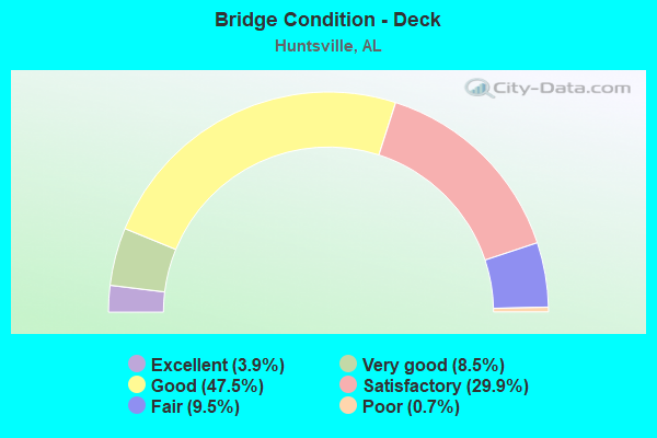
- Bridge Condition - Deck
- 3.9%Excellent
- 8.5%Very good
- 47.5%Good
- 29.9%Satisfactory
- 9.5%Fair
- 0.7%Poor
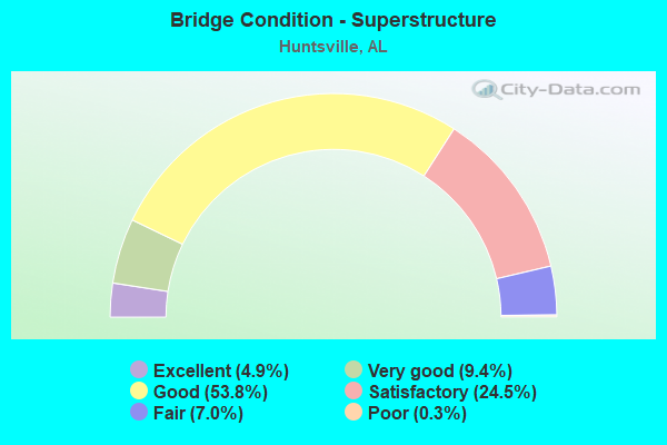
- Bridge Condition - Superstructure
- 4.9%Excellent
- 9.4%Very good
- 53.8%Good
- 24.5%Satisfactory
- 7.0%Fair
- 0.3%Poor
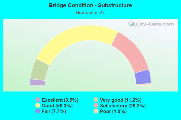
- Bridge Condition - Substructure
- 3.5%Excellent
- 11.2%Very good
- 50.3%Good
- 26.2%Satisfactory
- 7.7%Fair
- 1.0%Poor
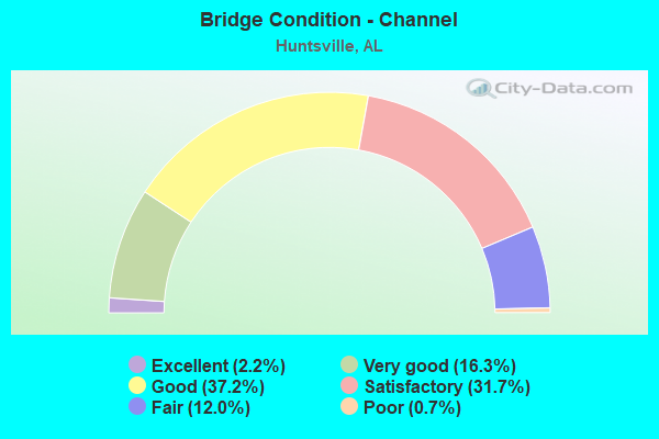
- Bridge Condition - Channel
- 2.2%Excellent
- 16.3%Very good
- 37.2%Good
- 31.7%Satisfactory
- 12.0%Fair
- 0.7%Poor
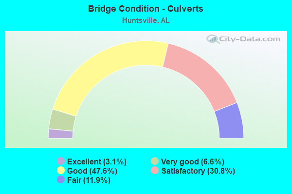
- Bridge Condition - Culverts
- 3.1%Excellent
- 6.6%Very good
- 47.6%Good
- 30.8%Satisfactory
- 11.9%Fair
Find on map >> Show street view
Structure Number: 15821, Location: 1.3 MI E JCT I565 * SR53 (Lat: 34.726667, Lng: -86.606667), Route carried "under" structure: Spur Interstate 565, Year Built: 1991, Structure Length: 0. m, Average Daily Traffic: 1,000 (year 2018), Truck Traffic: 1%, Features Intersected: N/S R.R / CITY STREETS
Minimum Vertical Clearance: 7.56m (24.80ft), Kilometerpoint: 28.983, Lanes on structure: 3, Lanes under structure: 3, Material/Design: Steel, Design/Construction: Stringer/Multi-beam, Length of Maximum Span: 67.4m (221.1ft)
Find on map >> Show street view
Structure Number: 15821, Location: 1.3 MI E JCT I565 * SR53 (Lat: 34.726667, Lng: -86.606667), Route carried "under" structure: Spur Interstate 565, Year Built: 1991, Structure Length: 0. m, Average Daily Traffic: 1,000 (year 2018), Truck Traffic: 1%, Features Intersected: N/S R.R / CITY STREETS
Minimum Vertical Clearance: 7.86m (25.79ft), Kilometerpoint: 28.983, Lanes on structure: 3, Lanes under structure: 2, Material/Design: Steel, Design/Construction: Stringer/Multi-beam, Length of Maximum Span: 67.4m (221.1ft)
Find on map >> Show street view
Structure Number: 15821, Location: 1.3 MI E JCT I565 * SR53 (Lat: 34.726667, Lng: -86.606667), Route carried "under" structure: Spur Interstate 565, Year Built: 1991, Structure Length: 0. m, Average Daily Traffic: 1,000 (year 2018), Truck Traffic: 1%, Features Intersected: N/S R.R / CITY STREETS
Minimum Vertical Clearance: 7.56m (24.80ft), Kilometerpoint: 28.983, Lanes on structure: 3, Lanes under structure: 8, Material/Design: Steel, Design/Construction: Stringer/Multi-beam, Length of Maximum Span: 67.4m (221.1ft)
Find on map >> Show street view
Structure Number: 15821, Location: 1.3 MI E JCT I565 * SR53 (Lat: 34.726667, Lng: -86.606667), Route carried "under" structure: Spur Interstate 565, Year Built: 1991, Structure Length: 0. m, Average Daily Traffic: 1,000 (year 2018), Truck Traffic: 1%, Features Intersected: N/S R.R / CITY STREETS
Minimum Vertical Clearance: 7.65m (25.10ft), Kilometerpoint: 28.983, Lanes on structure: 3, Lanes under structure: 5, Material/Design: Steel, Design/Construction: Stringer/Multi-beam, Length of Maximum Span: 67.4m (221.1ft)
Find on map >> Show street view
Structure Number: 15821, Location: 1.3 MI E JCT I565 * SR53 (Lat: 34.726667, Lng: -86.606667), Route carried "under" structure: Spur Interstate 565, Year Built: 1991, Structure Length: 0. m, Average Daily Traffic: 1,000 (year 2018), Truck Traffic: 1%, Features Intersected: N/S R.R / CITY STREETS
Minimum Vertical Clearance: 7.56m (24.80ft), Kilometerpoint: 28.983, Lanes on structure: 3, Lanes under structure: 5, Material/Design: Steel, Design/Construction: Stringer/Multi-beam, Length of Maximum Span: 67.4m (221.1ft)
Find on map >> Show street view
Structure Number: 15821, Location: 1.3 MI E JCT I565 * SR53 (Lat: 34.726667, Lng: -86.606667), Route carried "under" structure: City street , Year Built: 1991, Structure Length: 0. m, Average Daily Traffic: 1,000 (year 2018), Truck Traffic: 1%, Features Intersected: N/S R.R / CITY STREETS, Facility Carried by Structure: I-565; ALT US 72
Minimum Vertical Clearance: 6.16m (20.21ft), Kilometerpoint: 0.000, Lanes on structure: 3, Lanes under structure: 2, Material/Design: Steel, Design/Construction: Stringer/Multi-beam, Length of Maximum Span: 67.4m (221.1ft)
Find on map >> Show street view
Structure Number: 15821, Location: 1.3 MI E JCT I565 * SR53 (Lat: 34.726667, Lng: -86.606667), Route carried "under" structure: City street , Year Built: 1991, Structure Length: 0. m, Average Daily Traffic: 1,000 (year 2018), Truck Traffic: 1%, Features Intersected: N/S R.R / CITY STREETS, Facility Carried by Structure: I-565; ALT US 72
Minimum Vertical Clearance: 5.82m (19.09ft), Kilometerpoint: 0.000, Lanes on structure: 3, Lanes under structure: 2, Material/Design: Steel, Design/Construction: Stringer/Multi-beam, Length of Maximum Span: 67.4m (221.1ft)
Find on map >> Show street view
Structure Number: 15821, Location: 1.3 MI E JCT I565 * SR53 (Lat: 34.726667, Lng: -86.606667), Route carried "under" structure: City street , Year Built: 1991, Structure Length: 0. m, Average Daily Traffic: 1,000 (year 2018), Truck Traffic: 1%, Features Intersected: N/S R.R / CITY STREETS, Facility Carried by Structure: I-565; ALT US 72
Minimum Vertical Clearance: 6.04m (19.82ft), Kilometerpoint: 0.000, Lanes on structure: 3, Lanes under structure: 2, Material/Design: Steel, Design/Construction: Stringer/Multi-beam, Length of Maximum Span: 67.4m (221.1ft)
Find on map >> Show street view
Structure Number: 15821, Location: 1.3 MI E JCT I565 * SR53 (Lat: 34.726667, Lng: -86.606667), Route carried "under" structure: City street , Year Built: 1991, Structure Length: 0. m, Average Daily Traffic: 1,000 (year 2018), Truck Traffic: 1%, Features Intersected: N/S R.R / CITY STREETS, Facility Carried by Structure: I-565; ALT US 72
Minimum Vertical Clearance: 5.61m (18.41ft), Kilometerpoint: 0.000, Lanes on structure: 3, Lanes under structure: 2, Material/Design: Steel, Design/Construction: Stringer/Multi-beam, Length of Maximum Span: 67.4m (221.1ft)
Find on map >> Show street view
Structure Number: 15821, Location: 1.3 MI E JCT I565 * SR53 (Lat: 34.726667, Lng: -86.606667), Route carried "under" structure: Ramp Interstate 565, Year Built: 1991, Structure Length: 0. m, Average Daily Traffic: 4,000 (year 2018), Truck Traffic: 5%, Features Intersected: N/S R.R / CITY STREETS
Minimum Vertical Clearance: 5.43m (17.81ft), Kilometerpoint: 28.983, Lanes on structure: 3, Lanes under structure: 2, Material/Design: Steel, Design/Construction: Stringer/Multi-beam, Length of Maximum Span: 67.4m (221.1ft)
Find on map >> Show street view
Structure Number: 15821, Location: 1.3 MI E JCT I565 * SR53 (Lat: 34.726667, Lng: -86.606667), Route carried "under" structure: City street , Year Built: 1991, Structure Length: 0. m, Average Daily Traffic: 30,000 (year 2018), Truck Traffic: 10%, Features Intersected: N/S R.R / CITY STREETS, Facility Carried by Structure: I-565; ALT US 72
Minimum Vertical Clearance: 6.04m (19.82ft), Kilometerpoint: 0.000, Lanes on structure: 3, Lanes under structure: 2, Material/Design: Steel, Design/Construction: Stringer/Multi-beam, Length of Maximum Span: 67.4m (221.1ft)
Find on map >> Show street view
Structure Number: 15823, Location: 3 MI E JCT I565 * SR53 (Lat: 34.755150, Lng: -86.569006), Route carried "under" structure: City street , Year Built: 1991, Structure Length: 0. m, Average Daily Traffic: 160 (year 2020), Truck Traffic: 5%, Features Intersected: CHAPMAN ROAD, Facility Carried by Structure: I-565
Minimum Vertical Clearance: 4.88m (16.01ft), Kilometerpoint: 0.000, Lanes on structure: 4, Lanes under structure: 2, Material/Design: Prestressed concrete, Design/Construction: Stringer/Multi-beam, Length of Maximum Span: 22.3m (73.2ft)
Find on map >> Show street view
Structure Number: 15932, Location: 1.6 MI E JCT I565 * SR 53 (Lat: 34.730000, Lng: -86.603333), Route carried "under" structure: City street , Year Built: 1991, Structure Length: 0. m, Average Daily Traffic: 23,000 (year 2018), Truck Traffic: 10%, Features Intersected: PULASKI PIKE; HOLMES AVE, Facility Carried by Structure: R1 (565E-US231S)
Minimum Vertical Clearance: 4.91m (16.11ft), Kilometerpoint: 0.000, Lanes on structure: 1, Lanes under structure: 5, Material/Design: Steel continuous, Design/Construction: Stringer/Multi-beam, Length of Maximum Span: 57.9m (190.0ft)
Find on map >> Show street view
Structure Number: 15932, Location: 1.6 MI E JCT I565 * SR 53 (Lat: 34.730000, Lng: -86.603333), Route carried "under" structure: City street , Year Built: 1991, Structure Length: 0. m, Average Daily Traffic: 27,000 (year 2018), Truck Traffic: 10%, Features Intersected: PULASKI PIKE; HOLMES AVE, Facility Carried by Structure: R1 (565E-US231S)
Minimum Vertical Clearance: 4.91m (16.11ft), Kilometerpoint: 0.000, Lanes on structure: 1, Lanes under structure: 5, Material/Design: Steel continuous, Design/Construction: Stringer/Multi-beam, Length of Maximum Span: 57.9m (190.0ft)
Find on map >> Show street view
Structure Number: 15933, Location: 1.7 MI E JCT I565 * SR 53 (Lat: 34.730975, Lng: -86.600497), Route carried "under" structure: Ramp Interstate 565, Year Built: 1991, Structure Length: 0. m, Average Daily Traffic: 23,450 (year 2018), Truck Traffic: 10%, Features Intersected: PULASKI PIKE
Minimum Vertical Clearance: 5.44m (17.85ft), Kilometerpoint: 30.256, Lanes on structure: 2, Lanes under structure: 4, Material/Design: Steel continuous, Design/Construction: Stringer/Multi-beam, Length of Maximum Span: 50.9m (167.0ft)
Find on map >> Show street view
Structure Number: 15938, Location: RAMP 6 OVER MEM.PKWY (Lat: 34.733328, Lng: -86.595925), Route carried "under" structure: US 231, Year Built: 1991, Structure Length: 0. m, Average Daily Traffic: 127,419 (year 2020), Truck Traffic: 2%, Features Intersected: R-7; US 231; PINHOOK CR
Minimum Vertical Clearance: 5.26m (17.26ft), Kilometerpoint: 342.399, Lanes on structure: 1, Lanes under structure: 8, Material/Design: Steel continuous, Design/Construction: Stringer/Multi-beam, Length of Maximum Span: 54.9m (180.1ft)
Find on map >> Show street view
Structure Number: 15939, Location: RAMP 3 @ BUS DEPOT * MEM. (Lat: 34.735000, Lng: -86.598333), Route carried "under" structure: US 231, Year Built: 1991, Structure Length: 0. m, Average Daily Traffic: 74,956 (year 2020), Truck Traffic: 2%, Features Intersected: US231; US431; PINHOOK CR
Minimum Vertical Clearance: 5.18m (16.99ft), Kilometerpoint: 342.480, Lanes on structure: 1, Lanes under structure: 8, Material/Design: Steel continuous, Design/Construction: Stringer/Multi-beam, Length of Maximum Span: 51.8m (169.9ft)
Find on map >> Show street view
Structure Number: 1594, Location: RAMP 9 BUS DEPOT (Lat: 34.733333, Lng: -86.596667), Route carried "under" structure: City street , Year Built: 1991, Structure Length: 0. m, Average Daily Traffic: 15,362 (year 2020), Truck Traffic: 4%, Features Intersected: CREEK; CITY STREETS, Facility Carried by Structure: R9 (US231N-I565E)
Minimum Vertical Clearance: 5.12m (16.80ft), Kilometerpoint: 0.000, Lanes on structure: 1, Lanes under structure: 5, Material/Design: Steel, Design/Construction: Stringer/Multi-beam, Length of Maximum Span: 58.2m (190.9ft)
Find on map >> Show street view
Structure Number: 1594, Location: RAMP 9 BUS DEPOT (Lat: 34.733333, Lng: -86.596667), Route carried "under" structure: City street , Year Built: 1991, Structure Length: 0. m, Average Daily Traffic: 8,408 (year 2020), Truck Traffic: 4%, Features Intersected: CREEK; CITY STREETS, Facility Carried by Structure: R9 (US231N-I565E)
Minimum Vertical Clearance: 9.81m (32.19ft), Kilometerpoint: 0.000, Lanes on structure: 1, Lanes under structure: 3, Material/Design: Steel, Design/Construction: Stringer/Multi-beam, Length of Maximum Span: 58.2m (190.9ft)
Find on map >> Show street view
Structure Number: 1594, Location: RAMP 9 BUS DEPOT (Lat: 34.733333, Lng: -86.596667), Route carried "under" structure: City street , Year Built: 1991, Structure Length: 0. m, Average Daily Traffic: 20 (year 2020), Truck Traffic: 1%, Features Intersected: CREEK; CITY STREETS, Facility Carried by Structure: R9 (US231N-I565E)
Minimum Vertical Clearance: 5.11m (16.77ft), Kilometerpoint: 0.000, Lanes on structure: 1, Lanes under structure: 2, Material/Design: Steel, Design/Construction: Stringer/Multi-beam, Length of Maximum Span: 58.2m (190.9ft)
Find on map >> Show street view
Structure Number: 1594, Location: RAMP 9 BUS DEPOT (Lat: 34.733333, Lng: -86.596667), Route carried "under" structure: City street , Year Built: 1991, Structure Length: 0. m, Average Daily Traffic: 7,452 (year 2020), Truck Traffic: 2%, Features Intersected: CREEK; CITY STREETS, Facility Carried by Structure: R9 (US231N-I565E)
Minimum Vertical Clearance: 5.64m (18.50ft), Kilometerpoint: 0.000, Lanes on structure: 1, Lanes under structure: 10, Material/Design: Steel, Design/Construction: Stringer/Multi-beam, Length of Maximum Span: 58.2m (190.9ft)
Find on map >> Show street view
Structure Number: 15941, Location: RAMP 8 BUS DEPOT (Lat: 34.735858, Lng: -86.597131), Route carried "under" structure: City street , Year Built: 1991, Structure Length: 0. m, Average Daily Traffic: 7,452 (year 2020), Truck Traffic: 2%, Features Intersected: CITY STREETS ;CRK, Facility Carried by Structure: R8 (I565W-US231N)
Minimum Vertical Clearance: 6.31m (20.70ft), Kilometerpoint: 0.000, Lanes on structure: 1, Lanes under structure: 8, Material/Design: Steel, Design/Construction: Stringer/Multi-beam, Length of Maximum Span: 48.8m (160.1ft)
Find on map >> Show street view
Structure Number: 15941, Location: RAMP 8 BUS DEPOT (Lat: 34.735858, Lng: -86.597131), Route carried "under" structure: City street , Year Built: 1991, Structure Length: 0. m, Average Daily Traffic: 8,408 (year 2020), Truck Traffic: 4%, Features Intersected: CITY STREETS ;CRK, Facility Carried by Structure: R8 (I565W-US231N)
Minimum Vertical Clearance: 4.75m (15.58ft), Kilometerpoint: 0.000, Lanes on structure: 1, Lanes under structure: 3, Material/Design: Steel, Design/Construction: Stringer/Multi-beam, Length of Maximum Span: 48.8m (160.1ft)
Find on map >> Show street view
Structure Number: 15941, Location: RAMP 8 BUS DEPOT (Lat: 34.735858, Lng: -86.597131), Route carried "under" structure: City street , Year Built: 1991, Structure Length: 0. m, Average Daily Traffic: 500 (year 2020), Truck Traffic: 1%, Features Intersected: CITY STREETS ;CRK, Facility Carried by Structure: R8 (I565W-US231N)
Minimum Vertical Clearance: 5.11m (16.77ft), Kilometerpoint: 0.000, Lanes on structure: 1, Lanes under structure: 2, Material/Design: Steel, Design/Construction: Stringer/Multi-beam, Length of Maximum Span: 48.8m (160.1ft)
Find on map >> Show street view
Structure Number: 15941, Location: RAMP 8 BUS DEPOT (Lat: 34.735858, Lng: -86.597131), Route carried "under" structure: City street , Year Built: 1991, Structure Length: 0. m, Average Daily Traffic: 15,363 (year 2020), Truck Traffic: 4%, Features Intersected: CITY STREETS ;CRK, Facility Carried by Structure: R8 (I565W-US231N)
Minimum Vertical Clearance: 5.55m (18.21ft), Kilometerpoint: 0.000, Lanes on structure: 1, Lanes under structure: 5, Material/Design: Steel, Design/Construction: Stringer/Multi-beam, Length of Maximum Span: 48.8m (160.1ft)
Find on map >> Show street view
Structure Number: 15941, Location: RAMP 8 BUS DEPOT (Lat: 34.735858, Lng: -86.597131), Route carried "under" structure: City street , Year Built: 1991, Structure Length: 0. m, Average Daily Traffic: 5,667 (year 2020), Truck Traffic: 4%, Features Intersected: CITY STREETS ;CRK, Facility Carried by Structure: R8 (I565W-US231N)
Minimum Vertical Clearance: 6.61m (21.69ft), Kilometerpoint: 0.000, Lanes on structure: 1, Lanes under structure: 4, Material/Design: Steel, Design/Construction: Stringer/Multi-beam, Length of Maximum Span: 48.8m (160.1ft)
Find on map >> Show street view
Structure Number: 15948, Location: 2.05 MI E JCT I565 * SR53 (Lat: 34.736667, Lng: -86.595000), Route carried "under" structure: Ramp Interstate 565, Year Built: 1991, Structure Length: 0. m, Average Daily Traffic: 7,932 (year 2020), Truck Traffic: 5%, Features Intersected: R6 E.B., Facility Carried by Structure: R-7W (R8W-R3W)
Minimum Vertical Clearance: 5.36m (17.59ft), Kilometerpoint: 30.816, Lanes on structure: 1, Lanes under structure: 1, Material/Design: Prestressed concrete continuous, Design/Construction: Stringer/Multi-beam, Length of Maximum Span: 29.9m (98.1ft)
Find on map >> Show street view
Structure Number: 15951, Location: 2.3 MI E JCT I565 * SR 53 (Lat: 34.736667, Lng: -86.593333), Route carried "under" structure: City street , Year Built: 1991, Structure Length: 0. m, Average Daily Traffic: 28,214 (year 2018), Truck Traffic: 8%, Features Intersected: CHURCH ST, Facility Carried by Structure: R10E(I565-WASHST)
Minimum Vertical Clearance: 5.16m (16.93ft), Kilometerpoint: 0.000, Lanes on structure: 2, Lanes under structure: 3, Material/Design: Prestressed concrete, Design/Construction: Stringer/Multi-beam, Length of Maximum Span: 32.9m (107.9ft)
Find on map >> Show street view
Structure Number: 15952, Location: 2.3 MI E JCT I565 * SR 53 (Lat: 34.738333, Lng: -86.593333), Route carried "under" structure: City street , Year Built: 1991, Structure Length: 0. m, Average Daily Traffic: 28,709 (year 2018), Truck Traffic: 8%, Features Intersected: CHURCH STREET, Facility Carried by Structure: R11W(WASHST-I565)
Minimum Vertical Clearance: 7.54m (24.74ft), Kilometerpoint: 0.000, Lanes on structure: 2, Lanes under structure: 3, Material/Design: Prestressed concrete, Design/Construction: Stringer/Multi-beam, Length of Maximum Span: 34.7m (113.8ft)
Find on map >> Show street view
Structure Number: 15957, Location: 3.4 MI E JCT I565 * SR 53 (Lat: 34.746450, Lng: -86.578858), Route carried "under" structure: City street , Year Built: 1991, Structure Length: 0. m, Average Daily Traffic: 161 (year 2019), Truck Traffic: 4%, Features Intersected: HALSEY AVENUE, Facility Carried by Structure: R1-0 E TO OAKWOOD
Minimum Vertical Clearance: 5.24m (17.19ft), Kilometerpoint: 0.000, Lanes on structure: 1, Lanes under structure: 2, Material/Design: Steel continuous, Design/Construction: Stringer/Multi-beam, Length of Maximum Span: 33.5m (109.9ft)
Find on map >> Show street view
Structure Number: 15958, Location: 3.4 MI E JCT I565 * SR 53 (Lat: 34.746667, Lng: -86.585000), Route carried "under" structure: City street , Year Built: 1991, Structure Length: 0. m, Average Daily Traffic: 161 (year 2019), Truck Traffic: 4%, Features Intersected: HALSEY AVENUE, Facility Carried by Structure: R2-0 W TO OAKWOOD
Minimum Vertical Clearance: 5.24m (17.19ft), Kilometerpoint: 0.000, Lanes on structure: 1, Lanes under structure: 2, Material/Design: Prestressed concrete continuous, Design/Construction: Stringer/Multi-beam, Length of Maximum Span: 29.6m (97.1ft)
Find on map >> Show street view
Structure Number: 16528, Location: 1.0 MILES N JCT US 72 (Lat: 34.756672, Lng: -86.672503), Route carried "under" structure: City street 255, Year Built: 1992, Structure Length: 0. m, Average Daily Traffic: 16,169 (year 2020), Truck Traffic: 4%, Features Intersected: OAKWOOD RD
Minimum Vertical Clearance: 5.49m (18.01ft), Kilometerpoint: 0.000, Lanes on structure: 4, Lanes under structure: 6, Material/Design: Prestressed concrete, Design/Construction: Stringer/Multi-beam, Length of Maximum Span: 32.0m (105.0ft)
Find on map >> Show street view
Structure Number: 1653, Location: 0.3MI.N.JCT US 72 *SR255 (Lat: 34.746389, Lng: -86.670278), Route carried "under" structure: City street , Year Built: 1992, Structure Length: 0. m, Average Daily Traffic: 5,516 (year 2020), Truck Traffic: 4%, Features Intersected: OLD MONROVIA RD, Facility Carried by Structure: SR 255
Minimum Vertical Clearance: 5.79m (19.00ft), Kilometerpoint: 0.000, Lanes on structure: 7, Lanes under structure: 2, Material/Design: Prestressed concrete, Design/Construction: Stringer/Multi-beam, Length of Maximum Span: 38.1m (125.0ft)
Find on map >> Show street view
Structure Number: 16532, Location: 2.0MILES N JCT US 72 (Lat: 34.771250, Lng: -86.672775), Route carried "under" structure: City street , Year Built: 1992, Structure Length: 0. m, Average Daily Traffic: 7,765 (year 2020), Truck Traffic: 4%, Features Intersected: PLUMMER RD, Facility Carried by Structure: SR 255
Minimum Vertical Clearance: 5.39m (17.68ft), Kilometerpoint: 0.000, Lanes on structure: 4, Lanes under structure: 6, Material/Design: Prestressed concrete, Design/Construction: Stringer/Multi-beam, Length of Maximum Span: 32.0m (105.0ft)
Find on map >> Show street view
Structure Number: 1745, Location: U.S. 72 AND I565 (Lat: 34.758444, Lng: -86.565111), Route carried "under" structure: Interstate 565, Year Built: 2004, Structure Length: 0. m, Average Daily Traffic: 41,462 (year 2020), Truck Traffic: 7%, Features Intersected: I565, Facility Carried by Structure: US 72; AL 2
Minimum Vertical Clearance: 5.88m (19.29ft), Kilometerpoint: 34.279, Lanes on structure: 2, Lanes under structure: 2, Material/Design: Prestressed concrete, Design/Construction: Stringer/Multi-beam, Length of Maximum Span: 35.1m (115.2ft)
Find on map >> Show street view
Structure Number: 17451, Location: I565 * U.S. 72 (Lat: 34.758417, Lng: -86.565361), Route carried "under" structure: Interstate 565, Year Built: 2004, Structure Length: 0. m, Average Daily Traffic: 41,462 (year 2020), Truck Traffic: 7%, Features Intersected: I565, Facility Carried by Structure: US 72; AL 2
Minimum Vertical Clearance: 5.88m (19.29ft), Kilometerpoint: 34.279, Lanes on structure: 2, Lanes under structure: 5, Material/Design: Prestressed concrete, Design/Construction: Stringer/Multi-beam, Length of Maximum Span: 36.9m (121.1ft)
Find on map >> Show street view
Structure Number: 18345, Location: US231 OVER WEATHERLY RD (Lat: 34.646639, Lng: -86.566639), Route carried "under" structure: City street 2, Year Built: 2009, Structure Length: 0. m, Average Daily Traffic: 17,039 (year 2020), Truck Traffic: 4%, Features Intersected: WEATHERLY ROAD
Minimum Vertical Clearance: 5.64m (18.50ft), Kilometerpoint: 0.000, Lanes on structure: 3, Lanes under structure: 10, Material/Design: Prestressed concrete, Design/Construction: Stringer/Multi-beam, Length of Maximum Span: 41.0m (134.5ft)
Find on map >> Show street view
Structure Number: 18346, Location: US231 OVER WHITESBURG DR (Lat: 34.650139, Lng: -86.566944), Route carried "under" structure: City street 3, Year Built: 2009, Structure Length: 0. m, Average Daily Traffic: 13,698 (year 2020), Truck Traffic: 4%, Features Intersected: WHITESBURG DRIVE
Minimum Vertical Clearance: 6.07m (19.91ft), Kilometerpoint: 0.000, Lanes on structure: 3, Lanes under structure: 7, Material/Design: Prestressed concrete, Design/Construction: Stringer/Multi-beam, Length of Maximum Span: 41.0m (134.5ft)
Find on map >> Show street view
Structure Number: 19401, Location: 3 miles north of I-565 (Lat: 34.747500, Lng: -86.626944), Route carried "under" structure: City street , Year Built: 2004, Structure Length: 0. m, Average Daily Traffic: 43,400 (year 2015), Truck Traffic: 8%, Features Intersected: UNIVERSITY DRIVE, Facility Carried by Structure: PEDESTRIAN BRIDGE
Minimum Vertical Clearance: 5.64m (18.50ft), Kilometerpoint: 152.711, Lanes under structure: 7, Material/Design: Steel, Design/Construction: Truss - Thru, Length of Maximum Span: 18.5m (60.7ft)
Find on map >> Show street view
Structure Number: 19678, Location: JNT OF AL 255 * AL 53 (Lat: 34.791189, Lng: -86.667286), Route carried "under" structure: Bypass US 53, Year Built: 2012, Structure Length: 0. m, Average Daily Traffic: 20,610 (year 2019), Truck Traffic: 5%, Features Intersected: AL 53, Facility Carried by Structure: AL 255
Minimum Vertical Clearance: 6.13m (20.11ft), Kilometerpoint: 522.232, Lanes on structure: 3, Lanes under structure: 3, Material/Design: Prestressed concrete, Design/Construction: Stringer/Multi-beam, Length of Maximum Span: 43.3m (142.1ft)
Find on map >> Show street view
Structure Number: 19679, Location: JCT OF AL255 * AL 53 (Lat: 34.791189, Lng: -86.817286), Route carried "under" structure: Bypass US 53, Year Built: 2012, Structure Length: 0. m, Average Daily Traffic: 20,610 (year 2019), Truck Traffic: 5%, Features Intersected: AL 53, Facility Carried by Structure: AL 255
Minimum Vertical Clearance: 6.37m (20.90ft), Kilometerpoint: 522.234, Lanes on structure: 3, Lanes under structure: 3, Material/Design: Prestressed concrete, Design/Construction: Stringer/Multi-beam, Length of Maximum Span: 43.3m (142.1ft)
Find on map >> Show street view
Structure Number: 19709, Location: SPARKMAN DR * MEM. PKWY (Lat: 34.757500, Lng: -86.589722), Route carried "under" structure: US 72, Year Built: 2012, Structure Length: 0. m, Average Daily Traffic: 46,157 (year 2018), Truck Traffic: 3%, Features Intersected: SPARKMAN DR * PINHOOKCR, Facility Carried by Structure: AL1, US231, US431
Minimum Vertical Clearance: 5.36m (17.59ft), Kilometerpoint: 158.923, Lanes on structure: 6, Lanes under structure: 6, Material/Design: Prestressed concrete, Design/Construction: Stringer/Multi-beam, Length of Maximum Span: 43.0m (141.1ft)
Find on map >> Show street view
Structure Number: 1971, Location: MAX LUTHER DR * MEM. PKWY (Lat: 34.757500, Lng: -86.593056), Route carried "under" structure: City street , Year Built: 2012, Structure Length: 0. m, Features Intersected: MAX LUTHER DRIVE, Facility Carried by Structure: AL1, US231, US431
Minimum Vertical Clearance: 5.55m (18.21ft), Kilometerpoint: 0.161, Lanes on structure: 6, Lanes under structure: 7, Material/Design: Prestressed concrete, Design/Construction: Stringer/Multi-beam, Length of Maximum Span: 43.0m (141.1ft)
Find on map >> Show street view
Structure Number: 19938, Location: US231 OVER WHITESBURG DR (Lat: 34.650000, Lng: -86.567083), Route carried "under" structure: City street 3, Year Built: 2009, Structure Length: 0. m, Average Daily Traffic: 13,698 (year 2020), Truck Traffic: 4%, Features Intersected: WHITESBURG DRIVE
Minimum Vertical Clearance: 5.67m (18.60ft), Kilometerpoint: 0.000, Lanes on structure: 2, Lanes under structure: 7, Material/Design: Prestressed concrete, Design/Construction: Stringer/Multi-beam, Length of Maximum Span: 41.0m (134.5ft)
Find on map >> Show street view
Structure Number: 19939, Location: US231 OVER WEATHERLY RD (Lat: 34.646639, Lng: -86.566750), Route carried "under" structure: City street 2, Year Built: 2009, Structure Length: 0. m, Average Daily Traffic: 17,039 (year 2020), Truck Traffic: 4%, Features Intersected: WEATHERLY ROAD
Minimum Vertical Clearance: 5.64m (18.50ft), Kilometerpoint: 0.000, Lanes on structure: 3, Lanes under structure: 10, Material/Design: Prestressed concrete, Design/Construction: Stringer/Multi-beam, Length of Maximum Span: 41.0m (134.5ft)
Find on map >> Show street view
Structure Number: 20919, Location: 3 MILES NORTH OF U.S. 72 (Lat: 34.784900, Lng: -86.672200), Route carried "under" structure: State highway 255, Year Built: 2019, Structure Length: 0. m, Average Daily Traffic: 18,394 (year 2019), Truck Traffic: 4%, Features Intersected: S.R. 255, Facility Carried by Structure: BLAKE BOTTOM ROAD
Minimum Vertical Clearance: 5.49m (18.01ft), Kilometerpoint: 9.495, Lanes on structure: 2, Lanes under structure: 10, Material/Design: Concrete, Design/Construction: Stringer/Multi-beam, Length of Maximum Span: 42.7m (140.1ft)