Bridge Statistics for Idaho Falls, Idaho (ID)
Condition, Traffic, Stress, Structural Evaluation, Project Costs
- National Bridge Inventory (NBI) Statistics
- 134Number of bridges
- 991ft / 302mTotal length
- $132,711,000Total costs
- 1,078,955Total average daily traffic
- 90,404Total average daily truck traffic
- National Bridge Inventory (NBI) Registered Bridges for Idaho Falls
- No street view available for this location
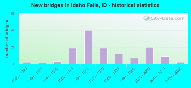
- New bridges - historical statistics
- 21920-1929
- 11930-1939
- 31940-1949
- 191950-1959
- 401960-1969
- 191970-1979
- 121980-1989
- 71990-1999
- 202000-2009
- 92010-2019
- 22020-2022
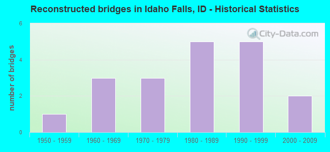
- Reconstructed bridges - Historical Statistics
- 11950-1959
- 31960-1969
- 31970-1979
- 51980-1989
- 51990-1999
- 22000-2009
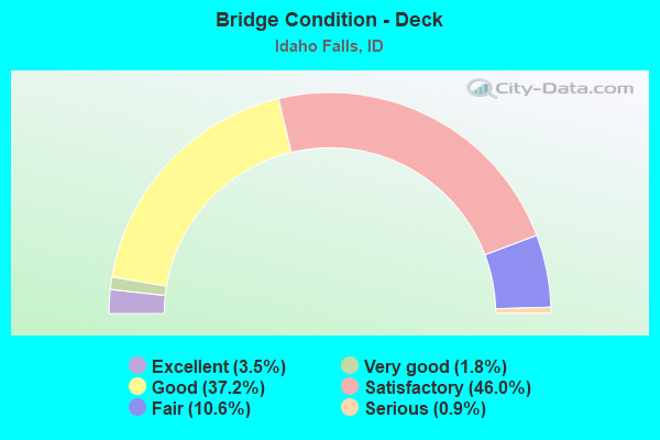
- Bridge Condition - Deck
- 3.5%Excellent
- 1.8%Very good
- 37.2%Good
- 46.0%Satisfactory
- 10.6%Fair
- 0.9%Serious
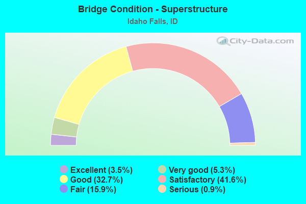
- Bridge Condition - Superstructure
- 3.5%Excellent
- 5.3%Very good
- 32.7%Good
- 41.6%Satisfactory
- 15.9%Fair
- 0.9%Serious
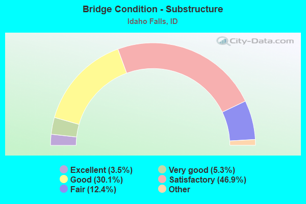
- Bridge Condition - Substructure
- 3.5%Excellent
- 5.3%Very good
- 30.1%Good
- 46.9%Satisfactory
- 12.4%Fair
- 1.8%Poor
- 0.9%Serious
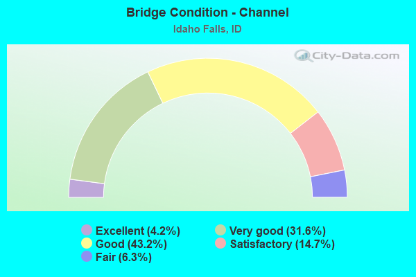
- Bridge Condition - Channel
- 4.2%Excellent
- 31.6%Very good
- 43.2%Good
- 14.7%Satisfactory
- 6.3%Fair
Find on map >> Show street view
Structure Number: 1169, Location: 2.7 S. IDAHO FALLS (Lat: 43.466878, Lng: -112.087053), Route carried "on" structure: Interstate 15, Year Built: 1962, Status: Open, Structure Length: 0.98m (3.22ft), Average Daily Traffic: 14,000 (year 2019), Truck Traffic: 15%, Average Future Daily Traffic: 21,000 (year 2039), Design Load: HS 20, Features Intersected: SIDEHILL CANAL
Minimum Vertical Clearance: 30+ m (98+ ft), Kilometerpoint: 186.389, Lanes on structure: 2, Base Highway Network: Yes, Owner: State Highway Agency, Approaching Roadway Width: 11.9m (39.0ft), Skew: 4 degrees, Material/Design: Concrete, Design/Construction: Frame, Number Of Spans In Main Unit: 1, Length of Maximum Span: 9.8m (32.2ft), Curb-To-Curb Width: 12.7m (41.7ft), Out-to-Out Width: 14.6m (47.9ft)
Condition: Deck: Good, Superstructure: Good, Substructure: Good, Channel: Very good, Operating Rating: 57.2 metric tons, Method Used To Determine Operating Rating: Load Factor (LF), Inventory Rating: 34.5 metric tons, Method Used To Determine Inventory Rating: Load Factor (LF), Structural Evaluation: Better than present minimum criteria, Deck Geometry: Better than present minimum criteria, Waterway Adequacy: Equal to present desirable criteria, Approach Roadway Alignment: Equal to present desirable criteria, Designated Inspection Frequency: Every 48 months, Inspection Date: November 2020, Deck Structure Type: Concrete Cast-file-Place, Wearing Surface/Protective System: Wearing Surface: Bituminous
Find on map >> Show street view
Structure Number: 11692, Location: 1.2 W. IDAHO FALLS (Lat: 43.466844, Lng: -112.087567), Route carried "on" structure: Ramp Interstate 15, Year Built: 2007, Status: Open, Structure Length: 0.73m (2.40ft), Average Daily Traffic: 4,300 (year 2019), Average Future Daily Traffic: 6,450 (year 2039), Design Load: HL 93, Features Intersected: SIDEHILL CANAL
Minimum Vertical Clearance: 30+ m (98+ ft), Kilometerpoint: 16.209, Lanes on structure: 1, Owner: State Highway Agency, Approaching Roadway Width: 11.0m (36.1ft), Skew: 3 degrees, Material/Design: Concrete, Design/Construction: Frame, Number Of Spans In Main Unit: 1, Length of Maximum Span: 7.3m (24.0ft), Curb-To-Curb Width: 14.0m (45.9ft), Out-to-Out Width: 54.3m (178.1ft)
Condition: Deck: Good, Superstructure: Good, Substructure: Very good, Channel: Very good, Inventory Rating: 91.6 metric tons, Method Used To Determine Inventory Rating: Load Factor (LF), Structural Evaluation: Better than present minimum criteria, Deck Geometry: Superior to present desirable criteria, Waterway Adequacy: Equal to present desirable criteria, Approach Roadway Alignment: Equal to present desirable criteria, Designated Inspection Frequency: Every 48 months, Inspection Date: November 2020, Deck Structure Type: Concrete Precast Panels, Wearing Surface/Protective System: Wearing Surface: Bituminous
Find on map >> Show street view
Structure Number: 11695, Location: 2.7 S. IDAHO FALLS (Lat: 43.466811, Lng: -112.086636), Route carried "on" structure: Interstate 15, Year Built: 1962, Status: Open, Structure Length: 0.98m (3.22ft), Average Daily Traffic: 14,000 (year 2019), Truck Traffic: 15%, Average Future Daily Traffic: 21,000 (year 2039), Design Load: HS 20, Features Intersected: SIDEHILL CANAL
Minimum Vertical Clearance: 30+ m (98+ ft), Kilometerpoint: 186.391, Lanes on structure: 2, Base Highway Network: Yes, Owner: State Highway Agency, Approaching Roadway Width: 11.9m (39.0ft), Skew: 4 degrees, Material/Design: Concrete, Design/Construction: Frame, Number Of Spans In Main Unit: 1, Length of Maximum Span: 9.8m (32.2ft), Curb-To-Curb Width: 12.4m (40.7ft), Out-to-Out Width: 14.6m (47.9ft)
Condition: Deck: Good, Superstructure: Good, Substructure: Good, Channel: Very good, Operating Rating: 57.2 metric tons, Method Used To Determine Operating Rating: Load Factor (LF), Inventory Rating: 34.5 metric tons, Method Used To Determine Inventory Rating: Load Factor (LF), Structural Evaluation: Better than present minimum criteria, Deck Geometry: Better than present minimum criteria, Waterway Adequacy: Equal to present desirable criteria, Approach Roadway Alignment: Equal to present desirable criteria, Designated Inspection Frequency: Every 48 months, Inspection Date: November 2020, Deck Structure Type: Concrete Cast-file-Place, Wearing Surface/Protective System: Wearing Surface: Bituminous
Find on map >> Show street view
Structure Number: 11697, Location: 1.0 W. IDAHO FALLS (Lat: 43.466742, Lng: -112.085167), Route carried "on" structure: Ramp Interstate 15, Year Built: 2007, Status: Open, Structure Length: 0.73m (2.40ft), Average Daily Traffic: 4,100 (year 2019), Average Future Daily Traffic: 6,150 (year 2039), Design Load: HL 93, Features Intersected: SIDEHILL CANAL
Minimum Vertical Clearance: 30+ m (98+ ft), Kilometerpoint: 16.531, Lanes on structure: 1, Owner: State Highway Agency, Approaching Roadway Width: 11.3m (37.1ft), Skew: 3 degrees, Material/Design: Concrete, Design/Construction: Frame, Number Of Spans In Main Unit: 1, Length of Maximum Span: 7.3m (24.0ft), Curb-To-Curb Width: 13.1m (43.0ft), Out-to-Out Width: 36.0m (118.1ft)
Condition: Deck: Good, Superstructure: Good, Substructure: Good, Channel: Very good, Structural Evaluation: Better than present minimum criteria, Deck Geometry: Superior to present desirable criteria, Waterway Adequacy: Equal to present desirable criteria, Approach Roadway Alignment: Equal to present desirable criteria, Designated Inspection Frequency: Every 48 months, Inspection Date: November 2020, Deck Structure Type: Concrete Precast Panels, Wearing Surface/Protective System: Wearing Surface: Bituminous
Find on map >> Show street view
Structure Number: 11705, Location: 2.0 S. IDAHO FALLS (Lat: 43.474450, Lng: -112.077408), Route carried "on" structure: Interstate 15, Year Built: 1962, Status: Open, Structure Length: 0.79m (2.59ft), Average Daily Traffic: 11,500 (year 2019), Truck Traffic: 19%, Average Future Daily Traffic: 17,250 (year 2039), Design Load: HS 20, Features Intersected: PORTER CANAL
Minimum Vertical Clearance: 30+ m (98+ ft), Kilometerpoint: 187.489, Lanes on structure: 2, Base Highway Network: Yes, Owner: State Highway Agency, Approaching Roadway Width: 12.5m (41.0ft), Skew: 3 degrees, Material/Design: Concrete, Design/Construction: Frame, Number Of Spans In Main Unit: 1, Length of Maximum Span: 7.9m (25.9ft), Curb-To-Curb Width: 12.5m (41.0ft), Out-to-Out Width: 14.6m (47.9ft)
Condition: Deck: Good, Superstructure: Good, Substructure: Satisfactory, Channel: Good, Operating Rating: 59.0 metric tons, Method Used To Determine Operating Rating: Load Factor (LF), Inventory Rating: 35.4 metric tons, Method Used To Determine Inventory Rating: Load Factor (LF), Structural Evaluation: Equal to present minimum criteria, Deck Geometry: Better than present minimum criteria, Waterway Adequacy: Equal to present desirable criteria, Approach Roadway Alignment: Equal to present desirable criteria, Designated Inspection Frequency: Every 48 months, Inspection Date: November 2020, Deck Structure Type: Concrete Cast-file-Place, Wearing Surface/Protective System: Wearing Surface: Bituminous
Find on map >> Show street view
Structure Number: 11725, Location: IN IDAHO FALLS;BROADWAY (Lat: 43.496889, Lng: -112.053944), Route carried "on" structure: Interstate 15, Year Built: 1962, Status: Open, Structure Length: 5.33m (17.49ft), Average Daily Traffic: 11,500 (year 2019), Truck Traffic: 19%, Average Future Daily Traffic: 17,250 (year 2039), Design Load: HS 20, Features Intersected: I 15B;BROADWAY ST.IC
Minimum Vertical Clearance: 30+ m (98+ ft), Kilometerpoint: 190.760, Lanes on structure: 3, Lanes under structure: 5, Base Highway Network: Yes, Owner: State Highway Agency, Approaching Roadway Width: 14.0m (45.9ft), Skew: 1 degrees, Material/Design: Concrete, Design/Construction: Tee Beam, Number Of Spans In Main Unit: 4, Length of Maximum Span: 15.9m (52.2ft), Curb-To-Curb Width: 14.1m (46.3ft), Out-to-Out Width: 14.6m (47.9ft)
Condition: Deck: Good, Superstructure: Satisfactory, Substructure: Satisfactory, Operating Rating: 40.8 metric tons, Method Used To Determine Operating Rating: Load Factor (LF), Inventory Rating: 24.5 metric tons, Method Used To Determine Inventory Rating: Load Factor (LF), Structural Evaluation: Equal to present minimum criteria, Deck Geometry: Meets minimum limits, Underclear: High priority of replacement, Approach Roadway Alignment: Equal to present minimum criteria, Length Of Structure Improvement: 6.40m (21.00ft), Designated Inspection Frequency: Every 24 months, Inspection Date: May 2021, Bridge Improvement Cost: $1,455,000, Roadway Improvement Cost: $146,000, Total Project Cost: $2,183,000 ( Estimate for 2019), Deck Structure Type: Concrete Cast-file-Place, Wearing Surface/Protective System: Wearing Surface: Epoxy Overlay
Find on map >> Show street view
Structure Number: 1174, Location: 4.1 N. IDAHO FALLS (Lat: 43.552433, Lng: -112.072478), Route carried "on" structure: Interstate 15, Year Built: 1962, Status: Open, Structure Length: 2.44m (8.01ft), Average Daily Traffic: 3,200 (year 2019), Truck Traffic: 25%, Average Future Daily Traffic: 4,800 (year 2039), Design Load: HS 20, Features Intersected: GREAT WESTERN CANAL
Minimum Vertical Clearance: 30+ m (98+ ft), Kilometerpoint: 197.231, Lanes on structure: 2, Base Highway Network: Yes, Owner: State Highway Agency, Approaching Roadway Width: 11.6m (38.1ft), Skew: 3 degrees, Material/Design: Concrete, Design/Construction: Stringer/Multi-beam, Number Of Spans In Main Unit: 2, Length of Maximum Span: 11.9m (39.0ft), Curb-To-Curb Width: 11.6m (38.1ft), Out-to-Out Width: 12.2m (40.0ft)
Condition: Deck: Good, Superstructure: Good, Substructure: Satisfactory, Channel: Good, Operating Rating: 54.4 metric tons, Method Used To Determine Operating Rating: Load Factor (LF), Inventory Rating: 32.7 metric tons, Method Used To Determine Inventory Rating: Load Factor (LF), Structural Evaluation: Equal to present minimum criteria, Deck Geometry: Equal to present minimum criteria, Waterway Adequacy: Better than present minimum criteria, Approach Roadway Alignment: Equal to present desirable criteria, Designated Inspection Frequency: Every 48 months, Inspection Date: November 2020, Deck Structure Type: Concrete Cast-file-Place, Wearing Surface/Protective System: Wearing Surface: Epoxy Overlay
Find on map >> Show street view
Structure Number: 11745, Location: 4.1 N. IDAHO FALLS (Lat: 43.552431, Lng: -112.072078), Route carried "on" structure: Interstate 15, Year Built: 1962, Status: Open, Structure Length: 2.44m (8.01ft), Average Daily Traffic: 3,200 (year 2019), Truck Traffic: 25%, Average Future Daily Traffic: 4,800 (year 2039), Design Load: HS 20, Features Intersected: GREAT WESTERN CANAL
Minimum Vertical Clearance: 30+ m (98+ ft), Kilometerpoint: 197.233, Lanes on structure: 2, Base Highway Network: Yes, Owner: State Highway Agency, Approaching Roadway Width: 11.6m (38.1ft), Skew: 3 degrees, Material/Design: Concrete, Design/Construction: Stringer/Multi-beam, Number Of Spans In Main Unit: 2, Length of Maximum Span: 11.9m (39.0ft), Curb-To-Curb Width: 11.6m (38.1ft), Out-to-Out Width: 12.2m (40.0ft)
Condition: Deck: Good, Superstructure: Satisfactory, Substructure: Satisfactory, Channel: Good, Operating Rating: 53.5 metric tons, Method Used To Determine Operating Rating: Load Factor (LF), Inventory Rating: 32.7 metric tons, Method Used To Determine Inventory Rating: Load Factor (LF), Structural Evaluation: Equal to present minimum criteria, Deck Geometry: Equal to present minimum criteria, Waterway Adequacy: Better than present minimum criteria, Approach Roadway Alignment: Equal to present desirable criteria, Designated Inspection Frequency: Every 48 months, Inspection Date: November 2020, Deck Structure Type: Concrete Cast-file-Place, Wearing Surface/Protective System: Wearing Surface: Epoxy Overlay
Find on map >> Show street view
Structure Number: 12096, Location: 3.0 N. SHELLEY (Lat: 43.439267, Lng: -112.121186), Route carried "on" structure: County highway 6710, Year Built: 1996, Status: Open, Structure Length: 7.47m (24.51ft), Average Daily Traffic: 5,600 (year 2019), Truck Traffic: 14%, Average Future Daily Traffic: 8,400 (year 2039), Design Load: HS 25 or greater, Features Intersected: I 15 SB-NB;N. SHELLEY IC
Minimum Vertical Clearance: 30+ m (98+ ft), Kilometerpoint: 1.736, Lanes on structure: 2, Lanes under structure: 4, Owner: State Highway Agency, Approaching Roadway Width: 15.2m (49.9ft), Material/Design: Prestressed concrete continuous, Design/Construction: Box Beam or Girders - Multiple, Number Of Spans In Main Unit: 4, Length of Maximum Span: 24.4m (80.1ft), Curb-To-Curb Width: 15.4m (50.5ft), Out-to-Out Width: 16.2m (53.1ft)
Condition: Deck: Good, Superstructure: Good, Substructure: Good, Operating Rating: 95.3 metric tons, Method Used To Determine Operating Rating: Load Factor (LF), Inventory Rating: 43.5 metric tons, Method Used To Determine Inventory Rating: Load Factor (LF), Structural Evaluation: Better than present minimum criteria, Deck Geometry: Superior to present desirable criteria, Underclear: Meets minimum limits, Approach Roadway Alignment: Equal to present desirable criteria, Designated Inspection Frequency: Every 48 months, Inspection Date: May 2020, Deck Structure Type: Concrete Cast-file-Place, Wearing Surface/Protective System: Wearing Surface: Epoxy Overlay, Deck Protection: Epoxy Coated Reinforcing
Find on map >> Show street view
Structure Number: 121, Location: 2.9 S. IDAHO FALLS SCL (Lat: 43.439528, Lng: -112.099472), Route carried "on" structure: County highway 6710, Year Built: 1963, Year Reconstructed: 1979, Status: Open, Structure Length: 24.75m (81.20ft), Average Daily Traffic: 5,700 (year 2019), Truck Traffic: 26%, Average Future Daily Traffic: 8,550 (year 2039), Design Load: HS 20, Features Intersected: SNAKE RIVER
Minimum Vertical Clearance: 30+ m (98+ ft), Kilometerpoint: 2.062, Lanes on structure: 2, Base Highway Network: Yes, Owner: County Highway Agency, Approaching Roadway Width: 8.5m (27.9ft), Material/Design: Steel, Design/Construction: Stringer/Multi-beam, Number Of Spans In Main Unit: 9, Length of Maximum Span: 36.3m (119.1ft), Curb-To-Curb Width: 9.2m (30.2ft), Out-to-Out Width: 10.0m (32.8ft)
Condition: Deck: Fair, Superstructure: Satisfactory, Substructure: Fair, Channel: Fair, Operating Rating: 63.5 metric tons, Method Used To Determine Operating Rating: Load Factor (LF), Inventory Rating: 37.2 metric tons, Method Used To Determine Inventory Rating: Load Factor (LF), Structural Evaluation: Somewhat better than minimum adequacy, Deck Geometry: Meets minimum limits, Waterway Adequacy: Equal to present desirable criteria, Approach Roadway Alignment: Equal to present desirable criteria, Length Of Structure Improvement: 24.99m (81.99ft), Designated Inspection Frequency: Every 24 months, Underwater Inspection Frequency: Every 60 months, Other Special Inspection Frequency: Every 48 months, Inspection Date: July 2021, Underwater Inspection Date: October 2018, Other Special Inspection Date: July 2019, Bridge Improvement Cost: $6,494,000, Roadway Improvement Cost: $649,000, Total Project Cost: $9,742,000 ( Estimate for 2017), Deck Structure Type: Concrete Cast-file-Place, Wearing Surface/Protective System: Wearing Surface: Bituminous, Deck Protection: Epoxy Coated Reinforcing
Find on map >> Show street view
Structure Number: 12105, Location: IN IDAHO FALLS (Lat: 43.493139, Lng: -112.044917), Route carried "on" structure: Business Interstate 15, Year Built: 1981, Status: Open, Structure Length: 8.75m (28.71ft), Average Daily Traffic: 22,000 (year 2019), Truck Traffic: 5%, Average Future Daily Traffic: 33,000 (year 2039), Design Load: HS 20, Features Intersected: SNAKE RIVER;BROADWAY ST.
Minimum Vertical Clearance: 30+ m (98+ ft), Kilometerpoint: 10.604, Lanes on structure: 6, Base Highway Network: Yes (Inventory Route: IB0, Subroute: 6), Owner: State Highway Agency, Approaching Roadway Width: 25.3m (83.0ft), Skew: 1 degrees, Material/Design: Steel, Design/Construction: Stringer/Multi-beam, Number Of Spans In Main Unit: 1, Number Of Approach Spans: 2, Length of Maximum Span: 47.0m (154.2ft), Curb or Sidewalk Widths: Left: 3.0m (9.8ft), Right: 2.4m (7.9ft), Curb-To-Curb Width: 26.2m (86.0ft), Out-to-Out Width: 32.5m (106.6ft)
Condition: Deck: Satisfactory, Superstructure: Fair, Substructure: Satisfactory, Channel: Very good, Operating Rating: 63.5 metric tons, Method Used To Determine Operating Rating: Load Factor (LF), Inventory Rating: 24.5 metric tons, Method Used To Determine Inventory Rating: Load Factor (LF), Structural Evaluation: Somewhat better than minimum adequacy, Deck Geometry: Equal to present minimum criteria, Waterway Adequacy: Superior to present desirable criteria, Approach Roadway Alignment: Equal to present desirable criteria, Length Of Structure Improvement: 9.63m (31.59ft), Designated Inspection Frequency: Every 24 months, Underwater Inspection Frequency: Every 60 months, Inspection Date: November 2021, Underwater Inspection Date: October 2018, Bridge Improvement Cost: $5,570,000, Roadway Improvement Cost: $558,000, Total Project Cost: $83,555,000 ( Estimate for 2017), Deck Structure Type: Concrete Cast-file-Place, Wearing Surface/Protective System: Wearing Surface: Bituminous, Membrane: Preformed Fabric, Deck Protection: Epoxy Coated Reinforcing
Find on map >> Show street view
Structure Number: 1211, Location: IN IDAHO FALLS;BROADWAY (Lat: 43.493889, Lng: -112.046611), Route carried "on" structure: Business Interstate 15, Year Built: 1987, Status: Open, Structure Length: 0.73m (2.40ft), Average Daily Traffic: 21,000 (year 2019), Truck Traffic: 5%, Average Future Daily Traffic: 31,500 (year 2039), Design Load: HS 25 or greater, Features Intersected: PORTER CANAL
Minimum Vertical Clearance: 30+ m (98+ ft), Kilometerpoint: 10.866, Lanes on structure: 7, Base Highway Network: Yes (Inventory Route: IB0, Subroute: 6), Owner: State Highway Agency, Approaching Roadway Width: 26.8m (87.9ft), Material/Design: Concrete, Design/Construction: Frame, Number Of Spans In Main Unit: 1, Length of Maximum Span: 7.3m (24.0ft), Curb or Sidewalk Widths: Left: 2.0m (6.6ft), Right: 2.3m (7.5ft), Curb-To-Curb Width: 26.8m (87.9ft), Out-to-Out Width: 31.7m (104.0ft)
Condition: Deck: Satisfactory, Superstructure: Satisfactory, Substructure: Fair, Channel: Good, Inventory Rating: 63.5 metric tons, Method Used To Determine Inventory Rating: Load Factor (LF), Structural Evaluation: Somewhat better than minimum adequacy, Deck Geometry: Somewhat better than minimum adequacy, Waterway Adequacy: Equal to present desirable criteria, Approach Roadway Alignment: Equal to present desirable criteria, Length Of Structure Improvement: 1.37m (4.49ft), Designated Inspection Frequency: Every 24 months, Inspection Date: March 2021, Bridge Improvement Cost: $772,000, Roadway Improvement Cost: $77,000, Total Project Cost: $1,158,000 ( Estimate for 2019), Deck Structure Type: Concrete Cast-file-Place, Wearing Surface/Protective System: Wearing Surface: Bituminous, Membrane: Built-up
Find on map >> Show street view
Structure Number: 12295, Location: 4.8 W. IDAHO FALLS (Lat: 43.497028, Lng: -112.137861), Route carried "on" structure: US 20, Year Built: 1976, Year Reconstructed: 1996, Status: Open, Structure Length: 0.67m (2.20ft), Average Daily Traffic: 3,900 (year 2019), Truck Traffic: 6%, Average Future Daily Traffic: 5,850 (year 2039), Design Load: HS 20, Features Intersected: OAKLAND WASTE DITCH
Minimum Vertical Clearance: 30+ m (98+ ft), Kilometerpoint: 487.241, Lanes on structure: 5, Base Highway Network: Yes (Inventory Route: US0, Subroute: 1), Owner: State Highway Agency, Approaching Roadway Width: 22.9m (75.1ft), Skew: 1 degrees, Material/Design: Steel, Design/Construction: Culvert, Number Of Spans In Main Unit: 1, Length of Maximum Span: 6.7m (22.0ft), Out-to-Out Width: 63.1m (207.0ft)
Condition: Channel: Satisfactory, Culverts: Good, Structural Evaluation: Better than present minimum criteria, Waterway Adequacy: Equal to present desirable criteria, Approach Roadway Alignment: Equal to present desirable criteria, Length Of Structure Improvement: 1.52m (4.99ft), Designated Inspection Frequency: Every 48 months, Inspection Date: November 2020, Bridge Improvement Cost: $396,000, Roadway Improvement Cost: $40,000, Total Project Cost: $594,000 ( Estimate for 2020)
Find on map >> Show street view
Structure Number: 1231, Location: IN IDAHO FALLS (Lat: 43.504250, Lng: -112.056306), Route carried "on" structure: US 20, Year Built: 1962, Year Reconstructed: 1992, Status: Open, Structure Length: 5.97m (19.59ft), Average Daily Traffic: 21,000 (year 2019), Truck Traffic: 7%, Average Future Daily Traffic: 31,500 (year 2039), Design Load: HS 20, Features Intersected: I 15 NB-SB;JOHNS HOLE IC
Minimum Vertical Clearance: 30+ m (98+ ft), Kilometerpoint: 494.962, Lanes on structure: 5, Lanes under structure: 4, Base Highway Network: Yes (Inventory Route: US0, Subroute: 1), Owner: State Highway Agency, Approaching Roadway Width: 19.8m (65.0ft), Material/Design: Prestressed concrete, Design/Construction: Tee Beam, Number Of Spans In Main Unit: 4, Length of Maximum Span: 19.2m (63.0ft), Curb or Sidewalk Widths: Left: 0.0m, Right: 1.7m (5.6ft), Curb-To-Curb Width: 18.5m (60.7ft), Out-to-Out Width: 20.9m (68.6ft)
Condition: Deck: Good, Superstructure: Good, Substructure: Good, Operating Rating: 63.5 metric tons, Method Used To Determine Operating Rating: Load Factor (LF), Inventory Rating: 31.8 metric tons, Method Used To Determine Inventory Rating: Load Factor (LF), Structural Evaluation: Better than present minimum criteria, Deck Geometry: High priority of corrective action, Underclear: High priority of corrective action, Approach Roadway Alignment: Equal to present desirable criteria, Designated Inspection Frequency: Every 48 months, Inspection Date: May 2020, Deck Structure Type: Concrete Cast-file-Place, Wearing Surface/Protective System: Wearing Surface: Epoxy Overlay
Find on map >> Show street view
Structure Number: 12315, Location: IN IDAHO FALLS (Lat: 43.504544, Lng: -112.054469), Route carried "on" structure: US 20, Year Built: 1966, Year Reconstructed: 1990, Status: Open, Structure Length: 4.42m (14.50ft), Average Daily Traffic: 28,000 (year 2019), Truck Traffic: 9%, Average Future Daily Traffic: 42,000 (year 2039), Design Load: HS 20, Features Intersected: EASTERN IDAHO RAILROAD
Minimum Vertical Clearance: 30+ m (98+ ft), Kilometerpoint: 495.115, Lanes on structure: 4, Base Highway Network: Yes (Inventory Route: US0, Subroute: 1), Owner: State Highway Agency, Approaching Roadway Width: 17.1m (56.1ft), Skew: 20 degrees, Material/Design: Steel, Design/Construction: Stringer/Multi-beam, Number Of Spans In Main Unit: 3, Length of Maximum Span: 16.8m (55.1ft), Curb or Sidewalk Widths: Left: 1.4m (4.6ft), Right: 1.4m (4.6ft), Curb-To-Curb Width: 17.1m (56.1ft), Out-to-Out Width: 20.3m (66.6ft)
Condition: Deck: Satisfactory, Superstructure: Satisfactory, Substructure: Satisfactory, Operating Rating: 55.3 metric tons, Method Used To Determine Operating Rating: Load Factor (LF), Inventory Rating: 33.6 metric tons, Method Used To Determine Inventory Rating: Load Factor (LF), Structural Evaluation: Equal to present minimum criteria, Deck Geometry: Somewhat better than minimum adequacy, Underclear: Somewhat better than minimum adequacy, Approach Roadway Alignment: Equal to present desirable criteria, Designated Inspection Frequency: Every 48 months, Other Special Inspection Frequency: Every 48 months, Inspection Date: May 2021, Other Special Inspection Date: May 2021, Deck Structure Type: Concrete Cast-file-Place, Wearing Surface/Protective System: Wearing Surface: Latex Concrete, Deck Protection: Epoxy Coated Reinforcing
Find on map >> Show street view
Structure Number: 1232, Location: IN IDAHO FALLS;LINDSAY BL (Lat: 43.504778, Lng: -112.053694), Route carried "on" structure: US 20, Year Built: 1966, Year Reconstructed: 1989, Status: Open, Structure Length: 3.57m (11.71ft), Average Daily Traffic: 28,000 (year 2019), Truck Traffic: 9%, Average Future Daily Traffic: 42,000 (year 2039), Design Load: HS 20, Features Intersected: SMA 7076;LINDSAY BLVD.IC
Minimum Vertical Clearance: 30+ m (98+ ft), Kilometerpoint: 495.179, Lanes on structure: 4, Lanes under structure: 2, Base Highway Network: Yes (Inventory Route: US0, Subroute: 1), Owner: State Highway Agency, Approaching Roadway Width: 17.7m (58.1ft), Skew: 21 degrees, Material/Design: Prestressed concrete, Design/Construction: Stringer/Multi-beam, Number Of Spans In Main Unit: 3, Length of Maximum Span: 11.6m (38.1ft), Curb or Sidewalk Widths: Left: 1.4m (4.6ft), Right: 1.4m (4.6ft), Curb-To-Curb Width: 17.1m (56.1ft), Out-to-Out Width: 20.3m (66.6ft)
Condition: Deck: Satisfactory, Superstructure: Satisfactory, Substructure: Satisfactory, Operating Rating: 52.6 metric tons, Method Used To Determine Operating Rating: Load Factor (LF), Inventory Rating: 29.0 metric tons, Method Used To Determine Inventory Rating: Load Factor (LF), Structural Evaluation: Equal to present minimum criteria, Deck Geometry: Somewhat better than minimum adequacy, Underclear: High priority of corrective action, Approach Roadway Alignment: Equal to present desirable criteria, Designated Inspection Frequency: Every 24 months, Inspection Date: May 2021, Deck Structure Type: Concrete Cast-file-Place, Wearing Surface/Protective System: Wearing Surface: Integral Concrete, Deck Protection: Epoxy Coated Reinforcing
Find on map >> Show street view
Structure Number: 1233, Location: IN IDAHO FALLS (Lat: 43.505833, Lng: -112.051583), Route carried "on" structure: US 20, Year Built: 1966, Year Reconstructed: 1990, Status: Open, Structure Length: 1.07m (3.51ft), Average Daily Traffic: 35,000 (year 2019), Truck Traffic: 16%, Average Future Daily Traffic: 52,500 (year 2039), Design Load: HS 20, Features Intersected: PORTER CANAL
Minimum Vertical Clearance: 30+ m (98+ ft), Kilometerpoint: 495.383, Lanes on structure: 6, Base Highway Network: Yes (Inventory Route: US0, Subroute: 1), Owner: State Highway Agency, Approaching Roadway Width: 28.3m (92.8ft), Skew: 21 degrees, Material/Design: Concrete, Design/Construction: Frame, Number Of Spans In Main Unit: 1, Length of Maximum Span: 10.7m (35.1ft), Curb or Sidewalk Widths: Left: 0.0m, Right: 1.6m (5.2ft), Curb-To-Curb Width: 28.3m (92.8ft), Out-to-Out Width: 40.8m (133.9ft)
Condition: Deck: Good, Superstructure: Good, Substructure: Satisfactory, Channel: Good, Operating Rating: 62.6 metric tons, Method Used To Determine Operating Rating: Load Factor (LF), Inventory Rating: 37.2 metric tons, Method Used To Determine Inventory Rating: Load Factor (LF), Structural Evaluation: Equal to present minimum criteria, Deck Geometry: Superior to present desirable criteria, Waterway Adequacy: Equal to present desirable criteria, Approach Roadway Alignment: Equal to present desirable criteria, Designated Inspection Frequency: Every 48 months, Inspection Date: November 2019, Deck Structure Type: Concrete Cast-file-Place, Wearing Surface/Protective System: Wearing Surface: Bituminous, Membrane: Preformed Fabric
Find on map >> Show street view
Structure Number: 12335, Location: IN IDAHO FALLS (Lat: 43.506500, Lng: -112.050444), Route carried "on" structure: US 20, Year Built: 1966, Year Reconstructed: 1991, Status: Open, Structure Length: 5.46m (17.91ft), Average Daily Traffic: 35,000 (year 2019), Truck Traffic: 16%, Average Future Daily Traffic: 52,500 (year 2039), Design Load: HS 20, Features Intersected: SNAKE R.;JOHN'S HOLE BR.
Minimum Vertical Clearance: 30+ m (98+ ft), Kilometerpoint: 495.507, Lanes on structure: 6, Base Highway Network: Yes (Inventory Route: US0, Subroute: 1), Owner: State Highway Agency, Approaching Roadway Width: 24.4m (80.1ft), Skew: 22 degrees, Material/Design: Steel, Design/Construction: Stringer/Multi-beam, Number Of Spans In Main Unit: 1, Length of Maximum Span: 53.3m (174.9ft), Curb or Sidewalk Widths: Left: 0.0m, Right: 2.4m (7.9ft), Curb-To-Curb Width: 24.6m (80.7ft), Out-to-Out Width: 27.9m (91.5ft)
Condition: Deck: Good, Superstructure: Satisfactory, Substructure: Satisfactory, Channel: Good, Operating Rating: 65.3 metric tons, Method Used To Determine Operating Rating: Load Factor (LF), Inventory Rating: 39.0 metric tons, Method Used To Determine Inventory Rating: Load Factor (LF), Structural Evaluation: Equal to present minimum criteria, Deck Geometry: Somewhat better than minimum adequacy, Waterway Adequacy: Equal to present desirable criteria, Approach Roadway Alignment: Equal to present desirable criteria, Designated Inspection Frequency: Every 48 months, Other Special Inspection Frequency: Every 48 months, Inspection Date: May 2021, Other Special Inspection Date: May 2021, Deck Structure Type: Concrete Cast-file-Place, Wearing Surface/Protective System: Wearing Surface: Epoxy Overlay, Deck Protection: Epoxy Coated Reinforcing
Find on map >> Show street view
Structure Number: 1234, Location: IN IDAHO FALLS;RIVERSIDE (Lat: 43.508500, Lng: -112.047167), Route carried "on" structure: US 20, Year Built: 1969, Year Reconstructed: 1989, Status: Open, Structure Length: 4.88m (16.01ft), Average Daily Traffic: 30,000 (year 2019), Truck Traffic: 12%, Average Future Daily Traffic: 45,000 (year 2039), Design Load: HS 20, Features Intersected: SMA 7096;RIVERSIDE DR.IC
Minimum Vertical Clearance: 30+ m (98+ ft), Kilometerpoint: 495.870, Lanes on structure: 4, Lanes under structure: 5, Base Highway Network: Yes (Inventory Route: US0, Subroute: 1), Owner: State Highway Agency, Approaching Roadway Width: 24.4m (80.1ft), Skew: 23 degrees, Material/Design: Steel continuous, Design/Construction: Stringer/Multi-beam, Number Of Spans In Main Unit: 2, Length of Maximum Span: 28.7m (94.2ft), Curb-To-Curb Width: 23.3m (76.4ft), Out-to-Out Width: 24.2m (79.4ft)
Condition: Deck: Satisfactory, Superstructure: Fair, Substructure: Satisfactory, Operating Rating: 56.2 metric tons, Method Used To Determine Operating Rating: Load Factor (LF), Inventory Rating: 33.6 metric tons, Method Used To Determine Inventory Rating: Load Factor (LF), Structural Evaluation: Somewhat better than minimum adequacy, Deck Geometry: Superior to present desirable criteria, Underclear: Meets minimum limits, Approach Roadway Alignment: Equal to present desirable criteria, Length Of Structure Improvement: 5.94m (19.49ft), Designated Inspection Frequency: Every 24 months, Other Special Inspection Frequency: Every 48 months, Inspection Date: May 2021, Other Special Inspection Date: May 2021, Bridge Improvement Cost: $1,545,000, Roadway Improvement Cost: $155,000, Total Project Cost: $2,318,000 ( Estimate for 2017), Deck Structure Type: Concrete Cast-file-Place, Wearing Surface/Protective System: Wearing Surface: Low Slump Concrete, Deck Protection: Epoxy Coated Reinforcing
Find on map >> Show street view
Structure Number: 12345, Location: IF; SCIENCE CENTER DR (Lat: 43.514708, Lng: -112.040411), Route carried "on" structure: US 20, Year Built: 1987, Status: Open, Structure Length: 7.74m (25.39ft), Average Daily Traffic: 10,500 (year 2019), Truck Traffic: 11%, Average Future Daily Traffic: 15,750 (year 2039), Design Load: HS 25 or greater, Features Intersected: S7046;RR;SCIENCE CTR IC
Minimum Vertical Clearance: 30+ m (98+ ft), Kilometerpoint: 496.766, Lanes on structure: 2, Lanes under structure: 3, Base Highway Network: Yes (Inventory Route: US0, Subroute: 1), Owner: State Highway Agency, Approaching Roadway Width: 12.8m (42.0ft), Material/Design: Prestressed concrete, Design/Construction: Stringer/Multi-beam, Number Of Spans In Main Unit: 4, Length of Maximum Span: 23.2m (76.1ft), Curb-To-Curb Width: 12.4m (40.7ft), Out-to-Out Width: 13.3m (43.6ft)
Condition: Deck: Satisfactory, Superstructure: Fair, Substructure: Satisfactory, Operating Rating: 82.6 metric tons, Method Used To Determine Operating Rating: Load Factor (LF), Inventory Rating: 41.7 metric tons, Method Used To Determine Inventory Rating: Load Factor (LF), Structural Evaluation: Somewhat better than minimum adequacy, Deck Geometry: Better than present minimum criteria, Underclear: Meets minimum limits, Approach Roadway Alignment: Equal to present desirable criteria, Designated Inspection Frequency: Every 24 months, Inspection Date: May 2020, Deck Structure Type: Concrete Cast-file-Place, Wearing Surface/Protective System: Wearing Surface: Bituminous, Deck Protection: Epoxy Coated Reinforcing
Find on map >> Show street view
Structure Number: 1235, Location: IF; SCIENCE CENTER DR (Lat: 43.515400, Lng: -112.040092), Route carried "on" structure: US 20, Year Built: 1970, Status: Open, Structure Length: 7.74m (25.39ft), Average Daily Traffic: 10,500 (year 2019), Truck Traffic: 11%, Average Future Daily Traffic: 15,750 (year 2039), Design Load: HS 20, Features Intersected: S7046;RR;SCIENCE CTR IC
Minimum Vertical Clearance: 30+ m (98+ ft), Kilometerpoint: 496.768, Lanes on structure: 2, Lanes under structure: 3, Base Highway Network: Yes (Inventory Route: US0, Subroute: 1), Owner: State Highway Agency, Approaching Roadway Width: 12.8m (42.0ft), Material/Design: Prestressed concrete, Design/Construction: Stringer/Multi-beam, Number Of Spans In Main Unit: 4, Length of Maximum Span: 22.9m (75.1ft), Curb-To-Curb Width: 12.4m (40.7ft), Out-to-Out Width: 13.3m (43.6ft)
Condition: Deck: Satisfactory, Superstructure: Fair, Substructure: Satisfactory, Operating Rating: 74.4 metric tons, Method Used To Determine Operating Rating: Load Factor (LF), Inventory Rating: 38.1 metric tons, Method Used To Determine Inventory Rating: Load Factor (LF), Structural Evaluation: Somewhat better than minimum adequacy, Deck Geometry: Better than present minimum criteria, Underclear: Meets minimum limits, Approach Roadway Alignment: Equal to present desirable criteria, Designated Inspection Frequency: Every 24 months, Inspection Date: May 2020, Deck Structure Type: Concrete Cast-file-Place, Wearing Surface/Protective System: Wearing Surface: Latex Concrete
Find on map >> Show street view
Structure Number: 12355, Location: ID FALLS;LEWISVILLE HWY (Lat: 43.526811, Lng: -112.023950), Route carried "on" structure: US 20, Year Built: 1987, Status: Open, Structure Length: 5.70m (18.70ft), Average Daily Traffic: 10,500 (year 2019), Truck Traffic: 11%, Average Future Daily Traffic: 15,750 (year 2039), Design Load: HS 25 or greater, Features Intersected: US 20B;LEWISVILLE RD IC
Minimum Vertical Clearance: 30+ m (98+ ft), Kilometerpoint: 498.660, Lanes on structure: 2, Lanes under structure: 4, Base Highway Network: Yes (Inventory Route: US0, Subroute: 1), Owner: State Highway Agency, Approaching Roadway Width: 12.8m (42.0ft), Skew: 3 degrees, Material/Design: Prestressed concrete continuous, Design/Construction: Stringer/Multi-beam, Number Of Spans In Main Unit: 3, Length of Maximum Span: 32.9m (107.9ft), Curb-To-Curb Width: 12.4m (40.7ft), Out-to-Out Width: 13.3m (43.6ft)
Condition: Deck: Good, Superstructure: Good, Substructure: Good, Inventory Rating: 43.5 metric tons, Method Used To Determine Inventory Rating: Load Factor (LF), Structural Evaluation: Better than present minimum criteria, Deck Geometry: Better than present minimum criteria, Underclear: High priority of corrective action, Approach Roadway Alignment: Equal to present desirable criteria, Designated Inspection Frequency: Every 48 months, Inspection Date: May 2018, Deck Structure Type: Concrete Cast-file-Place, Wearing Surface/Protective System: Wearing Surface: Monolithic Concrete, Deck Protection: Epoxy Coated Reinforcing
Find on map >> Show street view
Structure Number: 1236, Location: ID FALLS;LEWISVILLE HWY (Lat: 43.527414, Lng: -112.023267), Route carried "on" structure: US 20, Year Built: 1987, Status: Open, Structure Length: 5.70m (18.70ft), Average Daily Traffic: 10,500 (year 2019), Truck Traffic: 11%, Average Future Daily Traffic: 15,750 (year 2039), Design Load: HS 25 or greater, Features Intersected: US 20B;LEWISVILLE RD IC
Minimum Vertical Clearance: 30+ m (98+ ft), Kilometerpoint: 498.671, Lanes on structure: 2, Lanes under structure: 4, Base Highway Network: Yes (Inventory Route: US0, Subroute: 1), Owner: State Highway Agency, Approaching Roadway Width: 12.8m (42.0ft), Skew: 3 degrees, Material/Design: Prestressed concrete continuous, Design/Construction: Stringer/Multi-beam, Number Of Spans In Main Unit: 3, Length of Maximum Span: 32.9m (107.9ft), Curb-To-Curb Width: 12.4m (40.7ft), Out-to-Out Width: 13.3m (43.6ft)
Condition: Deck: Satisfactory, Superstructure: Fair, Substructure: Good, Inventory Rating: 43.5 metric tons, Method Used To Determine Inventory Rating: Load Factor (LF), Structural Evaluation: Somewhat better than minimum adequacy, Deck Geometry: Better than present minimum criteria, Underclear: Meets minimum limits, Approach Roadway Alignment: Equal to present desirable criteria, Designated Inspection Frequency: Every 24 months, Inspection Date: May 2020, Deck Structure Type: Concrete Cast-file-Place, Wearing Surface/Protective System: Wearing Surface: Monolithic Concrete, Deck Protection: Epoxy Coated Reinforcing
Find on map >> Show street view
Structure Number: 12373, Location: 4.0 S.W. UCON (Lat: 43.543000, Lng: -112.004944), Route carried "on" structure: US 20, Year Built: 2005, Status: Open, Structure Length: 3.38m (11.09ft), Average Daily Traffic: 11,750 (year 2019), Truck Traffic: 10%, Average Future Daily Traffic: 17,625 (year 2039), Design Load: HL 93, Features Intersected: STC 6708; ST LEON RD IC
Minimum Vertical Clearance: 30+ m (98+ ft), Kilometerpoint: 501.049, Lanes on structure: 2, Lanes under structure: 2, Base Highway Network: Yes (Inventory Route: US0, Subroute: 1), Owner: State Highway Agency, Approaching Roadway Width: 12.8m (42.0ft), Skew: 2 degrees, Material/Design: Prestressed concrete, Design/Construction: Stringer/Multi-beam, Number Of Spans In Main Unit: 1, Length of Maximum Span: 33.8m (110.9ft), Curb-To-Curb Width: 12.4m (40.7ft), Out-to-Out Width: 13.2m (43.3ft)
Condition: Deck: Good, Superstructure: Very good, Substructure: Very good, Operating Rating: 93.4 metric tons, Method Used To Determine Operating Rating: Load Factor (LF), Inventory Rating: 37.2 metric tons, Method Used To Determine Inventory Rating: Load Factor (LF), Structural Evaluation: Equal to present desirable criteria, Deck Geometry: Better than present minimum criteria, Underclear: Superior to present desirable criteria, Approach Roadway Alignment: Equal to present desirable criteria, Designated Inspection Frequency: Every 48 months, Inspection Date: May 2019, Deck Structure Type: Concrete Cast-file-Place, Wearing Surface/Protective System: Wearing Surface: Epoxy Overlay, Deck Protection: Epoxy Coated Reinforcing
Find on map >> Show street view
Structure Number: 12374, Location: 4.0 S.W. UCON (Lat: 43.543417, Lng: -112.004778), Route carried "on" structure: US 20, Year Built: 2005, Status: Open, Structure Length: 3.38m (11.09ft), Average Daily Traffic: 11,750 (year 2019), Truck Traffic: 10%, Average Future Daily Traffic: 17,625 (year 2039), Design Load: HL 93, Features Intersected: STC 6708; ST LEON RD IC
Minimum Vertical Clearance: 30+ m (98+ ft), Kilometerpoint: 501.050, Lanes on structure: 2, Lanes under structure: 2, Base Highway Network: Yes (Inventory Route: US0, Subroute: 1), Owner: State Highway Agency, Approaching Roadway Width: 12.8m (42.0ft), Skew: 2 degrees, Material/Design: Prestressed concrete, Design/Construction: Stringer/Multi-beam, Number Of Spans In Main Unit: 1, Length of Maximum Span: 33.8m (110.9ft), Curb-To-Curb Width: 12.4m (40.7ft), Out-to-Out Width: 13.2m (43.3ft)
Condition: Deck: Good, Superstructure: Very good, Substructure: Very good, Operating Rating: 93.4 metric tons, Method Used To Determine Operating Rating: Load Factor (LF), Inventory Rating: 38.1 metric tons, Method Used To Determine Inventory Rating: Load Factor (LF), Structural Evaluation: Equal to present desirable criteria, Deck Geometry: Better than present minimum criteria, Underclear: Superior to present desirable criteria, Approach Roadway Alignment: Equal to present desirable criteria, Designated Inspection Frequency: Every 48 months, Inspection Date: May 2019, Deck Structure Type: Concrete Cast-file-Place, Wearing Surface/Protective System: Wearing Surface: Epoxy Overlay, Deck Protection: Epoxy Coated Reinforcing
Find on map >> Show street view
Structure Number: 12375, Location: 3 N. IDAHO FALLS (Lat: 43.547417, Lng: -111.999500), Route carried "on" structure: US 20, Year Built: 1970, Year Reconstructed: 2004, Status: Open, Structure Length: 0.67m (2.20ft), Average Daily Traffic: 23,000 (year 2019), Truck Traffic: 10%, Average Future Daily Traffic: 34,500 (year 2039), Design Load: HS 20, Features Intersected: WILLOW CREEK
Minimum Vertical Clearance: 30+ m (98+ ft), Kilometerpoint: 501.712, Lanes on structure: 4, Base Highway Network: Yes (Inventory Route: US0, Subroute: 1), Owner: State Highway Agency, Approaching Roadway Width: 23.2m (76.1ft), Skew: 12 degrees, Material/Design: Concrete, Design/Construction: Frame, Number Of Spans In Main Unit: 1, Length of Maximum Span: 6.7m (22.0ft), Curb or Sidewalk Widths: Left: 0.4m (1.3ft), Right: 0.0m, Curb-To-Curb Width: 66.8m (219.2ft), Out-to-Out Width: 66.8m (219.2ft)
Condition: Deck: Satisfactory, Superstructure: Satisfactory, Substructure: Satisfactory, Channel: Good, Operating Rating: 67.1 metric tons, Method Used To Determine Operating Rating: Load Factor (LF), Inventory Rating: 39.9 metric tons, Method Used To Determine Inventory Rating: Load Factor (LF), Structural Evaluation: Equal to present minimum criteria, Deck Geometry: Superior to present desirable criteria, Waterway Adequacy: Equal to present desirable criteria, Approach Roadway Alignment: Equal to present desirable criteria, Designated Inspection Frequency: Every 48 months, Inspection Date: April 2018, Deck Structure Type: Concrete Cast-file-Place, Wearing Surface/Protective System: Wearing Surface: Bituminous
Find on map >> Show street view
Structure Number: 13255, Location: IN IDAHO FALLS (Lat: 43.515250, Lng: -112.008778), Route carried "on" structure: US 26, Year Built: 1978, Status: Open, Structure Length: 1.62m (5.31ft), Average Daily Traffic: 12,500 (year 2019), Truck Traffic: 5%, Average Future Daily Traffic: 18,750 (year 2039), Design Load: HS 20, Features Intersected: IDAHO CANAL
Minimum Vertical Clearance: 30+ m (98+ ft), Kilometerpoint: 539.715, Lanes on structure: 5, Base Highway Network: Yes, Owner: State Highway Agency, Approaching Roadway Width: 21.3m (69.9ft), Skew: 1 degrees, Material/Design: Prestressed concrete, Design/Construction: Slab, Number Of Spans In Main Unit: 1, Length of Maximum Span: 15.8m (51.8ft), Curb or Sidewalk Widths: Left: 1.7m (5.6ft), Right: 2.6m (8.5ft), Curb-To-Curb Width: 21.3m (69.9ft), Out-to-Out Width: 26.5m (86.9ft)
Condition: Deck: Satisfactory, Superstructure: Fair, Substructure: Satisfactory, Channel: Very good, Operating Rating: 78.0 metric tons, Method Used To Determine Operating Rating: Load Factor (LF), Inventory Rating: 28.1 metric tons, Method Used To Determine Inventory Rating: Load Factor (LF), Structural Evaluation: Somewhat better than minimum adequacy, Deck Geometry: Somewhat better than minimum adequacy, Waterway Adequacy: Equal to present desirable criteria, Approach Roadway Alignment: Equal to present desirable criteria, Length Of Structure Improvement: 2.26m (7.41ft), Designated Inspection Frequency: Every 24 months, Inspection Date: March 2020, Bridge Improvement Cost: $761,000, Roadway Improvement Cost: $76,000, Total Project Cost: $1,142,000 ( Estimate for 2018), Deck Structure Type: Concrete Cast-file-Place, Wearing Surface/Protective System: Wearing Surface: Epoxy Overlay, Deck Protection: Epoxy Coated Reinforcing
Find on map >> Show street view
Structure Number: 19315, Location: 3.3 E. SHELLEY (Lat: 43.381250, Lng: -112.058139), Route carried "on" structure: County highway 1851, Year Built: 1988, Status: Open, Structure Length: 0.91m (2.99ft), Average Daily Traffic: 1,600 (year 2019), Truck Traffic: 11%, Average Future Daily Traffic: 2,400 (year 2039), Design Load: HS 20, Features Intersected: SAND CREEK
Minimum Vertical Clearance: 30+ m (98+ ft), Kilometerpoint: 5.303, Lanes on structure: 2, Owner: County Highway Agency, Approaching Roadway Width: 7.3m (24.0ft), Material/Design: Concrete, Design/Construction: Frame, Number Of Spans In Main Unit: 1, Length of Maximum Span: 9.1m (29.9ft), Curb-To-Curb Width: 13.8m (45.3ft), Out-to-Out Width: 14.6m (47.9ft)
Condition: Deck: Satisfactory, Superstructure: Satisfactory, Substructure: Satisfactory, Channel: Satisfactory, Operating Rating: 34.5 metric tons, Method Used To Determine Operating Rating: Field evaluation and documented engineering judgment, Inventory Rating: 20.9 metric tons, Method Used To Determine Inventory Rating: Field evaluation and documented engineering judgment, Structural Evaluation: Somewhat better than minimum adequacy, Deck Geometry: Superior to present desirable criteria, Waterway Adequacy: Better than present minimum criteria, Approach Roadway Alignment: Equal to present desirable criteria, Designated Inspection Frequency: Every 24 months, Inspection Date: March 2020, Deck Structure Type: Concrete Cast-file-Place, Wearing Surface/Protective System: Wearing Surface: Bituminous
Find on map >> Show street view
Structure Number: 2075, Location: 3.6 S. 1.1 W. IDAHO FALLS (Lat: 43.439444, Lng: -112.061639), Route carried "on" structure: County highway 6703, Year Built: 1956, Year Reconstructed: 1971, Status: Posted for load, Structure Length: 0.73m (2.40ft), Average Daily Traffic: 4,200 (year 2019), Truck Traffic: 11%, Average Future Daily Traffic: 6,300 (year 2039), Design Load: H 15, Features Intersected: BUTTE ARM CANAL
Minimum Vertical Clearance: 30+ m (98+ ft), Kilometerpoint: 1.357, Lanes on structure: 2, Owner: County Highway Agency, Approaching Roadway Width: 9.1m (29.9ft), Skew: 2 degrees, Material/Design: Concrete, Design/Construction: Frame, Number Of Spans In Main Unit: 1, Length of Maximum Span: 7.3m (24.0ft), Curb or Sidewalk Widths: Left: 0.3m (1.0ft), Right: 0.3m (1.0ft), Curb-To-Curb Width: 17.1m (56.1ft), Out-to-Out Width: 17.7m (58.1ft)
Condition: Deck: Satisfactory, Superstructure: Satisfactory, Substructure: Satisfactory, Channel: Good, Operating Rating: 39.0 metric tons, Method Used To Determine Operating Rating: Load Factor (LF), Inventory Rating: 23.6 metric tons, Method Used To Determine Inventory Rating: Load Factor (LF), Structural Evaluation: Equal to present minimum criteria, Deck Geometry: Superior to present desirable criteria, Waterway Adequacy: Equal to present desirable criteria, Approach Roadway Alignment: Equal to present desirable criteria, Designated Inspection Frequency: Every 24 months, Inspection Date: April 2021, Deck Structure Type: Concrete Cast-file-Place, Wearing Surface/Protective System: Wearing Surface: Bituminous
Find on map >> Show street view
Structure Number: 2076, Location: 2.0 S. 2.1 E. IDAHO FALLS (Lat: 43.438806, Lng: -112.002750), Route carried "on" structure: City street 6703, Year Built: 1973, Status: Open, Structure Length: 1.34m (4.40ft), Average Daily Traffic: 2,300 (year 2019), Truck Traffic: 1%, Average Future Daily Traffic: 3,450 (year 2039), Design Load: HS 20, Features Intersected: WEST FORK SAND CREEK
Minimum Vertical Clearance: 30+ m (98+ ft), Kilometerpoint: 6.151, Lanes on structure: 2, Owner: City or Municipal Highway Agency, Approaching Roadway Width: 8.5m (27.9ft), Skew: 1 degrees, Material/Design: Prestressed concrete, Design/Construction: Tee Beam, Number Of Spans In Main Unit: 1, Length of Maximum Span: 12.8m (42.0ft), Curb or Sidewalk Widths: Left: 0.1m (0.3ft), Right: 0.1m (0.3ft), Curb-To-Curb Width: 9.9m (32.5ft), Out-to-Out Width: 10.7m (35.1ft)
Condition: Deck: Good, Superstructure: Good, Substructure: Good, Channel: Very good, Operating Rating: 44.5 metric tons, Method Used To Determine Operating Rating: Field evaluation and documented engineering judgment, Inventory Rating: 26.3 metric tons, Method Used To Determine Inventory Rating: Field evaluation and documented engineering judgment, Structural Evaluation: Equal to present minimum criteria, Deck Geometry: Meets minimum limits, Waterway Adequacy: Equal to present desirable criteria, Approach Roadway Alignment: Better than present minimum criteria, Designated Inspection Frequency: Every 24 months, Inspection Date: November 2020, Deck Structure Type: Concrete Cast-file-Place, Wearing Surface/Protective System: Wearing Surface: Bituminous
Find on map >> Show street view
Structure Number: 20765, Location: 2.0 S. 2.6 E. IDAHO FALLS (Lat: 43.436889, Lng: -111.992194), Route carried "on" structure: City street 6703, Year Built: 1978, Status: Open, Structure Length: 0.88m (2.89ft), Average Daily Traffic: 2,300 (year 2019), Truck Traffic: 1%, Average Future Daily Traffic: 3,450 (year 2039), Design Load: HS 20, Features Intersected: E.FK. SAND CREEK
Minimum Vertical Clearance: 30+ m (98+ ft), Kilometerpoint: 7.063, Lanes on structure: 2, Owner: City or Municipal Highway Agency, Approaching Roadway Width: 8.5m (27.9ft), Skew: 1 degrees, Material/Design: Concrete, Design/Construction: Frame, Number Of Spans In Main Unit: 1, Length of Maximum Span: 8.8m (28.9ft), Curb-To-Curb Width: 10.4m (34.1ft), Out-to-Out Width: 11.5m (37.7ft)
Condition: Deck: Satisfactory, Superstructure: Satisfactory, Substructure: Satisfactory, Channel: Good, Operating Rating: 57.2 metric tons, Method Used To Determine Operating Rating: Load Factor (LF), Inventory Rating: 34.5 metric tons, Method Used To Determine Inventory Rating: Load Factor (LF), Structural Evaluation: Equal to present minimum criteria, Deck Geometry: Somewhat better than minimum adequacy, Waterway Adequacy: Equal to present desirable criteria, Approach Roadway Alignment: Equal to present desirable criteria, Designated Inspection Frequency: Every 48 months, Inspection Date: November 2020, Deck Structure Type: Concrete Cast-file-Place, Wearing Surface/Protective System: Wearing Surface: Bituminous
Find on map >> Show street view
Structure Number: 2077, Location: 2.0 N. 0.5 E. TAYLORVILLE (Lat: 43.410000, Lng: -112.023972), Route carried "on" structure: County highway 6707, Year Built: 1951, Status: Posted for load, Structure Length: 0.91m (2.99ft), Average Daily Traffic: 800 (year 2019), Truck Traffic: 5%, Average Future Daily Traffic: 1,200 (year 2039), Design Load: H 15, Features Intersected: IDAHO CANAL
Minimum Vertical Clearance: 30+ m (98+ ft), Kilometerpoint: 0.776, Lanes on structure: 2, Owner: County Highway Agency, Approaching Roadway Width: 7.0m (23.0ft), Material/Design: Prestressed concrete, Design/Construction: Slab, Number Of Spans In Main Unit: 1, Length of Maximum Span: 8.5m (27.9ft), Curb or Sidewalk Widths: Left: 0.3m (1.0ft), Right: 0.3m (1.0ft), Curb-To-Curb Width: 7.3m (24.0ft), Out-to-Out Width: 8.0m (26.2ft)
Condition: Deck: Satisfactory, Superstructure: Satisfactory, Substructure: Satisfactory, Channel: Good, Operating Rating: 34.5 metric tons, Method Used To Determine Operating Rating: Field evaluation and documented engineering judgment, Inventory Rating: 20.9 metric tons, Method Used To Determine Inventory Rating: Field evaluation and documented engineering judgment, Structural Evaluation: Somewhat better than minimum adequacy, Deck Geometry: Meets minimum limits, Waterway Adequacy: Equal to present desirable criteria, Approach Roadway Alignment: Equal to present desirable criteria, Bridge Posting: Required (Relationship of Operating Rating to Maximum Legal Load: > 39.9% below), Length Of Structure Improvement: 1.28m (4.20ft), Designated Inspection Frequency: Every 24 months, Inspection Date: March 2021, Bridge Improvement Cost: $208,000, Roadway Improvement Cost: $21,000, Total Project Cost: $312,000 ( Estimate for 2018), Deck Structure Type: Concrete Precast Panels, Wearing Surface/Protective System: Wearing Surface: Bituminous
Find on map >> Show street view
Structure Number: 20775, Location: 2.0 N. 0.75 E.TAYLORVILLE (Lat: 43.409972, Lng: -112.019889), Route carried "on" structure: County highway 6707, Year Built: 1969, Status: Posted for load, Structure Length: 1.22m (4.00ft), Average Daily Traffic: 800 (year 2019), Truck Traffic: 5%, Average Future Daily Traffic: 1,200 (year 2039), Design Load: H 15, Features Intersected: SAND CREEK
Minimum Vertical Clearance: 30+ m (98+ ft), Kilometerpoint: 1.107, Lanes on structure: 2, Owner: County Highway Agency, Approaching Roadway Width: 7.0m (23.0ft), Skew: 3 degrees, Material/Design: Prestressed concrete, Design/Construction: Tee Beam, Number Of Spans In Main Unit: 1, Length of Maximum Span: 11.6m (38.1ft), Curb or Sidewalk Widths: Left: 0.5m (1.6ft), Right: 0.5m (1.6ft), Curb-To-Curb Width: 9.8m (32.2ft), Out-to-Out Width: 11.0m (36.1ft)
Condition: Deck: Good, Superstructure: Satisfactory, Substructure: Good, Channel: Good, Operating Rating: 32.7 metric tons, Method Used To Determine Operating Rating: Load Factor (LF), Inventory Rating: 13.6 metric tons, Method Used To Determine Inventory Rating: Load Factor (LF), Structural Evaluation: Meets minimum limits, Deck Geometry: Equal to present minimum criteria, Waterway Adequacy: Better than present minimum criteria, Approach Roadway Alignment: Equal to present desirable criteria, Length Of Structure Improvement: 1.89m (6.20ft), Designated Inspection Frequency: Every 24 months, Inspection Date: November 2021, Bridge Improvement Cost: $348,000, Roadway Improvement Cost: $35,000, Total Project Cost: $528,000 ( Estimate for 2017), Deck Structure Type: Concrete Cast-file-Place, Wearing Surface/Protective System: Wearing Surface: Bituminous
Find on map >> Show street view
Structure Number: 2079, Location: 1.0 N. 0.5 E. TAYLORVILLE (Lat: 43.395611, Lng: -112.024056), Route carried "on" structure: County highway 6705, Year Built: 1977, Status: Open, Structure Length: 0.85m (2.79ft), Average Daily Traffic: 700 (year 2019), Truck Traffic: 1%, Average Future Daily Traffic: 1,050 (year 2039), Design Load: HS 20, Features Intersected: IDAHO CANAL
Minimum Vertical Clearance: 30+ m (98+ ft), Kilometerpoint: 5.068, Lanes on structure: 2, Owner: County Highway Agency, Approaching Roadway Width: 8.5m (27.9ft), Material/Design: Concrete, Design/Construction: Frame, Number Of Spans In Main Unit: 1, Length of Maximum Span: 8.5m (27.9ft), Curb or Sidewalk Widths: Left: 0.3m (1.0ft), Right: 0.3m (1.0ft), Curb-To-Curb Width: 14.0m (45.9ft), Out-to-Out Width: 14.6m (47.9ft)
Condition: Deck: Satisfactory, Superstructure: Satisfactory, Substructure: Satisfactory, Channel: Very good, Operating Rating: 54.4 metric tons, Method Used To Determine Operating Rating: Load Factor (LF), Inventory Rating: 32.7 metric tons, Method Used To Determine Inventory Rating: Load Factor (LF), Structural Evaluation: Equal to present minimum criteria, Deck Geometry: Superior to present desirable criteria, Waterway Adequacy: Equal to present desirable criteria, Approach Roadway Alignment: Equal to present desirable criteria, Designated Inspection Frequency: Every 48 months, Inspection Date: November 2020, Deck Structure Type: Concrete Cast-file-Place, Wearing Surface/Protective System: Wearing Surface: Bituminous
Find on map >> Show street view
Structure Number: 20795, Location: 4.8 S. 1.9 E. IDAHO FALLS (Lat: 43.422861, Lng: -112.003806), Route carried "on" structure: County highway 6705, Year Built: 1952, Year Reconstructed: 1970, Status: Open, Structure Length: 0.73m (2.40ft), Average Daily Traffic: 1,800 (year 2019), Truck Traffic: 10%, Average Future Daily Traffic: 2,700 (year 2039), Design Load: H 15, Features Intersected: SAND CREEK
Minimum Vertical Clearance: 30+ m (98+ ft), Kilometerpoint: 1.434, Lanes on structure: 2, Owner: County Highway Agency, Approaching Roadway Width: 9.1m (29.9ft), Material/Design: Concrete, Design/Construction: Frame, Number Of Spans In Main Unit: 1, Length of Maximum Span: 7.3m (24.0ft), Curb-To-Curb Width: 9.5m (31.2ft), Out-to-Out Width: 11.1m (36.4ft)
Condition: Deck: Satisfactory, Superstructure: Satisfactory, Substructure: Satisfactory, Channel: Good, Operating Rating: 34.5 metric tons, Method Used To Determine Operating Rating: Field evaluation and documented engineering judgment, Inventory Rating: 20.9 metric tons, Method Used To Determine Inventory Rating: Field evaluation and documented engineering judgment, Structural Evaluation: Somewhat better than minimum adequacy, Deck Geometry: Somewhat better than minimum adequacy, Waterway Adequacy: Better than present minimum criteria, Approach Roadway Alignment: Equal to present desirable criteria, Designated Inspection Frequency: Every 24 months, Inspection Date: November 2020, Deck Structure Type: Concrete Cast-file-Place, Wearing Surface/Protective System: Wearing Surface: Bituminous
Find on map >> Show street view
Structure Number: 20805, Location: 1.5 N. 3.2 W. IDAHO FALLS (Lat: 43.512583, Lng: -112.102889), Route carried "on" structure: County highway 6711, Year Built: 1979, Status: Open, Structure Length: 0.76m (2.49ft), Average Daily Traffic: 830 (year 2019), Truck Traffic: 5%, Average Future Daily Traffic: 1,245 (year 2039), Design Load: HS 20, Features Intersected: GREAT WESTERN CANAL
Minimum Vertical Clearance: 30+ m (98+ ft), Kilometerpoint: 1.773, Lanes on structure: 2, Owner: County Highway Agency, Approaching Roadway Width: 8.8m (28.9ft), Skew: 3 degrees, Material/Design: Concrete, Design/Construction: Frame, Number Of Spans In Main Unit: 1, Length of Maximum Span: 7.6m (24.9ft), Curb or Sidewalk Widths: Left: 0.3m (1.0ft), Right: 0.3m (1.0ft), Curb-To-Curb Width: 14.7m (48.2ft), Out-to-Out Width: 15.4m (50.5ft)
Condition: Deck: Good, Superstructure: Good, Substructure: Good, Channel: Good, Operating Rating: 47.2 metric tons, Method Used To Determine Operating Rating: Field evaluation and documented engineering judgment, Inventory Rating: 28.1 metric tons, Method Used To Determine Inventory Rating: Field evaluation and documented engineering judgment, Structural Evaluation: Better than present minimum criteria, Deck Geometry: Superior to present desirable criteria, Waterway Adequacy: Superior to present desirable criteria, Approach Roadway Alignment: Equal to present desirable criteria, Designated Inspection Frequency: Every 24 months, Inspection Date: April 2020, Deck Structure Type: Concrete Cast-file-Place, Wearing Surface/Protective System: Wearing Surface: Bituminous
Find on map >> Show street view
Structure Number: 20808, Location: 4.48 S. AMMON (Lat: 43.414111, Lng: -111.983972), Route carried "on" structure: County highway 6712, Year Built: 1949, Status: Open, Structure Length: 0.70m (2.30ft), Average Daily Traffic: 1,100 (year 2019), Truck Traffic: 3%, Average Future Daily Traffic: 1,650 (year 2039), Design Load: H 15, Features Intersected: TAYLOR CANAL
Minimum Vertical Clearance: 30+ m (98+ ft), Kilometerpoint: 10.157, Lanes on structure: 2, Owner: County Highway Agency, Approaching Roadway Width: 7.3m (24.0ft), Skew: 4 degrees, Material/Design: Concrete, Design/Construction: Frame, Number Of Spans In Main Unit: 1, Length of Maximum Span: 7.0m (23.0ft), Curb or Sidewalk Widths: Left: 0.3m (1.0ft), Right: 0.3m (1.0ft), Curb-To-Curb Width: 7.9m (25.9ft), Out-to-Out Width: 8.5m (27.9ft)
Condition: Deck: Satisfactory, Superstructure: Satisfactory, Substructure: Satisfactory, Channel: Good, Operating Rating: 37.2 metric tons, Method Used To Determine Operating Rating: Load Factor (LF), Inventory Rating: 21.8 metric tons, Method Used To Determine Inventory Rating: Load Factor (LF), Structural Evaluation: Somewhat better than minimum adequacy, Deck Geometry: Meets minimum limits, Waterway Adequacy: Equal to present desirable criteria, Approach Roadway Alignment: Equal to present desirable criteria, Length Of Structure Improvement: 1.34m (4.40ft), Designated Inspection Frequency: Every 24 months, Inspection Date: November 2020, Bridge Improvement Cost: $305,000, Roadway Improvement Cost: $31,000, Total Project Cost: $458,000 ( Estimate for 2015), Deck Structure Type: Concrete Cast-file-Place, Wearing Surface/Protective System: Wearing Surface: Bituminous
Find on map >> Show street view
Structure Number: 21135, Location: 1.5 N. TAYLORVILLE (Lat: 43.401667, Lng: -112.033694), Route carried "on" structure: County highway 6851, Year Built: 1962, Status: Open, Structure Length: 1.28m (4.20ft), Average Daily Traffic: 870 (year 2019), Truck Traffic: 9%, Average Future Daily Traffic: 1,305 (year 2039), Design Load: HS 15, Features Intersected: SAND CREEK
Minimum Vertical Clearance: 30+ m (98+ ft), Kilometerpoint: 3.079, Lanes on structure: 2, Owner: County Highway Agency, Approaching Roadway Width: 8.5m (27.9ft), Skew: 3 degrees, Material/Design: Prestressed concrete, Design/Construction: Tee Beam, Number Of Spans In Main Unit: 1, Length of Maximum Span: 12.2m (40.0ft), Curb or Sidewalk Widths: Left: 0.3m (1.0ft), Right: 0.3m (1.0ft), Curb-To-Curb Width: 8.4m (27.6ft), Out-to-Out Width: 9.2m (30.2ft)
Condition: Deck: Good, Superstructure: Good, Substructure: Fair, Channel: Fair, Operating Rating: 27.2 metric tons, Method Used To Determine Operating Rating: Field evaluation and documented engineering judgment, Inventory Rating: 16.3 metric tons, Method Used To Determine Inventory Rating: Field evaluation and documented engineering judgment, Structural Evaluation: Meets minimum limits, Deck Geometry: Somewhat better than minimum adequacy, Waterway Adequacy: Better than present minimum criteria, Approach Roadway Alignment: Equal to present desirable criteria, Length Of Structure Improvement: 1.89m (6.20ft), Designated Inspection Frequency: Every 24 months, Inspection Date: November 2021, Bridge Improvement Cost: $348,000, Roadway Improvement Cost: $35,000, Total Project Cost: $522,000 ( Estimate for 2017), Deck Structure Type: Concrete Cast-file-Place, Wearing Surface/Protective System: Wearing Surface: Bituminous
Find on map >> Show street view
Structure Number: 2114, Location: 2.5 N. TAYLOR (Lat: 43.417889, Lng: -112.033667), Route carried "on" structure: County highway 6851, Year Built: 1962, Status: Open, Structure Length: 1.28m (4.20ft), Average Daily Traffic: 1,200 (year 2019), Truck Traffic: 10%, Average Future Daily Traffic: 1,800 (year 2039), Design Load: HS 15, Features Intersected: SAND CREEK
Minimum Vertical Clearance: 30+ m (98+ ft), Kilometerpoint: 4.875, Lanes on structure: 2, Owner: County Highway Agency, Approaching Roadway Width: 8.5m (27.9ft), Skew: 3 degrees, Material/Design: Prestressed concrete, Design/Construction: Tee Beam, Number Of Spans In Main Unit: 1, Length of Maximum Span: 12.2m (40.0ft), Curb or Sidewalk Widths: Left: 0.3m (1.0ft), Right: 0.3m (1.0ft), Curb-To-Curb Width: 8.4m (27.6ft), Out-to-Out Width: 9.2m (30.2ft)
Condition: Deck: Good, Superstructure: Good, Substructure: Satisfactory, Channel: Satisfactory, Operating Rating: 34.5 metric tons, Method Used To Determine Operating Rating: Field evaluation and documented engineering judgment, Inventory Rating: 20.9 metric tons, Method Used To Determine Inventory Rating: Field evaluation and documented engineering judgment, Structural Evaluation: Somewhat better than minimum adequacy, Deck Geometry: Meets minimum limits, Waterway Adequacy: Equal to present desirable criteria, Approach Roadway Alignment: Equal to present desirable criteria, Length Of Structure Improvement: 1.95m (6.40ft), Designated Inspection Frequency: Every 24 months, Inspection Date: November 2020, Bridge Improvement Cost: $444,000, Roadway Improvement Cost: $44,000, Total Project Cost: $665,000 ( Estimate for 2016), Deck Structure Type: Concrete Cast-file-Place, Wearing Surface/Protective System: Wearing Surface: Bituminous