Bridge Statistics for Idaho Falls, Idaho (ID)
Condition, Traffic, Stress, Structural Evaluation, Project Costs
- National Bridge Inventory (NBI) Statistics
- 134Number of bridges
- 991ft / 302mTotal length
- $132,711,000Total costs
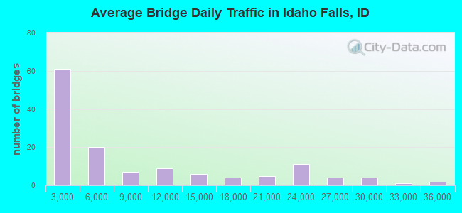
- 1,078,955Total average daily traffic
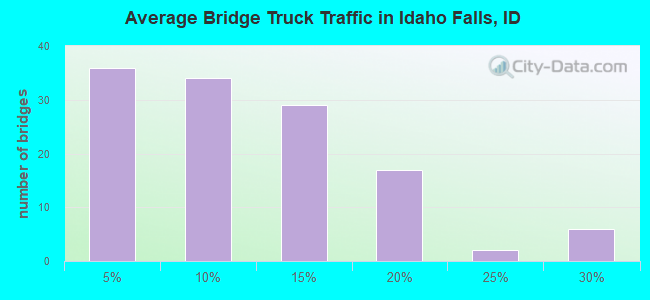
- 90,404Total average daily truck traffic
- National Bridge Inventory (NBI) Registered Bridges for Idaho Falls
- No street view available for this location
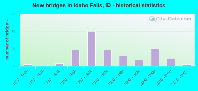
- New bridges - historical statistics
- 21920-1929
- 11930-1939
- 31940-1949
- 191950-1959
- 401960-1969
- 191970-1979
- 121980-1989
- 71990-1999
- 202000-2009
- 92010-2019
- 22020-2022
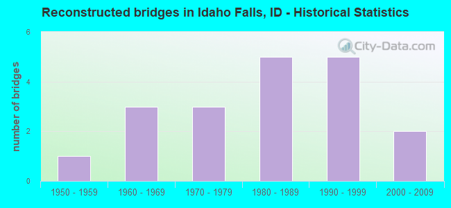
- Reconstructed bridges - Historical Statistics
- 11950-1959
- 31960-1969
- 31970-1979
- 51980-1989
- 51990-1999
- 22000-2009
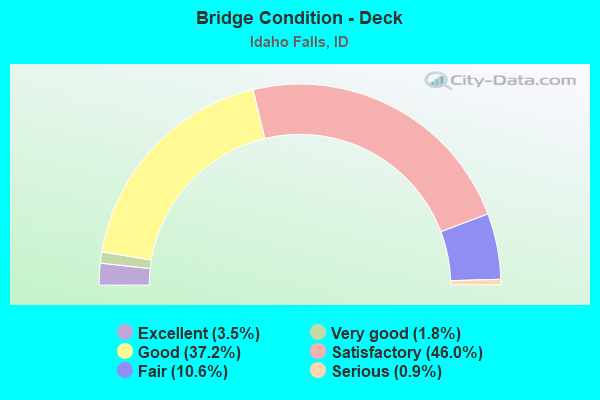
- Bridge Condition - Deck
- 3.5%Excellent
- 1.8%Very good
- 37.2%Good
- 46.0%Satisfactory
- 10.6%Fair
- 0.9%Serious
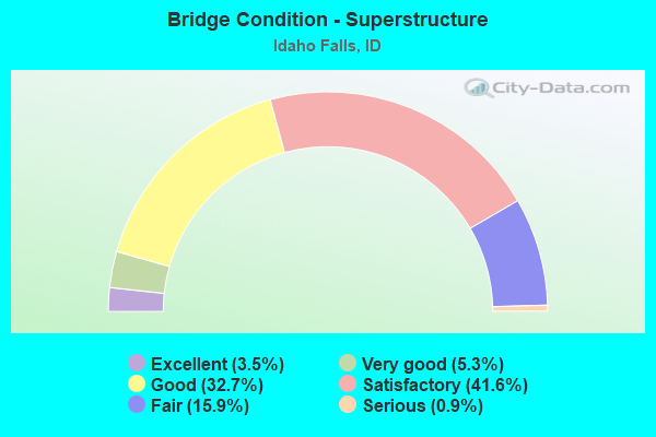
- Bridge Condition - Superstructure
- 3.5%Excellent
- 5.3%Very good
- 32.7%Good
- 41.6%Satisfactory
- 15.9%Fair
- 0.9%Serious
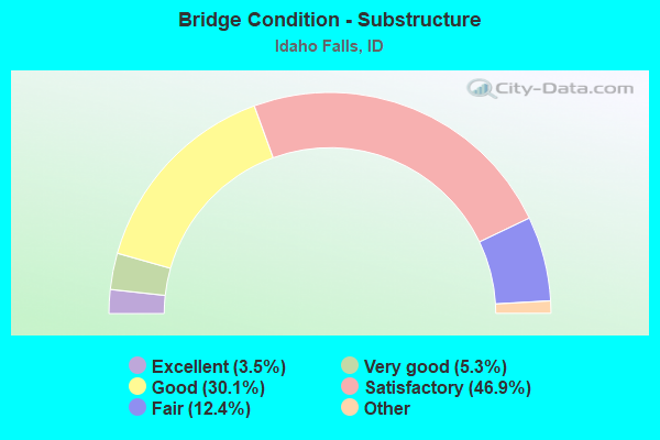
- Bridge Condition - Substructure
- 3.5%Excellent
- 5.3%Very good
- 30.1%Good
- 46.9%Satisfactory
- 12.4%Fair
- 1.8%Poor
- 0.9%Serious
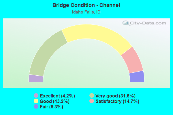
- Bridge Condition - Channel
- 4.2%Excellent
- 31.6%Very good
- 43.2%Good
- 14.7%Satisfactory
- 6.3%Fair
Find on map >> Show street view
Structure Number: 12096, Location: 3.0 N. SHELLEY (Lat: 43.439267, Lng: -112.121186), Route carried "under" structure: Interstate 15, Year Built: 1996, Structure Length: 0. m, Average Daily Traffic: 25,000 (year 2018), Truck Traffic: 16%, Features Intersected: I 15 SB-NB;N. SHELLEY IC, Facility Carried by Structure: NHS 6710;YORK RD
Minimum Vertical Clearance: 4.98m (16.34ft), Kilometerpoint: 182.197, Lanes on structure: 2, Lanes under structure: 4, Material/Design: Prestressed concrete continuous, Design/Construction: Box Beam or Girders - Multiple, Length of Maximum Span: 24.4m (80.1ft)
Find on map >> Show street view
Structure Number: 1231, Location: IN IDAHO FALLS (Lat: 43.504250, Lng: -112.056306), Route carried "under" structure: Interstate 15, Year Built: 1962, Structure Length: 0. m, Average Daily Traffic: 21,000 (year 2018), Truck Traffic: 19%, Features Intersected: I 15 NB-SB;JOHNS HOLE IC, Facility Carried by Structure: US 20
Minimum Vertical Clearance: 5.03m (16.50ft), Kilometerpoint: 191.669, Lanes on structure: 5, Lanes under structure: 4, Material/Design: Prestressed concrete, Design/Construction: Tee Beam, Length of Maximum Span: 19.2m (63.0ft)
Find on map >> Show street view
Structure Number: 1232, Location: IN IDAHO FALLS;LINDSAY BL (Lat: 43.504778, Lng: -112.053694), Route carried "under" structure: City street 7076, Year Built: 1966, Structure Length: 0. m, Average Daily Traffic: 5,200 (year 2018), Features Intersected: SMA 7076;LINDSAY BLVD.IC, Facility Carried by Structure: US 20 WBL & EBL
Minimum Vertical Clearance: 7.09m (23.26ft), Kilometerpoint: 2.126, Lanes on structure: 4, Lanes under structure: 2, Material/Design: Prestressed concrete, Design/Construction: Stringer/Multi-beam, Length of Maximum Span: 11.6m (38.1ft)
Find on map >> Show street view
Structure Number: 1234, Location: IN IDAHO FALLS;RIVERSIDE (Lat: 43.508500, Lng: -112.047167), Route carried "under" structure: City street 7096, Year Built: 1969, Structure Length: 0. m, Average Daily Traffic: 10,500 (year 2018), Features Intersected: SMA 7096;RIVERSIDE DR.IC, Facility Carried by Structure: US 20
Minimum Vertical Clearance: 4.79m (15.72ft), Kilometerpoint: 1.999, Lanes on structure: 4, Lanes under structure: 5, Material/Design: Steel continuous, Design/Construction: Stringer/Multi-beam, Length of Maximum Span: 28.7m (94.2ft)
Find on map >> Show street view
Structure Number: 12345, Location: IF; SCIENCE CENTER DR (Lat: 43.514708, Lng: -112.040411), Route carried "under" structure: Business County highway 7046, Year Built: 1987, Structure Length: 0. m, Average Daily Traffic: 16,000 (year 2018), Truck Traffic: 3%, Features Intersected: S7046;RR;SCIENCE CTR IC, Facility Carried by Structure: US 20 EBL
Minimum Vertical Clearance: 7.53m (24.70ft), Kilometerpoint: 0.547, Lanes on structure: 2, Lanes under structure: 3, Material/Design: Prestressed concrete, Design/Construction: Stringer/Multi-beam, Length of Maximum Span: 23.2m (76.1ft)
Find on map >> Show street view
Structure Number: 1235, Location: IF; SCIENCE CENTER DR (Lat: 43.515400, Lng: -112.040092), Route carried "under" structure: City street 7046, Year Built: 1970, Structure Length: 0. m, Average Daily Traffic: 16,000 (year 2018), Truck Traffic: 3%, Features Intersected: S7046;RR;SCIENCE CTR IC, Facility Carried by Structure: US 20 WBL
Minimum Vertical Clearance: 7.68m (25.20ft), Kilometerpoint: 0.570, Lanes on structure: 2, Lanes under structure: 3, Material/Design: Prestressed concrete, Design/Construction: Stringer/Multi-beam, Length of Maximum Span: 22.9m (75.1ft)
Find on map >> Show street view
Structure Number: 12355, Location: ID FALLS;LEWISVILLE HWY (Lat: 43.526811, Lng: -112.023950), Route carried "under" structure: Business US 20, Year Built: 1987, Structure Length: 0. m, Average Daily Traffic: 8,900 (year 2018), Truck Traffic: 7%, Features Intersected: US 20B;LEWISVILLE RD IC
Minimum Vertical Clearance: 5.26m (17.26ft), Kilometerpoint: 5.950, Lanes on structure: 2, Lanes under structure: 4, Material/Design: Prestressed concrete continuous, Design/Construction: Stringer/Multi-beam, Length of Maximum Span: 32.9m (107.9ft)
Find on map >> Show street view
Structure Number: 1236, Location: ID FALLS;LEWISVILLE HWY (Lat: 43.527414, Lng: -112.023267), Route carried "under" structure: Business US 20, Year Built: 1987, Structure Length: 0. m, Average Daily Traffic: 8,900 (year 2018), Truck Traffic: 7%, Features Intersected: US 20B;LEWISVILLE RD IC
Minimum Vertical Clearance: 5.23m (17.16ft), Kilometerpoint: 5.982, Lanes on structure: 2, Lanes under structure: 4, Material/Design: Prestressed concrete continuous, Design/Construction: Stringer/Multi-beam, Length of Maximum Span: 32.9m (107.9ft)
Find on map >> Show street view
Structure Number: 12373, Location: 4.0 S.W. UCON (Lat: 43.543000, Lng: -112.004944), Route carried "under" structure: County highway 6708, Year Built: 2005, Structure Length: 0. m, Average Daily Traffic: 4,600 (year 2018), Truck Traffic: 5%, Features Intersected: STC 6708; ST LEON RD IC, Facility Carried by Structure: US 20 EBL
Minimum Vertical Clearance: 5.41m (17.75ft), Kilometerpoint: 161.014, Lanes on structure: 2, Lanes under structure: 2, Material/Design: Prestressed concrete, Design/Construction: Stringer/Multi-beam, Length of Maximum Span: 33.8m (110.9ft)
Find on map >> Show street view
Structure Number: 12374, Location: 4.0 S.W. UCON (Lat: 43.543417, Lng: -112.004778), Route carried "under" structure: County highway 6708, Year Built: 2005, Structure Length: 0. m, Average Daily Traffic: 4,600 (year 2018), Truck Traffic: 5%, Features Intersected: STC 6708; ST LEON RD IC, Facility Carried by Structure: US 20 WBL
Minimum Vertical Clearance: 5.51m (18.08ft), Kilometerpoint: 161.034, Lanes on structure: 2, Lanes under structure: 2, Material/Design: Prestressed concrete, Design/Construction: Stringer/Multi-beam, Length of Maximum Span: 33.8m (110.9ft)
Find on map >> Show street view
Structure Number: 21556, Location: IN IDAHO FALLS (Lat: 43.489222, Lng: -112.056139), Route carried "under" structure: City street , Year Built: 2012, Structure Length: 0. m, Average Daily Traffic: 100 (year 2018), Truck Traffic: 10%, Features Intersected: I 15 NB-SB; PANCHERI GS, Facility Carried by Structure: SMA 7406; PANCHERI
Minimum Vertical Clearance: 5.49m (18.01ft), Kilometerpoint: 164.179, Lanes on structure: 2, Lanes under structure: 2, Material/Design: Prestressed concrete, Design/Construction: Stringer/Multi-beam, Length of Maximum Span: 34.1m (111.9ft)
Find on map >> Show street view
Structure Number: 21556, Location: IN IDAHO FALLS (Lat: 43.489222, Lng: -112.056139), Route carried "under" structure: Interstate 15, Year Built: 2012, Structure Length: 0. m, Average Daily Traffic: 23,000 (year 2018), Truck Traffic: 19%, Features Intersected: I 15 NB-SB; PANCHERI GS, Facility Carried by Structure: SMA 7406; PANCHERI
Minimum Vertical Clearance: 5.49m (18.01ft), Kilometerpoint: 189.975, Lanes on structure: 2, Lanes under structure: 4, Material/Design: Prestressed concrete, Design/Construction: Stringer/Multi-beam, Length of Maximum Span: 34.1m (111.9ft)
Find on map >> Show street view
Structure Number: 21614, Location: 1.1 W. IDAHO FALLS (Lat: 43.467833, Lng: -112.086389), Route carried "under" structure: Interstate 15, Year Built: 2007, Structure Length: 0. m, Average Daily Traffic: 23,000 (year 2018), Truck Traffic: 19%, Features Intersected: I 15;SUNNYSIDE RD IC
Minimum Vertical Clearance: 5.39m (17.68ft), Kilometerpoint: 186.587, Lanes on structure: 5, Lanes under structure: 4, Material/Design: Steel continuous, Design/Construction: Stringer/Multi-beam, Length of Maximum Span: 48.8m (160.1ft)
Find on map >> Show street view
Structure Number: 31375, Location: 2.8 S. 3.2 W. IDAHO FALLS (Lat: 43.451822, Lng: -112.102878), Route carried "under" structure: Interstate 15, Year Built: 1962, Structure Length: 0. m, Average Daily Traffic: 28,000 (year 2018), Truck Traffic: 16%, Features Intersected: I 15;NEW SWEDEN RD.GS, Facility Carried by Structure: NEW SWEDEN ROAD
Minimum Vertical Clearance: 5.09m (16.70ft), Kilometerpoint: 184.255, Lanes on structure: 2, Lanes under structure: 4, Material/Design: Prestressed concrete, Design/Construction: Stringer/Multi-beam, Length of Maximum Span: 21.0m (68.9ft)
Find on map >> Show street view
Structure Number: 31385, Location: 3.4 N. 1.4 W. IDAHO FALLS (Lat: 43.538994, Lng: -112.069086), Route carried "under" structure: Interstate 15, Year Built: 1962, Structure Length: 0. m, Average Daily Traffic: 6,500 (year 2018), Truck Traffic: 25%, Features Intersected: I 15 NB-SB;OSGOOD RD.GS, Facility Carried by Structure: OSGOOD ROAD
Minimum Vertical Clearance: 5.03m (16.50ft), Kilometerpoint: 195.696, Lanes on structure: 2, Lanes under structure: 4, Material/Design: Prestressed concrete, Design/Construction: Stringer/Multi-beam, Length of Maximum Span: 15.5m (50.9ft)
Find on map >> Show street view
Structure Number: 3139, Location: 5.6 N. 1.7 W. IDAHO FALLS (Lat: 43.569833, Lng: -112.072972), Route carried "under" structure: Interstate 15, Year Built: 1962, Structure Length: 0. m, Average Daily Traffic: 6,500 (year 2018), Truck Traffic: 25%, Features Intersected: I 15 NB-SB;PAYNE RD.GS, Facility Carried by Structure: PAYNE ROAD
Minimum Vertical Clearance: 4.98m (16.34ft), Kilometerpoint: 199.161, Lanes on structure: 2, Lanes under structure: 4, Material/Design: Prestressed concrete, Design/Construction: Stringer/Multi-beam, Length of Maximum Span: 14.9m (48.9ft)
Find on map >> Show street view
Structure Number: 31395, Location: 7.1 N. IDAHO FALLS (Lat: 43.596972, Lng: -112.077250), Route carried "under" structure: Interstate 15, Year Built: 1962, Structure Length: 0. m, Average Daily Traffic: 6,500 (year 2018), Truck Traffic: 25%, Features Intersected: I 15;SHATTOCK BUTTE GS, Facility Carried by Structure: SHATTOCK BUTTE RD.
Minimum Vertical Clearance: 4.88m (16.01ft), Kilometerpoint: 202.214, Lanes on structure: 2, Lanes under structure: 4, Material/Design: Prestressed concrete, Design/Construction: Stringer/Multi-beam, Length of Maximum Span: 14.9m (48.9ft)
Find on map >> Show street view
Structure Number: 31421, Location: IN IDAHO FALLS (Lat: 43.496444, Lng: -112.034333), Route carried "under" structure: US 26, Year Built: 2001, Structure Length: 0. m, Average Daily Traffic: 18,000 (year 2018), Truck Traffic: 4%, Features Intersected: US 26 NB-SB;S.BLVD GS, Facility Carried by Structure: SOUTH BLVD
Minimum Vertical Clearance: 5.39m (17.68ft), Kilometerpoint: 536.721, Lanes on structure: 1, Lanes under structure: 4, Material/Design: Steel, Design/Construction: Stringer/Multi-beam, Length of Maximum Span: 13.1m (43.0ft)