Bridge Statistics for Indio, California (CA)
Condition, Traffic, Stress, Structural Evaluation, Project Costs
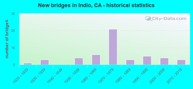
- New bridges - historical statistics
- 11920-1929
- 31930-1939
- 41950-1959
- 61960-1969
- 211970-1979
- 31980-1989
- 51990-1999
- 42000-2009
- 32010-2019
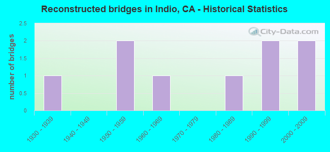
- Reconstructed bridges - Historical Statistics
- 11930-1939
- 01940-1949
- 21950-1959
- 11960-1969
- 01970-1979
- 11980-1989
- 21990-1999
- 22000-2009
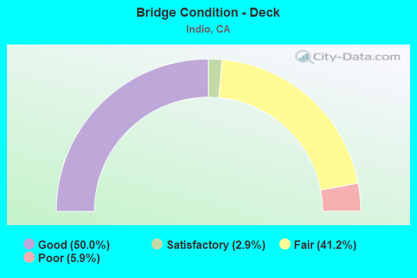
- Bridge Condition - Deck
- 50.0%Good
- 2.9%Satisfactory
- 41.2%Fair
- 5.9%Poor
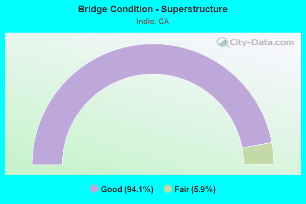
- Bridge Condition - Superstructure
- 94.1%Good
- 5.9%Fair
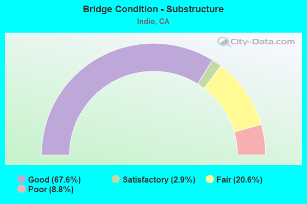
- Bridge Condition - Substructure
- 67.6%Good
- 2.9%Satisfactory
- 20.6%Fair
- 8.8%Poor
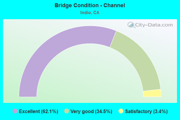
- Bridge Condition - Channel
- 62.1%Excellent
- 34.5%Very good
- 3.4%Satisfactory
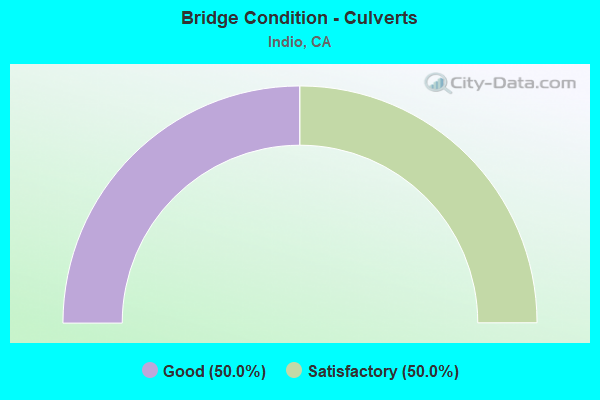
- Bridge Condition - Culverts
- 50.0%Good
- 50.0%Satisfactory
Find on map >> Show street view
Structure Number: 56C0564, Location: 0.1 MI N/O AVENUE 50 (Lat: 33.686436, Lng: -116.251167), Route carried "on" structure: City street , Year Built: 2009, Status: Open, Structure Length: 1.34m (4.40ft), Average Daily Traffic: 8,800 (year 2017), Truck Traffic: 2%, Average Future Daily Traffic: 5,084 (year 2037), Design Load: HS 20, Features Intersected: COACHELLA CANAL, Facility Carried by Structure: MADISON STREET
Minimum Vertical Clearance: 30+ m (98+ ft), Kilometerpoint: 0.000, Lanes on structure: 2, Owner: City or Municipal Highway Agency, Approaching Roadway Width: 18.3m (60.0ft), Skew: 6 degrees, Material/Design: Concrete, Design/Construction: Culvert, Number Of Spans In Main Unit: 2, Length of Maximum Span: 6.5m (21.3ft), Curb or Sidewalk Widths: Left: 1.8m (5.9ft), Right: 0.0m, Curb-To-Curb Width: 18.3m (60.0ft), Out-to-Out Width: 21.6m (70.9ft)
Condition: Channel: Excellent, Culverts: Good, Operating Rating: 54.1 metric tons, Method Used To Determine Operating Rating: Field evaluation and documented engineering judgment, Inventory Rating: 32.4 metric tons, Method Used To Determine Inventory Rating: Field evaluation and documented engineering judgment, Structural Evaluation: Better than present minimum criteria, Deck Geometry: Superior to present desirable criteria, Waterway Adequacy: Equal to present desirable criteria, Approach Roadway Alignment: Better than present minimum criteria, Designated Inspection Frequency: Every 48 months, Inspection Date: October 2019
Find on map >> Show street view
Structure Number: 56 0611, Location: 08-RIV-010-R54.74-IND (Lat: 33.739786, Lng: -116.233986), Route carried "under" structure: Interstate 10, Year Built: 1972, Structure Length: 0. m, Average Daily Traffic: 64,000 (year 2014), Truck Traffic: 32%, Features Intersected: INTERSTATE 10, Facility Carried by Structure: MONROE ST
Minimum Vertical Clearance: 5.43m (17.81ft), Kilometerpoint: 54.740, Lanes on structure: 3, Lanes under structure: 6, Material/Design: Prestressed concrete continuous, Design/Construction: Box Beam or Girders - Multiple, Length of Maximum Span: 39.0m (128.0ft)
Find on map >> Show street view
Structure Number: 56 0612, Location: 08-RIV-010-R55.74-IND (Lat: 33.738275, Lng: -116.216639), Route carried "under" structure: Interstate 10, Year Built: 1972, Structure Length: 0. m, Average Daily Traffic: 59,000 (year 2014), Truck Traffic: 32%, Features Intersected: INTERSTATE 10, Facility Carried by Structure: JACKSON ST
Minimum Vertical Clearance: 5.33m (17.49ft), Kilometerpoint: 55.740, Lanes on structure: 2, Lanes under structure: 6, Material/Design: Prestressed concrete continuous, Design/Construction: Box Beam or Girders - Multiple, Length of Maximum Span: 41.1m (134.8ft)
Find on map >> Show street view
Structure Number: 56 0614, Location: 08-RIV-010-R56.95-IND (Lat: 33.726364, Lng: -116.201311), Route carried "under" structure: Interstate 10, Year Built: 1972, Structure Length: 0. m, Average Daily Traffic: 66,000 (year 2012), Truck Traffic: 33%, Features Intersected: INTERSTATE 10, Facility Carried by Structure: GOLF CENTER PKWY
Minimum Vertical Clearance: 5.16m (16.93ft), Kilometerpoint: 56.950, Lanes on structure: 4, Lanes under structure: 6, Material/Design: Prestressed concrete continuous, Design/Construction: Box Beam or Girders - Multiple, Length of Maximum Span: 39.0m (128.0ft)
Find on map >> Show street view
Structure Number: 56 0620G, Location: 08-RIV-086-R22.94-IND (Lat: 33.715981, Lng: -116.190458), Route carried "under" structure: Interstate 10, Year Built: 1972, Structure Length: 0. m, Average Daily Traffic: 11,000 (year 2011), Truck Traffic: 30%, Features Intersected: INTERSTATE 10 EB
Minimum Vertical Clearance: 5.20m (17.06ft), Kilometerpoint: 57.830, Lanes on structure: 2, Lanes under structure: 2, Material/Design: Prestressed concrete continuous, Design/Construction: Box Beam or Girders - Multiple, Length of Maximum Span: 61.9m (203.1ft)
Find on map >> Show street view
Structure Number: 56 0862, Location: 08-RIV-010-R52.40-IND (Lat: 33.750194, Lng: -116.269253), Route carried "under" structure: Ramp Interstate 10, Year Built: 2018, Structure Length: 0. m, Average Daily Traffic: 6,800 (year 2012), Truck Traffic: 30%, Features Intersected: INTERSTATE 10, Facility Carried by Structure: JEFFERSON ST
Minimum Vertical Clearance: 5.87m (19.26ft), Kilometerpoint: 52.400, Lanes on structure: 6, Lanes under structure: 1, Material/Design: Prestressed concrete, Design/Construction: Box Beam or Girders - Multiple, Length of Maximum Span: 75.8m (248.7ft)
Find on map >> Show street view
Structure Number: 56 0862, Location: 08-RIV-010-R52.40-IND (Lat: 33.750194, Lng: -116.269253), Route carried "under" structure: Ramp Interstate 10, Year Built: 2018, Structure Length: 0. m, Average Daily Traffic: 6,800 (year 2012), Truck Traffic: 30%, Features Intersected: INTERSTATE 10, Facility Carried by Structure: JEFFERSON ST
Minimum Vertical Clearance: 7.37m (24.18ft), Kilometerpoint: 52.400, Lanes on structure: 6, Lanes under structure: 1, Material/Design: Prestressed concrete, Design/Construction: Box Beam or Girders - Multiple, Length of Maximum Span: 75.8m (248.7ft)
Find on map >> Show street view
Structure Number: 56 0862, Location: 08-RIV-010-R52.40-IND (Lat: 33.750194, Lng: -116.269253), Route carried "under" structure: Interstate 10, Year Built: 2018, Structure Length: 0. m, Average Daily Traffic: 90,000 (year 2012), Truck Traffic: 33%, Features Intersected: INTERSTATE 10, Facility Carried by Structure: JEFFERSON ST
Minimum Vertical Clearance: 5.87m (19.26ft), Kilometerpoint: 52.400, Lanes on structure: 6, Lanes under structure: 6, Material/Design: Prestressed concrete, Design/Construction: Box Beam or Girders - Multiple, Length of Maximum Span: 75.8m (248.7ft)
Find on map >> Show street view
Structure Number: 56C0291, Location: AT INDIO BOULEVARD (Lat: 33.719994, Lng: -116.216108), Route carried "under" structure: City street , Year Built: 1964, Structure Length: 0. m, Average Daily Traffic: 13,000 (year 2011), Truck Traffic: 1%, Features Intersected: INDIO BOULEVARD, Facility Carried by Structure: JACKSON STREET
Minimum Vertical Clearance: 5.99m (19.65ft), Kilometerpoint: 0.000, Lanes on structure: 4, Lanes under structure: 4, Material/Design: Steel, Design/Construction: Stringer/Multi-beam, Length of Maximum Span: 29.0m (95.1ft)
Find on map >> Show street view
Structure Number: 56C0392, Location: AT INDIO BLVD. (Lat: 33.729169, Lng: -116.233364), Route carried "under" structure: City street , Year Built: 1990, Structure Length: 0. m, Average Daily Traffic: 28,700 (year 2011), Truck Traffic: 1%, Features Intersected: UP RR,AMTRAK, INDIO BLVD, Facility Carried by Structure: MONROE STREET
Minimum Vertical Clearance: 5.99m (19.65ft), Kilometerpoint: 0.000, Lanes on structure: 4, Lanes under structure: 4, Material/Design: Prestressed concrete continuous, Design/Construction: Stringer/Multi-beam, Length of Maximum Span: 30.5m (100.1ft)
Find on map >> Show street view
Structure Number: 56C0547, Location: 0.75 MI SW/O I-10 (Lat: 33.716186, Lng: -116.209633), Route carried "under" structure: County highway , Year Built: 1978, Structure Length: 0. m, Average Daily Traffic: 11,600 (year 2011), Truck Traffic: 1%, Features Intersected: UP RR & AMTRAK, INDIO BL, Facility Carried by Structure: AUTOGOLF CENTER DR
Minimum Vertical Clearance: 5.16m (16.93ft), Kilometerpoint: 0.000, Lanes on structure: 2, Lanes under structure: 4, Material/Design: Prestressed concrete, Design/Construction: Stringer/Multi-beam, Length of Maximum Span: 34.1m (111.9ft)