Bridge Statistics for Jackson, Michigan (MI)
Condition, Traffic, Stress, Structural Evaluation, Project Costs
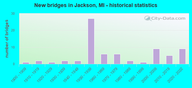
- New bridges - historical statistics
- 11900-1909
- 21910-1919
- 11920-1929
- 21930-1939
- 21940-1949
- 271950-1959
- 61960-1969
- 61970-1979
- 21980-1989
- 11990-1999
- 92000-2009
- 52010-2019
- 92020-2022
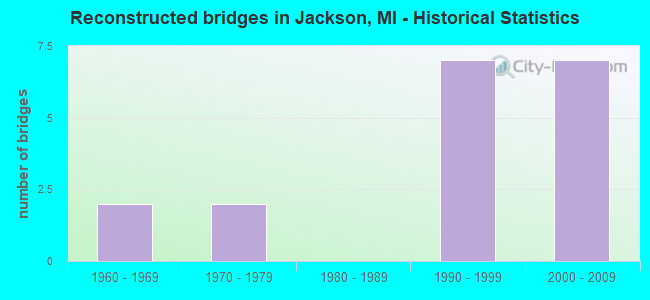
- Reconstructed bridges - Historical Statistics
- 21960-1969
- 21970-1979
- 01980-1989
- 71990-1999
- 72000-2009
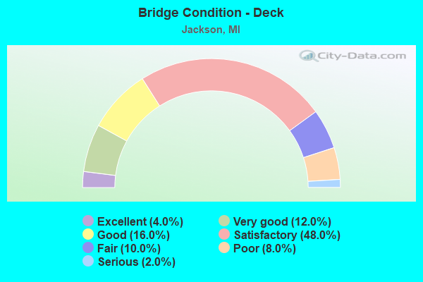
- Bridge Condition - Deck
- 4.0%Excellent
- 12.0%Very good
- 16.0%Good
- 48.0%Satisfactory
- 10.0%Fair
- 8.0%Poor
- 2.0%Serious
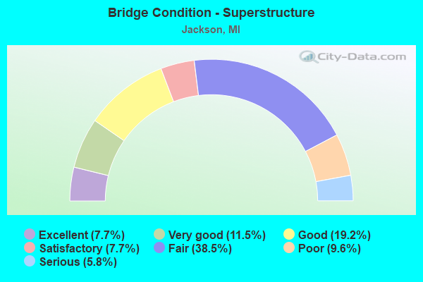
- Bridge Condition - Superstructure
- 7.7%Excellent
- 11.5%Very good
- 19.2%Good
- 7.7%Satisfactory
- 38.5%Fair
- 9.6%Poor
- 5.8%Serious
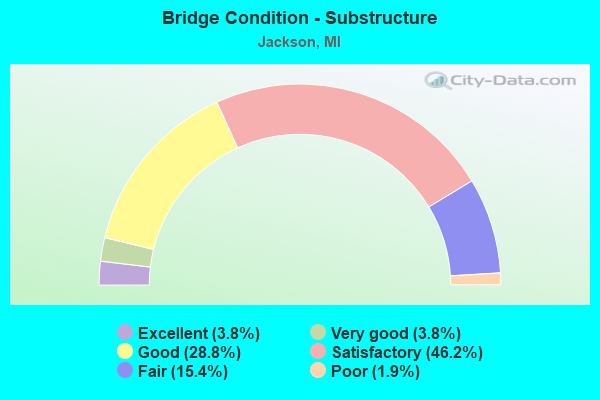
- Bridge Condition - Substructure
- 3.8%Excellent
- 3.8%Very good
- 28.8%Good
- 46.2%Satisfactory
- 15.4%Fair
- 1.9%Poor
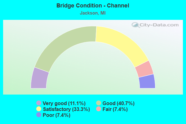
- Bridge Condition - Channel
- 11.1%Very good
- 40.7%Good
- 33.3%Satisfactory
- 7.4%Fair
- 7.4%Poor
Find on map >> Show street view
Structure Number: 454, Location: 0.3 MI E OF LENTNER RD (Lat: 44.051511, Lng: -83.759456), Route carried "on" structure: County highway , Year Built: 1920, Status: Closed, Structure Length: 0.91m (2.99ft), Average Daily Traffic: 198 (year 1998), Average Future Daily Traffic: 75 (year 1977), Design Load: HS 20+Mod, Features Intersected: BIG CREEK A DRAIN, Facility Carried by Structure: NOGGLE ROAD
Minimum Vertical Clearance: 30.48m (100.00ft), Kilometerpoint: 4.135, Lanes on structure: 2, Owner: County Highway Agency, Approaching Roadway Width: 7.9m (25.9ft), Material/Design: Steel, Design/Construction: Stringer/Multi-beam, Number Of Spans In Main Unit: 1, Length of Maximum Span: 8.2m (26.9ft), Curb-To-Curb Width: 5.2m (17.1ft), Out-to-Out Width: 5.2m (17.1ft)
Condition: Deck: Fair, Superstructure: Serious, Substructure: Fair, Channel: Poor, Operating Rating: 10.0 metric tons, Method Used To Determine Operating Rating: Load Factor (LF) rating reported by rating factor (RF) method using MS18 loading, Inventory Rating: 5.8 metric tons, Method Used To Determine Inventory Rating: Load Factor (LF) rating reported by rating factor (RF) method using MS18 loading, Waterway Adequacy: Somewhat better than minimum adequacy, Approach Roadway Alignment: Better than present minimum criteria, Bridge Posting: Required (Relationship of Operating Rating to Maximum Legal Load: > 39.9% below), Length Of Structure Improvement: 0.91m (2.99ft), Designated Inspection Frequency: Every 24 months, Inspection Date: Febuary 2021, Bridge Improvement Cost: $120,000, Roadway Improvement Cost: $12,000, Total Project Cost: $141,000, Deck Structure Type: Wood or Timber, Wearing Surface/Protective System: Wearing Surface: Bituminous
Find on map >> Show street view
Structure Number: 455, Location: 0.3 MI W OF LENTNER (Lat: 44.062853, Lng: -83.772400), Route carried "on" structure: County highway , Year Built: 1972, Status: Open, Structure Length: 0.73m (2.40ft), Average Daily Traffic: 19 (year 1998), Average Future Daily Traffic: 5 (year 1977), Design Load: HS 20+Mod, Features Intersected: BIG CREEK A DRAIN, Facility Carried by Structure: BAILIFF ROAD
Minimum Vertical Clearance: 30.48m (100.00ft), Kilometerpoint: 1.115, Lanes on structure: 2, Owner: County Highway Agency, Approaching Roadway Width: 7.9m (25.9ft), Material/Design: Steel, Design/Construction: Culvert, Number Of Spans In Main Unit: 2, Length of Maximum Span: 3.6m (11.8ft), Curb-To-Curb Width: 7.3m (24.0ft), Out-to-Out Width: 7.3m (24.0ft)
Condition: Channel: Good, Culverts: Satisfactory, Operating Rating: 39.5 metric tons, Method Used To Determine Operating Rating: Load Factor (LF) rating reported by rating factor (RF) method using MS18 loading, Inventory Rating: 23.7 metric tons, Method Used To Determine Inventory Rating: Load Factor (LF) rating reported by rating factor (RF) method using MS18 loading, Structural Evaluation: Equal to present minimum criteria, Deck Geometry: Equal to present minimum criteria, Waterway Adequacy: Equal to present minimum criteria, Approach Roadway Alignment: Equal to present minimum criteria, Designated Inspection Frequency: Every 24 months, Inspection Date: August 2021
Find on map >> Show street view
Structure Number: 4387, Location: 3 MI NE OF I-94 (Lat: 42.312133, Lng: -84.387108), Route carried "on" structure: State highway 106, Year Built: 1976, Status: Open, Structure Length: 2.74m (8.99ft), Average Daily Traffic: 6,730 (year 2007), Truck Traffic: 3%, Average Future Daily Traffic: 11,467 (year 2018), Design Load: HS 20, Features Intersected: PORTAGE RIVER
Minimum Vertical Clearance: 30.48m (100.00ft), Kilometerpoint: 7.395, Lanes on structure: 2, Base Highway Network: Yes (Inventory Route: 90, Subroute: 4), Owner: State Highway Agency, Approaching Roadway Width: 15.2m (49.9ft), Material/Design: Prestressed concrete, Design/Construction: Stringer/Multi-beam, Number Of Spans In Main Unit: 2, Length of Maximum Span: 13.7m (44.9ft), Curb-To-Curb Width: 14.6m (47.9ft), Out-to-Out Width: 15.4m (50.5ft)
Condition: Deck: Satisfactory, Superstructure: Fair, Substructure: Satisfactory, Channel: Satisfactory, Operating Rating: 52.2 metric tons, Method Used To Determine Operating Rating: Load Factor (LF) rating reported by rating factor (RF) method using MS18 loading, Inventory Rating: 31.4 metric tons, Method Used To Determine Inventory Rating: Load Factor (LF) rating reported by rating factor (RF) method using MS18 loading, Structural Evaluation: Somewhat better than minimum adequacy, Deck Geometry: Superior to present desirable criteria, Waterway Adequacy: Equal to present desirable criteria, Approach Roadway Alignment: Equal to present desirable criteria, Designated Inspection Frequency: Every 24 months, Inspection Date: August 2020, Deck Structure Type: Concrete Cast-file-Place, Wearing Surface/Protective System: Wearing Surface: Monolithic Concrete
Find on map >> Show street view
Structure Number: 4393, Location: @ I-94 BL (MICHIGAN AV) (Lat: 42.254889, Lng: -84.476061), Route carried "on" structure: State highway 60, Year Built: 1958, Year Reconstructed: 2011, Status: Open, Structure Length: 7.32m (24.02ft), Average Daily Traffic: 5,270 (year 2007), Truck Traffic: 7%, Average Future Daily Traffic: 7,945 (year 2018), Design Load: HS 20, Features Intersected: MDOT RR COR & I-94 BL
Minimum Vertical Clearance: 30.48m (100.00ft), Kilometerpoint: 3.481, Lanes on structure: 3, Lanes under structure: 2, Base Highway Network: Yes (Inventory Route: 89, Subroute: 2), Owner: State Highway Agency, Approaching Roadway Width: 13.9m (45.6ft), Skew: 10 degrees, Material/Design: Steel, Design/Construction: Stringer/Multi-beam, Number Of Spans In Main Unit: 4, Length of Maximum Span: 21.2m (69.6ft), Curb-To-Curb Width: 13.5m (44.3ft), Out-to-Out Width: 14.6m (47.9ft)
Condition: Deck: Satisfactory, Superstructure: Fair, Substructure: Satisfactory, Operating Rating: 89.5 metric tons, Method Used To Determine Operating Rating: Load Factor (LF), Inventory Rating: 53.7 metric tons, Method Used To Determine Inventory Rating: Load Factor (LF), Structural Evaluation: Somewhat better than minimum adequacy, Deck Geometry: Meets minimum limits, Underclear: High priority of corrective action, Approach Roadway Alignment: Equal to present desirable criteria, Designated Inspection Frequency: Every 24 months, Inspection Date: May 2021, Deck Structure Type: Concrete Cast-file-Place, Wearing Surface/Protective System: Wearing Surface: Latex Concrete
Find on map >> Show street view
Structure Number: 4394, Location: @ I-94 BL (Lat: 42.254869, Lng: -84.476439), Route carried "on" structure: State highway 60, Year Built: 1958, Year Reconstructed: 2011, Status: Open, Structure Length: 7.32m (24.02ft), Average Daily Traffic: 5,270 (year 2007), Truck Traffic: 7%, Average Future Daily Traffic: 7,945 (year 2018), Design Load: HS 20, Features Intersected: MDOT RR COR & I-94 BL
Minimum Vertical Clearance: 30.48m (100.00ft), Kilometerpoint: 3.309, Lanes on structure: 2, Lanes under structure: 3, Base Highway Network: Yes (Inventory Route: 89, Subroute: 1), Owner: State Highway Agency, Approaching Roadway Width: 11.2m (36.7ft), Skew: 10 degrees, Material/Design: Steel, Design/Construction: Stringer/Multi-beam, Number Of Spans In Main Unit: 4, Length of Maximum Span: 21.2m (69.6ft), Curb-To-Curb Width: 9.8m (32.2ft), Out-to-Out Width: 11.0m (36.1ft)
Condition: Deck: Satisfactory, Superstructure: Fair, Substructure: Satisfactory, Operating Rating: 94.7 metric tons, Method Used To Determine Operating Rating: Load Factor (LF), Inventory Rating: 56.8 metric tons, Method Used To Determine Inventory Rating: Load Factor (LF), Structural Evaluation: Somewhat better than minimum adequacy, Deck Geometry: Meets minimum limits, Underclear: High priority of corrective action, Approach Roadway Alignment: Equal to present desirable criteria, Designated Inspection Frequency: Every 24 months, Inspection Date: May 2021, Deck Structure Type: Concrete Cast-file-Place, Wearing Surface/Protective System: Wearing Surface: Latex Concrete
Find on map >> Show street view
Structure Number: 4395, Location: 2.5 MI S OF I-94 (Lat: 42.232814, Lng: -84.474839), Route carried "on" structure: County highway , Year Built: 1958, Status: Open, Structure Length: 7.47m (24.51ft), Average Daily Traffic: 6,200 (year 1988), Average Future Daily Traffic: 5,610 (year 1977), Design Load: H 15, Features Intersected: M-60, Facility Carried by Structure: MCCAIN RD
Minimum Vertical Clearance: 30.48m (100.00ft), Kilometerpoint: 10.242, Lanes on structure: 2, Lanes under structure: 4, Owner: State Highway Agency, Approaching Roadway Width: 10.3m (33.8ft), Material/Design: Concrete continuous, Design/Construction: Tee Beam, Number Of Spans In Main Unit: 4, Length of Maximum Span: 21.6m (70.9ft), Curb-To-Curb Width: 8.9m (29.2ft), Out-to-Out Width: 10.1m (33.1ft)
Condition: Deck: Satisfactory, Superstructure: Satisfactory, Substructure: Satisfactory, Operating Rating: 44.4 metric tons, Method Used To Determine Operating Rating: Load Factor (LF) rating reported by rating factor (RF) method using MS18 loading, Inventory Rating: 26.9 metric tons, Method Used To Determine Inventory Rating: Load Factor (LF) rating reported by rating factor (RF) method using MS18 loading, Structural Evaluation: Equal to present minimum criteria, Deck Geometry: Meets minimum limits, Underclear: High priority of corrective action, Approach Roadway Alignment: Equal to present desirable criteria, Designated Inspection Frequency: Every 24 months, Inspection Date: May 2021, Deck Structure Type: Concrete Cast-file-Place, Wearing Surface/Protective System: Wearing Surface: Latex Concrete
Find on map >> Show street view
Structure Number: 4396, Location: @ I-94 (Lat: 42.268928, Lng: -84.476867), Route carried "on" structure: Ramp Interstate 94, Year Built: 2020, Status: Open, Structure Length: 4.81m (15.78ft), Average Daily Traffic: 650 (year 2020), Truck Traffic: 9%, Average Future Daily Traffic: 725 (year 2040), Design Load: Greater than HL93, Features Intersected: I-94
Minimum Vertical Clearance: 30.48m (100.00ft), Kilometerpoint: 5.041, Lanes on structure: 1, Lanes under structure: 5, Owner: State Highway Agency, Approaching Roadway Width: 8.5m (27.9ft), Material/Design: Prestressed concrete, Design/Construction: Stringer/Multi-beam, Number Of Spans In Main Unit: 2, Length of Maximum Span: 24.8m (81.4ft), Curb-To-Curb Width: 8.5m (27.9ft), Out-to-Out Width: 9.3m (30.5ft)
Condition: Deck: Excellent, Superstructure: Excellent, Substructure: Excellent, Operating Rating: 55.4 metric tons, Method Used To Determine Operating Rating: Load and Resistance Factor Rating (LRFR) rating reported by rating factor(RF) method using HL-93 loadings, Inventory Rating: 39.5 metric tons, Method Used To Determine Inventory Rating: Load and Resistance Factor Rating (LRFR) rating reported by rating factor(RF) method using HL-93 loadings, Structural Evaluation: Superior to present desirable criteria, Deck Geometry: Superior to present desirable criteria, Underclear: High priority of corrective action, Approach Roadway Alignment: Equal to present desirable criteria, Designated Inspection Frequency: Every 24 months, Inspection Date: May 2021, Bridge Improvement Cost: $170,000, Deck Structure Type: Concrete Cast-file-Place, Wearing Surface/Protective System: Wearing Surface: Monolithic Concrete, Deck Protection: Epoxy Coated Reinforcing
Find on map >> Show street view
Structure Number: 4397, Location: @ I-94 (Lat: 42.268928, Lng: -84.477239), Route carried "on" structure: Ramp Interstate 94, Year Built: 2020, Status: Open, Structure Length: 4.81m (15.78ft), Average Daily Traffic: 6,625 (year 2020), Truck Traffic: 9%, Average Future Daily Traffic: 7,550 (year 2040), Design Load: Greater than HL93, Features Intersected: I-94
Minimum Vertical Clearance: 30.48m (100.00ft), Kilometerpoint: 4.870, Lanes on structure: 2, Lanes under structure: 4, Owner: State Highway Agency, Approaching Roadway Width: 11.9m (39.0ft), Material/Design: Prestressed concrete, Design/Construction: Stringer/Multi-beam, Number Of Spans In Main Unit: 2, Length of Maximum Span: 24.8m (81.4ft), Curb-To-Curb Width: 11.9m (39.0ft), Out-to-Out Width: 12.6m (41.3ft)
Condition: Deck: Very good, Superstructure: Excellent, Substructure: Excellent, Operating Rating: 58.6 metric tons, Method Used To Determine Operating Rating: Load and Resistance Factor Rating (LRFR) rating reported by rating factor(RF) method using HL-93 loadings, Inventory Rating: 41.5 metric tons, Method Used To Determine Inventory Rating: Load and Resistance Factor Rating (LRFR) rating reported by rating factor(RF) method using HL-93 loadings, Structural Evaluation: Superior to present desirable criteria, Deck Geometry: Superior to present desirable criteria, Underclear: High priority of corrective action, Approach Roadway Alignment: Equal to present desirable criteria, Designated Inspection Frequency: Every 24 months, Inspection Date: May 2021, Bridge Improvement Cost: $118,000, Deck Structure Type: Concrete Cast-file-Place, Wearing Surface/Protective System: Wearing Surface: Monolithic Concrete, Deck Protection: Epoxy Coated Reinforcing
Find on map >> Show street view
Structure Number: 4403, Location: IN JACKSON (Lat: 42.236333, Lng: -84.395183), Route carried "on" structure: Business US 127, Year Built: 1966, Status: Open, Structure Length: 4.23m (13.88ft), Average Daily Traffic: 11,810 (year 2007), Truck Traffic: 8%, Average Future Daily Traffic: 15,004 (year 2018), Design Load: HS 20, Features Intersected: CONRAIL
Minimum Vertical Clearance: 30.48m (100.00ft), Kilometerpoint: 1.191, Lanes on structure: 4, Base Highway Network: Yes (Inventory Route: 338, Subroute: 12), Owner: State Highway Agency, Approaching Roadway Width: 22.6m (74.1ft), Skew: 20 degrees, Material/Design: Prestressed concrete, Design/Construction: Stringer/Multi-beam, Number Of Spans In Main Unit: 3, Length of Maximum Span: 14.3m (46.9ft), Curb or Sidewalk Widths: Left: 0.2m (0.7ft), Right: 0.2m (0.7ft), Curb-To-Curb Width: 22.6m (74.1ft), Out-to-Out Width: 23.2m (76.1ft)
Condition: Deck: Satisfactory, Superstructure: Fair, Substructure: Fair, Operating Rating: 72.3 metric tons, Method Used To Determine Operating Rating: Load Factor (LF) rating reported by rating factor (RF) method using MS18 loading, Inventory Rating: 41.1 metric tons, Method Used To Determine Inventory Rating: Load Factor (LF) rating reported by rating factor (RF) method using MS18 loading, Structural Evaluation: Somewhat better than minimum adequacy, Deck Geometry: Superior to present desirable criteria, Approach Roadway Alignment: Equal to present desirable criteria, Designated Inspection Frequency: Every 24 months, Inspection Date: August 2020, Deck Structure Type: Concrete Cast-file-Place, Wearing Surface/Protective System: Wearing Surface: Monolithic Concrete
Find on map >> Show street view
Structure Number: 4404, Location: IN JACKSON (WEST AVE) (Lat: 42.253569, Lng: -84.423397), Route carried "on" structure: State highway 50, Year Built: 2012, Status: Open, Structure Length: 4.07m (13.35ft), Average Daily Traffic: 15,194 (year 2007), Truck Traffic: 5%, Average Future Daily Traffic: 22,400 (year 2031), Design Load: Greater than HL93, Features Intersected: MDOT RR CORRIDOR
Minimum Vertical Clearance: 30.48m (100.00ft), Kilometerpoint: 2.128, Lanes on structure: 2, Base Highway Network: Yes (Inventory Route: 89, Subroute: 1), Owner: State Highway Agency, Approaching Roadway Width: 11.3m (37.1ft), Material/Design: Prestressed concrete, Design/Construction: Box Beam or Girders - Multiple, Number Of Spans In Main Unit: 3, Length of Maximum Span: 21.8m (71.5ft), Curb or Sidewalk Widths: Left: 1.6m (5.2ft), Right: 1.6m (5.2ft), Curb-To-Curb Width: 11.3m (37.1ft), Out-to-Out Width: 15.2m (49.9ft)
Condition: Deck: Satisfactory, Superstructure: Good, Substructure: Good, Operating Rating: 52.5 metric tons, Method Used To Determine Operating Rating: Load and Resistance Factor Rating (LRFR) rating reported by rating factor(RF) method using HL-93 loadings, Inventory Rating: 34.3 metric tons, Method Used To Determine Inventory Rating: Load and Resistance Factor Rating (LRFR) rating reported by rating factor(RF) method using HL-93 loadings, Structural Evaluation: Better than present minimum criteria, Deck Geometry: Meets minimum limits, Underclear: High priority of corrective action, Approach Roadway Alignment: High priority of corrective action, Designated Inspection Frequency: Every 24 months, Inspection Date: October 2020, Deck Structure Type: Concrete Cast-file-Place, Wearing Surface/Protective System: Wearing Surface: Monolithic Concrete, Deck Protection: Epoxy Coated Reinforcing
Find on map >> Show street view
Structure Number: 4407, Location: IN JACKSON (CLINTON ST) (Lat: 42.249333, Lng: -84.406592), Route carried "on" structure: Business Interstate 94, Year Built: 1967, Status: Open, Structure Length: 1.64m (5.38ft), Average Daily Traffic: 21,340 (year 2007), Truck Traffic: 6%, Average Future Daily Traffic: 9,605 (year 2018), Design Load: HS 20, Features Intersected: GRAND RIVER
Minimum Vertical Clearance: 30.48m (100.00ft), Kilometerpoint: 0.929, Lanes on structure: 4, Base Highway Network: Yes (Inventory Route: 338, Subroute: 21), Owner: State Highway Agency, Approaching Roadway Width: 15.9m (52.2ft), Material/Design: Steel, Design/Construction: Stringer/Multi-beam, Number Of Spans In Main Unit: 1, Length of Maximum Span: 16.4m (53.8ft), Curb or Sidewalk Widths: Left: 1.5m (4.9ft), Right: 1.5m (4.9ft), Curb-To-Curb Width: 15.9m (52.2ft), Out-to-Out Width: 19.2m (63.0ft)
Condition: Deck: Serious, Superstructure: Fair, Substructure: Satisfactory, Channel: Good, Operating Rating: 74.8 metric tons, Method Used To Determine Operating Rating: Load Factor (LF) rating reported by rating factor (RF) method using MS18 loading, Inventory Rating: 44.7 metric tons, Method Used To Determine Inventory Rating: Load Factor (LF) rating reported by rating factor (RF) method using MS18 loading, Structural Evaluation: Somewhat better than minimum adequacy, Deck Geometry: Meets minimum limits, Waterway Adequacy: Equal to present desirable criteria, Approach Roadway Alignment: Equal to present desirable criteria, Designated Inspection Frequency: Every 12 months, Inspection Date: May 2021, Deck Structure Type: Concrete Cast-file-Place, Wearing Surface/Protective System: Wearing Surface: Bituminous, Membrane: Preformed Fabric
Find on map >> Show street view
Structure Number: 4408, Location: IN JACKSON (MILWAUKEE ST) (Lat: 42.247256, Lng: -84.400458), Route carried "on" structure: Business Interstate 94, Year Built: 1915, Year Reconstructed: 1967, Status: Open, Structure Length: 2.25m (7.38ft), Average Daily Traffic: 15,940 (year 2007), Truck Traffic: 3%, Average Future Daily Traffic: 37,221 (year 2018), Design Load: H 15, Features Intersected: GRAND RIVER, Facility Carried by Structure: US-127 BR / M-106
Minimum Vertical Clearance: 30.48m (100.00ft), Kilometerpoint: 0.153, Lanes on structure: 4, Base Highway Network: Yes (Inventory Route: 90, Subroute: 2), Owner: State Highway Agency, Approaching Roadway Width: 15.8m (51.8ft), Material/Design: Concrete continuous, Design/Construction: Arch - Deck, Number Of Spans In Main Unit: 2, Length of Maximum Span: 11.2m (36.7ft), Curb or Sidewalk Widths: Left: 1.5m (4.9ft), Right: 1.5m (4.9ft), Curb-To-Curb Width: 15.8m (51.8ft), Out-to-Out Width: 19.6m (64.3ft)
Condition: Deck: Fair, Superstructure: Poor, Substructure: Satisfactory, Channel: Poor, Operating Rating: 45.5 metric tons, Method Used To Determine Operating Rating: Field evaluation and documented engineering judgment, Inventory Rating: 24.3 metric tons, Method Used To Determine Inventory Rating: Field evaluation and documented engineering judgment, Structural Evaluation: Meets minimum limits, Deck Geometry: Meets minimum limits, Waterway Adequacy: Equal to present desirable criteria, Approach Roadway Alignment: Equal to present desirable criteria, Designated Inspection Frequency: Every 12 months, Other Special Inspection Frequency: Every 3 months, Inspection Date: May 2021, Other Special Inspection Date: March 2022, Deck Structure Type: Concrete Cast-file-Place, Wearing Surface/Protective System: Wearing Surface: Bituminous
Find on map >> Show street view
Structure Number: 4415, Location: 0.5 MI W OF M-60 (Lat: 42.268914, Lng: -84.483167), Route carried "on" structure: County highway 2009, Year Built: 1958, Status: Open, Structure Length: 4.91m (16.11ft), Average Daily Traffic: 3,400 (year 1993), Average Future Daily Traffic: 1,330 (year 1994), Design Load: H 15, Features Intersected: I-94, Facility Carried by Structure: BLACKMAN RD
Minimum Vertical Clearance: 30.48m (100.00ft), Kilometerpoint: 1.576, Lanes on structure: 2, Lanes under structure: 4, Owner: State Highway Agency, Approaching Roadway Width: 10.3m (33.8ft), Material/Design: Steel, Design/Construction: Stringer/Multi-beam, Number Of Spans In Main Unit: 4, Length of Maximum Span: 14.8m (48.6ft), Curb-To-Curb Width: 8.9m (29.2ft), Out-to-Out Width: 10.2m (33.5ft)
Condition: Deck: Satisfactory, Superstructure: Fair, Substructure: Good, Operating Rating: 48.6 metric tons, Method Used To Determine Operating Rating: Load Factor (LF) rating reported by rating factor (RF) method using MS18 loading, Inventory Rating: 25.9 metric tons, Method Used To Determine Inventory Rating: Load Factor (LF) rating reported by rating factor (RF) method using MS18 loading, Structural Evaluation: Somewhat better than minimum adequacy, Deck Geometry: Meets minimum limits, Underclear: High priority of corrective action, Approach Roadway Alignment: Equal to present desirable criteria, Designated Inspection Frequency: Every 24 months, Inspection Date: May 2021, Deck Structure Type: Concrete Cast-file-Place, Wearing Surface/Protective System: Wearing Surface: Latex Concrete
Find on map >> Show street view
Structure Number: 4416, Location: 1.1 MI E OF M-60 (Lat: 42.269075, Lng: -84.452836), Route carried "on" structure: County highway 2009, Year Built: 1958, Year Reconstructed: 1982, Status: Open, Structure Length: 4.85m (15.91ft), Average Daily Traffic: 46,000 (year 1993), Truck Traffic: 3%, Average Future Daily Traffic: 15,000 (year 2000), Design Load: H 15, Features Intersected: I-94, Facility Carried by Structure: AIRPORT RD
Minimum Vertical Clearance: 30.48m (100.00ft), Kilometerpoint: 2.124, Lanes on structure: 4, Lanes under structure: 4, Owner: State Highway Agency, Approaching Roadway Width: 10.9m (35.8ft), Skew: 20 degrees, Material/Design: Steel, Design/Construction: Stringer/Multi-beam, Number Of Spans In Main Unit: 4, Length of Maximum Span: 14.9m (48.9ft), Curb or Sidewalk Widths: Left: 2.4m (7.9ft), Right: 0.0m, Curb-To-Curb Width: 23.7m (77.8ft), Out-to-Out Width: 28.7m (94.2ft)
Condition: Deck: Satisfactory, Superstructure: Fair, Substructure: Satisfactory, Operating Rating: 49.6 metric tons, Method Used To Determine Operating Rating: Load Factor (LF) rating reported by rating factor (RF) method using MS18 loading, Inventory Rating: 29.8 metric tons, Method Used To Determine Inventory Rating: Load Factor (LF) rating reported by rating factor (RF) method using MS18 loading, Structural Evaluation: Somewhat better than minimum adequacy, Deck Geometry: Superior to present desirable criteria, Underclear: High priority of corrective action, Approach Roadway Alignment: Equal to present desirable criteria, Designated Inspection Frequency: Every 24 months, Inspection Date: May 2021, Deck Structure Type: Concrete Cast-file-Place, Wearing Surface/Protective System: Wearing Surface: Latex Concrete, Deck Protection: Epoxy Coated Reinforcing
Find on map >> Show street view
Structure Number: 4418, Location: 0.6 MI E OF M-50 (Lat: 42.272253, Lng: -84.415039), Route carried "on" structure: County highway 2009, Year Built: 2021, Status: Open, Structure Length: 4.94m (16.21ft), Average Daily Traffic: 27,000 (year 1993), Average Future Daily Traffic: 10,300 (year 2013), Design Load: Greater than HL93, Features Intersected: I-94, Facility Carried by Structure: LANSING AVE
Minimum Vertical Clearance: 30.48m (100.00ft), Kilometerpoint: 2.313, Lanes on structure: 3, Lanes under structure: 7, Owner: State Highway Agency, Approaching Roadway Width: 19.8m (65.0ft), Material/Design: Prestressed concrete, Design/Construction: Stringer/Multi-beam, Number Of Spans In Main Unit: 2, Length of Maximum Span: 24.0m (78.7ft), Curb or Sidewalk Widths: Left: 3.7m (12.1ft), Right: 0.0m, Curb-To-Curb Width: 15.8m (51.8ft), Out-to-Out Width: 20.6m (67.6ft)
Condition: Deck: Fair, Superstructure: Fair, Substructure: Fair, Operating Rating: 53.1 metric tons, Method Used To Determine Operating Rating: Load and Resistance Factor Rating (LRFR) rating reported by rating factor(RF) method using HL-93 loadings, Inventory Rating: 40.8 metric tons, Method Used To Determine Inventory Rating: Load and Resistance Factor Rating (LRFR) rating reported by rating factor(RF) method using HL-93 loadings, Structural Evaluation: Somewhat better than minimum adequacy, Deck Geometry: Better than present minimum criteria, Underclear: High priority of corrective action, Approach Roadway Alignment: Equal to present desirable criteria, Designated Inspection Frequency: Every 24 months, Inspection Date: May 2021, Deck Structure Type: Concrete Cast-file-Place, Wearing Surface/Protective System: Wearing Surface: Monolithic Concrete, Deck Protection: Epoxy Coated Reinforcing
Find on map >> Show street view
Structure Number: 442, Location: 1.0 MI E OF M-106 (Lat: 42.275281, Lng: -84.384350), Route carried "on" structure: County highway 2009, Year Built: 1949, Status: Temporarily open, Structure Length: 5.11m (16.77ft), Average Daily Traffic: 54,000 (year 1993), Truck Traffic: 3%, Average Future Daily Traffic: 62,100 (year 2013), Design Load: HS 20, Features Intersected: I-94, Facility Carried by Structure: ELM RD
Minimum Vertical Clearance: 30.48m (100.00ft), Kilometerpoint: 4.672, Lanes on structure: 2, Lanes under structure: 4, Owner: State Highway Agency, Approaching Roadway Width: 10.9m (35.8ft), Skew: 1 degrees, Material/Design: Steel continuous, Design/Construction: Stringer/Multi-beam, Number Of Spans In Main Unit: 3, Length of Maximum Span: 24.6m (80.7ft), Curb-To-Curb Width: 10.2m (33.5ft), Out-to-Out Width: 11.7m (38.4ft)
Condition: Deck: Poor, Superstructure: Poor, Substructure: Fair, Operating Rating: 76.8 metric tons, Method Used To Determine Operating Rating: Load Factor (LF) rating reported by rating factor (RF) method using MS18 loading, Inventory Rating: 46.0 metric tons, Method Used To Determine Inventory Rating: Load Factor (LF) rating reported by rating factor (RF) method using MS18 loading, Structural Evaluation: Meets minimum limits, Deck Geometry: Meets minimum limits, Underclear: High priority of corrective action, Approach Roadway Alignment: Better than present minimum criteria, Designated Inspection Frequency: Every 12 months, Inspection Date: May 2021, Deck Structure Type: Concrete Cast-file-Place, Wearing Surface/Protective System: Wearing Surface: Latex Concrete
Find on map >> Show street view
Structure Number: 4421, Location: 0.2 MI W OF E JCT US-127 (Lat: 42.276886, Lng: -84.364911), Route carried "on" structure: County highway , Year Built: 2009, Status: Open, Structure Length: 9.30m (30.51ft), Average Daily Traffic: 4,490 (year 2009), Average Future Daily Traffic: 5,900 (year 2029), Design Load: HL 93, Features Intersected: I-94, Facility Carried by Structure: DETTMAN RD
Minimum Vertical Clearance: 30.48m (100.00ft), Kilometerpoint: 4.521, Lanes on structure: 2, Lanes under structure: 5, Owner: State Highway Agency, Approaching Roadway Width: 13.4m (44.0ft), Material/Design: Steel continuous, Design/Construction: Stringer/Multi-beam, Number Of Spans In Main Unit: 2, Length of Maximum Span: 51.8m (169.9ft), Curb-To-Curb Width: 13.4m (44.0ft), Out-to-Out Width: 14.5m (47.6ft)
Condition: Deck: Good, Superstructure: Good, Substructure: Good, Operating Rating: 66.4 metric tons, Method Used To Determine Operating Rating: Load Factor (LF), Inventory Rating: 39.8 metric tons, Method Used To Determine Inventory Rating: Load Factor (LF), Structural Evaluation: Better than present minimum criteria, Deck Geometry: Better than present minimum criteria, Underclear: Meets minimum limits, Approach Roadway Alignment: Equal to present desirable criteria, Designated Inspection Frequency: Every 24 months, Inspection Date: May 2021, Deck Structure Type: Concrete Cast-file-Place, Wearing Surface/Protective System: Wearing Surface: Monolithic Concrete, Deck Protection: Epoxy Coated Reinforcing
Find on map >> Show street view
Structure Number: 4438, Location: 4.8 MI S OF I-94 (Lat: 42.216267, Lng: -84.362308), Route carried "on" structure: US 127, Year Built: 1959, Year Reconstructed: 1996, Status: Open, Structure Length: 1.82m (5.97ft), Average Daily Traffic: 10,893 (year 2007), Truck Traffic: 13%, Average Future Daily Traffic: 19,482 (year 2018), Design Load: HS 20, Features Intersected: S BR OF GRAND RIVER
Minimum Vertical Clearance: 30.48m (100.00ft), Kilometerpoint: 2.968, Lanes on structure: 2, Base Highway Network: Yes (Inventory Route: 89, Subroute: 9), Owner: State Highway Agency, Approaching Roadway Width: 12.8m (42.0ft), Skew: 12 degrees, Material/Design: Steel, Design/Construction: Stringer/Multi-beam, Number Of Spans In Main Unit: 1, Length of Maximum Span: 18.2m (59.7ft), Curb-To-Curb Width: 12.8m (42.0ft), Out-to-Out Width: 13.8m (45.3ft)
Condition: Deck: Satisfactory, Superstructure: Fair, Substructure: Satisfactory, Channel: Good, Operating Rating: 95.3 metric tons, Method Used To Determine Operating Rating: Load Factor (LF) rating reported by rating factor (RF) method using MS18 loading, Inventory Rating: 57.0 metric tons, Method Used To Determine Inventory Rating: Load Factor (LF) rating reported by rating factor (RF) method using MS18 loading, Structural Evaluation: Somewhat better than minimum adequacy, Deck Geometry: Equal to present desirable criteria, Waterway Adequacy: Equal to present desirable criteria, Approach Roadway Alignment: Equal to present desirable criteria, Designated Inspection Frequency: Every 24 months, Inspection Date: June 2021, Deck Structure Type: Concrete Cast-file-Place, Wearing Surface/Protective System: Wearing Surface: Epoxy Overlay, Deck Protection: Epoxy Coated Reinforcing
Find on map >> Show street view
Structure Number: 4439, Location: 4.8 MI S OF I-94 (Lat: 42.216058, Lng: -84.362553), Route carried "on" structure: US 127, Year Built: 1959, Year Reconstructed: 1996, Status: Open, Structure Length: 1.82m (5.97ft), Average Daily Traffic: 11,135 (year 2007), Truck Traffic: 10%, Average Future Daily Traffic: 11,449 (year 2018), Design Load: HS 20, Features Intersected: S BR OF GRAND RIVER
Minimum Vertical Clearance: 30.48m (100.00ft), Kilometerpoint: 2.956, Lanes on structure: 2, Base Highway Network: Yes (Inventory Route: 89, Subroute: 10), Owner: State Highway Agency, Approaching Roadway Width: 12.8m (42.0ft), Skew: 12 degrees, Material/Design: Steel, Design/Construction: Stringer/Multi-beam, Number Of Spans In Main Unit: 1, Length of Maximum Span: 18.2m (59.7ft), Curb or Sidewalk Widths: Left: 0.0m, Right: 0.4m (1.3ft), Curb-To-Curb Width: 12.8m (42.0ft), Out-to-Out Width: 13.8m (45.3ft)
Condition: Deck: Satisfactory, Superstructure: Fair, Substructure: Satisfactory, Channel: Good, Operating Rating: 94.6 metric tons, Method Used To Determine Operating Rating: Load Factor (LF) rating reported by rating factor (RF) method using MS18 loading, Inventory Rating: 56.7 metric tons, Method Used To Determine Inventory Rating: Load Factor (LF) rating reported by rating factor (RF) method using MS18 loading, Structural Evaluation: Somewhat better than minimum adequacy, Deck Geometry: Equal to present desirable criteria, Waterway Adequacy: Equal to present desirable criteria, Approach Roadway Alignment: Equal to present desirable criteria, Designated Inspection Frequency: Every 24 months, Inspection Date: June 2021, Deck Structure Type: Concrete Cast-file-Place, Wearing Surface/Protective System: Wearing Surface: Epoxy Overlay, Deck Protection: Epoxy Coated Reinforcing
Find on map >> Show street view
Structure Number: 444, Location: 4.0 MI S OF I-94 (Lat: 42.227306, Lng: -84.362436), Route carried "on" structure: US 127, Year Built: 1958, Year Reconstructed: 1996, Status: Open, Structure Length: 3.59m (11.78ft), Average Daily Traffic: 12,310 (year 2007), Truck Traffic: 13%, Average Future Daily Traffic: 9,416 (year 2018), Design Load: HS 20, Features Intersected: GRAND RIVER
Minimum Vertical Clearance: 30.48m (100.00ft), Kilometerpoint: 4.194, Lanes on structure: 2, Base Highway Network: Yes (Inventory Route: 89, Subroute: 9), Owner: State Highway Agency, Approaching Roadway Width: 12.8m (42.0ft), Skew: 10 degrees, Material/Design: Steel, Design/Construction: Stringer/Multi-beam, Number Of Spans In Main Unit: 3, Length of Maximum Span: 13.7m (44.9ft), Curb-To-Curb Width: 12.8m (42.0ft), Out-to-Out Width: 13.8m (45.3ft)
Condition: Deck: Satisfactory, Superstructure: Fair, Substructure: Satisfactory, Channel: Good, Operating Rating: 75.2 metric tons, Method Used To Determine Operating Rating: Load Factor (LF) rating reported by rating factor (RF) method using MS18 loading, Inventory Rating: 45.0 metric tons, Method Used To Determine Inventory Rating: Load Factor (LF) rating reported by rating factor (RF) method using MS18 loading, Structural Evaluation: Somewhat better than minimum adequacy, Deck Geometry: Equal to present desirable criteria, Waterway Adequacy: Somewhat better than minimum adequacy, Approach Roadway Alignment: Better than present minimum criteria, Designated Inspection Frequency: Every 24 months, Inspection Date: June 2021, Deck Structure Type: Concrete Cast-file-Place, Wearing Surface/Protective System: Wearing Surface: Epoxy Overlay, Deck Protection: Epoxy Coated Reinforcing
Find on map >> Show street view
Structure Number: 4441, Location: 4.0 MI S OF I-94 (Lat: 42.227317, Lng: -84.362675), Route carried "on" structure: US 127, Year Built: 1958, Year Reconstructed: 1996, Status: Open, Structure Length: 3.59m (11.78ft), Average Daily Traffic: 12,310 (year 2007), Truck Traffic: 10%, Average Future Daily Traffic: 15,811 (year 2018), Design Load: HS 20, Features Intersected: GRAND RIVER
Minimum Vertical Clearance: 30.48m (100.00ft), Kilometerpoint: 4.194, Lanes on structure: 2, Base Highway Network: Yes (Inventory Route: 89, Subroute: 10), Owner: State Highway Agency, Approaching Roadway Width: 12.8m (42.0ft), Skew: 10 degrees, Material/Design: Steel, Design/Construction: Stringer/Multi-beam, Number Of Spans In Main Unit: 3, Length of Maximum Span: 13.7m (44.9ft), Curb or Sidewalk Widths: Left: 0.4m (1.3ft), Right: 0.4m (1.3ft), Curb-To-Curb Width: 12.8m (42.0ft), Out-to-Out Width: 13.8m (45.3ft)
Condition: Deck: Satisfactory, Superstructure: Fair, Substructure: Satisfactory, Channel: Good, Operating Rating: 75.2 metric tons, Method Used To Determine Operating Rating: Load Factor (LF) rating reported by rating factor (RF) method using MS18 loading, Inventory Rating: 45.0 metric tons, Method Used To Determine Inventory Rating: Load Factor (LF) rating reported by rating factor (RF) method using MS18 loading, Structural Evaluation: Somewhat better than minimum adequacy, Deck Geometry: Equal to present desirable criteria, Waterway Adequacy: Somewhat better than minimum adequacy, Approach Roadway Alignment: Better than present minimum criteria, Designated Inspection Frequency: Every 24 months, Inspection Date: June 2021, Deck Structure Type: Concrete Cast-file-Place, Wearing Surface/Protective System: Wearing Surface: Epoxy Overlay, Deck Protection: Epoxy Coated Reinforcing
Find on map >> Show street view
Structure Number: 4444, Location: 1.5 MI S OF I-94 BL (Lat: 42.233842, Lng: -84.358100), Route carried "on" structure: US 127, Year Built: 1959, Year Reconstructed: 2001, Status: Open, Structure Length: 5.35m (17.55ft), Average Daily Traffic: 12,310 (year 2007), Truck Traffic: 10%, Average Future Daily Traffic: 22,710 (year 2020), Design Load: HS 25 or greater, Features Intersected: MDOT RR CORRIDOR
Minimum Vertical Clearance: 30.48m (100.00ft), Kilometerpoint: 5.015, Lanes on structure: 2, Base Highway Network: Yes (Inventory Route: 89, Subroute: 9), Owner: State Highway Agency, Approaching Roadway Width: 13.4m (44.0ft), Skew: 12 degrees, Material/Design: Prestressed concrete, Design/Construction: Box Beam or Girders - Single/Spread, Number Of Spans In Main Unit: 3, Length of Maximum Span: 23.4m (76.8ft), Curb-To-Curb Width: 13.1m (43.0ft), Out-to-Out Width: 14.2m (46.6ft)
Condition: Deck: Satisfactory, Superstructure: Good, Substructure: Satisfactory, Operating Rating: 56.4 metric tons, Method Used To Determine Operating Rating: Load Factor (LF), Inventory Rating: 33.8 metric tons, Method Used To Determine Inventory Rating: Load Factor (LF), Structural Evaluation: Equal to present minimum criteria, Deck Geometry: Superior to present desirable criteria, Underclear: Somewhat better than minimum adequacy, Approach Roadway Alignment: Equal to present desirable criteria, Designated Inspection Frequency: Every 24 months, Inspection Date: June 2021, Deck Structure Type: Concrete Cast-file-Place, Wearing Surface/Protective System: Wearing Surface: Epoxy Overlay, Deck Protection: Epoxy Coated Reinforcing
Find on map >> Show street view
Structure Number: 4445, Location: 1.5 MI S OF I-94 BL (Lat: 42.233914, Lng: -84.358375), Route carried "on" structure: US 127, Year Built: 1959, Year Reconstructed: 2001, Status: Open, Structure Length: 5.35m (17.55ft), Average Daily Traffic: 12,310 (year 2007), Truck Traffic: 10%, Average Future Daily Traffic: 15,811 (year 2018), Design Load: HS 25 or greater, Features Intersected: MDOT RR CORRIDOR
Minimum Vertical Clearance: 30.48m (100.00ft), Kilometerpoint: 5.021, Lanes on structure: 2, Base Highway Network: Yes (Inventory Route: 89, Subroute: 10), Owner: State Highway Agency, Approaching Roadway Width: 13.4m (44.0ft), Skew: 12 degrees, Material/Design: Prestressed concrete, Design/Construction: Box Beam or Girders - Multiple, Number Of Spans In Main Unit: 3, Length of Maximum Span: 23.4m (76.8ft), Curb-To-Curb Width: 13.1m (43.0ft), Out-to-Out Width: 14.2m (46.6ft)
Condition: Deck: Satisfactory, Superstructure: Satisfactory, Substructure: Satisfactory, Operating Rating: 58.1 metric tons, Method Used To Determine Operating Rating: Load Factor (LF), Inventory Rating: 34.8 metric tons, Method Used To Determine Inventory Rating: Load Factor (LF), Structural Evaluation: Equal to present minimum criteria, Deck Geometry: Superior to present desirable criteria, Underclear: Somewhat better than minimum adequacy, Approach Roadway Alignment: Equal to present desirable criteria, Designated Inspection Frequency: Every 24 months, Inspection Date: June 2021, Deck Structure Type: Concrete Cast-file-Place, Wearing Surface/Protective System: Wearing Surface: Epoxy Overlay, Deck Protection: Epoxy Coated Reinforcing
Find on map >> Show street view
Structure Number: 4447, Location: 2.8 MI S OF I-94 BL (Lat: 42.222214, Lng: -84.362378), Route carried "on" structure: County highway 2009, Year Built: 2001, Status: Open, Structure Length: 6.53m (21.42ft), Average Daily Traffic: 4,500 (year 2000), Average Future Daily Traffic: 5,630 (year 2020), Design Load: HS 25 or greater, Features Intersected: US-127, Facility Carried by Structure: E SOUTH ST
Minimum Vertical Clearance: 30.48m (100.00ft), Kilometerpoint: 4.436, Lanes on structure: 3, Lanes under structure: 4, Owner: State Highway Agency, Approaching Roadway Width: 10.9m (35.8ft), Material/Design: Prestressed concrete, Design/Construction: Stringer/Multi-beam, Number Of Spans In Main Unit: 2, Length of Maximum Span: 32.7m (107.3ft), Curb-To-Curb Width: 16.8m (55.1ft), Out-to-Out Width: 17.8m (58.4ft)
Condition: Deck: Satisfactory, Superstructure: Satisfactory, Substructure: Good, Operating Rating: 61.1 metric tons, Method Used To Determine Operating Rating: Load Factor (LF), Inventory Rating: 46.1 metric tons, Method Used To Determine Inventory Rating: Load Factor (LF), Structural Evaluation: Equal to present minimum criteria, Deck Geometry: Superior to present desirable criteria, Underclear: Meets minimum limits, Approach Roadway Alignment: Better than present minimum criteria, Designated Inspection Frequency: Every 24 months, Inspection Date: June 2021, Deck Structure Type: Concrete Cast-file-Place, Wearing Surface/Protective System: Wearing Surface: Monolithic Concrete, Deck Protection: Epoxy Coated Reinforcing
Find on map >> Show street view
Structure Number: 4451, Location: @ E JCT I-94 (Lat: 42.277033, Lng: -84.358642), Route carried "on" structure: US 127, Year Built: 1958, Year Reconstructed: 2014, Status: Open, Structure Length: 5.04m (16.54ft), Average Daily Traffic: 9,375 (year 2014), Truck Traffic: 12%, Average Future Daily Traffic: 103,508 (year 2035), Design Load: HS 20, Features Intersected: I-94
Minimum Vertical Clearance: 30.48m (100.00ft), Kilometerpoint: 9.858, Lanes on structure: 1, Lanes under structure: 4, Base Highway Network: Yes (Inventory Route: 89, Subroute: 9), Owner: State Highway Agency, Approaching Roadway Width: 12.8m (42.0ft), Skew: 10 degrees, Material/Design: Steel, Design/Construction: Stringer/Multi-beam, Number Of Spans In Main Unit: 4, Length of Maximum Span: 14.8m (48.6ft), Curb-To-Curb Width: 12.8m (42.0ft), Out-to-Out Width: 13.8m (45.3ft)
Condition: Deck: Very good, Superstructure: Fair, Substructure: Satisfactory, Operating Rating: 70.0 metric tons, Method Used To Determine Operating Rating: Load Factor (LF) rating reported by rating factor (RF) method using MS18 loading, Inventory Rating: 41.8 metric tons, Method Used To Determine Inventory Rating: Load Factor (LF) rating reported by rating factor (RF) method using MS18 loading, Structural Evaluation: Somewhat better than minimum adequacy, Deck Geometry: Somewhat better than minimum adequacy, Underclear: High priority of corrective action, Approach Roadway Alignment: Equal to present desirable criteria, Designated Inspection Frequency: Every 24 months, Inspection Date: June 2020, Deck Structure Type: Concrete Cast-file-Place, Wearing Surface/Protective System: Wearing Surface: Monolithic Concrete, Deck Protection: Epoxy Coated Reinforcing
Find on map >> Show street view
Structure Number: 4452, Location: @ E JCT I-94 (Lat: 42.276883, Lng: -84.358878), Route carried "on" structure: US 127, Year Built: 1958, Year Reconstructed: 2014, Status: Open, Structure Length: 5.04m (16.54ft), Average Daily Traffic: 2,625 (year 2014), Truck Traffic: 12%, Average Future Daily Traffic: 2,900 (year 2035), Design Load: HS 20, Features Intersected: I-94
Minimum Vertical Clearance: 30.48m (100.00ft), Kilometerpoint: 9.858, Lanes on structure: 2, Lanes under structure: 4, Base Highway Network: Yes (Inventory Route: 89, Subroute: 10), Owner: State Highway Agency, Approaching Roadway Width: 12.8m (42.0ft), Skew: 10 degrees, Material/Design: Steel, Design/Construction: Stringer/Multi-beam, Number Of Spans In Main Unit: 4, Length of Maximum Span: 14.8m (48.6ft), Curb-To-Curb Width: 12.8m (42.0ft), Out-to-Out Width: 13.8m (45.3ft)
Condition: Deck: Very good, Superstructure: Fair, Substructure: Satisfactory, Operating Rating: 67.4 metric tons, Method Used To Determine Operating Rating: Load Factor (LF) rating reported by rating factor (RF) method using MS18 loading, Inventory Rating: 40.2 metric tons, Method Used To Determine Inventory Rating: Load Factor (LF) rating reported by rating factor (RF) method using MS18 loading, Structural Evaluation: Somewhat better than minimum adequacy, Deck Geometry: Equal to present desirable criteria, Underclear: Meets minimum limits, Approach Roadway Alignment: Equal to present desirable criteria, Designated Inspection Frequency: Every 24 months, Inspection Date: June 2020, Deck Structure Type: Concrete Cast-file-Place, Wearing Surface/Protective System: Wearing Surface: Monolithic Concrete, Deck Protection: Epoxy Coated Reinforcing
Find on map >> Show street view
Structure Number: 4456, Location: 3.4 MI N OF I-94 (Lat: 42.316714, Lng: -84.429958), Route carried "on" structure: US 127, Year Built: 1957, Year Reconstructed: 2006, Status: Open, Structure Length: 4.57m (14.99ft), Average Daily Traffic: 10,196 (year 2007), Truck Traffic: 9%, Average Future Daily Traffic: 12,203 (year 2018), Design Load: HS 20, Features Intersected: JACKSON & LANSING RR
Minimum Vertical Clearance: 30.48m (100.00ft), Kilometerpoint: 5.089, Lanes on structure: 2, Base Highway Network: Yes (Inventory Route: 89, Subroute: 2), Owner: State Highway Agency, Approaching Roadway Width: 12.2m (40.0ft), Skew: 12 degrees, Material/Design: Steel, Design/Construction: Stringer/Multi-beam, Number Of Spans In Main Unit: 3, Length of Maximum Span: 15.2m (49.9ft), Curb-To-Curb Width: 13.1m (43.0ft), Out-to-Out Width: 14.0m (45.9ft)
Condition: Deck: Satisfactory, Superstructure: Fair, Substructure: Satisfactory, Operating Rating: 87.2 metric tons, Method Used To Determine Operating Rating: Load Factor (LF), Inventory Rating: 52.2 metric tons, Method Used To Determine Inventory Rating: Load Factor (LF), Structural Evaluation: Somewhat better than minimum adequacy, Deck Geometry: Superior to present desirable criteria, Approach Roadway Alignment: Better than present minimum criteria, Designated Inspection Frequency: Every 24 months, Other Special Inspection Frequency: Every 23 months, Inspection Date: July 2021, Other Special Inspection Date: August 2020, Deck Structure Type: Concrete Cast-file-Place, Wearing Surface/Protective System: Wearing Surface: Latex Concrete
Find on map >> Show street view
Structure Number: 4457, Location: 3.3 MI N OF I 94 (Lat: 42.316878, Lng: -84.430094), Route carried "on" structure: US 127, Year Built: 1957, Year Reconstructed: 2006, Status: Open, Structure Length: 4.57m (14.99ft), Average Daily Traffic: 10,196 (year 2007), Truck Traffic: 9%, Average Future Daily Traffic: 12,203 (year 2018), Design Load: HS 20, Features Intersected: JACKSON & LANSING RR
Minimum Vertical Clearance: 30.48m (100.00ft), Kilometerpoint: 4.971, Lanes on structure: 2, Base Highway Network: Yes (Inventory Route: 338, Subroute: 14), Owner: State Highway Agency, Approaching Roadway Width: 12.2m (40.0ft), Skew: 12 degrees, Material/Design: Steel, Design/Construction: Stringer/Multi-beam, Number Of Spans In Main Unit: 3, Length of Maximum Span: 15.2m (49.9ft), Curb-To-Curb Width: 13.1m (43.0ft), Out-to-Out Width: 14.0m (45.9ft)
Condition: Deck: Satisfactory, Superstructure: Fair, Substructure: Fair, Operating Rating: 86.9 metric tons, Method Used To Determine Operating Rating: Load Factor (LF), Inventory Rating: 52.0 metric tons, Method Used To Determine Inventory Rating: Load Factor (LF), Structural Evaluation: Somewhat better than minimum adequacy, Deck Geometry: Superior to present desirable criteria, Approach Roadway Alignment: Equal to present minimum criteria, Designated Inspection Frequency: Every 24 months, Inspection Date: July 2021, Deck Structure Type: Concrete Cast-file-Place, Wearing Surface/Protective System: Wearing Surface: Latex Concrete
Find on map >> Show street view
Structure Number: 4458, Location: 1.4 MI N OF I-94 (Lat: 42.291106, Lng: -84.432672), Route carried "on" structure: US 127, Year Built: 1958, Status: Temporarily open, Structure Length: 3.73m (12.24ft), Average Daily Traffic: 12,954 (year 2007), Truck Traffic: 8%, Average Future Daily Traffic: 13,544 (year 2018), Design Load: HS 20, Features Intersected: PARNALL RD
Minimum Vertical Clearance: 30.48m (100.00ft), Kilometerpoint: 2.223, Lanes on structure: 3, Lanes under structure: 2, Base Highway Network: Yes (Inventory Route: 89, Subroute: 2), Owner: State Highway Agency, Approaching Roadway Width: 12.2m (40.0ft), Skew: 10 degrees, Material/Design: Steel, Design/Construction: Stringer/Multi-beam, Number Of Spans In Main Unit: 3, Length of Maximum Span: 12.5m (41.0ft), Curb-To-Curb Width: 14.9m (48.9ft), Out-to-Out Width: 16.6m (54.5ft)
Condition: Deck: Satisfactory, Superstructure: Poor, Substructure: Satisfactory, Operating Rating: 79.7 metric tons, Method Used To Determine Operating Rating: Load Factor (LF) rating reported by rating factor (RF) method using MS18 loading, Inventory Rating: 47.6 metric tons, Method Used To Determine Inventory Rating: Load Factor (LF) rating reported by rating factor (RF) method using MS18 loading, Structural Evaluation: Meets minimum limits, Deck Geometry: Meets minimum limits, Underclear: Meets minimum limits, Approach Roadway Alignment: Equal to present desirable criteria, Designated Inspection Frequency: Every 24 months, Other Special Inspection Frequency: Every 23 months, Inspection Date: July 2021, Other Special Inspection Date: August 2020, Deck Structure Type: Concrete Cast-file-Place, Wearing Surface/Protective System: Wearing Surface: Epoxy Overlay
Find on map >> Show street view
Structure Number: 4459, Location: 1.4 MI N OF I-94 (Lat: 42.291108, Lng: -84.432894), Route carried "on" structure: US 127, Year Built: 1958, Status: Open, Structure Length: 3.73m (12.24ft), Average Daily Traffic: 12,954 (year 2007), Truck Traffic: 8%, Average Future Daily Traffic: 13,544 (year 2018), Design Load: HS 20, Features Intersected: PARNALL RD
Minimum Vertical Clearance: 30.48m (100.00ft), Kilometerpoint: 2.084, Lanes on structure: 3, Lanes under structure: 2, Base Highway Network: Yes (Inventory Route: 338, Subroute: 14), Owner: State Highway Agency, Approaching Roadway Width: 12.2m (40.0ft), Skew: 10 degrees, Material/Design: Steel, Design/Construction: Stringer/Multi-beam, Number Of Spans In Main Unit: 3, Length of Maximum Span: 12.5m (41.0ft), Curb-To-Curb Width: 14.9m (48.9ft), Out-to-Out Width: 16.6m (54.5ft)
Condition: Deck: Fair, Superstructure: Fair, Substructure: Satisfactory, Operating Rating: 79.7 metric tons, Method Used To Determine Operating Rating: Load Factor (LF) rating reported by rating factor (RF) method using MS18 loading, Inventory Rating: 47.6 metric tons, Method Used To Determine Inventory Rating: Load Factor (LF) rating reported by rating factor (RF) method using MS18 loading, Structural Evaluation: Somewhat better than minimum adequacy, Deck Geometry: Meets minimum limits, Underclear: Meets minimum limits, Approach Roadway Alignment: Equal to present desirable criteria, Designated Inspection Frequency: Every 24 months, Inspection Date: July 2021, Deck Structure Type: Concrete Cast-file-Place, Wearing Surface/Protective System: Wearing Surface: Epoxy Overlay
Find on map >> Show street view
Structure Number: 446, Location: @ M-50 NB 2 MI N OF I-94 (Lat: 42.296661, Lng: -84.432658), Route carried "on" structure: State highway 50, Year Built: 2005, Status: Open, Structure Length: 9.54m (31.30ft), Average Daily Traffic: 8,060 (year 2005), Truck Traffic: 6%, Average Future Daily Traffic: 11,380 (year 2025), Design Load: HS 25 or greater, Features Intersected: US-127
Minimum Vertical Clearance: 30.48m (100.00ft), Kilometerpoint: 23.785, Lanes on structure: 1, Lanes under structure: 4, Base Highway Network: Yes (Inventory Route: 90, Subroute: 9), Owner: State Highway Agency, Approaching Roadway Width: 12.2m (40.0ft), Skew: 5 degrees, Material/Design: Prestressed concrete, Design/Construction: Stringer/Multi-beam, Number Of Spans In Main Unit: 4, Length of Maximum Span: 33.8m (110.9ft), Curb-To-Curb Width: 8.5m (27.9ft), Out-to-Out Width: 11.4m (37.4ft)
Condition: Deck: Good, Superstructure: Good, Substructure: Satisfactory, Operating Rating: 53.1 metric tons, Method Used To Determine Operating Rating: Load Factor (LF) rating reported by rating factor (RF) method using MS18 loading, Inventory Rating: 25.9 metric tons, Method Used To Determine Inventory Rating: Load Factor (LF) rating reported by rating factor (RF) method using MS18 loading, Structural Evaluation: Equal to present minimum criteria, Deck Geometry: Meets minimum limits, Underclear: Meets minimum limits, Approach Roadway Alignment: Equal to present minimum criteria, Designated Inspection Frequency: Every 24 months, Inspection Date: July 2021, Deck Structure Type: Concrete Cast-file-Place, Wearing Surface/Protective System: Wearing Surface: Monolithic Concrete, Deck Protection: Epoxy Coated Reinforcing
Find on map >> Show street view
Structure Number: 4461, Location: 0.3 MI N OF I-94 (Lat: 42.278583, Lng: -84.431678), Route carried "on" structure: County highway 2009, Year Built: 1971, Year Reconstructed: 2007, Status: Open, Structure Length: 6.28m (20.60ft), Average Daily Traffic: 9,100 (year 1982), Average Future Daily Traffic: 10,465 (year 2002), Design Load: H 20, Features Intersected: US-127, Facility Carried by Structure: SPRINGPORT ROAD
Minimum Vertical Clearance: 30.48m (100.00ft), Kilometerpoint: 0.171, Lanes on structure: 4, Lanes under structure: 6, Owner: State Highway Agency, Approaching Roadway Width: 17.0m (55.8ft), Material/Design: Steel, Design/Construction: Stringer/Multi-beam, Number Of Spans In Main Unit: 4, Length of Maximum Span: 22.2m (72.8ft), Curb-To-Curb Width: 17.0m (55.8ft), Out-to-Out Width: 18.0m (59.1ft)
Condition: Deck: Satisfactory, Superstructure: Fair, Substructure: Satisfactory, Operating Rating: 64.8 metric tons, Method Used To Determine Operating Rating: Load Factor (LF) rating reported by rating factor (RF) method using MS18 loading, Inventory Rating: 38.9 metric tons, Method Used To Determine Inventory Rating: Load Factor (LF) rating reported by rating factor (RF) method using MS18 loading, Structural Evaluation: Somewhat better than minimum adequacy, Deck Geometry: Somewhat better than minimum adequacy, Underclear: High priority of corrective action, Approach Roadway Alignment: Equal to present minimum criteria, Designated Inspection Frequency: Every 24 months, Inspection Date: July 2021, Deck Structure Type: Concrete Cast-file-Place, Wearing Surface/Protective System: Wearing Surface: Latex Concrete
Find on map >> Show street view
Structure Number: 4462, Location: 4.0 MI N OF I-94 (Lat: 42.327525, Lng: -84.428739), Route carried "on" structure: County highway , Year Built: 1966, Status: Open, Structure Length: 5.21m (17.09ft), Average Daily Traffic: 250 (year 1993), Truck Traffic: 3%, Average Future Daily Traffic: 250 (year 2015), Design Load: H 20, Features Intersected: US-127, Facility Carried by Structure: VAN HORN RD
Minimum Vertical Clearance: 30.48m (100.00ft), Kilometerpoint: 3.789, Lanes on structure: 2, Lanes under structure: 4, Base Highway Network: Yes (Inventory Route: 89, Subroute: 9), Owner: State Highway Agency, Approaching Roadway Width: 10.3m (33.8ft), Material/Design: Prestressed concrete, Design/Construction: Stringer/Multi-beam, Number Of Spans In Main Unit: 4, Length of Maximum Span: 16.4m (53.8ft), Curb-To-Curb Width: 7.9m (25.9ft), Out-to-Out Width: 10.1m (33.1ft)
Condition: Deck: Satisfactory, Superstructure: Fair, Substructure: Good, Operating Rating: 63.8 metric tons, Method Used To Determine Operating Rating: Load Factor (LF) rating reported by rating factor (RF) method using MS18 loading, Inventory Rating: 38.9 metric tons, Method Used To Determine Inventory Rating: Load Factor (LF) rating reported by rating factor (RF) method using MS18 loading, Structural Evaluation: Somewhat better than minimum adequacy, Deck Geometry: Somewhat better than minimum adequacy, Underclear: Meets minimum limits, Approach Roadway Alignment: Equal to present desirable criteria, Designated Inspection Frequency: Every 24 months, Inspection Date: July 2021, Deck Structure Type: Concrete Cast-file-Place, Wearing Surface/Protective System: Wearing Surface: Monolithic Concrete
Find on map >> Show street view
Structure Number: 4478, Location: 1 MI E OF US 127 (Lat: 42.291092, Lng: -84.405517), Route carried "on" structure: County highway 2009, Year Built: 1991, Status: Open, Structure Length: 1.82m (5.97ft), Average Daily Traffic: 14,160 (year 2004), Truck Traffic: 12%, Average Future Daily Traffic: 16,000 (year 2020), Design Load: HS 25 or greater, Features Intersected: GRAND RIVER, Facility Carried by Structure: PARNALL RD
Minimum Vertical Clearance: 30.48m (100.00ft), Kilometerpoint: 4.704, Lanes on structure: 4, Owner: County Highway Agency, Approaching Roadway Width: 18.3m (60.0ft), Skew: 1 degrees, Material/Design: Prestressed concrete, Design/Construction: Box Beam or Girders - Multiple, Number Of Spans In Main Unit: 1, Length of Maximum Span: 17.6m (57.7ft), Curb or Sidewalk Widths: Left: 1.5m (4.9ft), Right: 1.5m (4.9ft), Curb-To-Curb Width: 15.5m (50.9ft), Out-to-Out Width: 19.3m (63.3ft)
Condition: Deck: Satisfactory, Superstructure: Good, Substructure: Satisfactory, Channel: Satisfactory, Operating Rating: 78.9 metric tons, Method Used To Determine Operating Rating: Load Factor (LF), Inventory Rating: 47.2 metric tons, Method Used To Determine Inventory Rating: Load Factor (LF), Structural Evaluation: Equal to present minimum criteria, Deck Geometry: Meets minimum limits, Waterway Adequacy: Superior to present desirable criteria, Approach Roadway Alignment: Equal to present desirable criteria, Designated Inspection Frequency: Every 24 months, Inspection Date: October 2020, Deck Structure Type: Concrete Cast-file-Place, Wearing Surface/Protective System: Wearing Surface: Monolithic Concrete, Deck Protection: Epoxy Coated Reinforcing
Find on map >> Show street view
Structure Number: 4535, Location: NEAR THE CASCADES (Lat: 42.227411, Lng: -84.431747), Route carried "on" structure: City street , Year Built: 2007, Status: Open, Structure Length: 0.79m (2.59ft), Average Daily Traffic: 7,050 (year 2020), Truck Traffic: 5%, Average Future Daily Traffic: 10,475 (year 2040), Features Intersected: SPARKS FND. PARK POND, Facility Carried by Structure: DENTON ROAD
Minimum Vertical Clearance: 30.48m (100.00ft), Kilometerpoint: 1.030, Lanes on structure: 2, Owner: City or Municipal Highway Agency, Approaching Roadway Width: 8.5m (27.9ft), Material/Design: Prestressed concrete, Design/Construction: Box Beam or Girders - Multiple, Number Of Spans In Main Unit: 1, Length of Maximum Span: 6.7m (22.0ft), Curb or Sidewalk Widths: Left: 1.7m (5.6ft), Right: 1.7m (5.6ft), Curb-To-Curb Width: 8.5m (27.9ft), Out-to-Out Width: 14.0m (45.9ft)
Condition: Deck: Good, Superstructure: Very good, Substructure: Good, Channel: Good, Operating Rating: 97.2 metric tons, Method Used To Determine Operating Rating: Load Factor (LF) rating reported by rating factor (RF) method using MS18 loading, Inventory Rating: 85.9 metric tons, Method Used To Determine Inventory Rating: Load Factor (LF) rating reported by rating factor (RF) method using MS18 loading, Structural Evaluation: Better than present minimum criteria, Deck Geometry: High priority of replacement, Waterway Adequacy: Equal to present desirable criteria, Approach Roadway Alignment: Equal to present minimum criteria, Designated Inspection Frequency: Every 24 months, Inspection Date: October 2020, Deck Structure Type: Concrete Cast-file-Place, Wearing Surface/Protective System: Wearing Surface: Integral Concrete, Deck Protection: Epoxy Coated Reinforcing
Find on map >> Show street view
Structure Number: 4536, Location: 1000 FT E OF US 127-AIRLI (Lat: 42.233142, Lng: -84.388614), Route carried "on" structure: City street 2009, Year Built: 1968, Status: Open, Structure Length: 2.60m (8.53ft), Average Daily Traffic: 7,369 (year 2010), Truck Traffic: 10%, Average Future Daily Traffic: 9,000 (year 2030), Design Load: HS 20, Features Intersected: GRAND RIVER, Facility Carried by Structure: EAST HIGH STREET
Minimum Vertical Clearance: 30.48m (100.00ft), Kilometerpoint: 3.264, Lanes on structure: 3, Owner: City or Municipal Highway Agency, Approaching Roadway Width: 14.0m (45.9ft), Material/Design: Steel continuous, Design/Construction: Stringer/Multi-beam, Number Of Spans In Main Unit: 3, Length of Maximum Span: 9.0m (29.5ft), Curb or Sidewalk Widths: Left: 2.0m (6.6ft), Right: 2.0m (6.6ft), Curb-To-Curb Width: 14.9m (48.9ft), Out-to-Out Width: 19.0m (62.3ft)
Condition: Deck: Good, Superstructure: Good, Substructure: Good, Channel: Satisfactory, Operating Rating: 60.0 metric tons, Method Used To Determine Operating Rating: Load Factor (LF), Inventory Rating: 35.9 metric tons, Method Used To Determine Inventory Rating: Load Factor (LF), Structural Evaluation: Better than present minimum criteria, Deck Geometry: Equal to present minimum criteria, Waterway Adequacy: Equal to present desirable criteria, Approach Roadway Alignment: Equal to present desirable criteria, Designated Inspection Frequency: Every 24 months, Inspection Date: October 2020, Deck Structure Type: Concrete Cast-file-Place, Wearing Surface/Protective System: Wearing Surface: Latex Concrete
Find on map >> Show street view
Structure Number: 4537, Location: 600 FT N OF MICOR DRIVE (Lat: 42.227378, Lng: -84.363211), Route carried "on" structure: City street 2009, Year Built: 1963, Status: Posted for load, Structure Length: 3.60m (11.81ft), Average Daily Traffic: 5,049 (year 2016), Truck Traffic: 11%, Average Future Daily Traffic: 6,950 (year 2030), Design Load: HS 20, Features Intersected: GRAND RIVER, Facility Carried by Structure: EAST HIGH STREET
Minimum Vertical Clearance: 30.48m (100.00ft), Kilometerpoint: 5.636, Lanes on structure: 2, Owner: City or Municipal Highway Agency, Approaching Roadway Width: 10.1m (33.1ft), Material/Design: Prestressed concrete, Design/Construction: Box Beam or Girders - Multiple, Number Of Spans In Main Unit: 3, Length of Maximum Span: 14.0m (45.9ft), Curb-To-Curb Width: 9.1m (29.9ft), Out-to-Out Width: 10.0m (32.8ft)
Condition: Deck: Poor, Superstructure: Poor, Substructure: Satisfactory, Channel: Satisfactory, Operating Rating: 54.4 metric tons, Method Used To Determine Operating Rating: Load Factor (LF) rating reported by rating factor (RF) method using MS18 loading, Inventory Rating: 32.7 metric tons, Method Used To Determine Inventory Rating: Load Factor (LF) rating reported by rating factor (RF) method using MS18 loading, Structural Evaluation: Meets minimum limits, Deck Geometry: High priority of corrective action, Waterway Adequacy: Equal to present desirable criteria, Approach Roadway Alignment: Equal to present minimum criteria, Bridge Posting: Required (Relationship of Operating Rating to Maximum Legal Load: 10.0 - 19.9% below), Length Of Structure Improvement: 3.60m (11.81ft), Designated Inspection Frequency: Every 12 months, Inspection Date: October 2021, Bridge Improvement Cost: $300,000, Roadway Improvement Cost: $30,000, Total Project Cost: $346,000, Deck Structure Type: Concrete Cast-file-Place, Wearing Surface/Protective System: Wearing Surface: Bituminous, Membrane: Preformed Fabric
Find on map >> Show street view
Structure Number: 4538, Location: 1000 FT E OF BR US-127 (Lat: 42.240797, Lng: -84.394256), Route carried "on" structure: City street 2009, Year Built: 1936, Year Reconstructed: 1982, Status: Open, Structure Length: 1.50m (4.92ft), Average Daily Traffic: 3,758 (year 2010), Truck Traffic: 2%, Average Future Daily Traffic: 5,061 (year 2030), Design Load: HS 20, Features Intersected: GRAND RIVER, Facility Carried by Structure: E MORRELL ST
Minimum Vertical Clearance: 30.48m (100.00ft), Kilometerpoint: 0.344, Lanes on structure: 2, Owner: City or Municipal Highway Agency, Approaching Roadway Width: 13.1m (43.0ft), Material/Design: Prestressed concrete, Design/Construction: Box Beam or Girders - Multiple, Number Of Spans In Main Unit: 1, Length of Maximum Span: 15.0m (49.2ft), Curb or Sidewalk Widths: Left: 1.0m (3.3ft), Right: 0.0m, Curb-To-Curb Width: 10.1m (33.1ft), Out-to-Out Width: 12.0m (39.4ft)
Condition: Deck: Satisfactory, Superstructure: Good, Substructure: Fair, Channel: Satisfactory, Operating Rating: 44.7 metric tons, Method Used To Determine Operating Rating: Load Factor (LF), Inventory Rating: 26.7 metric tons, Method Used To Determine Inventory Rating: Load Factor (LF), Structural Evaluation: Somewhat better than minimum adequacy, Deck Geometry: Meets minimum limits, Waterway Adequacy: Superior to present desirable criteria, Approach Roadway Alignment: Equal to present minimum criteria, Designated Inspection Frequency: Every 24 months, Inspection Date: October 2020, Deck Structure Type: Concrete Cast-file-Place, Wearing Surface/Protective System: Wearing Surface: Bituminous
Find on map >> Show street view
Structure Number: 4539, Location: 200 FT.EAST OF AIRLINE DR (Lat: 42.246514, Lng: -84.399417), Route carried "on" structure: City street , Year Built: 1984, Status: Posted for load, Structure Length: 1.70m (5.58ft), Average Daily Traffic: 3,609 (year 2016), Truck Traffic: 2%, Average Future Daily Traffic: 5,822 (year 2030), Design Load: HS 20, Features Intersected: GRAND RIVER, Facility Carried by Structure: E WASHINGTON ST
Minimum Vertical Clearance: 30.48m (100.00ft), Kilometerpoint: 0.109, Lanes on structure: 2, Owner: City or Municipal Highway Agency, Approaching Roadway Width: 10.0m (32.8ft), Skew: 1 degrees, Material/Design: Prestressed concrete, Design/Construction: Box Beam or Girders - Multiple, Number Of Spans In Main Unit: 1, Length of Maximum Span: 17.0m (55.8ft), Curb or Sidewalk Widths: Left: 2.0m (6.6ft), Right: 2.0m (6.6ft), Curb-To-Curb Width: 10.0m (32.8ft), Out-to-Out Width: 13.0m (42.7ft)
Condition: Deck: Poor, Superstructure: Serious, Substructure: Good, Channel: Good, Operating Rating: 43.8 metric tons, Method Used To Determine Operating Rating: Load Factor (LF), Inventory Rating: 26.2 metric tons, Method Used To Determine Inventory Rating: Load Factor (LF), Structural Evaluation: High priority of corrective action, Deck Geometry: Meets minimum limits, Waterway Adequacy: Equal to present desirable criteria, Approach Roadway Alignment: Equal to present minimum criteria, Bridge Posting: Required (Relationship of Operating Rating to Maximum Legal Load: 20.0 - 29.9% below), Designated Inspection Frequency: Every 12 months, Inspection Date: October 2021, Deck Structure Type: Concrete Cast-file-Place, Wearing Surface/Protective System: Wearing Surface: Bituminous, Membrane: Preformed Fabric