Bridge Statistics for Kankakee, Illinois (IL)
Condition, Traffic, Stress, Structural Evaluation, Project Costs
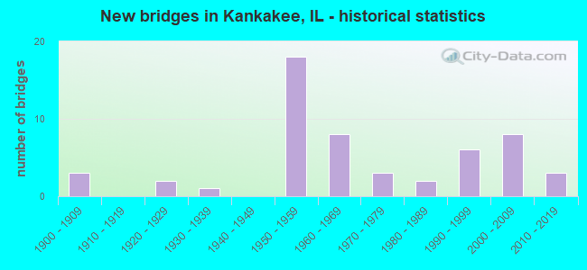
- New bridges - historical statistics
- 31900-1909
- 21920-1929
- 11930-1939
- 181950-1959
- 81960-1969
- 31970-1979
- 21980-1989
- 61990-1999
- 82000-2009
- 32010-2019
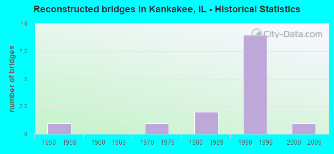
- Reconstructed bridges - Historical Statistics
- 11950-1959
- 01960-1969
- 11970-1979
- 21980-1989
- 91990-1999
- 12000-2009
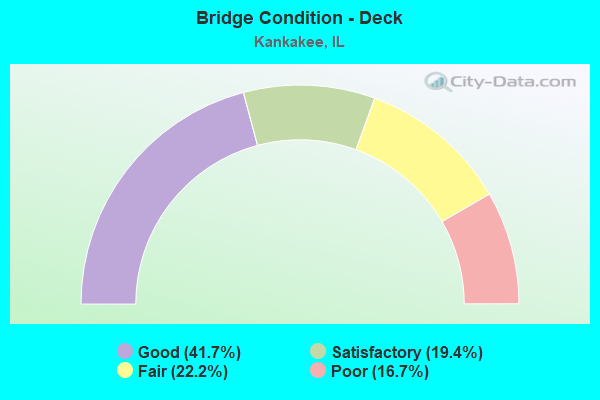
- Bridge Condition - Deck
- 41.7%Good
- 19.4%Satisfactory
- 22.2%Fair
- 16.7%Poor
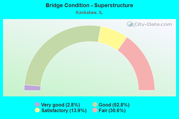
- Bridge Condition - Superstructure
- 2.8%Very good
- 52.8%Good
- 13.9%Satisfactory
- 30.6%Fair
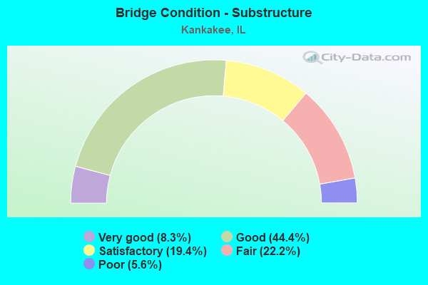
- Bridge Condition - Substructure
- 8.3%Very good
- 44.4%Good
- 19.4%Satisfactory
- 22.2%Fair
- 5.6%Poor
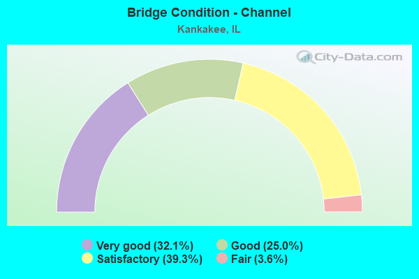
- Bridge Condition - Channel
- 32.1%Very good
- 25.0%Good
- 39.3%Satisfactory
- 3.6%Fair
Find on map >> Show street view
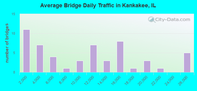
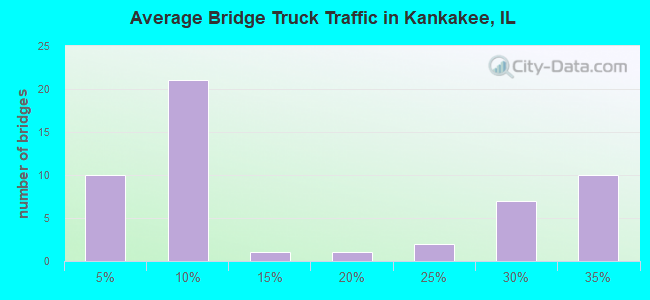
Structure Number: 460011, Location: 0.95 MI N ILL 17 (Lat: 41.133250, Lng: -87.835922), Route carried "under" structure: Other road , Year Built: 1954, Structure Length: 0. m, Average Daily Traffic: 2,700 (year 2021), Truck Traffic: 7%, Features Intersected: GRINNELL RD FAU 6221, Facility Carried by Structure: FAI-57 SB
Minimum Vertical Clearance: 5.38m (17.65ft), Kilometerpoint: 1.159, Lanes on structure: 2, Lanes under structure: 2, Material/Design: Steel continuous, Design/Construction: Stringer/Multi-beam, Length of Maximum Span: 13.7m (44.9ft)
Find on map >> Show street view
Structure Number: 460034, Location: 100 FT W US 45/52 (Lat: 41.121214, Lng: -87.878172), Route carried "under" structure: County highway , Year Built: 1957, Structure Length: 0. m, Average Daily Traffic: 125 (year 2021), Truck Traffic: 2%, Features Intersected: KKK RIVER & PK RD, Facility Carried by Structure: IL 17/FAP 41
Minimum Vertical Clearance: 3.81m (12.50ft), Kilometerpoint: 0.322, Lanes on structure: 7, Lanes under structure: 2, Material/Design: Steel continuous, Design/Construction: Stringer/Multi-beam, Length of Maximum Span: 38.1m (125.0ft)
Find on map >> Show street view
Structure Number: 46005, Location: KANKAKEE (Lat: 41.112031, Lng: -87.867464), Route carried "under" structure: US 45, Year Built: 1900, Structure Length: 0. m, Average Daily Traffic: 3,250 (year 2021), Truck Traffic: 3%, Features Intersected: WATER ST.US 45, Facility Carried by Structure: RR BRIDGE
Minimum Vertical Clearance: 3.86m (12.66ft), Kilometerpoint: 522.572, Lanes under structure: 2, Material/Design: Concrete, Design/Construction: Slab, Length of Maximum Span: 15.5m (50.9ft)
Find on map >> Show street view
Structure Number: 460052, Location: JCT I-57 & US 45&52 (Lat: 41.076581, Lng: -87.868711), Route carried "under" structure: Interstate 57, Year Built: 1962, Structure Length: 0. m, Average Daily Traffic: 24,600 (year 2019), Truck Traffic: 32%, Features Intersected: I-57, Facility Carried by Structure: US 45 & 52
Minimum Vertical Clearance: 4.95m (16.24ft), Kilometerpoint: 495.021, Lanes on structure: 4, Lanes under structure: 4, Material/Design: Steel continuous, Design/Construction: Stringer/Multi-beam, Length of Maximum Span: 20.7m (67.9ft)
Find on map >> Show street view
Structure Number: 46008, Location: 3.4 M N US 45&54 (Lat: 41.108069, Lng: -87.835150), Route carried "under" structure: Interstate 57, Year Built: 1953, Structure Length: 0. m, Average Daily Traffic: 24,600 (year 2019), Truck Traffic: 32%, Features Intersected: I-57, Facility Carried by Structure: WALDRON RDFAU 6184
Minimum Vertical Clearance: 5.00m (16.40ft), Kilometerpoint: 500.605, Lanes on structure: 2, Lanes under structure: 4, Material/Design: Steel continuous, Design/Construction: Stringer/Multi-beam, Length of Maximum Span: 19.3m (63.3ft)
Find on map >> Show street view
Structure Number: 460089, Location: 3.4 MI N CHEBANSE IN (Lat: 41.047586, Lng: -87.890886), Route carried "under" structure: Interstate 57, Year Built: 1968, Structure Length: 0. m, Average Daily Traffic: 20,500 (year 2019), Truck Traffic: 32%, Features Intersected: I-57 & I C G RR, Facility Carried by Structure: FAU 6223/OTTO RD
Minimum Vertical Clearance: 7.85m (25.75ft), Kilometerpoint: 491.062, Lanes on structure: 2, Lanes under structure: 4, Material/Design: Steel continuous, Design/Construction: Stringer/Multi-beam, Length of Maximum Span: 17.1m (56.1ft)
Find on map >> Show street view
Structure Number: 460093, Location: 3 BLOCKS N OF COURT (Lat: 41.124281, Lng: -87.878311), Route carried "under" structure: US 45, Year Built: 1960, Structure Length: 0. m, Average Daily Traffic: 18,400 (year 2021), Truck Traffic: 3%, Features Intersected: US 45-52, Facility Carried by Structure: CON-RAIL CORP.
Minimum Vertical Clearance: 4.78m (15.68ft), Kilometerpoint: 524.728, Lanes under structure: 4, Material/Design: Steel, Design/Construction: Girder and Floorbeam System, Length of Maximum Span: 21.0m (68.9ft)
Find on map >> Show street view
Structure Number: 460094, Location: KANKAKEE (Lat: 41.114192, Lng: -87.866967), Route carried "under" structure: Other road , Year Built: 1900, Structure Length: 0. m, Average Daily Traffic: 3,950 (year 2021), Truck Traffic: 7%, Features Intersected: US45 &52 RIVER ST, Facility Carried by Structure: IC RR
Minimum Vertical Clearance: 4.29m (14.07ft), Kilometerpoint: 0.161, Lanes under structure: 2, Material/Design: Concrete, Length of Maximum Span: 31.1m (102.0ft)
Find on map >> Show street view
Structure Number: 460113, Location: 2.3 ML N OF 45 & 52 (Lat: 41.091550, Lng: -87.834531), Route carried "under" structure: Interstate 57, Year Built: 1993, Structure Length: 0. m, Average Daily Traffic: 24,600 (year 2019), Truck Traffic: 32%, Features Intersected: I 57, Facility Carried by Structure: FAU 6189/RIVER RD
Minimum Vertical Clearance: 5.11m (16.77ft), Kilometerpoint: 498.770, Lanes on structure: 2, Lanes under structure: 2, Material/Design: Steel continuous, Design/Construction: Stringer/Multi-beam, Length of Maximum Span: 47.2m (154.9ft)
Find on map >> Show street view
Structure Number: 46304, Location: N120-E045 (Lat: 41.135483, Lng: -87.862569), Route carried "under" structure: Other road , Year Built: 1925, Structure Length: 0. m, Average Daily Traffic: 9,000 (year 2021), Truck Traffic: 3%, Features Intersected: BROOKMOUNT BLVD, Facility Carried by Structure: IC RR
Minimum Vertical Clearance: 3.73m (12.24ft), Kilometerpoint: 1.223, Lanes under structure: 2, Material/Design: Concrete, Design/Construction: Slab, Length of Maximum Span: 5.5m (18.0ft)
Find on map >> Show street view
Structure Number: 466901, Location: KANKAKEE SOUTH SIDE (Lat: 41.109136, Lng: -87.868339), Route carried "under" structure: City street , Year Built: 1900, Structure Length: 0. m, Average Daily Traffic: 350 (year 2021), Truck Traffic: 3%, Features Intersected: HAWKINS STMS # 2500, Facility Carried by Structure: ICG RR
Minimum Vertical Clearance: 4.01m (13.16ft), Kilometerpoint: 1.062, Lanes under structure: 2, Material/Design: Prestressed concrete, Design/Construction: Slab, Length of Maximum Span: 6.1m (20.0ft)
Find on map >> Show street view
Structure Number: 469801, Location: 0.2 M. N. of IL 17 (Lat: 41.123986, Lng: -87.882558), Route carried "under" structure: State highway 113, Year Built: 2002, Structure Length: 0. m, Average Daily Traffic: 11,100 (year 2021), Truck Traffic: 5%, Features Intersected: IL 113, Facility Carried by Structure: Pedestrian Bridge
Minimum Vertical Clearance: 5.23m (17.16ft), Kilometerpoint: 54.185, Lanes under structure: 4, Material/Design: Steel continuous, Length of Maximum Span: 25.6m (84.0ft)
Find on map >> Show street view
Structure Number: 469903, Location: 0.1 MI N OF ILL 17 (Lat: 41.123011, Lng: -87.881939), Route carried "under" structure: State highway 113, Year Built: 2004, Structure Length: 0. m, Average Daily Traffic: 11,100 (year 2021), Truck Traffic: 5%, Features Intersected: ILL 113, Facility Carried by Structure: CON-RAIL CORP.
Minimum Vertical Clearance: 4.75m (15.58ft), Kilometerpoint: 54.298, Lanes under structure: 2, Material/Design: Steel, Design/Construction: Girder and Floorbeam System, Length of Maximum Span: 33.5m (109.9ft)