Bridge Statistics for Kendall, Florida (FL)
Condition, Traffic, Stress, Structural Evaluation, Project Costs
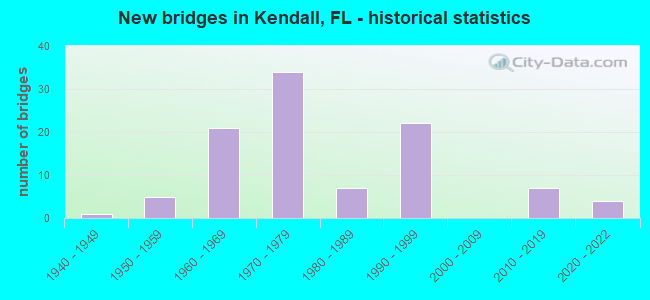
- New bridges - historical statistics
- 11940-1949
- 51950-1959
- 211960-1969
- 341970-1979
- 71980-1989
- 221990-1999
- 72010-2019
- 42020-2022

- Reconstructed bridges - Historical Statistics
- 21970-1979
- 31980-1989
- 21990-1999
- 42000-2009
- 22010-2019
- 12020-2022


- Bridge Condition - Deck
- 3.1%Excellent
- 26.2%Very good
- 61.5%Good
- 3.1%Satisfactory
- 4.6%Fair
- 1.5%Poor

- Bridge Condition - Superstructure
- 3.1%Excellent
- 32.3%Very good
- 55.4%Good
- 1.5%Satisfactory
- 6.2%Fair
- 1.5%Poor

- Bridge Condition - Substructure
- 6.2%Excellent
- 18.5%Very good
- 67.7%Good
- 6.2%Satisfactory
- 1.5%Fair

- Bridge Condition - Channel
- 2.2%Excellent
- 8.9%Very good
- 28.9%Good
- 28.9%Satisfactory
- 31.1%Fair
Find on map >> Show street view
Structure Number: 874221, Location: 0.2 Miles S of SW 56th St (Lat: 25.711417, Lng: -80.396861), Route carried "on" structure: County highway , Year Built: 1970, Status: Open, Structure Length: 1.04m (3.41ft), Average Daily Traffic: 520 (year 1999), Truck Traffic: 1%, Average Future Daily Traffic: 903 (year 2039), Design Load: H 20, Features Intersected: SW 60th St. Ext. Canal, Facility Carried by Structure: SW 125th Avenue
Minimum Vertical Clearance: 30+ m (98+ ft), Kilometerpoint: 1.905, Lanes on structure: 2, Owner: County Highway Agency, Approaching Roadway Width: 6.4m (21.0ft), Material/Design: Prestressed concrete, Design/Construction: Slab, Number Of Spans In Main Unit: 1, Length of Maximum Span: 10.4m (34.1ft), Curb or Sidewalk Widths: Left: 1.2m (3.9ft), Right: 1.2m (3.9ft), Curb-To-Curb Width: 7.9m (25.9ft), Out-to-Out Width: 11.0m (36.1ft)
Condition: Deck: Good, Superstructure: Good, Substructure: Good, Channel: Fair, Operating Rating: 40.7 metric tons, Method Used To Determine Operating Rating: Load Factor (LF), Inventory Rating: 24.4 metric tons, Method Used To Determine Inventory Rating: Load Factor (LF), Structural Evaluation: Equal to present minimum criteria, Deck Geometry: Somewhat better than minimum adequacy, Waterway Adequacy: Better than present minimum criteria, Approach Roadway Alignment: Equal to present desirable criteria, Designated Inspection Frequency: Every 24 months, Inspection Date: March 2020, Deck Structure Type: Concrete Precast Panels, Wearing Surface/Protective System: Wearing Surface: Bituminous
Find on map >> Show street view
Structure Number: 874222, Location: At SW 117th Ave. (Lat: 25.714889, Lng: -80.382972), Route carried "on" structure: City street , Year Built: 1988, Status: Open, Structure Length: 3.13m (10.27ft), Average Daily Traffic: 28,500 (year 2019), Truck Traffic: 10%, Average Future Daily Traffic: 51,793 (year 2041), Design Load: HS 20, Features Intersected: Snapper Creek Canal, Facility Carried by Structure: SW 56th Street
Minimum Vertical Clearance: 30+ m (98+ ft), Kilometerpoint: 0.045, Lanes on structure: 6, Owner: County Highway Agency, Approaching Roadway Width: 24.5m (80.4ft), Skew: 21 degrees, Material/Design: Prestressed concrete, Design/Construction: Slab, Number Of Spans In Main Unit: 3, Length of Maximum Span: 10.5m (34.4ft), Curb or Sidewalk Widths: Left: 4.0m (13.1ft), Right: 1.5m (4.9ft), Curb-To-Curb Width: 24.5m (80.4ft), Out-to-Out Width: 31.3m (102.7ft)
Condition: Deck: Very good, Superstructure: Very good, Substructure: Satisfactory, Channel: Fair, Operating Rating: 46.8 metric tons, Method Used To Determine Operating Rating: Load Factor (LF), Inventory Rating: 28.0 metric tons, Method Used To Determine Inventory Rating: Load Factor (LF), Structural Evaluation: Equal to present minimum criteria, Deck Geometry: Somewhat better than minimum adequacy, Waterway Adequacy: Equal to present desirable criteria, Approach Roadway Alignment: Equal to present desirable criteria, Designated Inspection Frequency: Every 24 months, Underwater Inspection Frequency: Every 24 months, Inspection Date: November 2020, Underwater Inspection Date: November 2020, Deck Structure Type: Concrete Precast Panels, Wearing Surface/Protective System: Wearing Surface: Bituminous
Find on map >> Show street view
Structure Number: 874223, Location: 0.2 Mile S of SW 56th St. (Lat: 25.711542, Lng: -80.392847), Route carried "on" structure: County highway , Year Built: 1970, Status: Open, Structure Length: 1.04m (3.41ft), Average Daily Traffic: 1,270 (year 2014), Truck Traffic: 2%, Average Future Daily Traffic: 2,205 (year 2039), Design Load: H 20, Features Intersected: SW 60th St. Ext. Canal, Facility Carried by Structure: SW 123rd Avenue
Minimum Vertical Clearance: 30+ m (98+ ft), Kilometerpoint: 1.205, Lanes on structure: 2, Owner: County Highway Agency, Approaching Roadway Width: 7.0m (23.0ft), Material/Design: Prestressed concrete, Design/Construction: Slab, Number Of Spans In Main Unit: 1, Length of Maximum Span: 10.4m (34.1ft), Curb or Sidewalk Widths: Left: 1.2m (3.9ft), Right: 1.2m (3.9ft), Curb-To-Curb Width: 7.9m (25.9ft), Out-to-Out Width: 10.9m (35.8ft)
Condition: Deck: Good, Superstructure: Good, Substructure: Good, Channel: Fair, Operating Rating: 40.7 metric tons, Method Used To Determine Operating Rating: Load Factor (LF), Inventory Rating: 24.4 metric tons, Method Used To Determine Inventory Rating: Load Factor (LF), Structural Evaluation: Equal to present minimum criteria, Deck Geometry: Meets minimum limits, Waterway Adequacy: Better than present minimum criteria, Approach Roadway Alignment: Equal to present desirable criteria, Designated Inspection Frequency: Every 24 months, Inspection Date: March 2020, Deck Structure Type: Concrete Precast Panels, Wearing Surface/Protective System: Wearing Surface: Bituminous
Find on map >> Show street view
Structure Number: 874224, Location: 0.2 Mile S of SW 56th St. (Lat: 25.711661, Lng: -80.388839), Route carried "on" structure: County highway , Year Built: 1970, Status: Open, Structure Length: 1.04m (3.41ft), Average Daily Traffic: 1,851 (year 2014), Truck Traffic: 2%, Average Future Daily Traffic: 3,212 (year 2038), Design Load: HS 20, Features Intersected: SW 60th St. Ext. Canal, Facility Carried by Structure: SW 120th Avenue
Minimum Vertical Clearance: 30+ m (98+ ft), Kilometerpoint: 1.207, Lanes on structure: 2, Owner: County Highway Agency, Approaching Roadway Width: 7.3m (24.0ft), Material/Design: Prestressed concrete, Design/Construction: Slab, Number Of Spans In Main Unit: 1, Length of Maximum Span: 10.4m (34.1ft), Curb or Sidewalk Widths: Left: 1.2m (3.9ft), Right: 1.2m (3.9ft), Curb-To-Curb Width: 7.9m (25.9ft), Out-to-Out Width: 11.0m (36.1ft)
Condition: Deck: Good, Superstructure: Good, Substructure: Good, Channel: Fair, Operating Rating: 48.4 metric tons, Method Used To Determine Operating Rating: Load Factor (LF), Inventory Rating: 29.0 metric tons, Method Used To Determine Inventory Rating: Load Factor (LF), Structural Evaluation: Better than present minimum criteria, Deck Geometry: Meets minimum limits, Waterway Adequacy: Better than present minimum criteria, Approach Roadway Alignment: Equal to present desirable criteria, Designated Inspection Frequency: Every 24 months, Inspection Date: March 2020, Deck Structure Type: Concrete Precast Panels, Wearing Surface/Protective System: Wearing Surface: Bituminous
Find on map >> Show street view
Structure Number: 874247, Location: 0.3 Mile N of SW 56th St. (Lat: 25.719639, Lng: -80.375147), Route carried "on" structure: City street , Year Built: 1957, Status: Open, Structure Length: 1.59m (5.22ft), Average Daily Traffic: 8,084 (year 2014), Truck Traffic: 2%, Average Future Daily Traffic: 14,025 (year 2039), Design Load: HS 20, Features Intersected: Miller Road Canal, Facility Carried by Structure: SW 112th Avenue
Minimum Vertical Clearance: 30+ m (98+ ft), Kilometerpoint: 1.463, Lanes on structure: 2, Owner: County Highway Agency, Approaching Roadway Width: 8.1m (26.6ft), Material/Design: Prestressed concrete, Design/Construction: Stringer/Multi-beam, Number Of Spans In Main Unit: 1, Length of Maximum Span: 15.9m (52.2ft), Curb or Sidewalk Widths: Left: 0.7m (2.3ft), Right: 0.7m (2.3ft), Curb-To-Curb Width: 8.1m (26.6ft), Out-to-Out Width: 9.7m (31.8ft)
Condition: Deck: Good, Superstructure: Good, Substructure: Satisfactory, Channel: Satisfactory, Operating Rating: 75.1 metric tons, Method Used To Determine Operating Rating: Load Factor (LF), Inventory Rating: 45.1 metric tons, Method Used To Determine Inventory Rating: Load Factor (LF), Structural Evaluation: Equal to present minimum criteria, Deck Geometry: High priority of replacement, Waterway Adequacy: Equal to present desirable criteria, Approach Roadway Alignment: Somewhat better than minimum adequacy, Designated Inspection Frequency: Every 24 months, Inspection Date: April 2020, Deck Structure Type: Concrete Cast-file-Place, Wearing Surface/Protective System: Wearing Surface: Monolithic Concrete
Find on map >> Show street view
Structure Number: 874248, Location: 0.2Mile W of SW 107th Ave (Lat: 25.723111, Lng: -80.371278), Route carried "on" structure: County highway , Year Built: 1960, Status: Open, Structure Length: 1.87m (6.14ft), Average Daily Traffic: 4,682 (year 2014), Truck Traffic: 2%, Average Future Daily Traffic: 7,964 (year 2039), Design Load: HS 20, Features Intersected: Westwood Lakes, Facility Carried by Structure: SW 47th Terrace
Minimum Vertical Clearance: 30+ m (98+ ft), Kilometerpoint: 1.157, Lanes on structure: 2, Owner: County Highway Agency, Approaching Roadway Width: 5.2m (17.1ft), Material/Design: Prestressed concrete, Design/Construction: Stringer/Multi-beam, Number Of Spans In Main Unit: 1, Length of Maximum Span: 18.7m (61.4ft), Curb or Sidewalk Widths: Left: 0.8m (2.6ft), Right: 0.8m (2.6ft), Curb-To-Curb Width: 7.0m (23.0ft), Out-to-Out Width: 8.6m (28.2ft)
Condition: Deck: Good, Superstructure: Very good, Substructure: Satisfactory, Channel: Fair, Operating Rating: 49.7 metric tons, Method Used To Determine Operating Rating: Load Factor (LF), Inventory Rating: 29.8 metric tons, Method Used To Determine Inventory Rating: Load Factor (LF), Structural Evaluation: Equal to present minimum criteria, Deck Geometry: High priority of replacement, Waterway Adequacy: Equal to present desirable criteria, Approach Roadway Alignment: Equal to present minimum criteria, Designated Inspection Frequency: Every 24 months, Inspection Date: May 2020, Deck Structure Type: Concrete Cast-file-Place, Wearing Surface/Protective System: Wearing Surface: Monolithic Concrete
Find on map >> Show street view
Structure Number: 874255, Location: 75Ft. S of Snapper Crk Dr (Lat: 25.695853, Lng: -80.354686), Route carried "on" structure: County highway , Year Built: 1960, Status: Open, Structure Length: 3.12m (10.24ft), Average Daily Traffic: 9,504 (year 2020), Truck Traffic: 3%, Average Future Daily Traffic: 16,057 (year 2042), Design Load: HS 20, Features Intersected: Snapper Creek Canal, Facility Carried by Structure: SW 99th Avenue
Minimum Vertical Clearance: 30.45m (99.90ft), Kilometerpoint: 0.829, Lanes on structure: 2, Owner: County Highway Agency, Approaching Roadway Width: 7.3m (24.0ft), Material/Design: Prestressed concrete, Design/Construction: Slab, Number Of Spans In Main Unit: 3, Length of Maximum Span: 10.5m (34.4ft), Curb or Sidewalk Widths: Left: 1.2m (3.9ft), Right: 1.2m (3.9ft), Curb-To-Curb Width: 8.0m (26.2ft), Out-to-Out Width: 11.1m (36.4ft)
Condition: Deck: Fair, Superstructure: Fair, Substructure: Good, Channel: Fair, Operating Rating: 48.6 metric tons, Method Used To Determine Operating Rating: Load Factor (LF), Inventory Rating: 29.1 metric tons, Method Used To Determine Inventory Rating: Load Factor (LF), Structural Evaluation: Somewhat better than minimum adequacy, Deck Geometry: High priority of replacement, Waterway Adequacy: Better than present minimum criteria, Approach Roadway Alignment: Better than present minimum criteria, Designated Inspection Frequency: Every 24 months, Underwater Inspection Frequency: Every 24 months, Inspection Date: August 2021, Underwater Inspection Date: August 2021, Deck Structure Type: Concrete Precast Panels, Wearing Surface/Protective System: Wearing Surface: Bituminous
Find on map >> Show street view
Structure Number: 874256, Location: 800Ft. N of SW 88th St. (Lat: 25.688781, Lng: -80.383153), Route carried "on" structure: County highway , Year Built: 1985, Status: Open, Structure Length: 6.26m (20.54ft), Average Daily Traffic: 39,107 (year 2020), Truck Traffic: 4%, Average Future Daily Traffic: 64,025 (year 2042), Design Load: HS 20, Features Intersected: Town and Country Lake, Facility Carried by Structure: SW 117th Ave.
Minimum Vertical Clearance: 30+ m (98+ ft), Kilometerpoint: 1.883, Lanes on structure: 4, Owner: County Highway Agency, Approaching Roadway Width: 6.8m (22.3ft), Skew: 20 degrees, Material/Design: Prestressed concrete, Design/Construction: Slab, Number Of Spans In Main Unit: 6, Length of Maximum Span: 10.7m (35.1ft), Curb or Sidewalk Widths: Left: 1.5m (4.9ft), Right: 1.5m (4.9ft), Curb-To-Curb Width: 30.5m (100.1ft), Out-to-Out Width: 34.8m (114.2ft)
Condition: Deck: Good, Superstructure: Satisfactory, Substructure: Good, Channel: Good, Operating Rating: 49.9 metric tons, Method Used To Determine Operating Rating: Load Factor (LF), Inventory Rating: 29.8 metric tons, Method Used To Determine Inventory Rating: Load Factor (LF), Structural Evaluation: Equal to present minimum criteria, Deck Geometry: Superior to present desirable criteria, Waterway Adequacy: Better than present minimum criteria, Approach Roadway Alignment: Equal to present desirable criteria, Designated Inspection Frequency: Every 24 months, Underwater Inspection Frequency: Every 24 months, Inspection Date: November 2020, Underwater Inspection Date: November 2020, Deck Structure Type: Concrete Precast Panels, Wearing Surface/Protective System: Wearing Surface: Bituminous
Find on map >> Show street view
Structure Number: 874257, Location: 700Ft. N of SW 86th St. (Lat: 25.692222, Lng: -80.317472), Route carried "on" structure: County highway , Year Built: 1965, Status: Open, Structure Length: 3.11m (10.20ft), Average Daily Traffic: 1,989 (year 2020), Truck Traffic: 3%, Average Future Daily Traffic: 3,281 (year 2042), Design Load: HS 20, Features Intersected: Snapper Creek Canal, Facility Carried by Structure: SW 77th Avenue
Minimum Vertical Clearance: 30+ m (98+ ft), Kilometerpoint: 0.604, Lanes on structure: 2, Owner: County Highway Agency, Approaching Roadway Width: 7.4m (24.3ft), Material/Design: Prestressed concrete, Design/Construction: Slab, Number Of Spans In Main Unit: 3, Length of Maximum Span: 10.4m (34.1ft), Curb or Sidewalk Widths: Left: 0.6m (2.0ft), Right: 1.2m (3.9ft), Curb-To-Curb Width: 8.6m (28.2ft), Out-to-Out Width: 11.2m (36.7ft)
Condition: Deck: Good, Superstructure: Good, Substructure: Good, Channel: Satisfactory, Operating Rating: 59.1 metric tons, Method Used To Determine Operating Rating: Load Factor (LF), Inventory Rating: 41.7 metric tons, Method Used To Determine Inventory Rating: Load Factor (LF), Structural Evaluation: Better than present minimum criteria, Deck Geometry: Somewhat better than minimum adequacy, Waterway Adequacy: Equal to present minimum criteria, Approach Roadway Alignment: Equal to present desirable criteria, Designated Inspection Frequency: Every 24 months, Underwater Inspection Frequency: Every 24 months, Inspection Date: August 2021, Underwater Inspection Date: August 2021, Deck Structure Type: Concrete Precast Panels, Wearing Surface/Protective System: Wearing Surface: Bituminous
Find on map >> Show street view
Structure Number: 874258, Location: 0.3 Mile N of 88th Street (Lat: 25.692106, Lng: -80.321539), Route carried "on" structure: County highway , Year Built: 1971, Status: Open, Structure Length: 4.27m (14.01ft), Average Daily Traffic: 4,916 (year 2020), Truck Traffic: 5%, Average Future Daily Traffic: 7,964 (year 2042), Design Load: HS 20, Features Intersected: Snapper Creek Canal, Facility Carried by Structure: SW 79th Avenue
Minimum Vertical Clearance: 30+ m (98+ ft), Kilometerpoint: 1.424, Lanes on structure: 2, Owner: County Highway Agency, Approaching Roadway Width: 7.0m (23.0ft), Material/Design: Prestressed concrete, Design/Construction: Slab, Number Of Spans In Main Unit: 5, Length of Maximum Span: 9.2m (30.2ft), Curb or Sidewalk Widths: Left: 1.2m (3.9ft), Right: 1.2m (3.9ft), Curb-To-Curb Width: 8.5m (27.9ft), Out-to-Out Width: 11.6m (38.1ft)
Condition: Deck: Poor, Superstructure: Poor, Substructure: Good, Channel: Fair, Operating Rating: 47.8 metric tons, Method Used To Determine Operating Rating: Load Factor (LF), Inventory Rating: 28.6 metric tons, Method Used To Determine Inventory Rating: Load Factor (LF), Structural Evaluation: Meets minimum limits, Deck Geometry: Meets minimum limits, Waterway Adequacy: Equal to present minimum criteria, Approach Roadway Alignment: Better than present minimum criteria, Designated Inspection Frequency: Every 24 months, Underwater Inspection Frequency: Every 24 months, Other Special Inspection Frequency: Every 12 months, Inspection Date: June 2020, Underwater Inspection Date: June 2020, Other Special Inspection Date: June 2021, Deck Structure Type: Concrete Precast Panels, Wearing Surface/Protective System: Wearing Surface: Bituminous
Find on map >> Show street view
Structure Number: 874343, Location: 0.1 Mile S of 36th Street (Lat: 25.644333, Lng: -80.341222), Route carried "on" structure: County highway , Year Built: 1972, Status: Open, Structure Length: 0.76m (2.49ft), Average Daily Traffic: 4,202 (year 2020), Truck Traffic: 2%, Average Future Daily Traffic: 7,079 (year 2042), Design Load: HS 20, Features Intersected: Canal C-100-C, Facility Carried by Structure: SW 92nd Ave
Minimum Vertical Clearance: 30+ m (98+ ft), Kilometerpoint: 1.741, Lanes on structure: 4, Owner: County Highway Agency, Approaching Roadway Width: 20.4m (66.9ft), Skew: 22 degrees, Material/Design: Steel, Design/Construction: Culvert, Number Of Spans In Main Unit: 1, Length of Maximum Span: 7.6m (24.9ft)
Condition: Channel: Fair, Culverts: Good, Operating Rating: 64.0 metric tons, Method Used To Determine Operating Rating: Load Factor (LF), Inventory Rating: 45.1 metric tons, Method Used To Determine Inventory Rating: Load Factor (LF), Structural Evaluation: Better than present minimum criteria, Waterway Adequacy: Equal to present desirable criteria, Approach Roadway Alignment: Equal to present desirable criteria, Designated Inspection Frequency: Every 24 months, Underwater Inspection Frequency: Every 24 months, Inspection Date: June 2020, Underwater Inspection Date: June 2020
Find on map >> Show street view
Structure Number: 874384, Location: 200 Ft. N of SW 80th St. (Lat: 25.694814, Lng: -80.359175), Route carried "on" structure: City street , Year Built: 1970, Status: Open, Structure Length: 2.52m (8.27ft), Average Daily Traffic: 2,683 (year 2020), Truck Traffic: 1%, Average Future Daily Traffic: 3,570 (year 2042), Design Load: HL 93, Features Intersected: Sunset Park Canal, Facility Carried by Structure: SW 102nd Place
Minimum Vertical Clearance: 30+ m (98+ ft), Kilometerpoint: 0.935, Lanes on structure: 2, Owner: County Highway Agency, Approaching Roadway Width: 7.7m (25.3ft), Material/Design: Prestressed concrete, Design/Construction: Slab, Number Of Spans In Main Unit: 3, Length of Maximum Span: 8.4m (27.6ft), Curb or Sidewalk Widths: Left: 1.2m (3.9ft), Right: 1.2m (3.9ft), Curb-To-Curb Width: 9.9m (32.5ft), Out-to-Out Width: 11.1m (36.4ft)
Condition: Deck: Good, Superstructure: Good, Substructure: Good, Channel: Satisfactory, Operating Rating: 59.1 metric tons, Method Used To Determine Operating Rating: Load and Resistance Factor (LRFR), Inventory Rating: 45.6 metric tons, Method Used To Determine Inventory Rating: Load and Resistance Factor (LRFR), Structural Evaluation: Better than present minimum criteria, Deck Geometry: Meets minimum limits, Waterway Adequacy: Better than present minimum criteria, Approach Roadway Alignment: Equal to present desirable criteria, Designated Inspection Frequency: Every 24 months, Underwater Inspection Frequency: Every 24 months, Inspection Date: March 2020, Underwater Inspection Date: March 2020, Deck Structure Type: Concrete Precast Panels, Wearing Surface/Protective System: Wearing Surface: Bituminous
Find on map >> Show street view
Structure Number: 874416, Location: 450Ft. S of SW 128th St. (Lat: 25.649561, Lng: -80.350556), Route carried "on" structure: County highway , Year Built: 1966, Status: Open, Structure Length: 2.45m (8.04ft), Average Daily Traffic: 6,058 (year 2020), Truck Traffic: 2%, Average Future Daily Traffic: 27,870 (year 2042), Design Load: HL 93, Features Intersected: Canal C-100-C, Facility Carried by Structure: SW 97th Avenue
Minimum Vertical Clearance: 30+ m (98+ ft), Kilometerpoint: 1.477, Lanes on structure: 2, Owner: County Highway Agency, Approaching Roadway Width: 7.3m (24.0ft), Material/Design: Prestressed concrete, Design/Construction: Slab, Number Of Spans In Main Unit: 3, Length of Maximum Span: 8.2m (26.9ft), Curb or Sidewalk Widths: Left: 1.2m (3.9ft), Right: 1.2m (3.9ft), Curb-To-Curb Width: 8.6m (28.2ft), Out-to-Out Width: 11.5m (37.7ft)
Condition: Deck: Good, Superstructure: Good, Substructure: Good, Channel: Good, Operating Rating: 54.2 metric tons, Method Used To Determine Operating Rating: Load and Resistance Factor (LRFR), Inventory Rating: 41.9 metric tons, Method Used To Determine Inventory Rating: Load and Resistance Factor (LRFR), Structural Evaluation: Better than present minimum criteria, Deck Geometry: High priority of replacement, Waterway Adequacy: Better than present minimum criteria, Approach Roadway Alignment: Equal to present desirable criteria, Designated Inspection Frequency: Every 24 months, Underwater Inspection Frequency: Every 24 months, Inspection Date: March 2020, Underwater Inspection Date: March 2020, Deck Structure Type: Concrete Precast Panels, Wearing Surface/Protective System: Wearing Surface: Bituminous
Find on map >> Show street view
Structure Number: 874419, Location: 20Ft. E of SW 71st Avenue (Lat: 25.655772, Lng: -80.308869), Route carried "on" structure: County highway , Year Built: 1965, Status: Open, Structure Length: 2.00m (6.56ft), Average Daily Traffic: 3,618 (year 2020), Truck Traffic: 2%, Average Future Daily Traffic: 4,080 (year 2042), Design Load: HS 20, Features Intersected: Canal C-100-A, Facility Carried by Structure: SW 124th Street
Minimum Vertical Clearance: 30+ m (98+ ft), Kilometerpoint: 2.580, Lanes on structure: 2, Owner: City or Municipal Highway Agency, Approaching Roadway Width: 6.7m (22.0ft), Skew: 3 degrees, Material/Design: Prestressed concrete, Design/Construction: Slab, Number Of Spans In Main Unit: 3, Length of Maximum Span: 9.2m (30.2ft), Curb or Sidewalk Widths: Left: 1.2m (3.9ft), Right: 1.2m (3.9ft), Curb-To-Curb Width: 8.6m (28.2ft), Out-to-Out Width: 11.7m (38.4ft)
Condition: Deck: Good, Superstructure: Good, Substructure: Good, Channel: Good, Operating Rating: 53.0 metric tons, Method Used To Determine Operating Rating: Load Factor (LF), Inventory Rating: 33.7 metric tons, Method Used To Determine Inventory Rating: Load Factor (LF), Structural Evaluation: Better than present minimum criteria, Deck Geometry: Meets minimum limits, Waterway Adequacy: Better than present minimum criteria, Approach Roadway Alignment: Equal to present desirable criteria, Designated Inspection Frequency: Every 24 months, Underwater Inspection Frequency: Every 24 months, Inspection Date: March 2020, Underwater Inspection Date: March 2020, Deck Structure Type: Concrete Precast Panels, Wearing Surface/Protective System: Wearing Surface: Bituminous
Find on map >> Show street view
Structure Number: 87442, Location: 500Ft E of SW 72nd Ave. (Lat: 25.644583, Lng: -80.308194), Route carried "on" structure: County highway , Year Built: 1966, Status: Open, Structure Length: 1.83m (6.00ft), Average Daily Traffic: 12,056 (year 2014), Truck Traffic: 5%, Average Future Daily Traffic: 13,260 (year 2036), Design Load: HS 20, Features Intersected: Canal C-100-A, Facility Carried by Structure: SW 136th Street
Minimum Vertical Clearance: 30+ m (98+ ft), Kilometerpoint: 2.604, Lanes on structure: 2, Owner: County Highway Agency, Approaching Roadway Width: 7.3m (24.0ft), Material/Design: Prestressed concrete, Design/Construction: Slab, Number Of Spans In Main Unit: 2, Length of Maximum Span: 9.1m (29.9ft), Curb or Sidewalk Widths: Left: 1.2m (3.9ft), Right: 1.2m (3.9ft), Curb-To-Curb Width: 8.6m (28.2ft), Out-to-Out Width: 11.7m (38.4ft)
Condition: Deck: Fair, Superstructure: Fair, Substructure: Good, Channel: Satisfactory, Operating Rating: 64.9 metric tons, Method Used To Determine Operating Rating: Load Factor (LF), Inventory Rating: 38.7 metric tons, Method Used To Determine Inventory Rating: Load Factor (LF), Structural Evaluation: Somewhat better than minimum adequacy, Deck Geometry: High priority of replacement, Waterway Adequacy: Equal to present desirable criteria, Approach Roadway Alignment: Equal to present desirable criteria, Designated Inspection Frequency: Every 24 months, Underwater Inspection Frequency: Every 24 months, Inspection Date: Febuary 2020, Underwater Inspection Date: Febuary 2020, Deck Structure Type: Concrete Precast Panels, Wearing Surface/Protective System: Wearing Surface: Bituminous
Find on map >> Show street view
Structure Number: 874436, Location: 0.1Mile W of SW 107th Ave (Lat: 25.702556, Lng: -80.367111), Route carried "on" structure: County highway , Year Built: 1960, Status: Open, Structure Length: 0.64m (2.10ft), Average Daily Traffic: 6,242 (year 2014), Truck Traffic: 1%, Average Future Daily Traffic: 12,484 (year 2039), Design Load: HS 20, Features Intersected: SW 109th Avenue Canal, Facility Carried by Structure: N Snapper Creek Dr
Minimum Vertical Clearance: 30+ m (98+ ft), Kilometerpoint: 0.319, Lanes on structure: 2, Owner: County Highway Agency, Approaching Roadway Width: 7.5m (24.6ft), Material/Design: Concrete, Design/Construction: Slab, Number Of Spans In Main Unit: 1, Length of Maximum Span: 6.4m (21.0ft), Curb or Sidewalk Widths: Left: 1.2m (3.9ft), Right: 1.2m (3.9ft), Curb-To-Curb Width: 7.6m (24.9ft), Out-to-Out Width: 10.7m (35.1ft)
Condition: Deck: Good, Superstructure: Good, Substructure: Very good, Channel: Good, Operating Rating: 56.2 metric tons, Method Used To Determine Operating Rating: Load Factor (LF), Inventory Rating: 33.7 metric tons, Method Used To Determine Inventory Rating: Load Factor (LF), Structural Evaluation: Better than present minimum criteria, Deck Geometry: High priority of replacement, Waterway Adequacy: Equal to present minimum criteria, Approach Roadway Alignment: Equal to present desirable criteria, Designated Inspection Frequency: Every 24 months, Inspection Date: May 2020, Deck Structure Type: Concrete Cast-file-Place, Wearing Surface/Protective System: Wearing Surface: Monolithic Concrete
Find on map >> Show street view
Structure Number: 874438, Location: 1 mile E/O SW 97th Ave (Lat: 25.644556, Lng: -80.345389), Route carried "on" structure: County highway , Year Built: 1972, Status: Open, Structure Length: 1.01m (3.31ft), Average Daily Traffic: 17,299 (year 2020), Truck Traffic: 1%, Average Future Daily Traffic: 13,312 (year 2042), Design Load: HS 20, Features Intersected: Canal C-100-C, Facility Carried by Structure: SW 136th St
Minimum Vertical Clearance: 30+ m (98+ ft), Kilometerpoint: 1.376, Lanes on structure: 5, Owner: County Highway Agency, Approaching Roadway Width: 33.8m (110.9ft), Skew: 25 degrees, Material/Design: Steel, Design/Construction: Culvert, Number Of Spans In Main Unit: 1, Length of Maximum Span: 10.1m (33.1ft), Curb or Sidewalk Widths: Left: 2.1m (6.9ft), Right: 2.1m (6.9ft), Curb-To-Curb Width: 33.8m (110.9ft), Out-to-Out Width: 34.4m (112.9ft)
Condition: Channel: Fair, Culverts: Good, Operating Rating: 39.9 metric tons, Method Used To Determine Operating Rating: Load Factor (LF), Inventory Rating: 27.0 metric tons, Method Used To Determine Inventory Rating: Load Factor (LF), Structural Evaluation: Equal to present minimum criteria, Deck Geometry: Superior to present desirable criteria, Waterway Adequacy: Equal to present desirable criteria, Approach Roadway Alignment: Better than present minimum criteria, Designated Inspection Frequency: Every 24 months, Underwater Inspection Frequency: Every 24 months, Inspection Date: July 2020, Underwater Inspection Date: July 2020, Wearing Surface/Protective System: Wearing Surface: Bituminous
Find on map >> Show street view
Structure Number: 874439, Location: At SW 85th Street (Lat: 25.692103, Lng: -80.309233), Route carried "on" structure: City street , Year Built: 1967, Year Reconstructed: 1980, Status: Open, Structure Length: 4.82m (15.81ft), Average Daily Traffic: 20,869 (year 2020), Truck Traffic: 5%, Average Future Daily Traffic: 33,660 (year 2042), Design Load: HS 20, Features Intersected: Snapper Creek, Facility Carried by Structure: SW 72nd Avenue
Minimum Vertical Clearance: 30+ m (98+ ft), Kilometerpoint: 0.016, Lanes on structure: 4, Owner: County Highway Agency, Approaching Roadway Width: 15.8m (51.8ft), Material/Design: Prestressed concrete, Design/Construction: Slab, Number Of Spans In Main Unit: 5, Length of Maximum Span: 11.8m (38.7ft), Curb or Sidewalk Widths: Left: 2.3m (7.5ft), Right: 2.3m (7.5ft), Curb-To-Curb Width: 16.6m (54.5ft), Out-to-Out Width: 22.1m (72.5ft)
Condition: Deck: Fair, Superstructure: Fair, Substructure: Good, Channel: Fair, Operating Rating: 42.0 metric tons, Method Used To Determine Operating Rating: Load Factor (LF), Inventory Rating: 25.1 metric tons, Method Used To Determine Inventory Rating: Load Factor (LF), Structural Evaluation: Somewhat better than minimum adequacy, Deck Geometry: Somewhat better than minimum adequacy, Waterway Adequacy: Better than present minimum criteria, Approach Roadway Alignment: Equal to present desirable criteria, Designated Inspection Frequency: Every 24 months, Underwater Inspection Frequency: Every 24 months, Inspection Date: March 2020, Underwater Inspection Date: March 2020, Deck Structure Type: Concrete Precast Panels, Wearing Surface/Protective System: Wearing Surface: Bituminous
Find on map >> Show street view
Structure Number: 874454, Location: 150Ft. W of SW 109th Ave. (Lat: 25.708092, Lng: -80.371231), Route carried "on" structure: County highway , Year Built: 1950, Status: Open, Structure Length: 0.64m (2.10ft), Average Daily Traffic: 1,307 (year 2014), Truck Traffic: 1%, Average Future Daily Traffic: 2,184 (year 2039), Design Load: HS 20, Features Intersected: SW 109th Avenue Canal, Facility Carried by Structure: SW 64th Street
Minimum Vertical Clearance: 30+ m (98+ ft), Kilometerpoint: 0.335, Lanes on structure: 2, Owner: County Highway Agency, Approaching Roadway Width: 6.4m (21.0ft), Material/Design: Concrete, Design/Construction: Slab, Number Of Spans In Main Unit: 1, Length of Maximum Span: 6.4m (21.0ft), Curb or Sidewalk Widths: Left: 1.3m (4.3ft), Right: 1.3m (4.3ft), Curb-To-Curb Width: 8.5m (27.9ft), Out-to-Out Width: 11.7m (38.4ft)
Condition: Deck: Very good, Superstructure: Very good, Substructure: Good, Channel: Satisfactory, Operating Rating: 61.9 metric tons, Method Used To Determine Operating Rating: Load Factor (LF), Inventory Rating: 37.0 metric tons, Method Used To Determine Inventory Rating: Load Factor (LF), Structural Evaluation: Better than present minimum criteria, Deck Geometry: Somewhat better than minimum adequacy, Waterway Adequacy: Better than present minimum criteria, Approach Roadway Alignment: Equal to present desirable criteria, Designated Inspection Frequency: Every 24 months, Inspection Date: June 2020, Deck Structure Type: Concrete Cast-file-Place, Wearing Surface/Protective System: Wearing Surface: Bituminous
Find on map >> Show street view
Structure Number: 874502, Location: 0.3 Mile S of SW 104th St (Lat: 25.666172, Lng: -80.441997), Route carried "on" structure: City street , Year Built: 1986, Status: Open, Structure Length: 1.46m (4.79ft), Average Daily Traffic: 2,370 (year 2014), Truck Traffic: 1%, Average Future Daily Traffic: 3,893 (year 2039), Design Load: HS 20, Features Intersected: Hammocks Canal, Facility Carried by Structure: Hammocks Blvd SB
Minimum Vertical Clearance: 30+ m (98+ ft), Kilometerpoint: 1.378, Lanes on structure: 2, Owner: County Highway Agency, Approaching Roadway Width: 8.2m (26.9ft), Material/Design: Prestressed concrete, Design/Construction: Stringer/Multi-beam, Number Of Spans In Main Unit: 1, Length of Maximum Span: 14.6m (47.9ft), Curb or Sidewalk Widths: Left: 1.9m (6.2ft), Right: 0.0m, Curb-To-Curb Width: 9.1m (29.9ft), Out-to-Out Width: 12.0m (39.4ft)
Condition: Deck: Good, Superstructure: Good, Substructure: Good, Channel: Satisfactory, Operating Rating: 58.1 metric tons, Method Used To Determine Operating Rating: Load Factor (LF), Inventory Rating: 35.1 metric tons, Method Used To Determine Inventory Rating: Load Factor (LF), Structural Evaluation: Better than present minimum criteria, Deck Geometry: Meets minimum limits, Waterway Adequacy: Equal to present desirable criteria, Approach Roadway Alignment: Better than present minimum criteria, Designated Inspection Frequency: Every 24 months, Inspection Date: July 2020, Deck Structure Type: Concrete Cast-file-Place, Wearing Surface/Protective System: Wearing Surface: Monolithic Concrete
Find on map >> Show street view
Structure Number: 874503, Location: 0.3 Mile S of SW 104th St (Lat: 25.666272, Lng: -80.441897), Route carried "on" structure: City street , Year Built: 1986, Status: Open, Structure Length: 1.45m (4.76ft), Average Daily Traffic: 2,162 (year 2014), Truck Traffic: 1%, Average Future Daily Traffic: 3,539 (year 2039), Design Load: HS 20, Features Intersected: Hammocks Canal, Facility Carried by Structure: Hammocks Blvd NB
Minimum Vertical Clearance: 30+ m (98+ ft), Kilometerpoint: 1.378, Lanes on structure: 2, Owner: County Highway Agency, Approaching Roadway Width: 8.2m (26.9ft), Material/Design: Prestressed concrete, Design/Construction: Stringer/Multi-beam, Number Of Spans In Main Unit: 1, Length of Maximum Span: 14.5m (47.6ft), Curb or Sidewalk Widths: Left: 0.0m, Right: 1.8m (5.9ft), Curb-To-Curb Width: 9.1m (29.9ft), Out-to-Out Width: 12.0m (39.4ft)
Condition: Deck: Good, Superstructure: Good, Substructure: Good, Channel: Very good, Operating Rating: 58.1 metric tons, Method Used To Determine Operating Rating: Load Factor (LF), Inventory Rating: 35.1 metric tons, Method Used To Determine Inventory Rating: Load Factor (LF), Structural Evaluation: Better than present minimum criteria, Deck Geometry: Meets minimum limits, Waterway Adequacy: Equal to present desirable criteria, Approach Roadway Alignment: Better than present minimum criteria, Designated Inspection Frequency: Every 24 months, Inspection Date: July 2020, Deck Structure Type: Concrete Cast-file-Place, Wearing Surface/Protective System: Wearing Surface: Monolithic Concrete
Find on map >> Show street view
Structure Number: 874505, Location: 0.2 Mile S of SW 56th St. (Lat: 25.711778, Lng: -80.384833), Route carried "on" structure: County highway , Year Built: 1970, Status: Open, Structure Length: 1.04m (3.41ft), Average Daily Traffic: 1,824 (year 2014), Truck Traffic: 1%, Average Future Daily Traffic: 7,410 (year 2039), Design Load: HS 20, Features Intersected: SW 60th St. Ext. Canal, Facility Carried by Structure: SW 118th Avenue
Minimum Vertical Clearance: 30+ m (98+ ft), Kilometerpoint: 1.204, Lanes on structure: 2, Owner: County Highway Agency, Approaching Roadway Width: 7.0m (23.0ft), Material/Design: Prestressed concrete, Design/Construction: Slab, Number Of Spans In Main Unit: 1, Length of Maximum Span: 10.4m (34.1ft), Curb or Sidewalk Widths: Left: 1.2m (3.9ft), Right: 1.2m (3.9ft), Curb-To-Curb Width: 7.9m (25.9ft), Out-to-Out Width: 11.0m (36.1ft)
Condition: Deck: Good, Superstructure: Good, Substructure: Good, Channel: Fair, Operating Rating: 40.7 metric tons, Method Used To Determine Operating Rating: Load Factor (LF), Inventory Rating: 24.4 metric tons, Method Used To Determine Inventory Rating: Load Factor (LF), Structural Evaluation: Equal to present minimum criteria, Deck Geometry: Meets minimum limits, Waterway Adequacy: Equal to present desirable criteria, Approach Roadway Alignment: Equal to present desirable criteria, Designated Inspection Frequency: Every 24 months, Inspection Date: March 2020, Deck Structure Type: Concrete Precast Panels, Wearing Surface/Protective System: Wearing Surface: Bituminous
Find on map >> Show street view
Structure Number: 874506, Location: 1.0 Mile N of SW 104th St (Lat: 25.676556, Lng: -80.436778), Route carried "on" structure: City street , Year Built: 1986, Status: Open, Structure Length: 1.46m (4.79ft), Average Daily Traffic: 2,770 (year 2014), Truck Traffic: 1%, Average Future Daily Traffic: 3,893 (year 2039), Design Load: HS 20, Features Intersected: Hammocks Canal, Facility Carried by Structure: Hammocks Blvd NB
Minimum Vertical Clearance: 30+ m (98+ ft), Kilometerpoint: 1.255, Lanes on structure: 2, Owner: County Highway Agency, Approaching Roadway Width: 8.2m (26.9ft), Material/Design: Prestressed concrete, Design/Construction: Stringer/Multi-beam, Number Of Spans In Main Unit: 1, Length of Maximum Span: 14.6m (47.9ft), Curb or Sidewalk Widths: Left: 0.0m, Right: 1.8m (5.9ft), Curb-To-Curb Width: 9.1m (29.9ft), Out-to-Out Width: 12.0m (39.4ft)
Condition: Deck: Good, Superstructure: Good, Substructure: Good, Channel: Satisfactory, Operating Rating: 52.1 metric tons, Method Used To Determine Operating Rating: Load Factor (LF), Inventory Rating: 31.2 metric tons, Method Used To Determine Inventory Rating: Load Factor (LF), Structural Evaluation: Better than present minimum criteria, Deck Geometry: Meets minimum limits, Waterway Adequacy: Equal to present desirable criteria, Approach Roadway Alignment: Better than present minimum criteria, Designated Inspection Frequency: Every 24 months, Inspection Date: July 2020, Deck Structure Type: Concrete Cast-file-Place, Wearing Surface/Protective System: Wearing Surface: Monolithic Concrete
Find on map >> Show street view
Structure Number: 874507, Location: 1.0 Mile N of SW 104th St (Lat: 25.676686, Lng: -80.436861), Route carried "on" structure: City street , Year Built: 1986, Status: Open, Structure Length: 1.46m (4.79ft), Average Daily Traffic: 2,281 (year 2014), Truck Traffic: 1%, Average Future Daily Traffic: 2,024 (year 2039), Design Load: HS 20, Features Intersected: Hammocks Canal, Facility Carried by Structure: Hammocks Blvd SB
Minimum Vertical Clearance: 30+ m (98+ ft), Kilometerpoint: 1.255, Lanes on structure: 2, Owner: County Highway Agency, Approaching Roadway Width: 8.5m (27.9ft), Material/Design: Prestressed concrete, Design/Construction: Stringer/Multi-beam, Number Of Spans In Main Unit: 1, Length of Maximum Span: 14.6m (47.9ft), Curb or Sidewalk Widths: Left: 1.8m (5.9ft), Right: 0.0m, Curb-To-Curb Width: 9.1m (29.9ft), Out-to-Out Width: 12.0m (39.4ft)
Condition: Deck: Good, Superstructure: Very good, Substructure: Good, Channel: Satisfactory, Operating Rating: 58.1 metric tons, Method Used To Determine Operating Rating: Load Factor (LF), Inventory Rating: 35.1 metric tons, Method Used To Determine Inventory Rating: Load Factor (LF), Structural Evaluation: Better than present minimum criteria, Deck Geometry: Meets minimum limits, Waterway Adequacy: Equal to present desirable criteria, Approach Roadway Alignment: Better than present minimum criteria, Designated Inspection Frequency: Every 24 months, Inspection Date: July 2020, Deck Structure Type: Concrete Cast-file-Place, Wearing Surface/Protective System: Wearing Surface: Monolithic Concrete
Find on map >> Show street view
Structure Number: 874555, Location: 0.3 Mile S of Miller Dr. (Lat: 25.710278, Lng: -80.382556), Route carried "on" structure: County highway , Year Built: 1977, Year Reconstructed: 1995, Status: Open, Structure Length: 4.57m (14.99ft), Average Daily Traffic: 21,330 (year 2020), Truck Traffic: 2%, Average Future Daily Traffic: 35,570 (year 2042), Design Load: HS 20, Features Intersected: Snapper Creek Canal, Facility Carried by Structure: SW 117th Avenue
Minimum Vertical Clearance: 30+ m (98+ ft), Kilometerpoint: 4.308, Lanes on structure: 4, Owner: County Highway Agency, Approaching Roadway Width: 16.5m (54.1ft), Skew: 23 degrees, Material/Design: Prestressed concrete, Design/Construction: Slab, Number Of Spans In Main Unit: 5, Length of Maximum Span: 9.4m (30.8ft), Curb or Sidewalk Widths: Left: 1.6m (5.2ft), Right: 1.6m (5.2ft), Curb-To-Curb Width: 16.5m (54.1ft), Out-to-Out Width: 26.2m (86.0ft)
Condition: Deck: Good, Superstructure: Good, Substructure: Good, Channel: Satisfactory, Operating Rating: 52.4 metric tons, Method Used To Determine Operating Rating: Load Factor (LF), Inventory Rating: 31.4 metric tons, Method Used To Determine Inventory Rating: Load Factor (LF), Structural Evaluation: Better than present minimum criteria, Deck Geometry: Meets minimum limits, Waterway Adequacy: Equal to present minimum criteria, Approach Roadway Alignment: Equal to present desirable criteria, Designated Inspection Frequency: Every 24 months, Underwater Inspection Frequency: Every 24 months, Inspection Date: June 2020, Underwater Inspection Date: June 2020, Deck Structure Type: Concrete Precast Panels, Wearing Surface/Protective System: Wearing Surface: Bituminous
Find on map >> Show street view
Structure Number: 874668, Location: 500 ft. NW of US-1 (Lat: 25.691944, Lng: -80.306611), Route carried "on" structure: County highway , Year Built: 1984, Status: Open, Structure Length: 3.51m (11.52ft), Average Daily Traffic: 6,049 (year 2020), Truck Traffic: 2%, Average Future Daily Traffic: 9,734 (year 2042), Design Load: HS 20, Features Intersected: Snapper Creek Canal, Facility Carried by Structure: SW 70th Avenue
Minimum Vertical Clearance: 30+ m (98+ ft), Kilometerpoint: 0.196, Lanes on structure: 5, Owner: County Highway Agency, Approaching Roadway Width: 16.7m (54.8ft), Skew: 21 degrees, Material/Design: Prestressed concrete, Design/Construction: Stringer/Multi-beam, Number Of Spans In Main Unit: 3, Length of Maximum Span: 12.2m (40.0ft), Curb or Sidewalk Widths: Left: 1.8m (5.9ft), Right: 2.4m (7.9ft), Curb-To-Curb Width: 21.9m (71.9ft), Out-to-Out Width: 27.5m (90.2ft)
Condition: Deck: Good, Superstructure: Very good, Substructure: Good, Channel: Fair, Operating Rating: 52.7 metric tons, Method Used To Determine Operating Rating: Load Factor (LF), Inventory Rating: 31.6 metric tons, Method Used To Determine Inventory Rating: Load Factor (LF), Structural Evaluation: Better than present minimum criteria, Deck Geometry: Somewhat better than minimum adequacy, Waterway Adequacy: Better than present minimum criteria, Approach Roadway Alignment: Equal to present desirable criteria, Designated Inspection Frequency: Every 24 months, Underwater Inspection Frequency: Every 24 months, Inspection Date: October 2020, Underwater Inspection Date: October 2020, Deck Structure Type: Concrete Cast-file-Place
Find on map >> Show street view
Structure Number: 870128, Location: 1MI S OF KENDALL DR. (Lat: 25.679569, Lng: -80.314989), Route carried "under" structure: City street , Year Built: 1960, Structure Length: 0. m, Average Daily Traffic: 1,440 (year 2020), Truck Traffic: 1%, Features Intersected: SW 98 ST, Facility Carried by Structure: SR-826 NB
Minimum Vertical Clearance: 4.51m (14.80ft), Kilometerpoint: 0.000, Lanes on structure: 2, Lanes under structure: 2, Material/Design: Prestressed concrete, Design/Construction: Stringer/Multi-beam, Length of Maximum Span: 28.3m (92.8ft)
Find on map >> Show street view
Structure Number: 870129, Location: 1MI S OF KENDALL DR. (Lat: 25.679694, Lng: -80.317806), Route carried "under" structure: ServiceCity street , Year Built: 1961, Structure Length: 0. m, Average Daily Traffic: 1,440 (year 2020), Truck Traffic: 99%, Features Intersected: SW98 ST&BUSWAY&DADELAND, Facility Carried by Structure: SR-826 SB
Minimum Vertical Clearance: 6.71m (22.01ft), Kilometerpoint: 0.000, Lanes on structure: 2, Lanes under structure: 2, Material/Design: Prestressed concrete, Design/Construction: Stringer/Multi-beam, Length of Maximum Span: 21.3m (69.9ft)
Find on map >> Show street view
Structure Number: 870129, Location: 1MI S OF KENDALL DR. (Lat: 25.679694, Lng: -80.317806), Route carried "under" structure: Business City street , Year Built: 1961, Structure Length: 0. m, Average Daily Traffic: 14,400 (year 2020), Truck Traffic: 5%, Features Intersected: SW98 ST&BUSWAY&DADELAND, Facility Carried by Structure: SR-826 SB
Minimum Vertical Clearance: 7.86m (25.79ft), Kilometerpoint: 0.000, Lanes on structure: 2, Lanes under structure: 2, Material/Design: Prestressed concrete, Design/Construction: Stringer/Multi-beam, Length of Maximum Span: 21.3m (69.9ft)
Find on map >> Show street view
Structure Number: 870129, Location: 1MI S OF KENDALL DR. (Lat: 25.679694, Lng: -80.317806), Route carried "under" structure: City street , Year Built: 1961, Structure Length: 0. m, Average Daily Traffic: 14,400 (year 2020), Truck Traffic: 5%, Features Intersected: SW98 ST&BUSWAY&DADELAND, Facility Carried by Structure: SR-826 SB
Minimum Vertical Clearance: 6.86m (22.51ft), Kilometerpoint: 0.000, Lanes on structure: 2, Lanes under structure: 3, Material/Design: Prestressed concrete, Design/Construction: Stringer/Multi-beam, Length of Maximum Span: 21.3m (69.9ft)
Find on map >> Show street view
Structure Number: 870203, Location: 7.7 MILES NORTH OF US-1 (Lat: 25.686219, Lng: -80.389211), Route carried "under" structure: State highway 94, Year Built: 1973, Structure Length: 0. m, Average Daily Traffic: 59,500 (year 2021), Truck Traffic: 4%, Features Intersected: SW 88 ST KENDALL DR, Facility Carried by Structure: SR821 HEFT NS 20.3
Minimum Vertical Clearance: 5.03m (16.50ft), Kilometerpoint: 9.107, Lanes on structure: 12, Lanes under structure: 7, Material/Design: Prestressed concrete, Design/Construction: Stringer/Multi-beam, Length of Maximum Span: 31.4m (103.0ft)
Find on map >> Show street view
Structure Number: 870203, Location: 7.7 MILES NORTH OF US-1 (Lat: 25.686219, Lng: -80.389211), Route carried "under" structure: Ramp State highway 94, Year Built: 1973, Structure Length: 0. m, Average Daily Traffic: 6,700 (year 2021), Truck Traffic: 4%, Features Intersected: SW 88 ST KENDALL DR, Facility Carried by Structure: SR821 HEFT NS 20.3
Minimum Vertical Clearance: 5.03m (16.50ft), Kilometerpoint: 9.107, Lanes on structure: 12, Lanes under structure: 2, Toll: On toll road, Material/Design: Prestressed concrete, Design/Construction: Stringer/Multi-beam, Length of Maximum Span: 31.4m (103.0ft)
Find on map >> Show street view
Structure Number: 870284, Location: 0.4MI S OF SR-94 (Lat: 25.683097, Lng: -80.315072), Route carried "under" structure: ServiceCity street , Year Built: 1961, Structure Length: 0. m, Average Daily Traffic: 800 (year 2021), Truck Traffic: 4%, Features Intersected: US 1, Facility Carried by Structure: SR-826 NB
Minimum Vertical Clearance: 8.63m (28.31ft), Kilometerpoint: 0.000, Lanes on structure: 2, Lanes under structure: 2, Material/Design: Prestressed concrete, Design/Construction: Stringer/Multi-beam, Length of Maximum Span: 21.9m (71.9ft)
Find on map >> Show street view
Structure Number: 870284, Location: 0.4MI S OF SR-94 (Lat: 25.683097, Lng: -80.315072), Route carried "under" structure: ServiceCity street , Year Built: 1961, Structure Length: 0. m, Average Daily Traffic: 300 (year 2021), Truck Traffic: 28%, Features Intersected: US 1, Facility Carried by Structure: SR-826 NB
Minimum Vertical Clearance: 7.22m (23.69ft), Kilometerpoint: 13.341, Lanes on structure: 2, Lanes under structure: 2, Toll: On toll road, Material/Design: Prestressed concrete, Design/Construction: Stringer/Multi-beam, Length of Maximum Span: 21.9m (71.9ft)
Find on map >> Show street view
Structure Number: 870284, Location: 0.4MI S OF SR-94 (Lat: 25.683097, Lng: -80.315072), Route carried "under" structure: US 1, Year Built: 1961, Structure Length: 0. m, Average Daily Traffic: 38,500 (year 2021), Truck Traffic: 6%, Features Intersected: US 1, Facility Carried by Structure: SR-826 NB
Minimum Vertical Clearance: 5.58m (18.31ft), Kilometerpoint: 0.370, Lanes on structure: 2, Lanes under structure: 6, Material/Design: Prestressed concrete, Design/Construction: Stringer/Multi-beam, Length of Maximum Span: 21.9m (71.9ft)
Find on map >> Show street view
Structure Number: 870284, Location: 0.4MI S OF SR-94 (Lat: 25.683097, Lng: -80.315072), Route carried "under" structure: City street , Year Built: 1961, Structure Length: 0. m, Average Daily Traffic: 1,000 (year 2021), Truck Traffic: 3%, Features Intersected: US 1, Facility Carried by Structure: SR-826 NB
Minimum Vertical Clearance: 7.80m (25.59ft), Kilometerpoint: 0.893, Lanes on structure: 2, Lanes under structure: 1, Material/Design: Prestressed concrete, Design/Construction: Stringer/Multi-beam, Length of Maximum Span: 21.9m (71.9ft)
Find on map >> Show street view
Structure Number: 87046, Location: 600 ft. N of SR 821 (Tpk) (Lat: 25.651917, Lng: -80.383333), Route carried "under" structure: State highway 874, Year Built: 1973, Structure Length: 0. m, Average Daily Traffic: 101,000 (year 2020), Truck Traffic: 8%, Features Intersected: SR 874 & SCL R/R, Facility Carried by Structure: SW 117th Avenue
Minimum Vertical Clearance: 5.18m (16.99ft), Kilometerpoint: 0.710, Lanes on structure: 4, Lanes under structure: 6, Toll: On toll road, Material/Design: Steel, Design/Construction: Stringer/Multi-beam, Length of Maximum Span: 44.8m (147.0ft)
Find on map >> Show street view
Structure Number: 870461, Location: 1/2 mile South of SR 990 (Lat: 25.664764, Lng: -80.371750), Route carried "under" structure: City street , Year Built: 1973, Structure Length: 0. m, Average Daily Traffic: 33,500 (year 2018), Truck Traffic: 5%, Features Intersected: SW 112th Street, Facility Carried by Structure: SR 874 SB
Minimum Vertical Clearance: 5.07m (16.63ft), Kilometerpoint: 0.000, Lanes on structure: 3, Lanes under structure: 2, Material/Design: Prestressed concrete, Design/Construction: Stringer/Multi-beam, Length of Maximum Span: 32.3m (106.0ft)
Find on map >> Show street view
Structure Number: 870462, Location: 0.5 mile S of SR 990/985 (Lat: 25.664792, Lng: -80.371347), Route carried "under" structure: City street , Year Built: 1973, Structure Length: 0. m, Average Daily Traffic: 33,500 (year 2018), Truck Traffic: 5%, Features Intersected: SW 112th Street, Facility Carried by Structure: NB SR 874
Minimum Vertical Clearance: 5.17m (16.96ft), Kilometerpoint: 0.000, Lanes on structure: 3, Lanes under structure: 2, Material/Design: Prestressed concrete, Design/Construction: Stringer/Multi-beam, Length of Maximum Span: 32.3m (106.0ft)
Find on map >> Show street view
Structure Number: 870463, Location: .25 miles s/o SW 107 ST (Lat: 25.671953, Lng: -80.365378), Route carried "under" structure: State highway 874, Year Built: 1973, Structure Length: 0. m, Average Daily Traffic: 101,000 (year 2020), Truck Traffic: 8%, Features Intersected: SR-874 & CSX R/R, Facility Carried by Structure: SW 104 ST
Minimum Vertical Clearance: 5.09m (16.70ft), Kilometerpoint: 3.645, Lanes on structure: 5, Lanes under structure: 7, Toll: On toll road, Material/Design: Steel, Design/Construction: Stringer/Multi-beam, Length of Maximum Span: 41.8m (137.1ft)
Find on map >> Show street view
Structure Number: 870491, Location: 1.5 mi. N of SW 104th St (Lat: 25.687431, Lng: -80.351250), Route carried "under" structure: State highway 94, Year Built: 1975, Structure Length: 0. m, Average Daily Traffic: 69,500 (year 2018), Truck Traffic: 3%, Features Intersected: SR 94 (SW 88th Street), Facility Carried by Structure: SR 874 SB
Minimum Vertical Clearance: 5.03m (16.50ft), Kilometerpoint: 5.860, Lanes on structure: 4, Lanes under structure: 6, Material/Design: Prestressed concrete, Design/Construction: Stringer/Multi-beam, Length of Maximum Span: 24.7m (81.0ft)
Find on map >> Show street view
Structure Number: 870492, Location: 1.5 mi. N of SW 104th St (Lat: 25.687444, Lng: -80.350972), Route carried "under" structure: State highway 94, Year Built: 1975, Structure Length: 0. m, Average Daily Traffic: 69,500 (year 2018), Truck Traffic: 3%, Features Intersected: SR 94 (SW 88th Street), Facility Carried by Structure: SR 874 NB
Minimum Vertical Clearance: 5.03m (16.50ft), Kilometerpoint: 5.860, Lanes on structure: 4, Lanes under structure: 6, Material/Design: Prestressed concrete, Design/Construction: Stringer/Multi-beam, Length of Maximum Span: 24.6m (80.7ft)
Find on map >> Show street view
Structure Number: 870521, Location: WEST END OF SR 878 (Lat: 25.695972, Lng: -80.342964), Route carried "under" structure: State highway 874, Year Built: 1975, Structure Length: 0. m, Average Daily Traffic: 125,500 (year 2020), Truck Traffic: 8%, Features Intersected: NB & SB SR-874, Facility Carried by Structure: SR 878 (RAMP)
Minimum Vertical Clearance: 5.21m (17.09ft), Kilometerpoint: 6.796, Lanes on structure: 2, Lanes under structure: 5, Toll: On toll road, Material/Design: Prestressed concrete, Design/Construction: Stringer/Multi-beam, Length of Maximum Span: 29.7m (97.4ft)
Find on map >> Show street view
Structure Number: 870578, Location: 1.8 MILES WEST OF SR-874 (Lat: 25.671725, Lng: -80.388533), Route carried "under" structure: State highway 821, Year Built: 1973, Structure Length: 0. m, Average Daily Traffic: 96,300 (year 2021), Truck Traffic: 8%, Features Intersected: SR 821 HEFT, Facility Carried by Structure: SW 104 ST 19.4
Minimum Vertical Clearance: 5.06m (16.60ft), Kilometerpoint: 31.302, Lanes on structure: 6, Lanes under structure: 6, Toll: On toll road, Material/Design: Prestressed concrete, Design/Construction: Stringer/Multi-beam, Length of Maximum Span: 32.6m (107.0ft)
Find on map >> Show street view
Structure Number: 870734, Location: 5.6 MILES NORTH OF US-1 (Lat: 25.657156, Lng: -80.387894), Route carried "under" structure: City street , Year Built: 1991, Structure Length: 0. m, Average Daily Traffic: 27,500 (year 2020), Truck Traffic: 11%, Features Intersected: SW 120 ST, Facility Carried by Structure: SR821 SB HEFT 18.4
Minimum Vertical Clearance: 5.00m (16.40ft), Kilometerpoint: 2.849, Lanes on structure: 4, Lanes under structure: 5, Material/Design: Prestressed concrete, Design/Construction: Stringer/Multi-beam, Length of Maximum Span: 29.7m (97.4ft)
Find on map >> Show street view
Structure Number: 870735, Location: 5.6 MILES NORTH OF US-1 (Lat: 25.657297, Lng: -80.385631), Route carried "under" structure: City street , Year Built: 1991, Structure Length: 0. m, Average Daily Traffic: 27,500 (year 2020), Truck Traffic: 11%, Features Intersected: SW 120 ST, Facility Carried by Structure: SR821 NB HEFT 18.4
Minimum Vertical Clearance: 4.88m (16.01ft), Kilometerpoint: 3.096, Lanes on structure: 4, Lanes under structure: 5, Material/Design: Prestressed concrete, Design/Construction: Stringer/Multi-beam, Length of Maximum Span: 30.8m (101.0ft)
Find on map >> Show street view
Structure Number: 870773, Location: 1MI SOF SR986 (SUNSET DR) (Lat: 25.688553, Lng: -80.316972), Route carried "under" structure: State highway 94, Year Built: 1997, Structure Length: 0. m, Average Daily Traffic: 34,000 (year 2020), Truck Traffic: 4%, Features Intersected: SR-94 (KENDALL DR), Facility Carried by Structure: SR-826
Minimum Vertical Clearance: 4.91m (16.11ft), Kilometerpoint: 16.367, Lanes on structure: 4, Lanes under structure: 7, Material/Design: Prestressed concrete, Design/Construction: Stringer/Multi-beam, Length of Maximum Span: 28.1m (92.2ft)
Find on map >> Show street view
Structure Number: 870792, Location: SR 826 & KENDALL DR (Lat: 25.687306, Lng: -80.316675), Route carried "under" structure: Ramp City street , Year Built: 1997, Structure Length: 0. m, Average Daily Traffic: 3,200 (year 2020), Truck Traffic: 4%, Features Intersected: Kendall Dr, Facility Carried by Structure: KENDALL DR - SR826
Minimum Vertical Clearance: 5.70m (18.70ft), Kilometerpoint: 0.000, Lanes on structure: 1, Lanes under structure: 1, Material/Design: Steel continuous, Design/Construction: Stringer/Multi-beam, Length of Maximum Span: 33.1m (108.6ft)
Find on map >> Show street view
Structure Number: 870792, Location: SR 826 & KENDALL DR (Lat: 25.687306, Lng: -80.316675), Route carried "under" structure: State highway 94, Year Built: 1997, Structure Length: 0. m, Average Daily Traffic: 34,000 (year 2020), Truck Traffic: 4%, Features Intersected: Kendall Dr, Facility Carried by Structure: KENDALL DR - SR826
Minimum Vertical Clearance: 5.52m (18.11ft), Kilometerpoint: 16.407, Lanes on structure: 1, Lanes under structure: 6, Material/Design: Steel continuous, Design/Construction: Stringer/Multi-beam, Length of Maximum Span: 33.1m (108.6ft)
Find on map >> Show street view
Structure Number: 870792, Location: SR 826 & KENDALL DR (Lat: 25.687306, Lng: -80.316675), Route carried "under" structure: State highway 826, Year Built: 1997, Structure Length: 0. m, Average Daily Traffic: 48,000 (year 2020), Truck Traffic: 4%, Features Intersected: Kendall Dr
Minimum Vertical Clearance: 5.12m (16.80ft), Kilometerpoint: 1.228, Lanes on structure: 1, Lanes under structure: 4, Material/Design: Steel continuous, Design/Construction: Stringer/Multi-beam, Length of Maximum Span: 33.1m (108.6ft)
Find on map >> Show street view
Structure Number: 870793, Location: 0.5MI S OF SR-878 (Lat: 25.688536, Lng: -80.317197), Route carried "under" structure: City street , Year Built: 1997, Structure Length: 0. m, Average Daily Traffic: 3,200 (year 2021), Truck Traffic: 2%, Features Intersected: KENDALL DR (SR-94), Facility Carried by Structure: SR826SB TO KENDALL
Minimum Vertical Clearance: 4.94m (16.21ft), Kilometerpoint: 0.008, Lanes on structure: 1, Lanes under structure: 1, Material/Design: Prestressed concrete, Design/Construction: Stringer/Multi-beam, Length of Maximum Span: 33.0m (108.3ft)
Find on map >> Show street view
Structure Number: 870793, Location: 0.5MI S OF SR-878 (Lat: 25.688536, Lng: -80.317197), Route carried "under" structure: State highway , Year Built: 1997, Structure Length: 0. m, Average Daily Traffic: 34,000 (year 2020), Truck Traffic: 4%, Features Intersected: KENDALL DR (SR-94), Facility Carried by Structure: SR826SB TO KENDALL
Minimum Vertical Clearance: 5.09m (16.70ft), Kilometerpoint: 16.370, Lanes on structure: 1, Lanes under structure: 6, Material/Design: Prestressed concrete, Design/Construction: Stringer/Multi-beam, Length of Maximum Span: 33.0m (108.3ft)
Find on map >> Show street view
Structure Number: 870921, Location: 0.6 MI S. of SW 120th St (Lat: 25.649992, Lng: -80.385431), Route carried "under" structure: Ramp State highway 874, Year Built: 2019, Structure Length: 0. m, Average Daily Traffic: 4,500 (year 2020), Truck Traffic: 8%, Features Intersected: SR 874 and CSXRR, Facility Carried by Structure: SR 821 NB 17.9
Minimum Vertical Clearance: 5.61m (18.41ft), Kilometerpoint: 28.679, Lanes on structure: 3, Lanes under structure: 2, Toll: On toll road, Material/Design: Prestressed concrete, Design/Construction: Stringer/Multi-beam, Length of Maximum Span: 47.1m (154.5ft)
Find on map >> Show street view
Structure Number: 870921, Location: 0.6 MI S. of SW 120th St (Lat: 25.649992, Lng: -80.385431), Route carried "under" structure: Ramp State highway 874, Year Built: 2019, Structure Length: 0. m, Average Daily Traffic: 4,500 (year 2020), Truck Traffic: 8%, Features Intersected: SR 874 and CSXRR, Facility Carried by Structure: SR 821 NB 17.9
Minimum Vertical Clearance: 6.25m (20.51ft), Kilometerpoint: 28.679, Lanes on structure: 3, Lanes under structure: 1, Toll: On toll road, Material/Design: Prestressed concrete, Design/Construction: Stringer/Multi-beam, Length of Maximum Span: 47.1m (154.5ft)
Find on map >> Show street view
Structure Number: 870922, Location: 7.7 Miles N of US 1 (Lat: 25.686342, Lng: -80.388756), Route carried "under" structure: State highway 94, Year Built: 2021, Structure Length: 0. m, Average Daily Traffic: 68,000 (year 2021), Truck Traffic: 8%, Features Intersected: SW 88th ST Kendall Dr, Facility Carried by Structure: SR 821 HEFT SB20.3
Minimum Vertical Clearance: 5.12m (16.80ft), Kilometerpoint: 9.135, Lanes on structure: 1, Lanes under structure: 7, Material/Design: Prestressed concrete, Design/Construction: Stringer/Multi-beam, Length of Maximum Span: 32.0m (105.0ft)
Find on map >> Show street view
Structure Number: 870922, Location: 7.7 Miles N of US 1 (Lat: 25.686342, Lng: -80.388756), Route carried "under" structure: Ramp State highway 94, Year Built: 2021, Structure Length: 0. m, Average Daily Traffic: 6,700 (year 2021), Truck Traffic: 4%, Features Intersected: SW 88th ST Kendall Dr, Facility Carried by Structure: SR 821 HEFT SB20.3
Minimum Vertical Clearance: 5.12m (16.80ft), Kilometerpoint: 9.135, Lanes on structure: 1, Lanes under structure: 1, Toll: On toll road, Material/Design: Prestressed concrete, Design/Construction: Stringer/Multi-beam, Length of Maximum Span: 32.0m (105.0ft)
Find on map >> Show street view
Structure Number: 870922, Location: 7.7 Miles N of US 1 (Lat: 25.686342, Lng: -80.388756), Route carried "under" structure: Ramp State highway 94, Year Built: 2021, Structure Length: 0. m, Average Daily Traffic: 6,700 (year 2021), Truck Traffic: 4%, Features Intersected: SW 88th ST Kendall Dr, Facility Carried by Structure: SR 821 HEFT SB20.3
Minimum Vertical Clearance: 5.12m (16.80ft), Kilometerpoint: 9.135, Lanes on structure: 1, Lanes under structure: 2, Toll: On toll road, Material/Design: Prestressed concrete, Design/Construction: Stringer/Multi-beam, Length of Maximum Span: 32.0m (105.0ft)