Bridge Statistics for Kendall, Florida (FL)
Condition, Traffic, Stress, Structural Evaluation, Project Costs
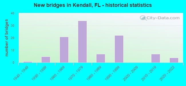
- New bridges - historical statistics
- 11940-1949
- 51950-1959
- 211960-1969
- 341970-1979
- 71980-1989
- 221990-1999
- 72010-2019
- 42020-2022

- Reconstructed bridges - Historical Statistics
- 21970-1979
- 31980-1989
- 21990-1999
- 42000-2009
- 22010-2019
- 12020-2022


- Bridge Condition - Deck
- 3.1%Excellent
- 26.2%Very good
- 61.5%Good
- 3.1%Satisfactory
- 4.6%Fair
- 1.5%Poor

- Bridge Condition - Superstructure
- 3.1%Excellent
- 32.3%Very good
- 55.4%Good
- 1.5%Satisfactory
- 6.2%Fair
- 1.5%Poor

- Bridge Condition - Substructure
- 6.2%Excellent
- 18.5%Very good
- 67.7%Good
- 6.2%Satisfactory
- 1.5%Fair

- Bridge Condition - Channel
- 2.2%Excellent
- 8.9%Very good
- 28.9%Good
- 28.9%Satisfactory
- 31.1%Fair
Find on map >> Show street view
Structure Number: 870953, Location: SR-826 & KENDALL DR (Lat: 25.690656, Lng: -80.316667), Route carried "under" structure: Ramp City street , Year Built: 1998, Structure Length: 0. m, Average Daily Traffic: 3,200 (year 2020), Truck Traffic: 4%, Features Intersected: Dadeland Mall Access, Facility Carried by Structure: KENDALL WB - 826NB
Minimum Vertical Clearance: 5.43m (17.81ft), Kilometerpoint: 0.000, Lanes on structure: 1, Lanes under structure: 2, Material/Design: Prestressed concrete, Design/Construction: Stringer/Multi-beam, Length of Maximum Span: 31.7m (104.0ft)
Find on map >> Show street view
Structure Number: 871033, Location: SR 990 over SR 874 (Lat: 25.672042, Lng: -80.364986), Route carried "under" structure: State highway 874, Year Built: 2011, Structure Length: 0. m, Average Daily Traffic: 172,800 (year 2020), Truck Traffic: 7%, Features Intersected: SR 874, Facility Carried by Structure: WB SR 990 Off Ramp
Minimum Vertical Clearance: 5.09m (16.70ft), Kilometerpoint: 3.660, Lanes on structure: 2, Lanes under structure: 7, Toll: On toll road, Material/Design: Steel continuous, Design/Construction: Stringer/Multi-beam, Length of Maximum Span: 41.8m (137.1ft)