Bridge Statistics for Metairie, Louisiana (LA)
Condition, Traffic, Stress, Structural Evaluation, Project Costs
- National Bridge Inventory (NBI) Statistics
- 134Number of bridges
- 15,751ft / 4,801mTotal length
- $359,111,000Total costs
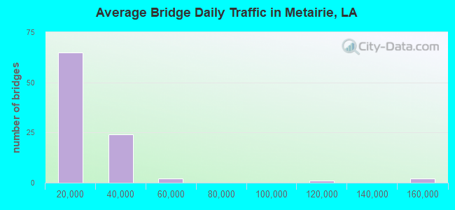
- 1,637,351Total average daily traffic
- 56,634Total average daily truck traffic
- National Bridge Inventory (NBI) Registered Bridges for Metairie
- No street view available for this location

- New bridges - historical statistics
- 81950-1959
- 211960-1969
- 271970-1979
- 131980-1989
- 101990-1999
- 232000-2009
- 82010-2019
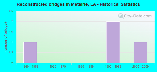
- Reconstructed bridges - Historical Statistics
- 11960-1969
- 01970-1979
- 01980-1989
- 21990-1999
- 12000-2009
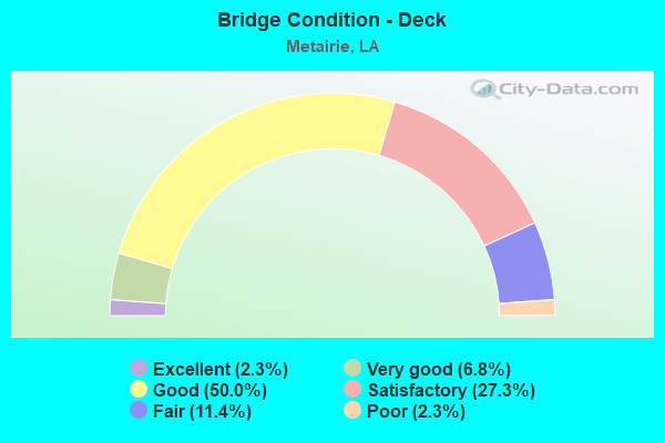
- Bridge Condition - Deck
- 2.3%Excellent
- 6.8%Very good
- 50.0%Good
- 27.3%Satisfactory
- 11.4%Fair
- 2.3%Poor
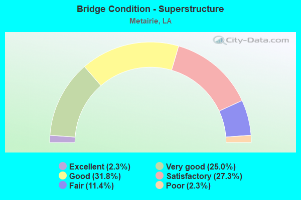
- Bridge Condition - Superstructure
- 2.3%Excellent
- 25.0%Very good
- 31.8%Good
- 27.3%Satisfactory
- 11.4%Fair
- 2.3%Poor
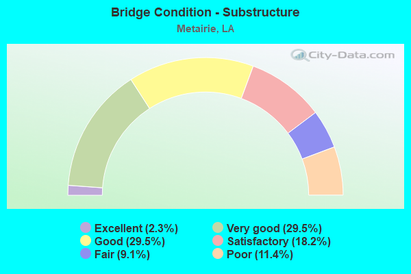
- Bridge Condition - Substructure
- 2.3%Excellent
- 29.5%Very good
- 29.5%Good
- 18.2%Satisfactory
- 9.1%Fair
- 11.4%Poor

- Bridge Condition - Channel
- 1.1%Excellent
- 66.7%Very good
- 29.0%Good
- 3.2%Satisfactory
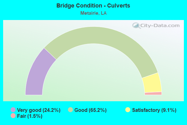
- Bridge Condition - Culverts
- 24.2%Very good
- 65.2%Good
- 9.1%Satisfactory
- 1.5%Fair
Find on map >> Show street view
Structure Number: 22600000000049, Location: 2.06 MI W OF LA 3152 (Lat: 29.985219, Lng: -90.215000), Route carried "on" structure: County highway , Year Built: 2017, Status: Open, Structure Length: 4.88m (16.01ft), Average Daily Traffic: 2,000 (year 2016), Average Future Daily Traffic: 2,200 (year 2036), Design Load: HS 20, Features Intersected: SONIAT CANAL, Facility Carried by Structure: W. METAIRIE AVE N
Minimum Vertical Clearance: 30+ m (98+ ft), Kilometerpoint: 5.723, Lanes on structure: 2, Owner: County Highway Agency, Approaching Roadway Width: 9.8m (32.2ft), Material/Design: Prestressed concrete continuous, Design/Construction: Stringer/Multi-beam, Number Of Spans In Main Unit: 4, Length of Maximum Span: 12.2m (40.0ft), Curb or Sidewalk Widths: Left: 2.1m (6.9ft), Right: 0.0m, Curb-To-Curb Width: 9.8m (32.2ft), Out-to-Out Width: 12.2m (40.0ft)
Condition: Deck: Good, Superstructure: Very good, Substructure: Very good, Channel: Good, Operating Rating: 48.6 metric tons, Method Used To Determine Operating Rating: Load and Resistance Factor Rating (LRFR) rating reported by rating factor(RF) method using HL-93 loadings, Inventory Rating: 37.6 metric tons, Method Used To Determine Inventory Rating: Load and Resistance Factor Rating (LRFR) rating reported by rating factor(RF) method using HL-93 loadings, Structural Evaluation: Equal to present desirable criteria, Deck Geometry: Meets minimum limits, Waterway Adequacy: Equal to present desirable criteria, Approach Roadway Alignment: Equal to present minimum criteria, Designated Inspection Frequency: Every 24 months, Inspection Date: May 2021, Deck Structure Type: Concrete Cast-file-Place
Find on map >> Show street view
Structure Number: 22600000000077, Location: .3 miles east of Clearvie (Lat: 29.993650, Lng: -90.176311), Route carried "on" structure: County highway , Year Built: 2003, Status: Open, Structure Length: 1.25m (4.10ft), Average Daily Traffic: 21,460 (year 2008), Average Future Daily Traffic: 23,600 (year 2028), Features Intersected: Canal 4, Facility Carried by Structure: W Napolean Ave
Minimum Vertical Clearance: 30+ m (98+ ft), Kilometerpoint: 0.000, Lanes on structure: 2, Owner: County Highway Agency, Approaching Roadway Width: 7.6m (24.9ft), Material/Design: Concrete, Design/Construction: Culvert, Number Of Spans In Main Unit: 2, Length of Maximum Span: 6.1m (20.0ft), Curb-To-Curb Width: 7.9m (25.9ft), Out-to-Out Width: 10.7m (35.1ft)
Condition: Channel: Very good, Culverts: Good, Operating Rating: 42.8 metric tons, Method Used To Determine Operating Rating: Load and Resistance Factor Rating (LRFR) rating reported by rating factor(RF) method using HL-93 loadings, Inventory Rating: 33.0 metric tons, Method Used To Determine Inventory Rating: Load and Resistance Factor Rating (LRFR) rating reported by rating factor(RF) method using HL-93 loadings, Structural Evaluation: Better than present minimum criteria, Deck Geometry: High priority of replacement, Waterway Adequacy: Equal to present desirable criteria, Approach Roadway Alignment: Equal to present desirable criteria, Designated Inspection Frequency: Every 24 months, Inspection Date: August 2021
Find on map >> Show street view
Structure Number: 22600000000078, Location: .5 miles east of Williams (Lat: 29.996650, Lng: -90.224969), Route carried "on" structure: County highway , Year Built: 2004, Status: Open, Structure Length: 0.85m (2.79ft), Average Daily Traffic: 2,146 (year 2008), Average Future Daily Traffic: 2,360 (year 2028), Features Intersected: Canal 4, Facility Carried by Structure: W Napolean
Minimum Vertical Clearance: 30+ m (98+ ft), Kilometerpoint: 0.000, Lanes on structure: 2, Owner: County Highway Agency, Approaching Roadway Width: 7.6m (24.9ft), Skew: 30 degrees, Material/Design: Concrete, Design/Construction: Culvert, Number Of Spans In Main Unit: 3, Length of Maximum Span: 2.7m (8.9ft), Curb-To-Curb Width: 8.5m (27.9ft), Out-to-Out Width: 48.8m (160.1ft)
Condition: Channel: Very good, Culverts: Good, Operating Rating: 42.1 metric tons, Method Used To Determine Operating Rating: Load and Resistance Factor Rating (LRFR) rating reported by rating factor(RF) method using HL-93 loadings, Inventory Rating: 32.4 metric tons, Method Used To Determine Inventory Rating: Load and Resistance Factor Rating (LRFR) rating reported by rating factor(RF) method using HL-93 loadings, Structural Evaluation: Better than present minimum criteria, Deck Geometry: High priority of corrective action, Waterway Adequacy: Equal to present desirable criteria, Approach Roadway Alignment: Somewhat better than minimum adequacy, Designated Inspection Frequency: Every 24 months, Inspection Date: March 2021
Find on map >> Show street view
Structure Number: 22600000000079, Location: .6 miles east of Napolean (Lat: 29.996411, Lng: -90.220969), Route carried "on" structure: County highway , Year Built: 2004, Status: Open, Structure Length: 0.85m (2.79ft), Average Daily Traffic: 2,146 (year 2008), Average Future Daily Traffic: 2,360 (year 2028), Features Intersected: Canal 4, Facility Carried by Structure: W Napolean
Minimum Vertical Clearance: 30+ m (98+ ft), Kilometerpoint: 0.000, Lanes on structure: 2, Owner: County Highway Agency, Approaching Roadway Width: 7.6m (24.9ft), Skew: 30 degrees, Material/Design: Concrete, Design/Construction: Culvert, Number Of Spans In Main Unit: 3, Length of Maximum Span: 2.7m (8.9ft), Curb-To-Curb Width: 8.5m (27.9ft), Out-to-Out Width: 48.8m (160.1ft)
Condition: Channel: Very good, Culverts: Very good, Operating Rating: 42.1 metric tons, Method Used To Determine Operating Rating: Load and Resistance Factor Rating (LRFR) rating reported by rating factor(RF) method using HL-93 loadings, Inventory Rating: 32.4 metric tons, Method Used To Determine Inventory Rating: Load and Resistance Factor Rating (LRFR) rating reported by rating factor(RF) method using HL-93 loadings, Structural Evaluation: Equal to present desirable criteria, Deck Geometry: High priority of corrective action, Waterway Adequacy: Superior to present desirable criteria, Approach Roadway Alignment: Meets minimum limits, Designated Inspection Frequency: Every 24 months, Inspection Date: August 2021
Find on map >> Show street view
Structure Number: 22600000000082, Location: 0.3 Miles W of David D (Lat: 29.985339, Lng: -90.217500), Route carried "on" structure: City street , Year Built: 2002, Status: Open, Structure Length: 0.98m (3.22ft), Average Daily Traffic: 387 (year 2008), Average Future Daily Traffic: 426 (year 2028), Features Intersected: Canal #5, Facility Carried by Structure: W Metairie Ave
Minimum Vertical Clearance: 30+ m (98+ ft), Kilometerpoint: 2.425, Lanes on structure: 2, Owner: County Highway Agency, Approaching Roadway Width: 7.3m (24.0ft), Skew: 30 degrees, Material/Design: Concrete, Design/Construction: Culvert, Number Of Spans In Main Unit: 3, Length of Maximum Span: 3.0m (9.8ft), Curb-To-Curb Width: 21.5m (70.5ft), Out-to-Out Width: 77.9m (255.6ft)
Condition: Channel: Very good, Culverts: Very good, Operating Rating: 31.4 metric tons, Method Used To Determine Operating Rating: Load and Resistance Factor Rating (LRFR) rating reported by rating factor(RF) method using HL-93 loadings, Inventory Rating: 24.3 metric tons, Method Used To Determine Inventory Rating: Load and Resistance Factor Rating (LRFR) rating reported by rating factor(RF) method using HL-93 loadings, Structural Evaluation: Equal to present minimum criteria, Deck Geometry: Superior to present desirable criteria, Waterway Adequacy: Superior to present desirable criteria, Approach Roadway Alignment: Somewhat better than minimum adequacy, Designated Inspection Frequency: Every 24 months, Inspection Date: August 2021, Deck Structure Type: Concrete Cast-file-Place
Find on map >> Show street view
Structure Number: 22600000000083, Location: 500' West of David Dr (Lat: 29.996119, Lng: -90.219011), Route carried "on" structure: City street , Year Built: 2005, Status: Open, Structure Length: 3.75m (12.30ft), Average Daily Traffic: 21,463 (year 2008), Average Future Daily Traffic: 23,609 (year 2028), Features Intersected: Soniat Canal, Facility Carried by Structure: West Napoleon Ave
Minimum Vertical Clearance: 30+ m (98+ ft), Kilometerpoint: 2.694, Lanes on structure: 2, Owner: County Highway Agency, Approaching Roadway Width: 7.3m (24.0ft), Skew: 1 degrees, Material/Design: Concrete continuous, Design/Construction: Slab, Number Of Spans In Main Unit: 3, Length of Maximum Span: 12.5m (41.0ft), Curb or Sidewalk Widths: Left: 0.0m, Right: 1.9m (6.2ft), Curb-To-Curb Width: 9.8m (32.2ft), Out-to-Out Width: 12.8m (42.0ft)
Condition: Deck: Good, Superstructure: Good, Substructure: Very good, Channel: Very good, Operating Rating: 40.5 metric tons, Method Used To Determine Operating Rating: Load and Resistance Factor Rating (LRFR) rating reported by rating factor(RF) method using HL-93 loadings, Inventory Rating: 31.1 metric tons, Method Used To Determine Inventory Rating: Load and Resistance Factor Rating (LRFR) rating reported by rating factor(RF) method using HL-93 loadings, Structural Evaluation: Better than present minimum criteria, Deck Geometry: Meets minimum limits, Waterway Adequacy: Equal to present desirable criteria, Approach Roadway Alignment: Equal to present desirable criteria, Designated Inspection Frequency: Every 24 months, Inspection Date: August 2021, Deck Structure Type: Concrete Cast-file-Place
Find on map >> Show street view
Structure Number: 22600000000084, Location: 500' W of David Dr (Lat: 29.996461, Lng: -90.218761), Route carried "on" structure: City street , Year Built: 2005, Status: Open, Structure Length: 3.75m (12.30ft), Average Daily Traffic: 24,341 (year 2008), Average Future Daily Traffic: 26,775 (year 2028), Design Load: HS 20, Features Intersected: Soniat Canal, Facility Carried by Structure: West Napoleon Ave
Minimum Vertical Clearance: 30+ m (98+ ft), Kilometerpoint: 6.751, Lanes on structure: 2, Owner: County Highway Agency, Approaching Roadway Width: 7.3m (24.0ft), Skew: 1 degrees, Material/Design: Concrete continuous, Design/Construction: Slab, Number Of Spans In Main Unit: 3, Length of Maximum Span: 12.5m (41.0ft), Curb or Sidewalk Widths: Left: 1.9m (6.2ft), Right: 0.0m, Curb-To-Curb Width: 9.8m (32.2ft), Out-to-Out Width: 12.8m (42.0ft)
Condition: Deck: Good, Superstructure: Good, Substructure: Very good, Channel: Very good, Operating Rating: 40.5 metric tons, Method Used To Determine Operating Rating: Load and Resistance Factor Rating (LRFR) rating reported by rating factor(RF) method using HL-93 loadings, Inventory Rating: 31.1 metric tons, Method Used To Determine Inventory Rating: Load and Resistance Factor Rating (LRFR) rating reported by rating factor(RF) method using HL-93 loadings, Structural Evaluation: Better than present minimum criteria, Deck Geometry: Meets minimum limits, Waterway Adequacy: Equal to present desirable criteria, Approach Roadway Alignment: Equal to present desirable criteria, Designated Inspection Frequency: Every 24 months, Inspection Date: August 2021, Deck Structure Type: Concrete Cast-file-Place
Find on map >> Show street view
Structure Number: 22600000000085, Location: 0.3 Mi E of Clearview Pkw (Lat: 29.993300, Lng: -90.173569), Route carried "on" structure: City street , Year Built: 2003, Status: Open, Structure Length: 0.79m (2.59ft), Average Daily Traffic: 532 (year 2016), Average Future Daily Traffic: 585 (year 2036), Features Intersected: Canal #4, Facility Carried by Structure: West Napoleon Ave
Minimum Vertical Clearance: 30+ m (98+ ft), Kilometerpoint: 6.553, Lanes on structure: 2, Owner: County Highway Agency, Approaching Roadway Width: 7.3m (24.0ft), Skew: 30 degrees, Material/Design: Concrete, Design/Construction: Culvert, Number Of Spans In Main Unit: 3, Length of Maximum Span: 2.4m (7.9ft), Curb-To-Curb Width: 19.8m (65.0ft), Out-to-Out Width: 66.4m (217.8ft)
Condition: Channel: Very good, Culverts: Very good, Operating Rating: 42.1 metric tons, Method Used To Determine Operating Rating: Load and Resistance Factor Rating (LRFR) rating reported by rating factor(RF) method using HL-93 loadings, Inventory Rating: 32.4 metric tons, Method Used To Determine Inventory Rating: Load and Resistance Factor Rating (LRFR) rating reported by rating factor(RF) method using HL-93 loadings, Structural Evaluation: Equal to present desirable criteria, Deck Geometry: Superior to present desirable criteria, Waterway Adequacy: Superior to present desirable criteria, Approach Roadway Alignment: Meets minimum limits, Designated Inspection Frequency: Every 24 months, Inspection Date: August 2021, Deck Structure Type: Concrete Cast-file-Place
Find on map >> Show street view
Structure Number: 22600000020029, Location: 0.6 MILE EAST OF POWER BL (Lat: 30.018061, Lng: -90.213681), Route carried "on" structure: County highway , Year Built: 2011, Status: Posted for load, Structure Length: 5.36m (17.59ft), Design Load: HS 20, Features Intersected: ELMWOOD CANAL, Facility Carried by Structure: W Esplanade Ave S
Minimum Vertical Clearance: 30+ m (98+ ft), Kilometerpoint: 0.000, Lanes on structure: 4, Owner: County Highway Agency, Approaching Roadway Width: 9.8m (32.2ft), Skew: 36 degrees, Material/Design: Concrete, Design/Construction: Slab, Number Of Spans In Main Unit: 4, Length of Maximum Span: 13.7m (44.9ft), Curb or Sidewalk Widths: Left: 2.4m (7.9ft), Right: 3.0m (9.8ft), Curb-To-Curb Width: 20.1m (65.9ft), Out-to-Out Width: 28.7m (94.2ft)
Condition: Deck: Good, Superstructure: Good, Substructure: Very good, Channel: Very good, Operating Rating: 13.3 metric tons, Method Used To Determine Operating Rating: Load and Resistance Factor Rating (LRFR) rating reported by rating factor(RF) method using HL-93 loadings, Inventory Rating: 10.4 metric tons, Method Used To Determine Inventory Rating: Load and Resistance Factor Rating (LRFR) rating reported by rating factor(RF) method using HL-93 loadings, Structural Evaluation: High priority of corrective action, Deck Geometry: Better than present minimum criteria, Waterway Adequacy: Equal to present desirable criteria, Approach Roadway Alignment: Equal to present minimum criteria, Bridge Posting: Required (Relationship of Operating Rating to Maximum Legal Load: 30.0 - 39.9% below), Designated Inspection Frequency: Every 24 months, Other Special Inspection Frequency: Every 12 months, Inspection Date: May 2021, Other Special Inspection Date: May 2020, Deck Structure Type: Concrete Precast Panels, Wearing Surface/Protective System: Wearing Surface: Bituminous
Find on map >> Show street view
Structure Number: 22600000020407, Location: 2 MILES WEST OF ORLEANS P (Lat: 29.997339, Lng: -90.145000), Route carried "on" structure: Ramp Interstate 10, Year Built: 2009, Status: Open, Structure Length: 47.03m (154.30ft), Average Daily Traffic: 15,340 (year 2016), Truck Traffic: 25%, Average Future Daily Traffic: 25,721 (year 2036), Design Load: HS 20, Features Intersected: I-10 WB OFF RAMP
Minimum Vertical Clearance: 30+ m (98+ ft), Kilometerpoint: 0.151, Lanes on structure: 1, Lanes under structure: 2, Owner: State Highway Agency, Approaching Roadway Width: 7.6m (24.9ft), Skew: 30 degrees, Material/Design: Steel, Design/Construction: Girder and Floorbeam System, Number Of Spans In Main Unit: 2, Number Of Approach Spans: 30, Length of Maximum Span: 65.2m (213.9ft), Curb-To-Curb Width: 7.6m (24.9ft), Out-to-Out Width: 8.5m (27.9ft)
Condition: Deck: Good, Superstructure: Very good, Substructure: Good, Operating Rating: 35.6 metric tons, Method Used To Determine Operating Rating: Load and Resistance Factor Rating (LRFR) rating reported by rating factor(RF) method using HL-93 loadings, Inventory Rating: 27.5 metric tons, Method Used To Determine Inventory Rating: Load and Resistance Factor Rating (LRFR) rating reported by rating factor(RF) method using HL-93 loadings, Structural Evaluation: Equal to present minimum criteria, Deck Geometry: Better than present minimum criteria, Underclear: High priority of corrective action, Approach Roadway Alignment: Better than present minimum criteria, Designated Inspection Frequency: Every 24 months, Critical Feature Inspection Frequency: Every 24 months, Inspection Date: July 2021, Critical Feature Inspection Date: July 2021, Deck Structure Type: Concrete Cast-file-Place, Wearing Surface/Protective System: Wearing Surface: Monolithic Concrete
Find on map >> Show street view
Structure Number: 22600000020454, Location: 0.3 MILES NORTH OF I 10 (Lat: 29.999050, Lng: -90.153800), Route carried "on" structure: Ramp Interstate 10, Year Built: 2011, Status: Open, Structure Length: 88.18m (289.30ft), Average Daily Traffic: 10,010 (year 2016), Truck Traffic: 25%, Average Future Daily Traffic: 17,017 (year 2036), Design Load: HS 20, Features Intersected: VETERANS BLVD OFF RAMP
Minimum Vertical Clearance: 30+ m (98+ ft), Kilometerpoint: 0.227, Lanes on structure: 1, Lanes under structure: 1, Owner: State Highway Agency, Approaching Roadway Width: 9.1m (29.9ft), Skew: 30 degrees, Material/Design: Steel, Design/Construction: Girder and Floorbeam System, Number Of Spans In Main Unit: 34, Number Of Approach Spans: 12, Length of Maximum Span: 40.2m (131.9ft), Curb-To-Curb Width: 9.1m (29.9ft), Out-to-Out Width: 9.8m (32.2ft)
Condition: Deck: Very good, Superstructure: Good, Substructure: Very good, Channel: Very good, Operating Rating: 34.0 metric tons, Method Used To Determine Operating Rating: Load and Resistance Factor Rating (LRFR) rating reported by rating factor(RF) method using HL-93 loadings, Inventory Rating: 26.2 metric tons, Method Used To Determine Inventory Rating: Load and Resistance Factor Rating (LRFR) rating reported by rating factor(RF) method using HL-93 loadings, Structural Evaluation: Equal to present minimum criteria, Deck Geometry: Superior to present desirable criteria, Underclear: Superior to present desirable criteria, Approach Roadway Alignment: Better than present minimum criteria, Designated Inspection Frequency: Every 24 months, Inspection Date: December 2021, Deck Structure Type: Concrete Cast-file-Place, Wearing Surface/Protective System: Wearing Surface: Monolithic Concrete
Find on map >> Show street view
Structure Number: 22600000020458, Location: 1.5 MILES EAST OF CLEARVI (Lat: 29.995639, Lng: -90.154100), Route carried "on" structure: Ramp Interstate 10, Year Built: 2010, Status: Open, Structure Length: 44.32m (145.41ft), Average Daily Traffic: 10,010 (year 2016), Truck Traffic: 25%, Average Future Daily Traffic: 17,017 (year 2036), Design Load: HS 20, Features Intersected: I-10 WEST AND EAST
Minimum Vertical Clearance: 5.51m (18.08ft), Kilometerpoint: 0.299, Lanes on structure: 1, Lanes under structure: 11, Owner: State Highway Agency, Approaching Roadway Width: 8.5m (27.9ft), Skew: 34 degrees, Material/Design: Steel, Design/Construction: Stringer/Multi-beam, Number Of Spans In Main Unit: 2, Number Of Approach Spans: 31, Length of Maximum Span: 61.0m (200.1ft), Curb-To-Curb Width: 7.0m (23.0ft), Out-to-Out Width: 9.1m (29.9ft)
Condition: Deck: Good, Superstructure: Very good, Substructure: Very good, Operating Rating: 43.7 metric tons, Method Used To Determine Operating Rating: Load and Resistance Factor Rating (LRFR) rating reported by rating factor(RF) method using HL-93 loadings, Inventory Rating: 33.7 metric tons, Method Used To Determine Inventory Rating: Load and Resistance Factor Rating (LRFR) rating reported by rating factor(RF) method using HL-93 loadings, Structural Evaluation: Equal to present desirable criteria, Deck Geometry: Equal to present minimum criteria, Underclear: Superior to present desirable criteria, Approach Roadway Alignment: Somewhat better than minimum adequacy, Designated Inspection Frequency: Every 24 months, Inspection Date: April 2020, Deck Structure Type: Concrete Cast-file-Place, Wearing Surface/Protective System: Wearing Surface: Monolithic Concrete
Find on map >> Show street view
Structure Number: 22600000020471, Location: 0.5 MILES NORTH OF I-10 (Lat: 30.000181, Lng: -90.155700), Route carried "on" structure: Ramp Interstate 10, Year Built: 2012, Status: Open, Structure Length: 26.97m (88.48ft), Average Daily Traffic: 10,010 (year 2016), Truck Traffic: 25%, Average Future Daily Traffic: 17,017 (year 2036), Design Load: HS 20, Features Intersected: GROUND
Minimum Vertical Clearance: 30+ m (98+ ft), Kilometerpoint: 0.111, Lanes on structure: 1, Owner: State Highway Agency, Approaching Roadway Width: 7.3m (24.0ft), Skew: 30 degrees, Material/Design: Prestressed concrete, Design/Construction: Stringer/Multi-beam, Number Of Spans In Main Unit: 9, Number Of Approach Spans: 7, Length of Maximum Span: 14.0m (45.9ft), Curb-To-Curb Width: 7.3m (24.0ft), Out-to-Out Width: 8.5m (27.9ft)
Condition: Deck: Good, Superstructure: Very good, Substructure: Good, Operating Rating: 35.3 metric tons, Method Used To Determine Operating Rating: Load and Resistance Factor Rating (LRFR) rating reported by rating factor(RF) method using HL-93 loadings, Inventory Rating: 27.2 metric tons, Method Used To Determine Inventory Rating: Load and Resistance Factor Rating (LRFR) rating reported by rating factor(RF) method using HL-93 loadings, Structural Evaluation: Equal to present minimum criteria, Deck Geometry: Better than present minimum criteria, Approach Roadway Alignment: Equal to present minimum criteria, Designated Inspection Frequency: Every 24 months, Inspection Date: July 2020, Deck Structure Type: Concrete Cast-file-Place, Wearing Surface/Protective System: Wearing Surface: Monolithic Concrete
Find on map >> Show street view
Structure Number: 22600000020472, Location: 1 MILE NORTH OF I-10 (Lat: 30.004019, Lng: -90.155400), Route carried "on" structure: Ramp Interstate 10, Year Built: 2012, Status: Open, Structure Length: 111.68m (366.40ft), Average Daily Traffic: 10,010 (year 2016), Truck Traffic: 25%, Average Future Daily Traffic: 25,721 (year 2036), Design Load: HS 20, Features Intersected: I-10
Minimum Vertical Clearance: 30+ m (98+ ft), Kilometerpoint: 0.164, Lanes on structure: 1, Lanes under structure: 20, Owner: State Highway Agency, Approaching Roadway Width: 7.3m (24.0ft), Skew: 30 degrees, Material/Design: Steel, Design/Construction: Stringer/Multi-beam, Number Of Spans In Main Unit: 10, Number Of Approach Spans: 23, Length of Maximum Span: 76.2m (250.0ft), Curb-To-Curb Width: 7.3m (24.0ft), Out-to-Out Width: 8.2m (26.9ft)
Condition: Deck: Good, Superstructure: Very good, Substructure: Very good, Operating Rating: 36.9 metric tons, Method Used To Determine Operating Rating: Load and Resistance Factor Rating (LRFR) rating reported by rating factor(RF) method using HL-93 loadings, Inventory Rating: 27.9 metric tons, Method Used To Determine Inventory Rating: Load and Resistance Factor Rating (LRFR) rating reported by rating factor(RF) method using HL-93 loadings, Structural Evaluation: Better than present minimum criteria, Deck Geometry: Better than present minimum criteria, Underclear: Better than present minimum criteria, Approach Roadway Alignment: Equal to present desirable criteria, Designated Inspection Frequency: Every 24 months, Inspection Date: July 2020, Deck Structure Type: Concrete Cast-file-Place, Wearing Surface/Protective System: Wearing Surface: Monolithic Concrete
Find on map >> Show street view
Structure Number: 22600000020521, Location: 0.5 MI EAST OF CLEARVIEW (Lat: 29.999069, Lng: -90.156800), Route carried "on" structure: Ramp Interstate 10, Year Built: 2009, Status: Open, Structure Length: 38.07m (124.90ft), Average Daily Traffic: 10,010 (year 2016), Truck Traffic: 25%, Average Future Daily Traffic: 17,017 (year 2036), Design Load: HS 20, Features Intersected: I-10 EAST AND WEST BOUND
Minimum Vertical Clearance: 30+ m (98+ ft), Kilometerpoint: 0.225, Lanes on structure: 1, Lanes under structure: 11, Owner: State Highway Agency, Approaching Roadway Width: 10.4m (34.1ft), Skew: 30 degrees, Material/Design: Steel, Design/Construction: Girder and Floorbeam System, Number Of Spans In Main Unit: 1, Number Of Approach Spans: 27, Length of Maximum Span: 117.3m (384.8ft), Curb-To-Curb Width: 9.4m (30.8ft), Out-to-Out Width: 10.4m (34.1ft)
Condition: Deck: Good, Superstructure: Good, Substructure: Good, Operating Rating: 23.3 metric tons, Method Used To Determine Operating Rating: Load and Resistance Factor Rating (LRFR) rating reported by rating factor(RF) method using HL-93 loadings, Inventory Rating: 17.8 metric tons, Method Used To Determine Inventory Rating: Load and Resistance Factor Rating (LRFR) rating reported by rating factor(RF) method using HL-93 loadings, Structural Evaluation: Meets minimum limits, Deck Geometry: Superior to present desirable criteria, Underclear: Superior to present desirable criteria, Approach Roadway Alignment: Somewhat better than minimum adequacy, Designated Inspection Frequency: Every 24 months, Inspection Date: May 2020, Deck Structure Type: Other, Wearing Surface/Protective System: Wearing Surface: Monolithic Concrete
Find on map >> Show street view
Structure Number: 22600000020525, Location: 0.5 MI E OF CAUSEWAY BLVD (Lat: 30.015969, Lng: -90.145039), Route carried "on" structure: County highway , Year Built: 2015, Status: Open, Structure Length: 3.05m (10.01ft), Design Load: HS 20, Features Intersected: BONNABEL CANAL, Facility Carried by Structure: Poplar St
Minimum Vertical Clearance: 30+ m (98+ ft), Kilometerpoint: 0.000, Lanes on structure: 2, Owner: County Highway Agency, Approaching Roadway Width: 10.4m (34.1ft), Skew: 30 degrees, Material/Design: Concrete, Design/Construction: Slab, Number Of Spans In Main Unit: 5, Length of Maximum Span: 6.1m (20.0ft), Curb-To-Curb Width: 8.5m (27.9ft), Out-to-Out Width: 10.8m (35.4ft)
Condition: Deck: Excellent, Superstructure: Excellent, Substructure: Excellent, Channel: Very good, Operating Rating: 59.9 metric tons, Method Used To Determine Operating Rating: Load and Resistance Factor Rating (LRFR) rating reported by rating factor(RF) method using HL-93 loadings, Inventory Rating: 46.3 metric tons, Method Used To Determine Inventory Rating: Load and Resistance Factor Rating (LRFR) rating reported by rating factor(RF) method using HL-93 loadings, Structural Evaluation: Superior to present desirable criteria, Deck Geometry: Better than present minimum criteria, Waterway Adequacy: Equal to present desirable criteria, Approach Roadway Alignment: Equal to present desirable criteria, Designated Inspection Frequency: Every 24 months, Inspection Date: May 2021, Deck Structure Type: Concrete Cast-file-Place, Wearing Surface/Protective System: Wearing Surface: Monolithic Concrete
Find on map >> Show street view
Structure Number: 2260000010003, Location: .5 MILES NORTH OF US61 (Lat: 29.984481, Lng: -90.207081), Route carried "on" structure: County highway , Year Built: 2009, Status: Open, Structure Length: 0.88m (2.89ft), Design Load: HS 20, Features Intersected: CANAL NUMBER 5, Facility Carried by Structure: AIRLINE PARK BLVD
Minimum Vertical Clearance: 30+ m (98+ ft), Kilometerpoint: 0.000, Lanes on structure: 4, Owner: County Highway Agency, Approaching Roadway Width: 6.1m (20.0ft), Skew: 32 degrees, Material/Design: Concrete, Design/Construction: Culvert, Number Of Spans In Main Unit: 3, Length of Maximum Span: 2.7m (8.9ft), Curb or Sidewalk Widths: Left: 2.4m (7.9ft), Right: 2.4m (7.9ft), Curb-To-Curb Width: 16.5m (54.1ft), Out-to-Out Width: 77.9m (255.6ft)
Condition: Channel: Very good, Culverts: Good, Operating Rating: 42.1 metric tons, Method Used To Determine Operating Rating: Load and Resistance Factor Rating (LRFR) rating reported by rating factor(RF) method using HL-93 loadings, Inventory Rating: 32.4 metric tons, Method Used To Determine Inventory Rating: Load and Resistance Factor Rating (LRFR) rating reported by rating factor(RF) method using HL-93 loadings, Structural Evaluation: Better than present minimum criteria, Deck Geometry: Meets minimum limits, Waterway Adequacy: Better than present minimum criteria, Approach Roadway Alignment: Equal to present desirable criteria, Designated Inspection Frequency: Every 24 months, Inspection Date: March 2021, Deck Structure Type: Concrete Cast-file-Place
Find on map >> Show street view
Structure Number: 22600000100049, Location: .04 MILES WEST OF ACADEMY (Lat: 30.011839, Lng: -90.211489), Route carried "on" structure: County highway , Year Built: 2008, Status: Open, Structure Length: 5.00m (16.40ft), Design Load: HS 20, Features Intersected: ELMWOOD CANAL, Facility Carried by Structure: KAWANEE AVE
Minimum Vertical Clearance: 30+ m (98+ ft), Kilometerpoint: 0.000, Lanes on structure: 2, Owner: County Highway Agency, Approaching Roadway Width: 9.4m (30.8ft), Skew: 32 degrees, Material/Design: Concrete, Design/Construction: Channel Beam, Number Of Spans In Main Unit: 4, Length of Maximum Span: 12.5m (41.0ft), Curb or Sidewalk Widths: Left: 1.2m (3.9ft), Right: 1.2m (3.9ft), Curb-To-Curb Width: 9.8m (32.2ft), Out-to-Out Width: 13.0m (42.7ft)
Condition: Deck: Satisfactory, Superstructure: Satisfactory, Substructure: Very good, Channel: Very good, Operating Rating: 36.0 metric tons, Method Used To Determine Operating Rating: Load and Resistance Factor Rating (LRFR) rating reported by rating factor(RF) method using HL-93 loadings, Inventory Rating: 27.5 metric tons, Method Used To Determine Inventory Rating: Load and Resistance Factor Rating (LRFR) rating reported by rating factor(RF) method using HL-93 loadings, Structural Evaluation: Equal to present minimum criteria, Deck Geometry: Equal to present desirable criteria, Waterway Adequacy: Better than present minimum criteria, Approach Roadway Alignment: Superior to present desirable criteria, Designated Inspection Frequency: Every 24 months, Underwater Inspection Frequency: Every 60 months, Inspection Date: March 2021, Underwater Inspection Date: December 2018, Deck Structure Type: Concrete Cast-file-Place, Wearing Surface/Protective System: Wearing Surface: Monolithic Concrete
Find on map >> Show street view
Structure Number: 22600000100107, Location: 0.7 MI. E. OF TRANSCONTIN (Lat: 30.016331, Lng: -90.187889), Route carried "on" structure: County highway , Year Built: 2012, Status: Open, Structure Length: 0.91m (2.99ft), Average Daily Traffic: 20,464 (year 2012), Average Future Daily Traffic: 34,788 (year 2036), Design Load: HS 20, Features Intersected: CANAL NO 2, Facility Carried by Structure: Clearview PKWY
Minimum Vertical Clearance: 30+ m (98+ ft), Kilometerpoint: 0.000, Lanes on structure: 6, Owner: County Highway Agency, Approaching Roadway Width: 15.9m (52.2ft), Skew: 30 degrees, Material/Design: Concrete, Design/Construction: Culvert, Number Of Spans In Main Unit: 3, Length of Maximum Span: 3.0m (9.8ft), Curb or Sidewalk Widths: Left: 1.2m (3.9ft), Right: 1.2m (3.9ft), Curb-To-Curb Width: 24.7m (81.0ft), Out-to-Out Width: 82.9m (272.0ft)
Condition: Channel: Excellent, Culverts: Good, Operating Rating: 42.1 metric tons, Method Used To Determine Operating Rating: Load and Resistance Factor Rating (LRFR) rating reported by rating factor(RF) method using HL-93 loadings, Inventory Rating: 32.4 metric tons, Method Used To Determine Inventory Rating: Load and Resistance Factor Rating (LRFR) rating reported by rating factor(RF) method using HL-93 loadings, Structural Evaluation: Better than present minimum criteria, Deck Geometry: Somewhat better than minimum adequacy, Approach Roadway Alignment: Equal to present desirable criteria, Designated Inspection Frequency: Every 24 months, Inspection Date: April 2021, Deck Structure Type: Other
Find on map >> Show street view
Structure Number: 2260000010012, Location: .8 MILES NORTH OF WEST ME (Lat: 29.996169, Lng: -90.217611), Route carried "on" structure: County highway , Year Built: 2004, Status: Open, Structure Length: 0.64m (2.10ft), Design Load: HS 20, Features Intersected: CANAL NO. 4, Facility Carried by Structure: David Dr
Minimum Vertical Clearance: 30+ m (98+ ft), Kilometerpoint: 0.000, Lanes on structure: 8, Owner: County Highway Agency, Approaching Roadway Width: 11.6m (38.1ft), Skew: 30 degrees, Material/Design: Concrete, Design/Construction: Culvert, Number Of Spans In Main Unit: 2, Length of Maximum Span: 3.0m (9.8ft), Curb or Sidewalk Widths: Left: 1.2m (3.9ft), Right: 1.2m (3.9ft), Curb-To-Curb Width: 23.2m (76.1ft), Out-to-Out Width: 24.1m (79.1ft)
Condition: Channel: Very good, Culverts: Very good, Operating Rating: 28.8 metric tons, Method Used To Determine Operating Rating: Load and Resistance Factor Rating (LRFR) rating reported by rating factor(RF) method using HL-93 loadings, Inventory Rating: 22.0 metric tons, Method Used To Determine Inventory Rating: Load and Resistance Factor Rating (LRFR) rating reported by rating factor(RF) method using HL-93 loadings, Structural Evaluation: Equal to present minimum criteria, Deck Geometry: High priority of replacement, Waterway Adequacy: Equal to present desirable criteria, Approach Roadway Alignment: Equal to present desirable criteria, Designated Inspection Frequency: Every 24 months, Inspection Date: April 2021, Deck Structure Type: Concrete Cast-file-Place
Find on map >> Show street view
Structure Number: 22600000100124, Location: CLEARVIEW PARKWAY @ VETER (Lat: 30.005169, Lng: -90.185589), Route carried "on" structure: County highway , Year Built: 1983, Year Reconstructed: 2003, Status: Open, Structure Length: 0.88m (2.89ft), Design Load: HS 20, Features Intersected: CANAL #3, Facility Carried by Structure: CLEARVIEW PKWY
Minimum Vertical Clearance: 30+ m (98+ ft), Kilometerpoint: 0.000, Lanes on structure: 15, Owner: County Highway Agency, Approaching Roadway Width: 6.7m (22.0ft), Skew: 30 degrees, Material/Design: Concrete, Design/Construction: Culvert, Number Of Spans In Main Unit: 3, Length of Maximum Span: 3.0m (9.8ft), Curb or Sidewalk Widths: Left: 1.5m (4.9ft), Right: 1.5m (4.9ft), Curb-To-Curb Width: 23.4m (76.8ft), Out-to-Out Width: 303.0m (994.1ft)
Condition: Channel: Very good, Culverts: Good, Operating Rating: 42.1 metric tons, Method Used To Determine Operating Rating: Load and Resistance Factor Rating (LRFR) rating reported by rating factor(RF) method using HL-93 loadings, Inventory Rating: 32.4 metric tons, Method Used To Determine Inventory Rating: Load and Resistance Factor Rating (LRFR) rating reported by rating factor(RF) method using HL-93 loadings, Structural Evaluation: Better than present minimum criteria, Deck Geometry: High priority of replacement, Waterway Adequacy: Better than present minimum criteria, Approach Roadway Alignment: Equal to present desirable criteria, Length Of Structure Improvement: 1.49m (4.89ft), Designated Inspection Frequency: Every 24 months, Inspection Date: March 2021, Bridge Improvement Cost: $244,000, Total Project Cost: $366,000 ( Estimate for 2016), Deck Structure Type: Concrete Cast-file-Place
Find on map >> Show street view
Structure Number: 22604300100141, Location: .14 MI SOUTH OF US 61 (Lat: 29.968439, Lng: -90.203761), Route carried "on" structure: State highway 3139, Year Built: 1977, Status: Open, Structure Length: 41.54m (136.29ft), Average Daily Traffic: 16,607 (year 2016), Truck Traffic: 18%, Average Future Daily Traffic: 33,456 (year 2036), Design Load: HS 20, Features Intersected: I.C.G. RR
Minimum Vertical Clearance: 30+ m (98+ ft), Kilometerpoint: 0.211, Lanes on structure: 2, Base Highway Network: Yes (Inventory Route: 430-01-1, Subroute: 10), Owner: State Highway Agency, Approaching Roadway Width: 10.7m (35.1ft), Skew: 10 degrees, Material/Design: Prestressed concrete, Design/Construction: Stringer/Multi-beam, Number Of Spans In Main Unit: 15, Number Of Approach Spans: 11, Length of Maximum Span: 24.4m (80.1ft), Curb-To-Curb Width: 9.1m (29.9ft), Out-to-Out Width: 10.2m (33.5ft)
Condition: Deck: Good, Superstructure: Good, Substructure: Good, Operating Rating: 86.2 metric tons, Method Used To Determine Operating Rating: Load Factor (LF), Inventory Rating: 34.5 metric tons, Method Used To Determine Inventory Rating: Load Factor (LF), Structural Evaluation: Better than present minimum criteria, Deck Geometry: Meets minimum limits, Underclear: Superior to present desirable criteria, Waterway Adequacy: Equal to present desirable criteria, Approach Roadway Alignment: Better than present minimum criteria, Designated Inspection Frequency: Every 24 months, Inspection Date: May 2020, Deck Structure Type: Concrete Cast-file-Place
Find on map >> Show street view
Structure Number: 22604300101801, Location: 1.1 MI EAST OF LA 3154 (Lat: 29.969689, Lng: -90.176200), Route carried "on" structure: State highway 3139, Year Built: 1986, Status: Open, Structure Length: 65.44m (214.70ft), Average Daily Traffic: 33,214 (year 2016), Truck Traffic: 18%, Average Future Daily Traffic: 55,760 (year 2036), Design Load: HS 20, Features Intersected: CENTRAL AVE,IC,KCS,SP.RR
Minimum Vertical Clearance: 7.62m (25.00ft), Kilometerpoint: 2.945, Lanes on structure: 3, Lanes under structure: 3, Base Highway Network: Yes (Inventory Route: 430-01-1, Subroute: 10), Owner: State Highway Agency, Approaching Roadway Width: 28.3m (92.8ft), Skew: 30 degrees, Material/Design: Prestressed concrete, Design/Construction: Stringer/Multi-beam, Number Of Spans In Main Unit: 25, Number Of Approach Spans: 8, Length of Maximum Span: 29.0m (95.1ft), Curb-To-Curb Width: 27.9m (91.5ft), Out-to-Out Width: 28.7m (94.2ft)
Condition: Deck: Satisfactory, Superstructure: Good, Substructure: Good, Operating Rating: 68.9 metric tons, Method Used To Determine Operating Rating: Load Factor (LF), Inventory Rating: 41.7 metric tons, Method Used To Determine Inventory Rating: Load Factor (LF), Structural Evaluation: Better than present minimum criteria, Deck Geometry: Superior to present desirable criteria, Underclear: Equal to present minimum criteria, Approach Roadway Alignment: Equal to present desirable criteria, Designated Inspection Frequency: Every 24 months, Inspection Date: May 2020, Deck Structure Type: Concrete Cast-file-Place, Wearing Surface/Protective System: Wearing Surface: Monolithic Concrete
Find on map >> Show street view
Structure Number: 22629502900511, Location: ONE MILE FROM LA 3134 ON (Lat: 29.836250, Lng: -90.084119), Route carried "on" structure: County highway , Year Built: 2005, Status: Open, Structure Length: 6.10m (20.01ft), Design Load: HS 20, Features Intersected: DESTREHAN AVE @ PIPE CAN, Facility Carried by Structure: Destrehan Ave
Minimum Vertical Clearance: 30+ m (98+ ft), Kilometerpoint: 0.000, Lanes on structure: 2, Owner: County Highway Agency, Approaching Roadway Width: 13.4m (44.0ft), Material/Design: Concrete, Design/Construction: Channel Beam, Number Of Spans In Main Unit: 5, Length of Maximum Span: 12.2m (40.0ft), Curb-To-Curb Width: 12.9m (42.3ft), Out-to-Out Width: 13.7m (44.9ft)
Condition: Deck: Very good, Superstructure: Very good, Substructure: Very good, Channel: Very good, Operating Rating: 34.7 metric tons, Method Used To Determine Operating Rating: Load and Resistance Factor Rating (LRFR) rating reported by rating factor(RF) method using HL-93 loadings, Inventory Rating: 26.9 metric tons, Method Used To Determine Inventory Rating: Load and Resistance Factor Rating (LRFR) rating reported by rating factor(RF) method using HL-93 loadings, Structural Evaluation: Equal to present minimum criteria, Deck Geometry: Superior to present desirable criteria, Waterway Adequacy: Equal to present desirable criteria, Approach Roadway Alignment: Equal to present desirable criteria, Designated Inspection Frequency: Every 24 months, Inspection Date: January 2021, Deck Structure Type: Concrete Precast Panels, Wearing Surface/Protective System: Wearing Surface: Monolithic Concrete
Find on map >> Show street view
Structure Number: 22629585900761, Location: 0.01M NORTH OF ORPHEUM (Lat: 29.975989, Lng: -90.125611), Route carried "on" structure: City street , Year Built: 1993, Status: Open, Structure Length: 3.32m (10.89ft), Average Daily Traffic: 2,000 (year 1991), Average Future Daily Traffic: 3,400 (year 2036), Design Load: HS 20, Features Intersected: METAIRIE RELIEF CANAL, Facility Carried by Structure: PALM ST
Minimum Vertical Clearance: 30+ m (98+ ft), Kilometerpoint: 0.000, Lanes on structure: 2, Owner: County Highway Agency, Approaching Roadway Width: 7.3m (24.0ft), Skew: 3 degrees, Material/Design: Prestressed concrete, Design/Construction: Stringer/Multi-beam, Number Of Spans In Main Unit: 1, Length of Maximum Span: 33.2m (108.9ft), Curb or Sidewalk Widths: Left: 0.0m, Right: 1.2m (3.9ft), Curb-To-Curb Width: 10.5m (34.4ft), Out-to-Out Width: 11.0m (36.1ft)
Condition: Deck: Good, Superstructure: Very good, Substructure: Very good, Channel: Very good, Operating Rating: 53.1 metric tons, Method Used To Determine Operating Rating: Load and Resistance Factor Rating (LRFR) rating reported by rating factor(RF) method using HL-93 loadings, Inventory Rating: 32.4 metric tons, Method Used To Determine Inventory Rating: Load and Resistance Factor Rating (LRFR) rating reported by rating factor(RF) method using HL-93 loadings, Structural Evaluation: Equal to present desirable criteria, Deck Geometry: Equal to present minimum criteria, Waterway Adequacy: Equal to present desirable criteria, Approach Roadway Alignment: Equal to present desirable criteria, Designated Inspection Frequency: Every 24 months, Underwater Inspection Frequency: Every 60 months, Inspection Date: May 2021, Underwater Inspection Date: September 2020, Deck Structure Type: Concrete Cast-file-Place
Find on map >> Show street view
Structure Number: 22629586900751, Location: 0.01M NORTH OF ORPHEUM (Lat: 29.976231, Lng: -90.125119), Route carried "on" structure: County highway , Year Built: 1991, Status: Open, Structure Length: 6.07m (19.91ft), Average Daily Traffic: 1,000 (year 1989), Average Future Daily Traffic: 1,700 (year 2036), Design Load: HS 20, Features Intersected: 17 TH STREET CANAL, Facility Carried by Structure: PALMETTO ST
Minimum Vertical Clearance: 30+ m (98+ ft), Kilometerpoint: 0.000, Lanes on structure: 2, Owner: County Highway Agency, Approaching Roadway Width: 7.3m (24.0ft), Skew: 3 degrees, Material/Design: Steel continuous, Design/Construction: Girder and Floorbeam System, Number Of Spans In Main Unit: 1, Length of Maximum Span: 60.7m (199.1ft), Curb or Sidewalk Widths: Left: 1.2m (3.9ft), Right: 0.0m, Curb-To-Curb Width: 9.4m (30.8ft), Out-to-Out Width: 11.0m (36.1ft)
Condition: Deck: Good, Superstructure: Very good, Substructure: Very good, Channel: Very good, Operating Rating: 34.0 metric tons, Method Used To Determine Operating Rating: Load and Resistance Factor Rating (LRFR) rating reported by rating factor(RF) method using HL-93 loadings, Inventory Rating: 26.2 metric tons, Method Used To Determine Inventory Rating: Load and Resistance Factor Rating (LRFR) rating reported by rating factor(RF) method using HL-93 loadings, Structural Evaluation: Equal to present minimum criteria, Deck Geometry: Meets minimum limits, Waterway Adequacy: Equal to present desirable criteria, Approach Roadway Alignment: Equal to present minimum criteria, Designated Inspection Frequency: Every 24 months, Inspection Date: May 2021, Deck Structure Type: Concrete Cast-file-Place
Find on map >> Show street view
Structure Number: 22629586900937, Location: 0.6 MI N OF US 90 (Lat: 29.974461, Lng: -90.155789), Route carried "on" structure: Ramp County highway , Year Built: 1957, Status: Posted for load, Structure Length: 19.66m (64.50ft), Average Daily Traffic: 3,680 (year 2016), Average Future Daily Traffic: 74,861 (year 2036), Design Load: HS 20, Features Intersected: LA SOUTHERN RR, Facility Carried by Structure: N. Causeway BLVD
Minimum Vertical Clearance: 30+ m (98+ ft), Kilometerpoint: 0.095, Lanes on structure: 1, Owner: County Highway Agency, Approaching Roadway Width: 6.7m (22.0ft), Material/Design: Steel, Design/Construction: Stringer/Multi-beam, Number Of Spans In Main Unit: 12, Length of Maximum Span: 24.1m (79.1ft), Curb-To-Curb Width: 6.7m (22.0ft), Out-to-Out Width: 8.5m (27.9ft)
Condition: Deck: Satisfactory, Superstructure: Satisfactory, Substructure: Satisfactory, Operating Rating: 23.7 metric tons, Method Used To Determine Operating Rating: Load and Resistance Factor Rating (LRFR) rating reported by rating factor(RF) method using HL-93 loadings, Inventory Rating: 18.1 metric tons, Method Used To Determine Inventory Rating: Load and Resistance Factor Rating (LRFR) rating reported by rating factor(RF) method using HL-93 loadings, Structural Evaluation: Somewhat better than minimum adequacy, Deck Geometry: Equal to present minimum criteria, Underclear: Meets minimum limits, Approach Roadway Alignment: Better than present minimum criteria, Bridge Posting: Required (Relationship of Operating Rating to Maximum Legal Load: 20.0 - 29.9% below), Designated Inspection Frequency: Every 24 months, Inspection Date: May 2021, Deck Structure Type: Concrete Cast-file-Place, Wearing Surface/Protective System: Wearing Surface: Monolithic Concrete
Find on map >> Show street view
Structure Number: 22629586900941, Location: 0.6 MI N OF US 90 (Lat: 29.974311, Lng: -90.156550), Route carried "on" structure: County highway , Year Built: 1957, Status: Posted for load, Structure Length: 30.45m (99.90ft), Average Daily Traffic: 44,036 (year 1985), Average Future Daily Traffic: 74,861 (year 2036), Design Load: HS 20, Features Intersected: US 61 UNDER TRAF. CIRCLE, Facility Carried by Structure: TRAFFIC CIRCLE
Minimum Vertical Clearance: 4.78m (15.68ft), Kilometerpoint: 0.000, Lanes on structure: 1, Lanes under structure: 6, Owner: County Highway Agency, Approaching Roadway Width: 6.4m (21.0ft), Material/Design: Steel, Design/Construction: Stringer/Multi-beam, Number Of Spans In Main Unit: 20, Length of Maximum Span: 15.2m (49.9ft), Curb-To-Curb Width: 10.2m (33.5ft), Out-to-Out Width: 11.8m (38.7ft)
Condition: Deck: Fair, Superstructure: Fair, Substructure: Good, Operating Rating: 30.1 metric tons, Method Used To Determine Operating Rating: Load and Resistance Factor Rating (LRFR) rating reported by rating factor(RF) method using HL-93 loadings, Inventory Rating: 23.3 metric tons, Method Used To Determine Inventory Rating: Load and Resistance Factor Rating (LRFR) rating reported by rating factor(RF) method using HL-93 loadings, Structural Evaluation: Somewhat better than minimum adequacy, Deck Geometry: Meets minimum limits, Underclear: High priority of replacement, Approach Roadway Alignment: Better than present minimum criteria, Length Of Structure Improvement: 30.60m (100.39ft), Designated Inspection Frequency: Every 24 months, Inspection Date: June 2021, Bridge Improvement Cost: $2,173,000, Total Project Cost: $3,259,000 ( Estimate for 2016), Deck Structure Type: Concrete Cast-file-Place, Wearing Surface/Protective System: Wearing Surface: Monolithic Concrete
Find on map >> Show street view
Structure Number: 22629586900956, Location: 0.6 MI N OF US 90 (Lat: 29.974750, Lng: -90.158900), Route carried "on" structure: Ramp County highway , Year Built: 1957, Status: Posted for load, Structure Length: 19.08m (62.60ft), Average Daily Traffic: 3,680 (year 2016), Average Future Daily Traffic: 74,861 (year 2036), Design Load: HS 20, Features Intersected: DRIVEWAY, Facility Carried by Structure: Airline Dr
Minimum Vertical Clearance: 30+ m (98+ ft), Kilometerpoint: 0.140, Lanes on structure: 1, Lanes under structure: 1, Owner: County Highway Agency, Approaching Roadway Width: 6.7m (22.0ft), Material/Design: Steel, Design/Construction: Stringer/Multi-beam, Number Of Spans In Main Unit: 13, Length of Maximum Span: 15.2m (49.9ft), Curb-To-Curb Width: 6.8m (22.3ft), Out-to-Out Width: 8.5m (27.9ft)
Condition: Deck: Fair, Superstructure: Good, Substructure: Satisfactory, Operating Rating: 30.1 metric tons, Method Used To Determine Operating Rating: Load and Resistance Factor Rating (LRFR) rating reported by rating factor(RF) method using HL-93 loadings, Inventory Rating: 23.3 metric tons, Method Used To Determine Inventory Rating: Load and Resistance Factor Rating (LRFR) rating reported by rating factor(RF) method using HL-93 loadings, Structural Evaluation: Equal to present minimum criteria, Deck Geometry: Equal to present minimum criteria, Underclear: Meets minimum limits, Approach Roadway Alignment: Better than present minimum criteria, Designated Inspection Frequency: Every 24 months, Inspection Date: May 2021, Deck Structure Type: Concrete Cast-file-Place, Wearing Surface/Protective System: Wearing Surface: Monolithic Concrete
Find on map >> Show street view
Structure Number: 22629587900935, Location: 0.6 MI N OF US 90 (Lat: 29.974600, Lng: -90.152900), Route carried "on" structure: Ramp County highway , Year Built: 1957, Status: Posted for load, Structure Length: 28.16m (92.39ft), Average Daily Traffic: 3,680 (year 2016), Average Future Daily Traffic: 74,861 (year 2036), Design Load: HS 20, Features Intersected: LA SOUTHERN RR, Facility Carried by Structure: Airline Dr
Minimum Vertical Clearance: 30+ m (98+ ft), Kilometerpoint: 0.085, Lanes on structure: 1, Owner: County Highway Agency, Approaching Roadway Width: 6.7m (22.0ft), Material/Design: Steel, Design/Construction: Stringer/Multi-beam, Number Of Spans In Main Unit: 18, Length of Maximum Span: 20.7m (67.9ft), Curb-To-Curb Width: 6.8m (22.3ft), Out-to-Out Width: 8.5m (27.9ft)
Condition: Deck: Fair, Superstructure: Fair, Substructure: Satisfactory, Operating Rating: 30.1 metric tons, Method Used To Determine Operating Rating: Load and Resistance Factor Rating (LRFR) rating reported by rating factor(RF) method using HL-93 loadings, Inventory Rating: 23.3 metric tons, Method Used To Determine Inventory Rating: Load and Resistance Factor Rating (LRFR) rating reported by rating factor(RF) method using HL-93 loadings, Structural Evaluation: Somewhat better than minimum adequacy, Deck Geometry: Equal to present minimum criteria, Underclear: Meets minimum limits, Approach Roadway Alignment: Better than present minimum criteria, Designated Inspection Frequency: Every 24 months, Inspection Date: May 2021, Deck Structure Type: Concrete Cast-file-Place, Wearing Surface/Protective System: Wearing Surface: Monolithic Concrete
Find on map >> Show street view
Structure Number: 22629587900958, Location: 0.61 MI N OF US 90 (Lat: 29.975061, Lng: -90.156900), Route carried "on" structure: Ramp County highway , Year Built: 1957, Status: Posted for load, Structure Length: 17.83m (58.50ft), Average Daily Traffic: 3,680 (year 2016), Average Future Daily Traffic: 74,861 (year 2036), Design Load: HS 20, Features Intersected: DRIVEWAY, Facility Carried by Structure: N. Causeway BLVD
Minimum Vertical Clearance: 30+ m (98+ ft), Kilometerpoint: 0.349, Lanes on structure: 1, Lanes under structure: 1, Owner: County Highway Agency, Approaching Roadway Width: 6.7m (22.0ft), Material/Design: Steel, Design/Construction: Stringer/Multi-beam, Number Of Spans In Main Unit: 12, Length of Maximum Span: 15.2m (49.9ft), Curb-To-Curb Width: 6.8m (22.3ft), Out-to-Out Width: 8.5m (27.9ft)
Condition: Deck: Satisfactory, Superstructure: Satisfactory, Substructure: Satisfactory, Operating Rating: 30.1 metric tons, Method Used To Determine Operating Rating: Load and Resistance Factor Rating (LRFR) rating reported by rating factor(RF) method using HL-93 loadings, Inventory Rating: 23.3 metric tons, Method Used To Determine Inventory Rating: Load and Resistance Factor Rating (LRFR) rating reported by rating factor(RF) method using HL-93 loadings, Structural Evaluation: Equal to present minimum criteria, Deck Geometry: Equal to present minimum criteria, Underclear: Meets minimum limits, Approach Roadway Alignment: Equal to present minimum criteria, Designated Inspection Frequency: Every 24 months, Inspection Date: May 2021, Deck Structure Type: Concrete Cast-file-Place, Wearing Surface/Protective System: Wearing Surface: Monolithic Concrete
Find on map >> Show street view
Structure Number: 22629587901331, Location: 0.01 MI S OF US 61 (Lat: 29.978139, Lng: -90.221300), Route carried "on" structure: County highway , Year Built: 1970, Year Reconstructed: 1996, Status: Open, Structure Length: 2.07m (6.79ft), Average Daily Traffic: 2,000 (year 1979), Average Future Daily Traffic: 3,400 (year 2036), Design Load: HS 20, Features Intersected: CANAL NO. 6, Facility Carried by Structure: S LESTER AVE
Minimum Vertical Clearance: 30+ m (98+ ft), Kilometerpoint: 0.000, Lanes on structure: 2, Owner: County Highway Agency, Approaching Roadway Width: 10.1m (33.1ft), Material/Design: Concrete, Design/Construction: Slab, Number Of Spans In Main Unit: 3, Length of Maximum Span: 5.8m (19.0ft), Curb or Sidewalk Widths: Left: 0.0m, Right: 1.4m (4.6ft), Curb-To-Curb Width: 8.6m (28.2ft), Out-to-Out Width: 11.8m (38.7ft)
Condition: Deck: Satisfactory, Superstructure: Satisfactory, Substructure: Fair, Channel: Satisfactory, Operating Rating: 32.1 metric tons, Method Used To Determine Operating Rating: Load and Resistance Factor Rating (LRFR) rating reported by rating factor(RF) method using HL-93 loadings, Inventory Rating: 22.4 metric tons, Method Used To Determine Inventory Rating: Load and Resistance Factor Rating (LRFR) rating reported by rating factor(RF) method using HL-93 loadings, Structural Evaluation: Somewhat better than minimum adequacy, Deck Geometry: Somewhat better than minimum adequacy, Waterway Adequacy: Equal to present minimum criteria, Approach Roadway Alignment: Somewhat better than minimum adequacy, Designated Inspection Frequency: Every 24 months, Inspection Date: March 2021, Deck Structure Type: Concrete Precast Panels, Wearing Surface/Protective System: Wearing Surface: Monolithic Concrete
Find on map >> Show street view
Structure Number: 22629588900937, Location: 0.62 MI N OF US 90 (Lat: 29.975161, Lng: -90.156000), Route carried "on" structure: Ramp County highway , Year Built: 1957, Status: Posted for load, Structure Length: 18.93m (62.11ft), Average Daily Traffic: 3,680 (year 2016), Average Future Daily Traffic: 74,861 (year 2036), Design Load: HS 20, Features Intersected: LA 611-9 & JOHNSON ST, Facility Carried by Structure: N. Causeway BLVD
Minimum Vertical Clearance: 30+ m (98+ ft), Kilometerpoint: 0.401, Lanes on structure: 1, Lanes under structure: 2, Owner: County Highway Agency, Approaching Roadway Width: 6.7m (22.0ft), Material/Design: Steel, Design/Construction: Stringer/Multi-beam, Number Of Spans In Main Unit: 11, Length of Maximum Span: 23.5m (77.1ft), Curb-To-Curb Width: 6.6m (21.7ft), Out-to-Out Width: 8.5m (27.9ft)
Condition: Deck: Satisfactory, Superstructure: Satisfactory, Substructure: Good, Operating Rating: 30.1 metric tons, Method Used To Determine Operating Rating: Load and Resistance Factor Rating (LRFR) rating reported by rating factor(RF) method using HL-93 loadings, Inventory Rating: 23.3 metric tons, Method Used To Determine Inventory Rating: Load and Resistance Factor Rating (LRFR) rating reported by rating factor(RF) method using HL-93 loadings, Structural Evaluation: Equal to present minimum criteria, Deck Geometry: Somewhat better than minimum adequacy, Underclear: Somewhat better than minimum adequacy, Approach Roadway Alignment: Better than present minimum criteria, Bridge Posting: Required (Relationship of Operating Rating to Maximum Legal Load: 10.0 - 19.9% below), Designated Inspection Frequency: Every 24 months, Inspection Date: May 2021, Deck Structure Type: Concrete Cast-file-Place, Wearing Surface/Protective System: Wearing Surface: Monolithic Concrete
Find on map >> Show street view
Structure Number: 22629588900941, Location: 0.6 MI N OF US 90 (Lat: 29.974189, Lng: -90.156381), Route carried "on" structure: County highway , Year Built: 1957, Status: Open, Structure Length: 41.97m (137.70ft), Average Daily Traffic: 44,036 (year 1985), Average Future Daily Traffic: 74,861 (year 2036), Design Load: HS 20, Features Intersected: US 61 & LA 611-9 & CIRCL, Facility Carried by Structure: CAUSEWAY BLVD
Minimum Vertical Clearance: 30+ m (98+ ft), Kilometerpoint: 0.000, Lanes on structure: 4, Lanes under structure: 3, Owner: County Highway Agency, Approaching Roadway Width: 7.9m (25.9ft), Skew: 30 degrees, Material/Design: Steel, Design/Construction: Stringer/Multi-beam, Number Of Spans In Main Unit: 24, Length of Maximum Span: 22.9m (75.1ft), Curb-To-Curb Width: 17.0m (55.8ft), Out-to-Out Width: 20.0m (65.6ft)
Condition: Deck: Fair, Superstructure: Fair, Substructure: Satisfactory, Operating Rating: 30.1 metric tons, Method Used To Determine Operating Rating: Load and Resistance Factor Rating (LRFR) rating reported by rating factor(RF) method using HL-93 loadings, Inventory Rating: 23.3 metric tons, Method Used To Determine Inventory Rating: Load and Resistance Factor Rating (LRFR) rating reported by rating factor(RF) method using HL-93 loadings, Structural Evaluation: Somewhat better than minimum adequacy, Deck Geometry: Somewhat better than minimum adequacy, Underclear: Better than present minimum criteria, Approach Roadway Alignment: Better than present minimum criteria, Designated Inspection Frequency: Every 24 months, Inspection Date: June 2021, Deck Structure Type: Concrete Cast-file-Place, Wearing Surface/Protective System: Wearing Surface: Monolithic Concrete
Find on map >> Show street view
Structure Number: 22629588900956, Location: 0.62 MI N OF US 90 (Lat: 29.976939, Lng: -90.156400), Route carried "on" structure: Ramp County highway , Year Built: 1957, Status: Posted for load, Structure Length: 18.81m (61.71ft), Average Daily Traffic: 3,680 (year 2016), Average Future Daily Traffic: 74,861 (year 2036), Design Load: HS 20, Features Intersected: LA 611-9 & JOHNSON ST, Facility Carried by Structure: N. Causeway BLVD
Minimum Vertical Clearance: 30+ m (98+ ft), Kilometerpoint: 0.122, Lanes on structure: 1, Lanes under structure: 2, Owner: County Highway Agency, Approaching Roadway Width: 6.7m (22.0ft), Material/Design: Steel, Design/Construction: Stringer/Multi-beam, Number Of Spans In Main Unit: 11, Length of Maximum Span: 23.5m (77.1ft), Curb-To-Curb Width: 6.8m (22.3ft), Out-to-Out Width: 8.5m (27.9ft)
Condition: Deck: Satisfactory, Superstructure: Satisfactory, Substructure: Good, Operating Rating: 30.1 metric tons, Method Used To Determine Operating Rating: Load and Resistance Factor Rating (LRFR) rating reported by rating factor(RF) method using HL-93 loadings, Inventory Rating: 23.3 metric tons, Method Used To Determine Inventory Rating: Load and Resistance Factor Rating (LRFR) rating reported by rating factor(RF) method using HL-93 loadings, Structural Evaluation: Equal to present minimum criteria, Deck Geometry: Equal to present minimum criteria, Underclear: Somewhat better than minimum adequacy, Approach Roadway Alignment: Better than present minimum criteria, Designated Inspection Frequency: Every 24 months, Inspection Date: May 2021, Deck Structure Type: Concrete Cast-file-Place, Wearing Surface/Protective System: Wearing Surface: Monolithic Concrete
Find on map >> Show street view
Structure Number: 22629589901011, Location: 0.05 MI E OF CLEARY AVE (Lat: 29.981981, Lng: -90.168931), Route carried "on" structure: County highway , Year Built: 1981, Status: Open, Structure Length: 0.98m (3.22ft), Average Daily Traffic: 15,000 (year 1989), Average Future Daily Traffic: 25,500 (year 2036), Design Load: HS 20, Features Intersected: CANAL NO 5, Facility Carried by Structure: W. Metairie Ave
Minimum Vertical Clearance: 30+ m (98+ ft), Kilometerpoint: 0.000, Lanes on structure: 1, Owner: County Highway Agency, Approaching Roadway Width: 5.2m (17.1ft), Material/Design: Concrete, Design/Construction: Culvert, Number Of Spans In Main Unit: 3, Length of Maximum Span: 3.0m (9.8ft), Curb or Sidewalk Widths: Left: 0.0m, Right: 1.5m (4.9ft), Curb-To-Curb Width: 9.8m (32.2ft), Out-to-Out Width: 18.3m (60.0ft)
Condition: Channel: Good, Culverts: Good, Operating Rating: 42.1 metric tons, Method Used To Determine Operating Rating: Load and Resistance Factor Rating (LRFR) rating reported by rating factor(RF) method using HL-93 loadings, Inventory Rating: 32.4 metric tons, Method Used To Determine Inventory Rating: Load and Resistance Factor Rating (LRFR) rating reported by rating factor(RF) method using HL-93 loadings, Structural Evaluation: Better than present minimum criteria, Deck Geometry: Meets minimum limits, Waterway Adequacy: Equal to present minimum criteria, Approach Roadway Alignment: Better than present minimum criteria, Designated Inspection Frequency: Every 24 months, Inspection Date: March 2021, Deck Structure Type: Concrete Cast-file-Place
Find on map >> Show street view
Structure Number: 22629589901021, Location: 0.4MI.N.OF AIRLINE H (Lat: 29.982089, Lng: -90.170281), Route carried "on" structure: County highway , Year Built: 1960, Status: Open, Structure Length: 0.79m (2.59ft), Average Daily Traffic: 6,675 (year 1979), Average Future Daily Traffic: 11,347 (year 2036), Design Load: HS 20, Features Intersected: CANAL NUMBER 5, Facility Carried by Structure: CLEARY AVE
Minimum Vertical Clearance: 30+ m (98+ ft), Kilometerpoint: 0.000, Lanes on structure: 2, Owner: County Highway Agency, Approaching Roadway Width: 7.3m (24.0ft), Material/Design: Concrete, Design/Construction: Culvert, Number Of Spans In Main Unit: 2, Length of Maximum Span: 3.4m (11.2ft), Curb or Sidewalk Widths: Left: 1.2m (3.9ft), Right: 1.2m (3.9ft), Curb-To-Curb Width: 12.0m (39.4ft), Out-to-Out Width: 22.9m (75.1ft)
Condition: Channel: Very good, Culverts: Very good, Operating Rating: 42.1 metric tons, Method Used To Determine Operating Rating: Load and Resistance Factor Rating (LRFR) rating reported by rating factor(RF) method using HL-93 loadings, Inventory Rating: 32.4 metric tons, Method Used To Determine Inventory Rating: Load and Resistance Factor Rating (LRFR) rating reported by rating factor(RF) method using HL-93 loadings, Structural Evaluation: Equal to present desirable criteria, Deck Geometry: Somewhat better than minimum adequacy, Waterway Adequacy: Equal to present minimum criteria, Approach Roadway Alignment: Equal to present minimum criteria, Designated Inspection Frequency: Every 24 months, Inspection Date: March 2021
Find on map >> Show street view
Structure Number: 22629589901031, Location: 0.1 MI WEST OF CLEARY AVE (Lat: 29.982211, Lng: -90.172000), Route carried "on" structure: County highway , Year Built: 1981, Status: Open, Structure Length: 0.98m (3.22ft), Average Daily Traffic: 15,000 (year 1989), Average Future Daily Traffic: 25,500 (year 2036), Design Load: HS 20, Features Intersected: CANAL NO 5, Facility Carried by Structure: W. Metairie Ave
Minimum Vertical Clearance: 30+ m (98+ ft), Kilometerpoint: 0.000, Lanes on structure: 1, Owner: County Highway Agency, Approaching Roadway Width: 4.9m (16.1ft), Material/Design: Concrete, Design/Construction: Culvert, Number Of Spans In Main Unit: 3, Length of Maximum Span: 3.0m (9.8ft), Curb or Sidewalk Widths: Left: 1.5m (4.9ft), Right: 0.0m, Curb-To-Curb Width: 9.8m (32.2ft), Out-to-Out Width: 12.2m (40.0ft)
Condition: Channel: Very good, Culverts: Good, Operating Rating: 42.1 metric tons, Method Used To Determine Operating Rating: Load and Resistance Factor Rating (LRFR) rating reported by rating factor(RF) method using HL-93 loadings, Inventory Rating: 32.4 metric tons, Method Used To Determine Inventory Rating: Load and Resistance Factor Rating (LRFR) rating reported by rating factor(RF) method using HL-93 loadings, Structural Evaluation: Better than present minimum criteria, Deck Geometry: Meets minimum limits, Waterway Adequacy: Better than present minimum criteria, Approach Roadway Alignment: Better than present minimum criteria, Designated Inspection Frequency: Every 24 months, Inspection Date: March 2021, Deck Structure Type: Concrete Cast-file-Place
Find on map >> Show street view
Structure Number: 22629589901051, Location: HOUMA BL @ W. METAIRIE AV (Lat: 29.982411, Lng: -90.175319), Route carried "on" structure: County highway , Year Built: 2000, Status: Open, Structure Length: 0.98m (3.22ft), Design Load: HS 20, Features Intersected: CANAL NUMBER 5, Facility Carried by Structure: W. Metairie Ave
Minimum Vertical Clearance: 30+ m (98+ ft), Kilometerpoint: 0.000, Lanes on structure: 2, Owner: County Highway Agency, Approaching Roadway Width: 7.3m (24.0ft), Skew: 30 degrees, Material/Design: Concrete, Design/Construction: Culvert, Number Of Spans In Main Unit: 3, Length of Maximum Span: 3.0m (9.8ft), Curb-To-Curb Width: 19.5m (64.0ft), Out-to-Out Width: 26.2m (86.0ft)
Condition: Channel: Good, Culverts: Good, Operating Rating: 44.4 metric tons, Method Used To Determine Operating Rating: Load and Resistance Factor Rating (LRFR) rating reported by rating factor(RF) method using HL-93 loadings, Inventory Rating: 34.0 metric tons, Method Used To Determine Inventory Rating: Load and Resistance Factor Rating (LRFR) rating reported by rating factor(RF) method using HL-93 loadings, Structural Evaluation: Better than present minimum criteria, Deck Geometry: Superior to present desirable criteria, Waterway Adequacy: Better than present minimum criteria, Approach Roadway Alignment: Equal to present minimum criteria, Designated Inspection Frequency: Every 24 months, Inspection Date: March 2021, Deck Structure Type: Concrete Cast-file-Place
Find on map >> Show street view
Structure Number: 22629589901052, Location: 0.1MI.E.OF HOUMA BLV (Lat: 29.982539, Lng: -90.174581), Route carried "on" structure: County highway , Year Built: 1968, Status: Open, Structure Length: 1.74m (5.71ft), Average Daily Traffic: 24,900 (year 1979), Average Future Daily Traffic: 42,330 (year 2036), Design Load: HS 20, Features Intersected: SUBURBAN CANAL, Facility Carried by Structure: W. METAIRIE AVE
Minimum Vertical Clearance: 30+ m (98+ ft), Kilometerpoint: 0.000, Lanes on structure: 2, Owner: County Highway Agency, Approaching Roadway Width: 10.1m (33.1ft), Material/Design: Concrete, Design/Construction: Slab, Number Of Spans In Main Unit: 3, Length of Maximum Span: 5.8m (19.0ft), Curb or Sidewalk Widths: Left: 1.3m (4.3ft), Right: 0.0m, Curb-To-Curb Width: 10.0m (32.8ft), Out-to-Out Width: 12.0m (39.4ft)
Condition: Deck: Poor, Superstructure: Poor, Substructure: Poor, Channel: Good, Operating Rating: 29.2 metric tons, Method Used To Determine Operating Rating: Load and Resistance Factor Rating (LRFR) rating reported by rating factor(RF) method using HL-93 loadings, Inventory Rating: 22.7 metric tons, Method Used To Determine Inventory Rating: Load and Resistance Factor Rating (LRFR) rating reported by rating factor(RF) method using HL-93 loadings, Structural Evaluation: Meets minimum limits, Deck Geometry: Meets minimum limits, Waterway Adequacy: Equal to present minimum criteria, Approach Roadway Alignment: Better than present minimum criteria, Length Of Structure Improvement: 2.44m (8.01ft), Designated Inspection Frequency: Every 24 months, Other Special Inspection Frequency: Every 12 months, Inspection Date: May 2021, Other Special Inspection Date: May 2020, Bridge Improvement Cost: $170,000, Total Project Cost: $255,000 ( Estimate for 2016), Deck Structure Type: Concrete Precast Panels, Wearing Surface/Protective System: Wearing Surface: Monolithic Concrete