Bridge Statistics for National City, California (CA)
Condition, Traffic, Stress, Structural Evaluation, Project Costs
- National Bridge Inventory (NBI) Statistics
- 110Number of bridges
- 1,808ft / 551mTotal length
- $112,000Total costs
- 6,568,105Total average daily traffic
- 275,128Total average daily truck traffic
- National Bridge Inventory (NBI) Registered Bridges for National City
- No street view available for this location
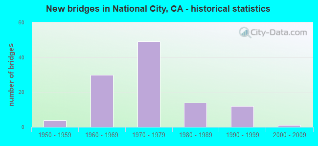
- New bridges - historical statistics
- 41950-1959
- 301960-1969
- 491970-1979
- 141980-1989
- 121990-1999
- 12000-2009
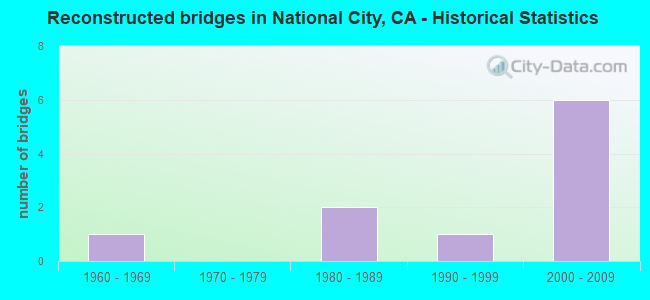
- Reconstructed bridges - Historical Statistics
- 11960-1969
- 01970-1979
- 21980-1989
- 11990-1999
- 62000-2009
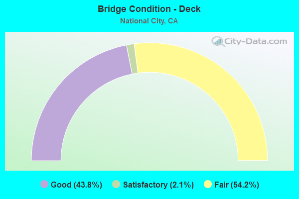
- Bridge Condition - Deck
- 43.8%Good
- 2.1%Satisfactory
- 54.2%Fair
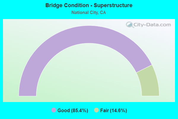
- Bridge Condition - Superstructure
- 85.4%Good
- 14.6%Fair
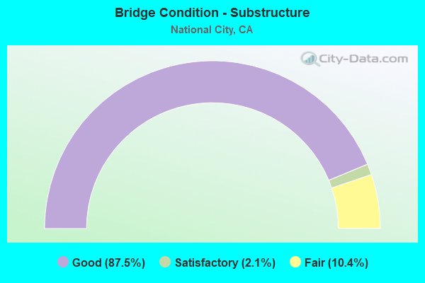
- Bridge Condition - Substructure
- 87.5%Good
- 2.1%Satisfactory
- 10.4%Fair
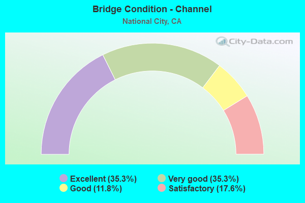
- Bridge Condition - Channel
- 35.3%Excellent
- 35.3%Very good
- 11.8%Good
- 17.6%Satisfactory
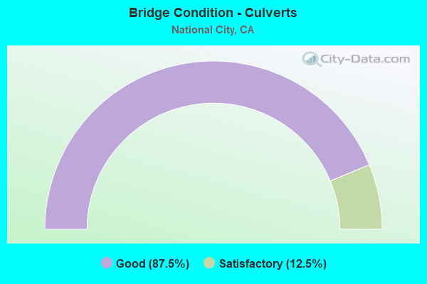
- Bridge Condition - Culverts
- 87.5%Good
- 12.5%Satisfactory
Find on map >> Show street view
Structure Number: 1CA0484, Location: ADJACENT TO GATE #9 (Lat: 32.674467, Lng: -117.115550), Route carried "on" structure: Other road , Year Built: 1969, Status: Open, Structure Length: 2.63m (8.63ft), Average Daily Traffic: 4,000 (year 2015), Truck Traffic: 10%, Average Future Daily Traffic: 4,400 (year 2037), Design Load: HS 20, Features Intersected: PALETA CREEK, Facility Carried by Structure: CUMMINGS ROAD
Minimum Vertical Clearance: 30+ m (98+ ft), Kilometerpoint: 0.000, Lanes on structure: 4, Owner: Navy/Marines, Approaching Roadway Width: 13.7m (44.9ft), Skew: 1 degrees, Material/Design: Concrete continuous, Design/Construction: Slab, Number Of Spans In Main Unit: 5, Length of Maximum Span: 4.7m (15.4ft), Curb or Sidewalk Widths: Left: 1.8m (5.9ft), Right: 0.4m (1.3ft), Curb-To-Curb Width: 13.7m (44.9ft), Out-to-Out Width: 16.6m (54.5ft)
Condition: Deck: Satisfactory, Superstructure: Good, Substructure: Satisfactory, Channel: Good, Operating Rating: 74.5 metric tons, Method Used To Determine Operating Rating: Load Factor (LF), Inventory Rating: 44.7 metric tons, Method Used To Determine Inventory Rating: Load Factor (LF), Structural Evaluation: Equal to present minimum criteria, Deck Geometry: High priority of replacement, Waterway Adequacy: Equal to present desirable criteria, Approach Roadway Alignment: Equal to present minimum criteria, Length Of Structure Improvement: 2.63m (8.63ft), Designated Inspection Frequency: Every 24 months, Inspection Date: July 2021, Bridge Improvement Cost: $50,000, Roadway Improvement Cost: $44,000, Total Project Cost: $94,000 ( Estimate for 2021), Deck Structure Type: Concrete Cast-file-Place, Wearing Surface/Protective System: Wearing Surface: Epoxy Overlay
Find on map >> Show street view
Structure Number: 1CA3102, Location: 3/4MI N OF RECREATION WAY (Lat: 32.678339, Lng: -117.111539), Route carried "on" structure: Other road , Year Built: 1997, Status: Open, Structure Length: 1.13m (3.71ft), Average Daily Traffic: 100 (year 2015), Truck Traffic: 2%, Average Future Daily Traffic: 120 (year 2037), Features Intersected: PALETA CREEK, Facility Carried by Structure: FOURTH STREET
Minimum Vertical Clearance: 30+ m (98+ ft), Kilometerpoint: 0.000, Lanes on structure: 2, Owner: Navy/Marines, Approaching Roadway Width: 8.2m (26.9ft), Material/Design: Concrete, Design/Construction: Culvert, Number Of Spans In Main Unit: 3, Length of Maximum Span: 3.7m (12.1ft), Curb or Sidewalk Widths: Left: 1.2m (3.9ft), Right: 0.2m (0.7ft), Curb-To-Curb Width: 8.2m (26.9ft), Out-to-Out Width: 20.1m (65.9ft)
Condition: Channel: Satisfactory, Culverts: Good, Operating Rating: 36.2 metric tons, Method Used To Determine Operating Rating: Field evaluation and documented engineering judgment, Inventory Rating: 32.6 metric tons, Method Used To Determine Inventory Rating: Field evaluation and documented engineering judgment, Structural Evaluation: Better than present minimum criteria, Deck Geometry: Equal to present minimum criteria, Waterway Adequacy: Equal to present minimum criteria, Approach Roadway Alignment: Equal to present desirable criteria, Length Of Structure Improvement: 1.13m (3.71ft), Designated Inspection Frequency: Every 24 months, Inspection Date: July 2021, Bridge Improvement Cost: $6,000, Roadway Improvement Cost: $3,000, Total Project Cost: $9,000 ( Estimate for 2021)
Find on map >> Show street view
Structure Number: 1CA3103, Location: 1/4MI N OF RECREATION WAY (Lat: 32.681767, Lng: -117.112747), Route carried "on" structure: Other road , Year Built: 1997, Status: Open, Structure Length: 1.24m (4.07ft), Average Daily Traffic: 50 (year 2015), Truck Traffic: 5%, Average Future Daily Traffic: 70 (year 2037), Features Intersected: PALETA CREEK, Facility Carried by Structure: DIVISION STREET
Minimum Vertical Clearance: 30+ m (98+ ft), Kilometerpoint: 0.000, Lanes on structure: 2, Owner: Navy/Marines, Approaching Roadway Width: 4.9m (16.1ft), Skew: 2 degrees, Material/Design: Concrete, Design/Construction: Culvert, Number Of Spans In Main Unit: 3, Length of Maximum Span: 4.0m (13.1ft), Curb or Sidewalk Widths: Left: 1.7m (5.6ft), Right: 1.7m (5.6ft)
Condition: Channel: Satisfactory, Culverts: Good, Operating Rating: 36.2 metric tons, Method Used To Determine Operating Rating: Field evaluation and documented engineering judgment, Inventory Rating: 32.6 metric tons, Method Used To Determine Inventory Rating: Field evaluation and documented engineering judgment, Structural Evaluation: Better than present minimum criteria, Waterway Adequacy: Equal to present minimum criteria, Approach Roadway Alignment: Equal to present desirable criteria, Length Of Structure Improvement: 1.24m (4.07ft), Designated Inspection Frequency: Every 24 months, Inspection Date: July 2021, Bridge Improvement Cost: $7,000, Roadway Improvement Cost: $2,000, Total Project Cost: $9,000 ( Estimate for 2021)
Find on map >> Show street view
Structure Number: 57 0251L, Location: 11-SD-005-R10.04-NATC (Lat: 32.659869, Lng: -117.108000), Route carried "on" structure: Interstate 5, Year Built: 1965, Year Reconstructed: 2007, Status: Open, Structure Length: 4.69m (15.39ft), Average Daily Traffic: 77,000 (year 2020), Truck Traffic: 5%, Average Future Daily Traffic: 117,466 (year 2040), Design Load: HS 20, Features Intersected: 24TH STREET
Minimum Vertical Clearance: 30+ m (98+ ft), Kilometerpoint: 10.040, Lanes on structure: 5, Lanes under structure: 5, Base Highway Network: Yes (, Subroute: 1), Owner: State Highway Agency, Approaching Roadway Width: 23.5m (77.1ft), Skew: 9 degrees, Material/Design: Concrete continuous, Design/Construction: Box Beam or Girders - Multiple, Number Of Spans In Main Unit: 3, Length of Maximum Span: 25.6m (84.0ft), Curb-To-Curb Width: 23.5m (77.1ft), Out-to-Out Width: 24.4m (80.1ft)
Condition: Deck: Fair, Superstructure: Good, Substructure: Good, Operating Rating: 54.1 metric tons, Method Used To Determine Operating Rating: Assigned rating based on Load Factor Design (LFD) reported in metric tons, Inventory Rating: 32.4 metric tons, Method Used To Determine Inventory Rating: Assigned rating based on Load Factor Design (LFD) reported in metric tons, Structural Evaluation: Better than present minimum criteria, Deck Geometry: Equal to present minimum criteria, Underclear: Somewhat better than minimum adequacy, Approach Roadway Alignment: Equal to present desirable criteria, Designated Inspection Frequency: Every 24 months, Inspection Date: June 2021, Deck Structure Type: Concrete Cast-file-Place
Find on map >> Show street view
Structure Number: 57 0251R, Location: 11-SD-005-R10.04-NATC (Lat: 32.659914, Lng: -117.107642), Route carried "on" structure: Interstate 5, Year Built: 1965, Year Reconstructed: 1988, Status: Open, Structure Length: 4.75m (15.58ft), Average Daily Traffic: 77,000 (year 2010), Truck Traffic: 5%, Average Future Daily Traffic: 117,466 (year 2040), Design Load: HS 20, Features Intersected: 24TH STREET
Minimum Vertical Clearance: 30+ m (98+ ft), Kilometerpoint: 10.040, Lanes on structure: 5, Lanes under structure: 5, Base Highway Network: Yes (, Subroute: 1), Owner: State Highway Agency, Approaching Roadway Width: 25.3m (83.0ft), Skew: 9 degrees, Material/Design: Concrete continuous, Design/Construction: Box Beam or Girders - Multiple, Number Of Spans In Main Unit: 3, Length of Maximum Span: 26.2m (86.0ft), Curb-To-Curb Width: 25.4m (83.3ft), Out-to-Out Width: 26.2m (86.0ft)
Condition: Deck: Good, Superstructure: Good, Substructure: Good, Operating Rating: 54.1 metric tons, Method Used To Determine Operating Rating: Assigned rating based on Load Factor Design (LFD) reported in metric tons, Inventory Rating: 32.4 metric tons, Method Used To Determine Inventory Rating: Assigned rating based on Load Factor Design (LFD) reported in metric tons, Structural Evaluation: Better than present minimum criteria, Deck Geometry: Better than present minimum criteria, Underclear: Equal to present minimum criteria, Approach Roadway Alignment: Equal to present desirable criteria, Designated Inspection Frequency: Every 48 months, Inspection Date: June 2019, Deck Structure Type: Concrete Cast-file-Place
Find on map >> Show street view
Structure Number: 57 0252L, Location: 11-SD-005-R10.43-NATC (Lat: 32.665211, Lng: -117.110178), Route carried "on" structure: Interstate 5, Year Built: 1965, Year Reconstructed: 2007, Status: Open, Structure Length: 3.35m (10.99ft), Average Daily Traffic: 82,000 (year 2010), Truck Traffic: 5%, Average Future Daily Traffic: 117,466 (year 2040), Design Load: H 20, Features Intersected: 18TH STREET
Minimum Vertical Clearance: 30+ m (98+ ft), Kilometerpoint: 10.430, Lanes on structure: 5, Lanes under structure: 2, Base Highway Network: Yes (, Subroute: 1), Owner: State Highway Agency, Approaching Roadway Width: 23.6m (77.4ft), Material/Design: Concrete continuous, Design/Construction: Slab, Number Of Spans In Main Unit: 3, Length of Maximum Span: 12.2m (40.0ft), Curb-To-Curb Width: 23.6m (77.4ft), Out-to-Out Width: 24.4m (80.1ft)
Condition: Deck: Good, Superstructure: Good, Substructure: Good, Operating Rating: 81.3 metric tons, Method Used To Determine Operating Rating: Load Factor (LF), Inventory Rating: 48.9 metric tons, Method Used To Determine Inventory Rating: Load Factor (LF), Structural Evaluation: Better than present minimum criteria, Deck Geometry: Equal to present minimum criteria, Underclear: Somewhat better than minimum adequacy, Approach Roadway Alignment: Equal to present desirable criteria, Designated Inspection Frequency: Every 48 months, Inspection Date: June 2019, Deck Structure Type: Concrete Cast-file-Place
Find on map >> Show street view
Structure Number: 57 0252R, Location: 11-SD-005-R10.43-NATC (Lat: 32.665328, Lng: -117.109808), Route carried "on" structure: Interstate 5, Year Built: 1951, Year Reconstructed: 1965, Status: Open, Structure Length: 3.14m (10.30ft), Average Daily Traffic: 82,000 (year 2010), Truck Traffic: 5%, Average Future Daily Traffic: 117,466 (year 2040), Design Load: H 20, Features Intersected: 18TH STREET
Minimum Vertical Clearance: 30+ m (98+ ft), Kilometerpoint: 10.430, Lanes on structure: 6, Lanes under structure: 2, Base Highway Network: Yes (, Subroute: 1), Owner: State Highway Agency, Approaching Roadway Width: 29.2m (95.8ft), Material/Design: Concrete continuous, Design/Construction: Slab, Number Of Spans In Main Unit: 3, Length of Maximum Span: 12.2m (40.0ft), Curb-To-Curb Width: 29.2m (95.8ft), Out-to-Out Width: 30.4m (99.7ft)
Condition: Deck: Good, Superstructure: Good, Substructure: Good, Operating Rating: 77.8 metric tons, Method Used To Determine Operating Rating: Load Factor (LF), Inventory Rating: 46.7 metric tons, Method Used To Determine Inventory Rating: Load Factor (LF), Structural Evaluation: Better than present minimum criteria, Deck Geometry: Better than present minimum criteria, Underclear: Somewhat better than minimum adequacy, Approach Roadway Alignment: Equal to present desirable criteria, Designated Inspection Frequency: Every 48 months, Inspection Date: June 2019, Deck Structure Type: Concrete Cast-file-Place, Wearing Surface/Protective System: Wearing Surface: Bituminous
Find on map >> Show street view
Structure Number: 57 046, Location: 11-SD-005-R44.07-CBD (Lat: 33.084033, Lng: -117.298458), Route carried "on" structure: County highway S347, Year Built: 1965, Year Reconstructed: 1997, Status: Open, Structure Length: 6.74m (22.11ft), Average Daily Traffic: 30,151 (year 2020), Truck Traffic: 2%, Average Future Daily Traffic: 37,403 (year 2040), Design Load: HS 20, Features Intersected: INTERSTATE 5, Facility Carried by Structure: LA COSTA AVE
Minimum Vertical Clearance: 30+ m (98+ ft), Kilometerpoint: 0.000, Lanes on structure: 6, Lanes under structure: 8, Base Highway Network: Yes, Owner: State Highway Agency, Approaching Roadway Width: 28.7m (94.2ft), Skew: 1 degrees, Material/Design: Concrete continuous, Design/Construction: Box Beam or Girders - Multiple, Number Of Spans In Main Unit: 2, Length of Maximum Span: 34.1m (111.9ft), Curb or Sidewalk Widths: Left: 1.5m (4.9ft), Right: 1.5m (4.9ft), Curb-To-Curb Width: 28.7m (94.2ft), Out-to-Out Width: 32.3m (106.0ft)
Condition: Deck: Good, Superstructure: Good, Substructure: Good, Operating Rating: 82.3 metric tons, Method Used To Determine Operating Rating: Load Factor (LF), Inventory Rating: 49.6 metric tons, Method Used To Determine Inventory Rating: Load Factor (LF), Structural Evaluation: Better than present minimum criteria, Deck Geometry: Superior to present desirable criteria, Underclear: Meets minimum limits, Approach Roadway Alignment: Equal to present minimum criteria, Designated Inspection Frequency: Every 24 months, Inspection Date: March 2021, Deck Structure Type: Concrete Cast-file-Place
Find on map >> Show street view
Structure Number: 57 0464L, Location: 11-SD-005-R10.39-NATC (Lat: 32.664600, Lng: -117.109928), Route carried "on" structure: Interstate 5, Year Built: 1965, Year Reconstructed: 2006, Status: Open, Structure Length: 3.99m (13.09ft), Average Daily Traffic: 82,000 (year 2020), Truck Traffic: 5%, Average Future Daily Traffic: 117,466 (year 2040), Design Load: H 20, Features Intersected: 19TH STREET
Minimum Vertical Clearance: 30+ m (98+ ft), Kilometerpoint: 10.390, Lanes on structure: 5, Lanes under structure: 2, Base Highway Network: Yes (, Subroute: 1), Owner: State Highway Agency, Approaching Roadway Width: 23.6m (77.4ft), Skew: 3 degrees, Material/Design: Concrete continuous, Design/Construction: Slab, Number Of Spans In Main Unit: 3, Length of Maximum Span: 14.3m (46.9ft), Curb-To-Curb Width: 23.6m (77.4ft), Out-to-Out Width: 24.4m (80.1ft)
Condition: Deck: Fair, Superstructure: Fair, Substructure: Good, Operating Rating: 45.7 metric tons, Method Used To Determine Operating Rating: Load Factor (LF), Inventory Rating: 27.5 metric tons, Method Used To Determine Inventory Rating: Load Factor (LF), Structural Evaluation: Somewhat better than minimum adequacy, Deck Geometry: Equal to present minimum criteria, Underclear: Meets minimum limits, Approach Roadway Alignment: Equal to present desirable criteria, Designated Inspection Frequency: Every 24 months, Inspection Date: June 2021, Deck Structure Type: Concrete Cast-file-Place
Find on map >> Show street view
Structure Number: 57 0464R, Location: 11-SD-005-R10.39-NATC (Lat: 32.664897, Lng: -117.109650), Route carried "on" structure: Interstate 5, Year Built: 1965, Year Reconstructed: 2006, Status: Open, Structure Length: 3.57m (11.71ft), Average Daily Traffic: 82,000 (year 2010), Truck Traffic: 5%, Average Future Daily Traffic: 117,466 (year 2040), Design Load: H 20, Features Intersected: 19TH STREET
Minimum Vertical Clearance: 30+ m (98+ ft), Kilometerpoint: 10.390, Lanes on structure: 6, Lanes under structure: 2, Base Highway Network: Yes (, Subroute: 1), Owner: State Highway Agency, Approaching Roadway Width: 27.3m (89.6ft), Skew: 3 degrees, Material/Design: Concrete continuous, Design/Construction: Slab, Number Of Spans In Main Unit: 3, Length of Maximum Span: 14.3m (46.9ft), Curb-To-Curb Width: 27.3m (89.6ft), Out-to-Out Width: 28.1m (92.2ft)
Condition: Deck: Good, Superstructure: Good, Substructure: Good, Operating Rating: 74.8 metric tons, Method Used To Determine Operating Rating: Load Factor (LF), Inventory Rating: 45.0 metric tons, Method Used To Determine Inventory Rating: Load Factor (LF), Structural Evaluation: Better than present minimum criteria, Deck Geometry: Equal to present minimum criteria, Underclear: Meets minimum limits, Approach Roadway Alignment: Superior to present desirable criteria, Designated Inspection Frequency: Every 48 months, Inspection Date: June 2019, Deck Structure Type: Concrete Cast-file-Place
Find on map >> Show street view
Structure Number: 57 0467L, Location: 11-SD-005-R10.68-NATC (Lat: 32.668506, Lng: -117.111339), Route carried "on" structure: Interstate 5, Year Built: 1964, Status: Open, Structure Length: 4.75m (15.58ft), Average Daily Traffic: 82,000 (year 2020), Truck Traffic: 5%, Average Future Daily Traffic: 117,466 (year 2040), Design Load: H 20, Features Intersected: N5-HARBOR DR OFF-RAMP
Minimum Vertical Clearance: 30+ m (98+ ft), Kilometerpoint: 10.680, Lanes on structure: 4, Lanes under structure: 2, Base Highway Network: Yes (, Subroute: 1), Owner: State Highway Agency, Approaching Roadway Width: 20.1m (65.9ft), Skew: 9 degrees, Material/Design: Concrete continuous, Design/Construction: Box Beam or Girders - Multiple, Number Of Spans In Main Unit: 3, Length of Maximum Span: 17.7m (58.1ft), Curb-To-Curb Width: 20.1m (65.9ft), Out-to-Out Width: 20.9m (68.6ft)
Condition: Deck: Fair, Superstructure: Good, Substructure: Good, Operating Rating: 44.7 metric tons, Method Used To Determine Operating Rating: Load and Resistance Factor Rating (LRFR) rating reported by rating factor(RF) method using HL-93 loadings, Inventory Rating: 34.7 metric tons, Method Used To Determine Inventory Rating: Load and Resistance Factor Rating (LRFR) rating reported by rating factor(RF) method using HL-93 loadings, Structural Evaluation: Better than present minimum criteria, Deck Geometry: Equal to present minimum criteria, Underclear: Superior to present desirable criteria, Approach Roadway Alignment: Superior to present desirable criteria, Designated Inspection Frequency: Every 24 months, Inspection Date: June 2021, Deck Structure Type: Concrete Cast-file-Place
Find on map >> Show street view
Structure Number: 57 0467R, Location: 11-SD-005-R10.68-NATC (Lat: 32.668225, Lng: -117.110983), Route carried "on" structure: Interstate 5, Year Built: 1964, Status: Open, Structure Length: 4.82m (15.81ft), Average Daily Traffic: 82,000 (year 2020), Truck Traffic: 5%, Average Future Daily Traffic: 117,466 (year 2040), Design Load: H 20, Features Intersected: N5-HARBOR DR OFF-RAMP
Minimum Vertical Clearance: 30+ m (98+ ft), Kilometerpoint: 10.680, Lanes on structure: 4, Lanes under structure: 2, Base Highway Network: Yes (, Subroute: 1), Owner: State Highway Agency, Approaching Roadway Width: 20.1m (65.9ft), Skew: 9 degrees, Material/Design: Concrete continuous, Design/Construction: Box Beam or Girders - Multiple, Number Of Spans In Main Unit: 3, Length of Maximum Span: 18.9m (62.0ft), Curb or Sidewalk Widths: Left: 0.0m, Right: 0.6m (2.0ft), Curb-To-Curb Width: 20.1m (65.9ft), Out-to-Out Width: 21.3m (69.9ft)
Condition: Deck: Good, Superstructure: Good, Substructure: Good, Operating Rating: 53.5 metric tons, Method Used To Determine Operating Rating: Load and Resistance Factor Rating (LRFR) rating reported by rating factor(RF) method using HL-93 loadings, Inventory Rating: 41.1 metric tons, Method Used To Determine Inventory Rating: Load and Resistance Factor Rating (LRFR) rating reported by rating factor(RF) method using HL-93 loadings, Structural Evaluation: Better than present minimum criteria, Deck Geometry: Equal to present minimum criteria, Underclear: Somewhat better than minimum adequacy, Approach Roadway Alignment: Equal to present desirable criteria, Designated Inspection Frequency: Every 24 months, Inspection Date: June 2021, Deck Structure Type: Concrete Cast-file-Place
Find on map >> Show street view
Structure Number: 57 0468K, Location: 11-SD-005-R10.72-NATC (Lat: 32.668917, Lng: -117.112289), Route carried "on" structure: Ramp Interstate 5, Year Built: 1964, Status: Open, Structure Length: 11.58m (37.99ft), Average Daily Traffic: 5,600 (year 2020), Truck Traffic: 1%, Average Future Daily Traffic: 8,655 (year 2040), Design Load: H 20, Features Intersected: I 5 ON&OFFRMP,CIVIC CENT
Minimum Vertical Clearance: 30+ m (98+ ft), Kilometerpoint: 10.720, Lanes on structure: 1, Lanes under structure: 5, Owner: State Highway Agency, Approaching Roadway Width: 6.7m (22.0ft), Skew: 9 degrees, Material/Design: Concrete continuous, Design/Construction: Box Beam or Girders - Multiple, Number Of Spans In Main Unit: 4, Length of Maximum Span: 33.5m (109.9ft), Curb or Sidewalk Widths: Left: 0.0m, Right: 0.6m (2.0ft), Curb-To-Curb Width: 6.7m (22.0ft), Out-to-Out Width: 8.0m (26.2ft)
Condition: Deck: Fair, Superstructure: Good, Substructure: Good, Operating Rating: 82.3 metric tons, Method Used To Determine Operating Rating: Load Factor (LF), Inventory Rating: 49.6 metric tons, Method Used To Determine Inventory Rating: Load Factor (LF), Structural Evaluation: Better than present minimum criteria, Deck Geometry: Equal to present minimum criteria, Underclear: Meets minimum limits, Approach Roadway Alignment: Equal to present desirable criteria, Designated Inspection Frequency: Every 24 months, Inspection Date: June 2021, Deck Structure Type: Concrete Cast-file-Place
Find on map >> Show street view
Structure Number: 57 0468L, Location: 11-SD-005-R10.75-NATC (Lat: 32.669514, Lng: -117.111439), Route carried "on" structure: Interstate 5, Year Built: 1964, Status: Open, Structure Length: 17.10m (56.10ft), Average Daily Traffic: 82,000 (year 2020), Truck Traffic: 5%, Average Future Daily Traffic: 117,466 (year 2040), Design Load: HS 20+Mod, Features Intersected: MTDB LRT, SDIV RR, CIVIC
Minimum Vertical Clearance: 5.50m (18.04ft), Kilometerpoint: 10.750, Lanes on structure: 4, Lanes under structure: 2, Base Highway Network: Yes (, Subroute: 1), Owner: State Highway Agency, Approaching Roadway Width: 23.2m (76.1ft), Skew: 9 degrees, Material/Design: Concrete continuous, Design/Construction: Box Beam or Girders - Multiple, Number Of Spans In Main Unit: 6, Length of Maximum Span: 33.5m (109.9ft), Curb-To-Curb Width: 23.2m (76.1ft), Out-to-Out Width: 24.0m (78.7ft)
Condition: Deck: Fair, Superstructure: Good, Substructure: Good, Operating Rating: 77.8 metric tons, Method Used To Determine Operating Rating: Load Factor (LF), Inventory Rating: 46.7 metric tons, Method Used To Determine Inventory Rating: Load Factor (LF), Structural Evaluation: Better than present minimum criteria, Deck Geometry: Superior to present desirable criteria, Underclear: Equal to present minimum criteria, Approach Roadway Alignment: Equal to present desirable criteria, Designated Inspection Frequency: Every 24 months, Inspection Date: June 2021, Deck Structure Type: Concrete Cast-file-Place
Find on map >> Show street view
Structure Number: 57 0468R, Location: 11-SD-005-R10.75-NATC (Lat: 32.669517, Lng: -117.111181), Route carried "on" structure: Interstate 5, Year Built: 1964, Status: Open, Structure Length: 14.08m (46.19ft), Average Daily Traffic: 82,000 (year 2020), Truck Traffic: 5%, Average Future Daily Traffic: 117,466 (year 2040), Design Load: HS 20+Mod, Features Intersected: MTDB LRT, SDIV RR, CIVIC
Minimum Vertical Clearance: 5.70m (18.70ft), Kilometerpoint: 10.750, Lanes on structure: 4, Lanes under structure: 2, Base Highway Network: Yes (, Subroute: 1), Owner: State Highway Agency, Approaching Roadway Width: 20.2m (66.3ft), Skew: 9 degrees, Material/Design: Concrete continuous, Design/Construction: Box Beam or Girders - Multiple, Number Of Spans In Main Unit: 5, Length of Maximum Span: 32.9m (107.9ft), Curb-To-Curb Width: 20.2m (66.3ft), Out-to-Out Width: 21.0m (68.9ft)
Condition: Deck: Fair, Superstructure: Good, Substructure: Good, Operating Rating: 77.8 metric tons, Method Used To Determine Operating Rating: Load Factor (LF), Inventory Rating: 46.7 metric tons, Method Used To Determine Inventory Rating: Load Factor (LF), Structural Evaluation: Better than present minimum criteria, Deck Geometry: Equal to present minimum criteria, Underclear: Equal to present minimum criteria, Approach Roadway Alignment: Equal to present desirable criteria, Designated Inspection Frequency: Every 24 months, Inspection Date: June 2021, Deck Structure Type: Concrete Cast-file-Place
Find on map >> Show street view
Structure Number: 57 0468S, Location: 11-SD-005-R10.75-NATC (Lat: 32.669522, Lng: -117.111069), Route carried "on" structure: Ramp Interstate 5, Year Built: 1964, Status: Open, Structure Length: 17.22m (56.50ft), Average Daily Traffic: 5,600 (year 2020), Truck Traffic: 5%, Average Future Daily Traffic: 8,655 (year 2040), Design Load: HS 20+Mod, Features Intersected: MTDB LRT, SDIV RR, CIVIC
Minimum Vertical Clearance: 5.90m (19.36ft), Kilometerpoint: 10.750, Lanes on structure: 1, Lanes under structure: 3, Base Highway Network: Yes, Owner: State Highway Agency, Approaching Roadway Width: 6.7m (22.0ft), Skew: 9 degrees, Material/Design: Concrete continuous, Design/Construction: Box Beam or Girders - Multiple, Number Of Spans In Main Unit: 6, Length of Maximum Span: 37.2m (122.0ft), Curb or Sidewalk Widths: Left: 0.6m (2.0ft), Right: 0.0m, Curb-To-Curb Width: 6.7m (22.0ft), Out-to-Out Width: 8.0m (26.2ft)
Condition: Deck: Good, Superstructure: Good, Substructure: Good, Operating Rating: 68.0 metric tons, Method Used To Determine Operating Rating: Load Factor (LF), Inventory Rating: 40.8 metric tons, Method Used To Determine Inventory Rating: Load Factor (LF), Structural Evaluation: Better than present minimum criteria, Deck Geometry: Equal to present minimum criteria, Underclear: Meets minimum limits, Approach Roadway Alignment: Equal to present desirable criteria, Designated Inspection Frequency: Every 24 months, Inspection Date: June 2021, Deck Structure Type: Concrete Cast-file-Place
Find on map >> Show street view
Structure Number: 57 0469, Location: 11-SD-005-R11.13-NATC (Lat: 32.674886, Lng: -117.109469), Route carried "on" structure: Interstate 5, Year Built: 1964, Status: Open, Structure Length: 6.16m (20.21ft), Average Daily Traffic: 164,000 (year 2020), Truck Traffic: 5%, Average Future Daily Traffic: 234,932 (year 2040), Design Load: H 20, Features Intersected: 8TH STREET
Minimum Vertical Clearance: 30+ m (98+ ft), Kilometerpoint: 11.130, Lanes on structure: 9, Lanes under structure: 5, Base Highway Network: Yes (, Subroute: 1), Owner: State Highway Agency, Approaching Roadway Width: 48.8m (160.1ft), Skew: 13 degrees, Material/Design: Concrete continuous, Design/Construction: Box Beam or Girders - Multiple, Number Of Spans In Main Unit: 3, Length of Maximum Span: 31.7m (104.0ft), Curb-To-Curb Width: 48.8m (160.1ft), Out-to-Out Width: 50.0m (164.0ft)
Condition: Deck: Fair, Superstructure: Good, Substructure: Good, Operating Rating: 83.9 metric tons, Method Used To Determine Operating Rating: Load Factor (LF), Inventory Rating: 50.2 metric tons, Method Used To Determine Inventory Rating: Load Factor (LF), Structural Evaluation: Better than present minimum criteria, Deck Geometry: Superior to present desirable criteria, Underclear: Somewhat better than minimum adequacy, Approach Roadway Alignment: Equal to present desirable criteria, Length Of Structure Improvement: 6.16m (20.21ft), Designated Inspection Frequency: Every 24 months, Inspection Date: June 2021, Deck Structure Type: Concrete Cast-file-Place
Find on map >> Show street view
Structure Number: 57 0483, Location: 11-SD-005-R10.01-NATC (Lat: 32.659539, Lng: -117.107319), Route carried "on" structure: Interstate 5, Year Built: 1965, Year Reconstructed: 1989, Status: Open, Structure Length: 1.10m (3.61ft), Average Daily Traffic: 154,000 (year 2010), Truck Traffic: 5%, Average Future Daily Traffic: 234,932 (year 2040), Features Intersected: PARADISE CREEK
Minimum Vertical Clearance: 30+ m (98+ ft), Kilometerpoint: 10.010, Lanes on structure: 14, Base Highway Network: Yes (, Subroute: 1), Owner: State Highway Agency, Approaching Roadway Width: 68.6m (225.1ft), Skew: 29 degrees, Material/Design: Concrete, Design/Construction: Culvert, Number Of Spans In Main Unit: 4, Length of Maximum Span: 2.4m (7.9ft), Curb-To-Curb Width: 68.6m (225.1ft), Out-to-Out Width: 80.0m (262.5ft)
Condition: Channel: Very good, Culverts: Satisfactory, Operating Rating: 54.1 metric tons, Method Used To Determine Operating Rating: Field evaluation and documented engineering judgment, Inventory Rating: 32.4 metric tons, Method Used To Determine Inventory Rating: Field evaluation and documented engineering judgment, Structural Evaluation: Equal to present minimum criteria, Deck Geometry: Superior to present desirable criteria, Waterway Adequacy: Equal to present desirable criteria, Approach Roadway Alignment: Equal to present desirable criteria, Designated Inspection Frequency: Every 48 months, Inspection Date: June 2019
Find on map >> Show street view
Structure Number: 57 063, Location: 11-SD-008-R34.33 (Lat: 32.838536, Lng: -116.681169), Route carried "on" structure: County highway , Year Built: 1969, Status: Open, Structure Length: 7.59m (24.90ft), Average Daily Traffic: 500 (year 2010), Truck Traffic: 1%, Average Future Daily Traffic: 1,077 (year 2044), Design Load: HS 20, Features Intersected: INTERSTATE 8, Facility Carried by Structure: WILLOWS RD
Minimum Vertical Clearance: 30+ m (98+ ft), Kilometerpoint: 0.000, Lanes on structure: 2, Lanes under structure: 5, Owner: State Highway Agency, Approaching Roadway Width: 12.2m (40.0ft), Skew: 1 degrees, Material/Design: Concrete continuous, Design/Construction: Box Beam or Girders - Multiple, Number Of Spans In Main Unit: 2, Length of Maximum Span: 41.1m (134.8ft), Curb-To-Curb Width: 12.2m (40.0ft), Out-to-Out Width: 12.8m (42.0ft)
Condition: Deck: Good, Superstructure: Fair, Substructure: Good, Operating Rating: 47.6 metric tons, Method Used To Determine Operating Rating: Load and Resistance Factor Rating (LRFR) rating reported by rating factor(RF) method using HL-93 loadings, Inventory Rating: 36.6 metric tons, Method Used To Determine Inventory Rating: Load and Resistance Factor Rating (LRFR) rating reported by rating factor(RF) method using HL-93 loadings, Structural Evaluation: Somewhat better than minimum adequacy, Deck Geometry: Equal to present desirable criteria, Underclear: Equal to present minimum criteria, Approach Roadway Alignment: Equal to present desirable criteria, Designated Inspection Frequency: Every 24 months, Inspection Date: January 2022, Deck Structure Type: Concrete Cast-file-Place
Find on map >> Show street view
Structure Number: 57 0639, Location: 11-SD-805-9.04-NATC (Lat: 32.660908, Lng: -117.076819), Route carried "on" structure: Interstate 805, Year Built: 1974, Year Reconstructed: 2014, Status: Open, Structure Length: 8.44m (27.69ft), Average Daily Traffic: 215,000 (year 2016), Truck Traffic: 6%, Average Future Daily Traffic: 308,000 (year 2038), Design Load: HS 20, Features Intersected: SWEETWATER RD
Minimum Vertical Clearance: 30+ m (98+ ft), Kilometerpoint: 9.040, Lanes on structure: 10, Lanes under structure: 5, Base Highway Network: Yes (Inventory Route: 8, Subroute: 1), Owner: State Highway Agency, Approaching Roadway Width: 24.4m (80.1ft), Skew: 35 degrees, Material/Design: Prestressed concrete continuous, Design/Construction: Box Beam or Girders - Multiple, Number Of Spans In Main Unit: 3, Length of Maximum Span: 47.9m (157.2ft), Curb-To-Curb Width: 48.8m (160.1ft), Out-to-Out Width: 50.0m (164.0ft)
Condition: Deck: Fair, Superstructure: Good, Substructure: Fair, Operating Rating: 95.6 metric tons, Method Used To Determine Operating Rating: Load Factor (LF), Inventory Rating: 32.4 metric tons, Method Used To Determine Inventory Rating: Load Factor (LF), Structural Evaluation: Somewhat better than minimum adequacy, Deck Geometry: Superior to present desirable criteria, Underclear: Somewhat better than minimum adequacy, Approach Roadway Alignment: Equal to present desirable criteria, Designated Inspection Frequency: Every 24 months, Inspection Date: July 2020, Deck Structure Type: Concrete Cast-file-Place
Find on map >> Show street view
Structure Number: 57 0639K, Location: 11-SD-805-9.06-NATC (Lat: 32.660981, Lng: -117.077386), Route carried "on" structure: Ramp Interstate 805, Year Built: 1974, Status: Open, Structure Length: 7.50m (24.61ft), Average Daily Traffic: 6,900 (year 2016), Truck Traffic: 4%, Average Future Daily Traffic: 7,189 (year 2038), Design Load: HS 20, Features Intersected: SWEETWATER RD
Minimum Vertical Clearance: 30+ m (98+ ft), Kilometerpoint: 9.060, Lanes on structure: 1, Lanes under structure: 4, Base Highway Network: Yes (Inventory Route: 8, Subroute: 1), Owner: State Highway Agency, Approaching Roadway Width: 7.3m (24.0ft), Skew: 4 degrees, Material/Design: Prestressed concrete continuous, Design/Construction: Box Beam or Girders - Multiple, Number Of Spans In Main Unit: 3, Length of Maximum Span: 40.8m (133.9ft), Curb-To-Curb Width: 7.3m (24.0ft), Out-to-Out Width: 7.9m (25.9ft)
Condition: Deck: Fair, Superstructure: Good, Substructure: Good, Operating Rating: 89.7 metric tons, Method Used To Determine Operating Rating: Load Factor (LF), Inventory Rating: 32.4 metric tons, Method Used To Determine Inventory Rating: Load Factor (LF), Structural Evaluation: Better than present minimum criteria, Deck Geometry: Better than present minimum criteria, Underclear: High priority of corrective action, Approach Roadway Alignment: Equal to present desirable criteria, Designated Inspection Frequency: Every 24 months, Inspection Date: July 2020, Deck Structure Type: Concrete Cast-file-Place
Find on map >> Show street view
Structure Number: 57 0640F, Location: 11-SD-805-9.07-NATC (Lat: 32.661136, Lng: -117.077900), Route carried "on" structure: Ramp Interstate 805, Year Built: 1974, Status: Open, Structure Length: 20.42m (66.99ft), Average Daily Traffic: 23,500 (year 2016), Truck Traffic: 2%, Average Future Daily Traffic: 26,107 (year 2038), Design Load: HS 20, Features Intersected: EUCLID AV, SWEETWATER RD
Minimum Vertical Clearance: 7.62m (25.00ft), Kilometerpoint: 9.070, Lanes on structure: 2, Lanes under structure: 9, Base Highway Network: Yes (Inventory Route: 8, Subroute: 1), Owner: State Highway Agency, Approaching Roadway Width: 12.2m (40.0ft), Skew: 9 degrees, Material/Design: Prestressed concrete continuous, Design/Construction: Box Beam or Girders - Multiple, Number Of Spans In Main Unit: 6, Number Of Approach Spans: 1, Length of Maximum Span: 41.5m (136.2ft), Curb-To-Curb Width: 12.3m (40.4ft), Out-to-Out Width: 12.9m (42.3ft)
Condition: Deck: Good, Superstructure: Good, Substructure: Good, Operating Rating: 99.8 metric tons, Method Used To Determine Operating Rating: Load Factor (LF), Inventory Rating: 32.4 metric tons, Method Used To Determine Inventory Rating: Load Factor (LF), Structural Evaluation: Better than present minimum criteria, Deck Geometry: Superior to present desirable criteria, Underclear: High priority of corrective action, Approach Roadway Alignment: Equal to present desirable criteria, Designated Inspection Frequency: Every 24 months, Inspection Date: July 2020, Deck Structure Type: Concrete Cast-file-Place
Find on map >> Show street view
Structure Number: 57 0641, Location: 11-SD-805-9.99-NATC (Lat: 32.673103, Lng: -117.082569), Route carried "on" structure: City street S199, Year Built: 1974, Status: Open, Structure Length: 8.29m (27.20ft), Average Daily Traffic: 15,700 (year 2016), Truck Traffic: 1%, Average Future Daily Traffic: 18,485 (year 2038), Design Load: HS 20, Features Intersected: INTERSTATE 805, Facility Carried by Structure: 18TH ST
Minimum Vertical Clearance: 30+ m (98+ ft), Kilometerpoint: 0.000, Lanes on structure: 2, Lanes under structure: 12, Owner: State Highway Agency, Approaching Roadway Width: 12.2m (40.0ft), Material/Design: Prestressed concrete continuous, Design/Construction: Box Beam or Girders - Multiple, Number Of Spans In Main Unit: 2, Length of Maximum Span: 45.4m (149.0ft), Curb or Sidewalk Widths: Left: 1.5m (4.9ft), Right: 1.5m (4.9ft), Curb-To-Curb Width: 12.2m (40.0ft), Out-to-Out Width: 15.8m (51.8ft)
Condition: Deck: Fair, Superstructure: Good, Substructure: Good, Operating Rating: 69.0 metric tons, Method Used To Determine Operating Rating: Load and Resistance Factor Rating (LRFR) rating reported by rating factor(RF) method using HL-93 loadings, Inventory Rating: 42.4 metric tons, Method Used To Determine Inventory Rating: Load and Resistance Factor Rating (LRFR) rating reported by rating factor(RF) method using HL-93 loadings, Structural Evaluation: Better than present minimum criteria, Deck Geometry: Somewhat better than minimum adequacy, Underclear: Meets minimum limits, Approach Roadway Alignment: Equal to present desirable criteria, Designated Inspection Frequency: Every 24 months, Inspection Date: July 2020, Deck Structure Type: Concrete Cast-file-Place
Find on map >> Show street view
Structure Number: 57 0642, Location: 11-SD-805-10.11-NATC (Lat: 32.674808, Lng: -117.083353), Route carried "on" structure: City street S200, Year Built: 1974, Status: Open, Structure Length: 9.33m (30.61ft), Average Daily Traffic: 9,880 (year 2016), Truck Traffic: 1%, Average Future Daily Traffic: 15,405 (year 2038), Design Load: HS 20, Features Intersected: INTERSTATE 805 & RAMPS, Facility Carried by Structure: 16TH STREET
Minimum Vertical Clearance: 30+ m (98+ ft), Kilometerpoint: 0.000, Lanes on structure: 2, Lanes under structure: 13, Owner: State Highway Agency, Approaching Roadway Width: 12.2m (40.0ft), Material/Design: Prestressed concrete continuous, Design/Construction: Box Beam or Girders - Multiple, Number Of Spans In Main Unit: 2, Length of Maximum Span: 49.4m (162.1ft), Curb or Sidewalk Widths: Left: 1.5m (4.9ft), Right: 1.5m (4.9ft), Curb-To-Curb Width: 12.2m (40.0ft), Out-to-Out Width: 15.8m (51.8ft)
Condition: Deck: Fair, Superstructure: Good, Substructure: Good, Operating Rating: 63.8 metric tons, Method Used To Determine Operating Rating: Load and Resistance Factor Rating (LRFR) rating reported by rating factor(RF) method using HL-93 loadings, Inventory Rating: 42.4 metric tons, Method Used To Determine Inventory Rating: Load and Resistance Factor Rating (LRFR) rating reported by rating factor(RF) method using HL-93 loadings, Structural Evaluation: Better than present minimum criteria, Deck Geometry: Somewhat better than minimum adequacy, Underclear: High priority of corrective action, Approach Roadway Alignment: Equal to present desirable criteria, Designated Inspection Frequency: Every 24 months, Inspection Date: July 2020, Deck Structure Type: Concrete Cast-file-Place
Find on map >> Show street view
Structure Number: 57 0643, Location: 11-SD-805-10.28-NATC (Lat: 32.677219, Lng: -117.084614), Route carried "on" structure: Interstate 805, Year Built: 1975, Status: Open, Structure Length: 4.63m (15.19ft), Average Daily Traffic: 238,000 (year 2018), Truck Traffic: 6%, Average Future Daily Traffic: 308,000 (year 2038), Design Load: HS 20, Features Intersected: PLAZA BLVD
Minimum Vertical Clearance: 30+ m (98+ ft), Kilometerpoint: 10.280, Lanes on structure: 12, Lanes under structure: 6, Base Highway Network: Yes (Inventory Route: 8, Subroute: 1), Owner: State Highway Agency, Approaching Roadway Width: 51.8m (169.9ft), Skew: 30 degrees, Material/Design: Prestressed concrete, Design/Construction: Box Beam or Girders - Multiple, Number Of Spans In Main Unit: 1, Length of Maximum Span: 46.3m (151.9ft), Curb-To-Curb Width: 51.2m (168.0ft), Out-to-Out Width: 52.4m (171.9ft)
Condition: Deck: Fair, Superstructure: Fair, Substructure: Good, Operating Rating: 54.8 metric tons, Method Used To Determine Operating Rating: Load and Resistance Factor Rating (LRFR) rating reported by rating factor(RF) method using HL-93 loadings, Inventory Rating: 35.0 metric tons, Method Used To Determine Inventory Rating: Load and Resistance Factor Rating (LRFR) rating reported by rating factor(RF) method using HL-93 loadings, Structural Evaluation: Somewhat better than minimum adequacy, Deck Geometry: Better than present minimum criteria, Underclear: High priority of corrective action, Approach Roadway Alignment: Equal to present desirable criteria, Designated Inspection Frequency: Every 24 months, Inspection Date: July 2020, Deck Structure Type: Concrete Cast-file-Place
Find on map >> Show street view
Structure Number: 57 0644, Location: 11-SD-805-10.61-NATC (Lat: 32.681497, Lng: -117.086778), Route carried "on" structure: Interstate 805, Year Built: 1975, Status: Open, Structure Length: 3.72m (12.20ft), Average Daily Traffic: 243,000 (year 2016), Truck Traffic: 6%, Average Future Daily Traffic: 308,000 (year 2038), Design Load: HS 20, Features Intersected: 8TH STREET
Minimum Vertical Clearance: 30+ m (98+ ft), Kilometerpoint: 10.610, Lanes on structure: 13, Lanes under structure: 3, Base Highway Network: Yes (Inventory Route: 8, Subroute: 1), Owner: State Highway Agency, Approaching Roadway Width: 55.5m (182.1ft), Skew: 30 degrees, Material/Design: Prestressed concrete, Design/Construction: Box Beam or Girders - Multiple, Number Of Spans In Main Unit: 1, Length of Maximum Span: 37.2m (122.0ft), Curb-To-Curb Width: 54.7m (179.5ft), Out-to-Out Width: 56.1m (184.1ft)
Condition: Deck: Fair, Superstructure: Fair, Substructure: Good, Operating Rating: 43.7 metric tons, Method Used To Determine Operating Rating: Load and Resistance Factor Rating (LRFR) rating reported by rating factor(RF) method using HL-93 loadings, Inventory Rating: 30.1 metric tons, Method Used To Determine Inventory Rating: Load and Resistance Factor Rating (LRFR) rating reported by rating factor(RF) method using HL-93 loadings, Structural Evaluation: Somewhat better than minimum adequacy, Deck Geometry: Better than present minimum criteria, Underclear: Equal to present minimum criteria, Approach Roadway Alignment: Equal to present desirable criteria, Designated Inspection Frequency: Every 24 months, Inspection Date: July 2020, Deck Structure Type: Concrete Cast-file-Place
Find on map >> Show street view
Structure Number: 57 0645, Location: 11-SD-805-10.88-NATC (Lat: 32.684608, Lng: -117.089300), Route carried "on" structure: City street S203, Year Built: 1975, Status: Open, Structure Length: 9.44m (30.97ft), Average Daily Traffic: 8,950 (year 2016), Truck Traffic: 3%, Average Future Daily Traffic: 10,270 (year 2038), Design Load: HS 20+Mod, Features Intersected: INTERSTATE 805, Facility Carried by Structure: 4TH ST
Minimum Vertical Clearance: 30+ m (98+ ft), Kilometerpoint: 0.000, Lanes on structure: 3, Lanes under structure: 14, Owner: State Highway Agency, Approaching Roadway Width: 19.5m (64.0ft), Skew: 2 degrees, Material/Design: Prestressed concrete continuous, Design/Construction: Box Beam or Girders - Multiple, Number Of Spans In Main Unit: 2, Length of Maximum Span: 46.9m (153.9ft), Curb or Sidewalk Widths: Left: 1.5m (4.9ft), Right: 1.5m (4.9ft), Curb-To-Curb Width: 19.5m (64.0ft), Out-to-Out Width: 23.2m (76.1ft)
Condition: Deck: Fair, Superstructure: Good, Substructure: Good, Operating Rating: 57.0 metric tons, Method Used To Determine Operating Rating: Load and Resistance Factor Rating (LRFR) rating reported by rating factor(RF) method using HL-93 loadings, Inventory Rating: 37.6 metric tons, Method Used To Determine Inventory Rating: Load and Resistance Factor Rating (LRFR) rating reported by rating factor(RF) method using HL-93 loadings, Structural Evaluation: Better than present minimum criteria, Deck Geometry: Superior to present desirable criteria, Underclear: High priority of corrective action, Approach Roadway Alignment: Superior to present desirable criteria, Designated Inspection Frequency: Every 24 months, Inspection Date: July 2020, Deck Structure Type: Concrete Cast-file-Place
Find on map >> Show street view
Structure Number: 57 0646, Location: 11-SD-805-11.14-NATC (Lat: 32.687419, Lng: -117.092794), Route carried "on" structure: Interstate 805, Year Built: 1975, Status: Open, Structure Length: 4.91m (16.11ft), Average Daily Traffic: 243,000 (year 2016), Truck Traffic: 6%, Average Future Daily Traffic: 308,000 (year 2038), Design Load: HS 20+Mod, Features Intersected: DIVISION STREET
Minimum Vertical Clearance: 30+ m (98+ ft), Kilometerpoint: 11.140, Lanes on structure: 11, Lanes under structure: 4, Base Highway Network: Yes (Inventory Route: 8, Subroute: 1), Owner: State Highway Agency, Approaching Roadway Width: 50.3m (165.0ft), Skew: 32 degrees, Material/Design: Prestressed concrete continuous, Design/Construction: Box Beam or Girders - Multiple, Number Of Spans In Main Unit: 1, Length of Maximum Span: 49.1m (161.1ft), Curb-To-Curb Width: 50.2m (164.7ft), Out-to-Out Width: 51.4m (168.6ft)
Condition: Deck: Fair, Superstructure: Fair, Substructure: Good, Operating Rating: 48.9 metric tons, Method Used To Determine Operating Rating: Load and Resistance Factor Rating (LRFR) rating reported by rating factor(RF) method using HL-93 loadings, Inventory Rating: 30.8 metric tons, Method Used To Determine Inventory Rating: Load and Resistance Factor Rating (LRFR) rating reported by rating factor(RF) method using HL-93 loadings, Structural Evaluation: Somewhat better than minimum adequacy, Deck Geometry: Superior to present desirable criteria, Underclear: Equal to present minimum criteria, Approach Roadway Alignment: Superior to present desirable criteria, Designated Inspection Frequency: Every 24 months, Inspection Date: July 2020, Deck Structure Type: Concrete Cast-file-Place
Find on map >> Show street view
Structure Number: 57 0646S, Location: 11-SD-805-11.14-NATC (Lat: 32.687628, Lng: -117.092122), Route carried "on" structure: Ramp Interstate 805, Year Built: 1975, Status: Open, Structure Length: 4.57m (14.99ft), Average Daily Traffic: 5,600 (year 2016), Truck Traffic: 2%, Average Future Daily Traffic: 7,189 (year 2038), Design Load: HS 20+Mod, Features Intersected: DIVISION STREET
Minimum Vertical Clearance: 30+ m (98+ ft), Kilometerpoint: 11.140, Lanes on structure: 2, Lanes under structure: 4, Base Highway Network: Yes (Inventory Route: 8, Subroute: 1), Owner: State Highway Agency, Approaching Roadway Width: 12.2m (40.0ft), Skew: 1 degrees, Material/Design: Prestressed concrete, Design/Construction: Box Beam or Girders - Multiple, Number Of Spans In Main Unit: 1, Length of Maximum Span: 45.7m (149.9ft), Curb-To-Curb Width: 12.2m (40.0ft), Out-to-Out Width: 12.8m (42.0ft)
Condition: Deck: Good, Superstructure: Good, Substructure: Good, Operating Rating: 46.7 metric tons, Method Used To Determine Operating Rating: Load and Resistance Factor Rating (LRFR) rating reported by rating factor(RF) method using HL-93 loadings, Inventory Rating: 27.9 metric tons, Method Used To Determine Inventory Rating: Load and Resistance Factor Rating (LRFR) rating reported by rating factor(RF) method using HL-93 loadings, Structural Evaluation: Better than present minimum criteria, Deck Geometry: Superior to present desirable criteria, Underclear: Better than present minimum criteria, Approach Roadway Alignment: Equal to present desirable criteria, Designated Inspection Frequency: Every 24 months, Inspection Date: July 2020, Deck Structure Type: Concrete Cast-file-Place
Find on map >> Show street view
Structure Number: 57 0742L, Location: 11-SD-015-R0.21L-SD (Lat: 32.695831, Lng: -117.121106), Route carried "on" structure: State highway 15, Year Built: 1978, Status: Open, Structure Length: 4.39m (14.40ft), Average Daily Traffic: 55,000 (year 2019), Truck Traffic: 2%, Average Future Daily Traffic: 68,500 (year 2041), Design Load: HS 20, Features Intersected: NATIONAL AVE
Minimum Vertical Clearance: 30+ m (98+ ft), Kilometerpoint: 0.210, Lanes on structure: 3, Lanes under structure: 2, Base Highway Network: Yes (, Subroute: 1), Owner: State Highway Agency, Approaching Roadway Width: 15.5m (50.9ft), Material/Design: Prestressed concrete, Design/Construction: Box Beam or Girders - Multiple, Number Of Spans In Main Unit: 1, Length of Maximum Span: 43.3m (142.1ft), Curb-To-Curb Width: 15.4m (50.5ft), Out-to-Out Width: 16.5m (54.1ft)
Condition: Deck: Fair, Superstructure: Good, Substructure: Good, Operating Rating: 47.0 metric tons, Method Used To Determine Operating Rating: Load and Resistance Factor Rating (LRFR) rating reported by rating factor(RF) method using HL-93 loadings, Inventory Rating: 30.1 metric tons, Method Used To Determine Inventory Rating: Load and Resistance Factor Rating (LRFR) rating reported by rating factor(RF) method using HL-93 loadings, Structural Evaluation: Better than present minimum criteria, Deck Geometry: Somewhat better than minimum adequacy, Underclear: Equal to present minimum criteria, Approach Roadway Alignment: Superior to present desirable criteria, Designated Inspection Frequency: Every 24 months, Inspection Date: March 2021, Deck Structure Type: Concrete Cast-file-Place
Find on map >> Show street view
Structure Number: 57 0745G, Location: 11-SD-054-1.81 (Lat: 32.657925, Lng: -117.076250), Route carried "on" structure: Ramp State highway 54, Year Built: 1974, Status: Open, Structure Length: 39.78m (130.51ft), Average Daily Traffic: 11,500 (year 2012), Truck Traffic: 2%, Average Future Daily Traffic: 12,614 (year 2040), Design Load: HS 20, Features Intersected: RTES 805 & 54,SWEETWATER
Minimum Vertical Clearance: 30+ m (98+ ft), Kilometerpoint: 1.810, Lanes on structure: 2, Lanes under structure: 20, Base Highway Network: Yes (, Subroute: 1), Owner: State Highway Agency, Approaching Roadway Width: 11.0m (36.1ft), Material/Design: Prestressed concrete continuous, Design/Construction: Box Beam or Girders - Multiple, Number Of Spans In Main Unit: 2, Number Of Approach Spans: 8, Length of Maximum Span: 60.4m (198.2ft), Curb-To-Curb Width: 11.0m (36.1ft), Out-to-Out Width: 11.6m (38.1ft)
Condition: Deck: Good, Superstructure: Good, Substructure: Good, Operating Rating: 64.8 metric tons, Method Used To Determine Operating Rating: Load Factor (LF), Inventory Rating: 32.4 metric tons, Method Used To Determine Inventory Rating: Load Factor (LF), Structural Evaluation: Better than present minimum criteria, Deck Geometry: Better than present minimum criteria, Underclear: Meets minimum limits, Approach Roadway Alignment: Better than present minimum criteria, Designated Inspection Frequency: Every 24 months, Inspection Date: September 2020, Deck Structure Type: Concrete Cast-file-Place, Wearing Surface/Protective System: Wearing Surface: Monolithic Concrete
Find on map >> Show street view
Structure Number: 57 0746, Location: 11-SD-805-8.83 (Lat: 32.658314, Lng: -117.074464), Route carried "on" structure: Interstate 805, Year Built: 1974, Year Reconstructed: 2014, Status: Open, Structure Length: 8.75m (28.71ft), Average Daily Traffic: 237,000 (year 2016), Truck Traffic: 6%, Average Future Daily Traffic: 309,000 (year 2038), Design Load: HS 20+Mod, Features Intersected: STATE ROUTE 54
Minimum Vertical Clearance: 30+ m (98+ ft), Kilometerpoint: 8.830, Lanes on structure: 11, Lanes under structure: 8, Base Highway Network: Yes (Inventory Route: 8, Subroute: 1), Owner: State Highway Agency, Approaching Roadway Width: 27.4m (89.9ft), Skew: 33 degrees, Material/Design: Prestressed concrete continuous, Design/Construction: Box Beam or Girders - Multiple, Number Of Spans In Main Unit: 2, Length of Maximum Span: 46.3m (151.9ft), Curb-To-Curb Width: 54.8m (179.8ft), Out-to-Out Width: 56.0m (183.7ft)
Condition: Deck: Fair, Superstructure: Fair, Substructure: Good, Operating Rating: 52.5 metric tons, Method Used To Determine Operating Rating: Load and Resistance Factor Rating (LRFR) rating reported by rating factor(RF) method using HL-93 loadings, Inventory Rating: 33.7 metric tons, Method Used To Determine Inventory Rating: Load and Resistance Factor Rating (LRFR) rating reported by rating factor(RF) method using HL-93 loadings, Structural Evaluation: Somewhat better than minimum adequacy, Deck Geometry: Somewhat better than minimum adequacy, Underclear: Better than present minimum criteria, Approach Roadway Alignment: Equal to present desirable criteria, Designated Inspection Frequency: Every 24 months, Inspection Date: July 2020, Deck Structure Type: Concrete Cast-file-Place
Find on map >> Show street view
Structure Number: 57 0746F, Location: 11-SD-805-8.84 (Lat: 32.658278, Lng: -117.075378), Route carried "on" structure: Ramp Interstate 805, Year Built: 1974, Status: Open, Structure Length: 8.93m (29.30ft), Average Daily Traffic: 11,500 (year 2016), Truck Traffic: 2%, Average Future Daily Traffic: 13,865 (year 2038), Design Load: HS 20+Mod, Features Intersected: STATE ROUTE 54
Minimum Vertical Clearance: 5.64m (18.50ft), Kilometerpoint: 8.840, Lanes on structure: 1, Lanes under structure: 7, Base Highway Network: Yes (Inventory Route: 8, Subroute: 1), Owner: State Highway Agency, Approaching Roadway Width: 8.5m (27.9ft), Skew: 3 degrees, Material/Design: Prestressed concrete continuous, Design/Construction: Box Beam or Girders - Multiple, Number Of Spans In Main Unit: 2, Length of Maximum Span: 45.1m (148.0ft), Curb-To-Curb Width: 8.5m (27.9ft), Out-to-Out Width: 9.1m (29.9ft)
Condition: Deck: Fair, Superstructure: Good, Substructure: Good, Operating Rating: 50.5 metric tons, Method Used To Determine Operating Rating: Load and Resistance Factor Rating (LRFR) rating reported by rating factor(RF) method using HL-93 loadings, Inventory Rating: 32.7 metric tons, Method Used To Determine Inventory Rating: Load and Resistance Factor Rating (LRFR) rating reported by rating factor(RF) method using HL-93 loadings, Structural Evaluation: Better than present minimum criteria, Deck Geometry: Superior to present desirable criteria, Underclear: Equal to present minimum criteria, Approach Roadway Alignment: Equal to present desirable criteria, Designated Inspection Frequency: Every 24 months, Inspection Date: July 2020, Deck Structure Type: Concrete Cast-file-Place
Find on map >> Show street view
Structure Number: 57 0746G, Location: 11-SD-805-8.82 (Lat: 32.658383, Lng: -117.073992), Route carried "on" structure: Ramp Interstate 805, Year Built: 1974, Status: Open, Structure Length: 8.17m (26.80ft), Average Daily Traffic: 18,000 (year 2016), Truck Traffic: 2%, Average Future Daily Traffic: 25,674 (year 2038), Design Load: HS 20+Mod, Features Intersected: STATE ROUTE 54
Minimum Vertical Clearance: 30+ m (98+ ft), Kilometerpoint: 8.820, Lanes on structure: 1, Lanes under structure: 8, Base Highway Network: Yes (Inventory Route: 8, Subroute: 1), Owner: State Highway Agency, Approaching Roadway Width: 8.5m (27.9ft), Skew: 2 degrees, Material/Design: Prestressed concrete continuous, Design/Construction: Box Beam or Girders - Multiple, Number Of Spans In Main Unit: 2, Length of Maximum Span: 43.9m (144.0ft), Curb-To-Curb Width: 8.5m (27.9ft), Out-to-Out Width: 9.1m (29.9ft)
Condition: Deck: Good, Superstructure: Good, Substructure: Good, Operating Rating: 43.4 metric tons, Method Used To Determine Operating Rating: Load and Resistance Factor Rating (LRFR) rating reported by rating factor(RF) method using HL-93 loadings, Inventory Rating: 27.2 metric tons, Method Used To Determine Inventory Rating: Load and Resistance Factor Rating (LRFR) rating reported by rating factor(RF) method using HL-93 loadings, Structural Evaluation: Equal to present minimum criteria, Deck Geometry: Superior to present desirable criteria, Underclear: Meets minimum limits, Approach Roadway Alignment: Equal to present desirable criteria, Designated Inspection Frequency: Every 24 months, Inspection Date: July 2020, Deck Structure Type: Concrete Cast-file-Place
Find on map >> Show street view
Structure Number: 57 0748, Location: 11-SD-054-2.27-NATC (Lat: 32.660531, Lng: -117.069419), Route carried "on" structure: City street S198, Year Built: 1974, Status: Open, Structure Length: 14.30m (46.92ft), Average Daily Traffic: 18,000 (year 2012), Truck Traffic: 2%, Average Future Daily Traffic: 25,589 (year 2040), Design Load: HS 20, Features Intersected: ROUTE 54, Facility Carried by Structure: SWEETWATER RD
Minimum Vertical Clearance: 30+ m (98+ ft), Kilometerpoint: 0.000, Lanes on structure: 6, Lanes under structure: 8, Owner: State Highway Agency, Approaching Roadway Width: 19.5m (64.0ft), Skew: 9 degrees, Material/Design: Prestressed concrete continuous, Design/Construction: Box Beam or Girders - Multiple, Number Of Spans In Main Unit: 3, Length of Maximum Span: 55.8m (183.1ft), Curb or Sidewalk Widths: Left: 1.5m (4.9ft), Right: 0.0m, Curb-To-Curb Width: 19.5m (64.0ft), Out-to-Out Width: 21.6m (70.9ft)
Condition: Deck: Good, Superstructure: Good, Substructure: Good, Operating Rating: 72.6 metric tons, Method Used To Determine Operating Rating: Load Factor (LF), Inventory Rating: 32.4 metric tons, Method Used To Determine Inventory Rating: Load Factor (LF), Structural Evaluation: Better than present minimum criteria, Deck Geometry: High priority of replacement, Underclear: Meets minimum limits, Approach Roadway Alignment: Superior to present desirable criteria, Designated Inspection Frequency: Every 24 months, Inspection Date: September 2020, Deck Structure Type: Concrete Cast-file-Place, Wearing Surface/Protective System: Wearing Surface: Monolithic Concrete
Find on map >> Show street view
Structure Number: 57 0749K, Location: 11-SD-805-8.96 (Lat: 32.659617, Lng: -117.076706), Route carried "on" structure: Ramp Interstate 805, Year Built: 1974, Status: Open, Structure Length: 10.67m (35.01ft), Average Daily Traffic: 5,600 (year 2016), Truck Traffic: 2%, Average Future Daily Traffic: 7,857 (year 2040), Design Load: HS 20, Features Intersected: S805 - E & W 54 CONNS
Minimum Vertical Clearance: 30+ m (98+ ft), Kilometerpoint: 8.960, Lanes on structure: 1, Lanes under structure: 2, Base Highway Network: Yes (Inventory Route: 8, Subroute: 1), Owner: State Highway Agency, Approaching Roadway Width: 7.3m (24.0ft), Skew: 9 degrees, Material/Design: Concrete continuous, Design/Construction: Box Beam or Girders - Multiple, Number Of Spans In Main Unit: 4, Length of Maximum Span: 30.5m (100.1ft), Curb-To-Curb Width: 7.3m (24.0ft), Out-to-Out Width: 7.9m (25.9ft)
Condition: Deck: Good, Superstructure: Good, Substructure: Good, Operating Rating: 53.1 metric tons, Method Used To Determine Operating Rating: Load and Resistance Factor Rating (LRFR) rating reported by rating factor(RF) method using HL-93 loadings, Inventory Rating: 41.1 metric tons, Method Used To Determine Inventory Rating: Load and Resistance Factor Rating (LRFR) rating reported by rating factor(RF) method using HL-93 loadings, Structural Evaluation: Better than present minimum criteria, Deck Geometry: Better than present minimum criteria, Underclear: Equal to present desirable criteria, Approach Roadway Alignment: Equal to present desirable criteria, Designated Inspection Frequency: Every 24 months, Inspection Date: July 2020, Deck Structure Type: Concrete Cast-file-Place
Find on map >> Show street view
Structure Number: 57 0751, Location: 11-SD-805-9.48-NATC (Lat: 32.666169, Lng: -117.079944), Route carried "on" structure: City street , Year Built: 1974, Status: Open, Structure Length: 9.17m (30.09ft), Average Daily Traffic: 3,500 (year 2016), Truck Traffic: 1%, Average Future Daily Traffic: 6,161 (year 2038), Design Load: HS 20, Features Intersected: INTERSTATE 805, Facility Carried by Structure: PROSPECT AVENUE
Minimum Vertical Clearance: 30+ m (98+ ft), Kilometerpoint: 0.000, Lanes on structure: 2, Lanes under structure: 13, Owner: State Highway Agency, Approaching Roadway Width: 12.2m (40.0ft), Skew: 2 degrees, Material/Design: Prestressed concrete continuous, Design/Construction: Box Beam or Girders - Multiple, Number Of Spans In Main Unit: 2, Length of Maximum Span: 52.1m (170.9ft), Curb or Sidewalk Widths: Left: 1.5m (4.9ft), Right: 0.0m, Curb-To-Curb Width: 12.2m (40.0ft), Out-to-Out Width: 14.3m (46.9ft)
Condition: Deck: Fair, Superstructure: Good, Substructure: Good, Operating Rating: 66.4 metric tons, Method Used To Determine Operating Rating: Load and Resistance Factor Rating (LRFR) rating reported by rating factor(RF) method using HL-93 loadings, Inventory Rating: 42.1 metric tons, Method Used To Determine Inventory Rating: Load and Resistance Factor Rating (LRFR) rating reported by rating factor(RF) method using HL-93 loadings, Structural Evaluation: Better than present minimum criteria, Deck Geometry: Equal to present minimum criteria, Underclear: Meets minimum limits, Approach Roadway Alignment: Equal to present desirable criteria, Designated Inspection Frequency: Every 24 months, Inspection Date: July 2020, Deck Structure Type: Concrete Cast-file-Place
Find on map >> Show street view
Structure Number: 57 0754F, Location: 11-SD-054-1.84 (Lat: 32.660792, Lng: -117.075419), Route carried "on" structure: Ramp State highway 54, Year Built: 1974, Status: Open, Structure Length: 11.06m (36.29ft), Average Daily Traffic: 12,500 (year 2012), Truck Traffic: 2%, Average Future Daily Traffic: 14,792 (year 2040), Design Load: HS 20, Features Intersected: SWEETWATER RD
Minimum Vertical Clearance: 30+ m (98+ ft), Kilometerpoint: 1.840, Lanes on structure: 1, Lanes under structure: 4, Base Highway Network: Yes (, Subroute: 1), Owner: State Highway Agency, Approaching Roadway Width: 8.5m (27.9ft), Material/Design: Prestressed concrete continuous, Design/Construction: Box Beam or Girders - Multiple, Number Of Spans In Main Unit: 3, Length of Maximum Span: 61.9m (203.1ft), Curb-To-Curb Width: 8.5m (27.9ft), Out-to-Out Width: 9.1m (29.9ft)
Condition: Deck: Good, Superstructure: Good, Substructure: Fair, Operating Rating: 59.0 metric tons, Method Used To Determine Operating Rating: Load and Resistance Factor Rating (LRFR) rating reported by rating factor(RF) method using HL-93 loadings, Inventory Rating: 36.6 metric tons, Method Used To Determine Inventory Rating: Load and Resistance Factor Rating (LRFR) rating reported by rating factor(RF) method using HL-93 loadings, Structural Evaluation: Somewhat better than minimum adequacy, Deck Geometry: Superior to present desirable criteria, Underclear: Meets minimum limits, Approach Roadway Alignment: Superior to present desirable criteria, Designated Inspection Frequency: Every 24 months, Inspection Date: September 2020, Deck Structure Type: Concrete Cast-file-Place, Wearing Surface/Protective System: Wearing Surface: Monolithic Concrete
Find on map >> Show street view
Structure Number: 57 0764, Location: 11-SD-054-0.39R-NATC (Lat: 32.653622, Lng: -117.098389), Route carried "on" structure: City street , Year Built: 1988, Status: Open, Structure Length: 24.14m (79.20ft), Average Daily Traffic: 26,300 (year 2010), Truck Traffic: 2%, Average Future Daily Traffic: 31,641 (year 2037), Design Load: HS 20, Features Intersected: SR 54 & SWEETWATER RIVER, Facility Carried by Structure: NATIONAL CITY BLVD
Minimum Vertical Clearance: 30+ m (98+ ft), Kilometerpoint: 0.000, Lanes on structure: 4, Lanes under structure: 8, Owner: State Highway Agency, Approaching Roadway Width: 15.8m (51.8ft), Material/Design: Concrete continuous, Design/Construction: Box Beam or Girders - Multiple, Number Of Spans In Main Unit: 8, Length of Maximum Span: 35.7m (117.1ft), Curb or Sidewalk Widths: Left: 1.5m (4.9ft), Right: 1.5m (4.9ft), Curb-To-Curb Width: 15.8m (51.8ft), Out-to-Out Width: 19.5m (64.0ft)
Condition: Deck: Fair, Superstructure: Good, Substructure: Good, Channel: Excellent, Operating Rating: 54.1 metric tons, Method Used To Determine Operating Rating: Assigned rating based on Load Factor Design (LFD) reported in metric tons, Inventory Rating: 32.4 metric tons, Method Used To Determine Inventory Rating: Assigned rating based on Load Factor Design (LFD) reported in metric tons, Structural Evaluation: Better than present minimum criteria, Deck Geometry: Meets minimum limits, Underclear: Somewhat better than minimum adequacy, Waterway Adequacy: Superior to present desirable criteria, Approach Roadway Alignment: Superior to present desirable criteria, Designated Inspection Frequency: Every 24 months, Underwater Inspection Frequency: Every 60 months, Inspection Date: September 2020, Underwater Inspection Date: August 2018, Deck Structure Type: Concrete Cast-file-Place, Wearing Surface/Protective System: Wearing Surface: Monolithic Concrete
Find on map >> Show street view
Structure Number: 57 0765, Location: 11-SD-054-0.89L-NATC (Lat: 32.656267, Lng: -117.090347), Route carried "on" structure: City street , Year Built: 1989, Status: Open, Structure Length: 20.88m (68.50ft), Average Daily Traffic: 25,200 (year 2010), Truck Traffic: 4%, Average Future Daily Traffic: 31,641 (year 2037), Design Load: HS 20, Features Intersected: ROUTE 54 & SWEETWATER RI, Facility Carried by Structure: HIGHLAND AVENUE
Minimum Vertical Clearance: 30+ m (98+ ft), Kilometerpoint: 0.000, Lanes on structure: 4, Lanes under structure: 6, Owner: State Highway Agency, Approaching Roadway Width: 23.2m (76.1ft), Skew: 1 degrees, Material/Design: Concrete continuous, Design/Construction: Box Beam or Girders - Multiple, Number Of Spans In Main Unit: 6, Length of Maximum Span: 36.6m (120.1ft), Curb or Sidewalk Widths: Left: 1.5m (4.9ft), Right: 1.5m (4.9ft), Curb-To-Curb Width: 23.2m (76.1ft), Out-to-Out Width: 26.8m (87.9ft)
Condition: Deck: Good, Superstructure: Good, Substructure: Fair, Channel: Excellent, Operating Rating: 54.1 metric tons, Method Used To Determine Operating Rating: Assigned rating based on Load Factor Design (LFD) reported in metric tons, Inventory Rating: 32.4 metric tons, Method Used To Determine Inventory Rating: Assigned rating based on Load Factor Design (LFD) reported in metric tons, Structural Evaluation: Somewhat better than minimum adequacy, Deck Geometry: Superior to present desirable criteria, Underclear: Equal to present minimum criteria, Waterway Adequacy: Superior to present desirable criteria, Approach Roadway Alignment: Superior to present desirable criteria, Designated Inspection Frequency: Every 24 months, Inspection Date: September 2020, Deck Structure Type: Concrete Cast-file-Place, Wearing Surface/Protective System: Wearing Surface: Monolithic Concrete