Bridge Statistics for Navasota, Texas (TX)
Condition, Traffic, Stress, Structural Evaluation, Project Costs
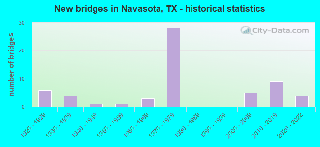
- New bridges - historical statistics
- 61920-1929
- 41930-1939
- 11940-1949
- 11950-1959
- 31960-1969
- 281970-1979
- 52000-2009
- 92010-2019
- 42020-2022
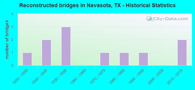
- Reconstructed bridges - Historical Statistics
- 11930-1939
- 21940-1949
- 31950-1959
- 01960-1969
- 11970-1979
- 11980-1989
- 11990-1999
- 02000-2009
- 22010-2019
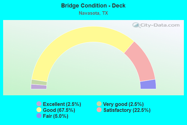
- Bridge Condition - Deck
- 2.5%Excellent
- 2.5%Very good
- 67.5%Good
- 22.5%Satisfactory
- 5.0%Fair
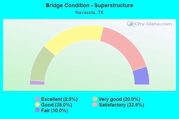
- Bridge Condition - Superstructure
- 2.5%Excellent
- 20.0%Very good
- 35.0%Good
- 32.5%Satisfactory
- 10.0%Fair
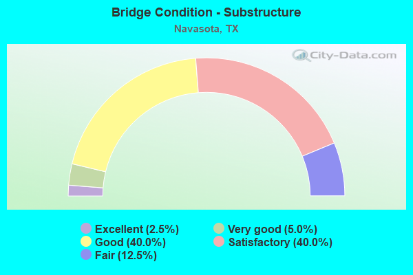
- Bridge Condition - Substructure
- 2.5%Excellent
- 5.0%Very good
- 40.0%Good
- 40.0%Satisfactory
- 12.5%Fair
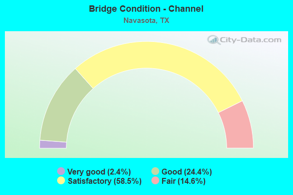
- Bridge Condition - Channel
- 2.4%Very good
- 24.4%Good
- 58.5%Satisfactory
- 14.6%Fair
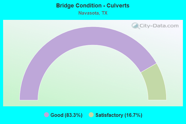
- Bridge Condition - Culverts
- 83.3%Good
- 16.7%Satisfactory
Find on map >> Show street view
Structure Number: 170940B00440001, Location: 0.8 MI NW OF SH 105 (Lat: 30.400903, Lng: -96.084714), Route carried "on" structure: City street , Year Built: 1979, Status: Open, Structure Length: 1.07m (3.51ft), Average Daily Traffic: 850 (year 2016), Average Future Daily Traffic: 900 (year 2038), Features Intersected: CEDAR CREEK, Facility Carried by Structure: VICTORIA AVE
Minimum Vertical Clearance: 30+ m (98+ ft), Kilometerpoint: 0.354, Lanes on structure: 2, Owner: City or Municipal Highway Agency, Approaching Roadway Width: 12.1m (39.7ft), Skew: 2 degrees, Material/Design: Concrete, Design/Construction: Culvert, Number Of Spans In Main Unit: 3, Length of Maximum Span: 3.0m (9.8ft), Curb or Sidewalk Widths: Left: 1.6m (5.2ft), Right: 1.1m (3.6ft), Curb-To-Curb Width: 12.1m (39.7ft), Out-to-Out Width: 15.3m (50.2ft)
Condition: Channel: Satisfactory, Culverts: Satisfactory, Operating Rating: 32.7 metric tons, Method Used To Determine Operating Rating: Field evaluation and documented engineering judgment, Inventory Rating: 24.5 metric tons, Method Used To Determine Inventory Rating: Field evaluation and documented engineering judgment, Structural Evaluation: Equal to present minimum criteria, Deck Geometry: Better than present minimum criteria, Waterway Adequacy: Equal to present minimum criteria, Approach Roadway Alignment: Equal to present desirable criteria, Designated Inspection Frequency: Every 24 months, Inspection Date: December 2021, Deck Structure Type: Concrete Cast-file-Place, Wearing Surface/Protective System: Wearing Surface: Monolithic Concrete
Find on map >> Show street view
Structure Number: 170940B00450001, Location: 0.3 MI NW OF SH 105 (Lat: 30.394150, Lng: -96.085719), Route carried "on" structure: City street , Year Built: 1950, Status: Posted for load, Structure Length: 2.23m (7.32ft), Average Daily Traffic: 2,000 (year 2016), Average Future Daily Traffic: 2,100 (year 2038), Features Intersected: CEDAR CREEK, Facility Carried by Structure: BROSIG AVE
Minimum Vertical Clearance: 30+ m (98+ ft), Kilometerpoint: 2.517, Lanes on structure: 2, Owner: City or Municipal Highway Agency, Approaching Roadway Width: 10.4m (34.1ft), Material/Design: Concrete, Design/Construction: Tee Beam, Number Of Spans In Main Unit: 2, Number Of Approach Spans: 1, Length of Maximum Span: 7.9m (25.9ft), Curb-To-Curb Width: 7.8m (25.6ft), Out-to-Out Width: 8.5m (27.9ft)
Condition: Deck: Satisfactory, Superstructure: Fair, Substructure: Satisfactory, Channel: Satisfactory, Operating Rating: 32.7 metric tons, Method Used To Determine Operating Rating: Field evaluation and documented engineering judgment, Inventory Rating: 24.5 metric tons, Method Used To Determine Inventory Rating: Field evaluation and documented engineering judgment, Structural Evaluation: Somewhat better than minimum adequacy, Deck Geometry: Meets minimum limits, Waterway Adequacy: Equal to present minimum criteria, Approach Roadway Alignment: Equal to present desirable criteria, Bridge Posting: Required (Relationship of Operating Rating to Maximum Legal Load: 20.0 - 29.9% below), Length Of Structure Improvement: 3.02m (9.91ft), Designated Inspection Frequency: Every 24 months, Inspection Date: December 2021, Bridge Improvement Cost: $160,000, Roadway Improvement Cost: $16,000, Total Project Cost: $239,000, Deck Structure Type: Concrete Cast-file-Place, Wearing Surface/Protective System: Wearing Surface: Bituminous
Find on map >> Show street view
Structure Number: 170940B00460001, Location: 0.2 MI NW OF SH 105 (Lat: 30.390750, Lng: -96.088278), Route carried "on" structure: City street , Year Built: 1938, Status: Posted for load, Structure Length: 1.92m (6.30ft), Average Daily Traffic: 520 (year 2016), Average Future Daily Traffic: 550 (year 2038), Features Intersected: CEDAR CREEK, Facility Carried by Structure: OLD MILLICAN RD
Minimum Vertical Clearance: 30+ m (98+ ft), Kilometerpoint: 1.120, Lanes on structure: 2, Owner: City or Municipal Highway Agency, Approaching Roadway Width: 6.7m (22.0ft), Skew: 2 degrees, Material/Design: Steel, Design/Construction: Stringer/Multi-beam, Number Of Spans In Main Unit: 2, Length of Maximum Span: 9.8m (32.2ft), Curb-To-Curb Width: 7.2m (23.6ft), Out-to-Out Width: 9.0m (29.5ft)
Condition: Deck: Satisfactory, Superstructure: Satisfactory, Substructure: Satisfactory, Channel: Satisfactory, Operating Rating: 14.5 metric tons, Method Used To Determine Operating Rating: Allowable Stress (AS), Inventory Rating: 7.3 metric tons, Method Used To Determine Inventory Rating: Allowable Stress (AS), Structural Evaluation: High priority of replacement, Deck Geometry: Meets minimum limits, Waterway Adequacy: Better than present minimum criteria, Approach Roadway Alignment: Equal to present desirable criteria, Bridge Posting: Required (Relationship of Operating Rating to Maximum Legal Load: > 39.9% below), Length Of Structure Improvement: 2.68m (8.79ft), Designated Inspection Frequency: Every 24 months, Inspection Date: December 2021, Bridge Improvement Cost: $7,000, Roadway Improvement Cost: $2,000, Total Project Cost: $9,000, Deck Structure Type: Concrete Cast-file-Place, Wearing Surface/Protective System: Wearing Surface: Bituminous
Find on map >> Show street view
Structure Number: 170940B00475001, Location: 0.1 MI NE OF SH 105 (Lat: 30.388728, Lng: -96.089856), Route carried "on" structure: City street , Year Built: 1938, Status: Open, Structure Length: 1.86m (6.10ft), Average Daily Traffic: 540 (year 2016), Average Future Daily Traffic: 600 (year 2038), Features Intersected: CEDAR CREEK, Facility Carried by Structure: DUKE ST
Minimum Vertical Clearance: 30+ m (98+ ft), Kilometerpoint: 0.864, Lanes on structure: 2, Owner: City or Municipal Highway Agency, Approaching Roadway Width: 7.9m (25.9ft), Skew: 2 degrees, Material/Design: Concrete continuous, Design/Construction: Tee Beam, Number Of Spans In Main Unit: 4, Length of Maximum Span: 4.9m (16.1ft), Curb-To-Curb Width: 8.3m (27.2ft), Out-to-Out Width: 9.1m (29.9ft)
Condition: Deck: Satisfactory, Superstructure: Satisfactory, Substructure: Satisfactory, Channel: Satisfactory, Operating Rating: 32.7 metric tons, Method Used To Determine Operating Rating: Field evaluation and documented engineering judgment, Inventory Rating: 24.5 metric tons, Method Used To Determine Inventory Rating: Field evaluation and documented engineering judgment, Structural Evaluation: Equal to present minimum criteria, Deck Geometry: Somewhat better than minimum adequacy, Waterway Adequacy: Better than present minimum criteria, Approach Roadway Alignment: Equal to present desirable criteria, Length Of Structure Improvement: 1.86m (6.10ft), Designated Inspection Frequency: Every 24 months, Inspection Date: December 2021, Bridge Improvement Cost: $136,000, Roadway Improvement Cost: $14,000, Total Project Cost: $204,000, Deck Structure Type: Concrete Cast-file-Place, Wearing Surface/Protective System: Wearing Surface: Bituminous
Find on map >> Show street view
Structure Number: 170940B00480001, Location: 0.1 MI NW OF SH 105 (Lat: 30.387936, Lng: -96.091633), Route carried "on" structure: City street , Year Built: 1940, Status: Open, Structure Length: 1.89m (6.20ft), Average Daily Traffic: 540 (year 2016), Average Future Daily Traffic: 600 (year 2038), Features Intersected: CEDAR CREEK, Facility Carried by Structure: 10TH ST
Minimum Vertical Clearance: 30+ m (98+ ft), Kilometerpoint: 0.476, Lanes on structure: 2, Owner: City or Municipal Highway Agency, Approaching Roadway Width: 6.7m (22.0ft), Material/Design: Concrete, Design/Construction: Tee Beam, Number Of Spans In Main Unit: 2, Length of Maximum Span: 9.4m (30.8ft), Curb or Sidewalk Widths: Left: 1.4m (4.6ft), Right: 1.4m (4.6ft), Curb-To-Curb Width: 5.8m (19.0ft), Out-to-Out Width: 9.2m (30.2ft)
Condition: Deck: Satisfactory, Superstructure: Satisfactory, Substructure: Satisfactory, Channel: Good, Operating Rating: 32.7 metric tons, Method Used To Determine Operating Rating: Field evaluation and documented engineering judgment, Inventory Rating: 24.5 metric tons, Method Used To Determine Inventory Rating: Field evaluation and documented engineering judgment, Structural Evaluation: Equal to present minimum criteria, Deck Geometry: High priority of replacement, Waterway Adequacy: Better than present minimum criteria, Approach Roadway Alignment: Equal to present desirable criteria, Length Of Structure Improvement: 1.89m (6.20ft), Designated Inspection Frequency: Every 24 months, Inspection Date: December 2021, Bridge Improvement Cost: $2,000, Roadway Improvement Cost: $1,000, Total Project Cost: $3,000, Deck Structure Type: Concrete Cast-file-Place, Wearing Surface/Protective System: Wearing Surface: Bituminous
Find on map >> Show street view
Structure Number: 170940B00490001, Location: 0.1 MI NW OF SH 105 (Lat: 30.387317, Lng: -96.098186), Route carried "on" structure: City street , Year Built: 1979, Status: Open, Structure Length: 3.66m (12.01ft), Average Daily Traffic: 1,750 (year 2016), Average Future Daily Traffic: 1,800 (year 2038), Features Intersected: CEDAR CREEK, Facility Carried by Structure: 5TH ST
Minimum Vertical Clearance: 30+ m (98+ ft), Kilometerpoint: 0.404, Lanes on structure: 2, Owner: City or Municipal Highway Agency, Approaching Roadway Width: 9.8m (32.2ft), Material/Design: Concrete, Design/Construction: Stringer/Multi-beam, Number Of Spans In Main Unit: 3, Length of Maximum Span: 12.2m (40.0ft), Curb-To-Curb Width: 10.5m (34.4ft), Out-to-Out Width: 11.0m (36.1ft)
Condition: Deck: Good, Superstructure: Good, Substructure: Good, Channel: Satisfactory, Operating Rating: 32.7 metric tons, Method Used To Determine Operating Rating: Field evaluation and documented engineering judgment, Inventory Rating: 24.5 metric tons, Method Used To Determine Inventory Rating: Field evaluation and documented engineering judgment, Structural Evaluation: Equal to present minimum criteria, Deck Geometry: Equal to present minimum criteria, Waterway Adequacy: Better than present minimum criteria, Approach Roadway Alignment: Somewhat better than minimum adequacy, Designated Inspection Frequency: Every 24 months, Inspection Date: December 2021, Deck Structure Type: Concrete Cast-file-Place
Find on map >> Show street view
Structure Number: 172390031506082, Location: 0.59 MI E OF FM 1155 (Lat: 30.348358, Lng: -96.165511), Route carried "on" structure: State highway 105, Year Built: 2021, Status: Open, Structure Length: 15.85m (52.00ft), Average Daily Traffic: 5,800 (year 2010), Average Future Daily Traffic: 9,550 (year 2040), Design Load: HL 93, Features Intersected: COLES CREEK
Minimum Vertical Clearance: 30+ m (98+ ft), Kilometerpoint: 31.028, Lanes on structure: 2, Owner: State Highway Agency, Approaching Roadway Width: 13.4m (44.0ft), Material/Design: Prestressed concrete, Design/Construction: Stringer/Multi-beam, Number Of Spans In Main Unit: 4, Length of Maximum Span: 39.6m (129.9ft), Curb-To-Curb Width: 13.3m (43.6ft), Out-to-Out Width: 14.0m (45.9ft)
Condition: Deck: Good, Superstructure: Good, Substructure: Good, Channel: Good, Operating Rating: 54.4 metric tons, Method Used To Determine Operating Rating: Assigned ratings based on Load and Resistance Factor Design (LRFD) reported in metric tons, Inventory Rating: 32.7 metric tons, Method Used To Determine Inventory Rating: Assigned ratings based on Load and Resistance Factor Design (LRFD) reported in metric tons, Structural Evaluation: Better than present minimum criteria, Deck Geometry: Somewhat better than minimum adequacy, Waterway Adequacy: Superior to present desirable criteria, Approach Roadway Alignment: Equal to present desirable criteria, Designated Inspection Frequency: Every 24 months, Inspection Date: November 2021, Deck Structure Type: Concrete Cast-file-Place
Find on map >> Show street view
Structure Number: 172390031512034, Location: 1.06 MI SE OF SH 105 (Lat: 30.327686, Lng: -96.161536), Route carried "on" structure: State highway 1155, Year Built: 1925, Year Reconstructed: 1959, Status: Open, Structure Length: 0.64m (2.10ft), Average Daily Traffic: 663 (year 2020), Truck Traffic: 6%, Average Future Daily Traffic: 920 (year 2033), Design Load: H 15, Features Intersected: DRAW
Minimum Vertical Clearance: 30+ m (98+ ft), Kilometerpoint: 8.145, Lanes on structure: 2, Owner: State Highway Agency, Approaching Roadway Width: 8.5m (27.9ft), Material/Design: Concrete, Design/Construction: Culvert, Number Of Spans In Main Unit: 2, Length of Maximum Span: 3.0m (9.8ft), Curb-To-Curb Width: 10.4m (34.1ft), Out-to-Out Width: 10.8m (35.4ft)
Condition: Channel: Good, Culverts: Good, Operating Rating: 39.9 metric tons, Method Used To Determine Operating Rating: Load Factor (LF), Inventory Rating: 23.6 metric tons, Method Used To Determine Inventory Rating: Load Factor (LF), Structural Evaluation: Equal to present minimum criteria, Deck Geometry: Equal to present minimum criteria, Waterway Adequacy: Equal to present minimum criteria, Approach Roadway Alignment: Equal to present desirable criteria, Designated Inspection Frequency: Every 24 months, Inspection Date: April 2021, Deck Structure Type: Concrete Cast-file-Place, Wearing Surface/Protective System: Wearing Surface: Bituminous
Find on map >> Show street view
Structure Number: 172390031512078, Location: 0.15 MI SE OF SH 105 (Lat: 30.334753, Lng: -96.163050), Route carried "on" structure: State highway 1155, Year Built: 2009, Status: Open, Structure Length: 3.20m (10.50ft), Average Daily Traffic: 700 (year 2020), Truck Traffic: 15%, Average Future Daily Traffic: 1,500 (year 2029), Design Load: HL 93, Features Intersected: JORDAN CREEK
Minimum Vertical Clearance: 30+ m (98+ ft), Kilometerpoint: 7.393, Lanes on structure: 2, Owner: State Highway Agency, Approaching Roadway Width: 8.5m (27.9ft), Material/Design: Prestressed concrete, Design/Construction: Stringer/Multi-beam, Number Of Spans In Main Unit: 1, Length of Maximum Span: 32.0m (105.0ft), Curb-To-Curb Width: 8.9m (29.2ft), Out-to-Out Width: 9.8m (32.2ft)
Condition: Deck: Very good, Superstructure: Good, Substructure: Good, Channel: Fair, Operating Rating: 54.4 metric tons, Method Used To Determine Operating Rating: Assigned ratings based on Load and Resistance Factor Design (LRFD) reported in metric tons, Inventory Rating: 32.7 metric tons, Method Used To Determine Inventory Rating: Assigned ratings based on Load and Resistance Factor Design (LRFD) reported in metric tons, Structural Evaluation: Better than present minimum criteria, Deck Geometry: Somewhat better than minimum adequacy, Waterway Adequacy: Superior to present desirable criteria, Approach Roadway Alignment: Equal to present desirable criteria, Designated Inspection Frequency: Every 24 months, Inspection Date: April 2021, Deck Structure Type: Concrete Precast Panels, Wearing Surface/Protective System: Wearing Surface: Monolithic Concrete
Find on map >> Show street view
Structure Number: 170210005002165, Location: 6.1 MI S OF FM 159 (Lat: 30.440594, Lng: -96.126978), Route carried "under" structure: State highway 2154, Year Built: 2010, Structure Length: 0. m, Average Daily Traffic: 1,850 (year 2017), Truck Traffic: 25%, Features Intersected: FM 2154, Facility Carried by Structure: SH 6 NB
Minimum Vertical Clearance: 7.44m (24.41ft), Kilometerpoint: 35.388, Lanes on structure: 2, Lanes under structure: 2, Material/Design: Prestressed concrete, Design/Construction: Stringer/Multi-beam, Length of Maximum Span: 27.4m (89.9ft)
Find on map >> Show street view
Structure Number: 170210005002166, Location: 6.1 MI S OF FM 159 (Lat: 30.440972, Lng: -96.127953), Route carried "under" structure: State highway 2154, Year Built: 2010, Structure Length: 0. m, Average Daily Traffic: 1,850 (year 2017), Truck Traffic: 25%, Features Intersected: FM 2154, Facility Carried by Structure: SH 6 SB
Minimum Vertical Clearance: 7.01m (23.00ft), Kilometerpoint: 35.388, Lanes on structure: 2, Lanes under structure: 2, Material/Design: Prestressed concrete, Design/Construction: Stringer/Multi-beam, Length of Maximum Span: 27.4m (89.9ft)
Find on map >> Show street view
Structure Number: 170940005003054, Location: 1.1 MI NW OF FM 3090 (Lat: 30.413714, Lng: -96.101686), Route carried "under" structure: State highway 6, Year Built: 1971, Structure Length: 0. m, Average Daily Traffic: 33,386 (year 2019), Truck Traffic: 17%, Features Intersected: SH 6 NB BUS
Minimum Vertical Clearance: 5.33m (17.49ft), Kilometerpoint: 0.660, Lanes on structure: 2, Lanes under structure: 2, Material/Design: Steel continuous, Design/Construction: Stringer/Multi-beam, Length of Maximum Span: 41.1m (134.8ft)
Find on map >> Show street view
Structure Number: 170940005003055, Location: 1.05 MI NW OF SH 90 (Lat: 30.408031, Lng: -96.084244), Route carried "under" structure: State highway 6, Year Built: 1971, Structure Length: 0. m, Average Daily Traffic: 46,740 (year 2019), Truck Traffic: 17%, Features Intersected: SH 06, Facility Carried by Structure: FM 3090
Minimum Vertical Clearance: 5.03m (16.50ft), Kilometerpoint: 2.406, Lanes on structure: 2, Lanes under structure: 4, Material/Design: Prestressed concrete, Design/Construction: Stringer/Multi-beam, Length of Maximum Span: 30.5m (100.1ft)
Find on map >> Show street view
Structure Number: 170940005003062, Location: 3.9 MI S OF SH 90 (Lat: 30.343556, Lng: -96.051664), Route carried "under" structure: Business State highway 6, Year Built: 1971, Structure Length: 0. m, Average Daily Traffic: 2,434 (year 2019), Truck Traffic: 5%, Features Intersected: SH 6 SB
Minimum Vertical Clearance: 5.41m (17.75ft), Kilometerpoint: 42.392, Lanes on structure: 2, Lanes under structure: 2, Material/Design: Steel continuous, Design/Construction: Stringer/Multi-beam, Length of Maximum Span: 41.1m (134.8ft)
Find on map >> Show street view
Structure Number: 170940005003074, Location: 1.1 MI S OF FM 3090 (Lat: 30.396694, Lng: -96.071756), Route carried "under" structure: State highway 90, Year Built: 1971, Structure Length: 0. m, Average Daily Traffic: 12,388 (year 2019), Truck Traffic: 6%, Features Intersected: SH 6, Facility Carried by Structure: SH 6 SB
Minimum Vertical Clearance: 4.75m (15.58ft), Kilometerpoint: 55.891, Lanes on structure: 2, Lanes under structure: 5, Material/Design: Prestressed concrete, Design/Construction: Stringer/Multi-beam, Length of Maximum Span: 30.5m (100.1ft)
Find on map >> Show street view
Structure Number: 170940005003075, Location: 1.1 MI S OF FM 3090 (Lat: 30.396678, Lng: -96.071758), Route carried "under" structure: State highway 90, Year Built: 1971, Structure Length: 0. m, Average Daily Traffic: 12,388 (year 2013), Truck Traffic: 6%, Features Intersected: SH 6 NB, Facility Carried by Structure: SH 6 NB
Minimum Vertical Clearance: 4.80m (15.75ft), Kilometerpoint: 55.859, Lanes on structure: 2, Lanes under structure: 5, Material/Design: Prestressed concrete, Design/Construction: Stringer/Multi-beam, Length of Maximum Span: 30.5m (100.1ft)
Find on map >> Show street view
Structure Number: 170940005003103, Location: 1.45 MI S OF SH 90 (Lat: 30.376161, Lng: -96.067669), Route carried "under" structure: State highway 105, Year Built: 1971, Structure Length: 0. m, Average Daily Traffic: 10,847 (year 2019), Truck Traffic: 9%, Features Intersected: SH 6 SB, Facility Carried by Structure: SH 6 SB
Minimum Vertical Clearance: 5.11m (16.77ft), Kilometerpoint: 1.366, Lanes on structure: 5, Material/Design: Prestressed concrete, Design/Construction: Stringer/Multi-beam, Length of Maximum Span: 30.5m (100.1ft)
Find on map >> Show street view
Structure Number: 170940005003104, Location: 1.45 MI S OF SH 90 (Lat: 30.376339, Lng: -96.066719), Route carried "under" structure: State highway 105, Year Built: 1971, Structure Length: 0. m, Average Daily Traffic: 10,847 (year 2019), Truck Traffic: 9%, Features Intersected: SH 6 NB, Facility Carried by Structure: SH 6 NB
Minimum Vertical Clearance: 4.75m (15.58ft), Kilometerpoint: 1.429, Lanes on structure: 5, Material/Design: Prestressed concrete, Design/Construction: Stringer/Multi-beam, Length of Maximum Span: 30.5m (100.1ft)