Bridge Statistics for Owasso, Oklahoma (OK)
Condition, Traffic, Stress, Structural Evaluation, Project Costs
- New bridges - historical statistics
- 51940-1949
- 11950-1959
- 81960-1969
- 71970-1979
- 221980-1989
- 61990-1999
- 62000-2009
- 72010-2019
- 32020-2022
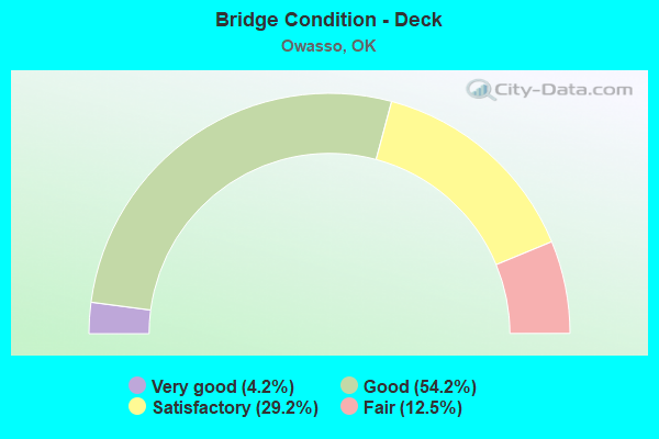
- Bridge Condition - Deck
- 4.2%Very good
- 54.2%Good
- 29.2%Satisfactory
- 12.5%Fair
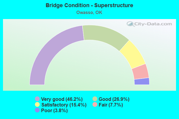
- Bridge Condition - Superstructure
- 46.2%Very good
- 26.9%Good
- 15.4%Satisfactory
- 7.7%Fair
- 3.8%Poor
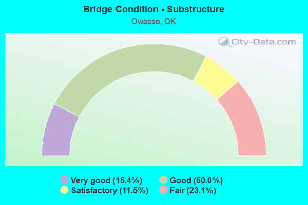
- Bridge Condition - Substructure
- 15.4%Very good
- 50.0%Good
- 11.5%Satisfactory
- 23.1%Fair
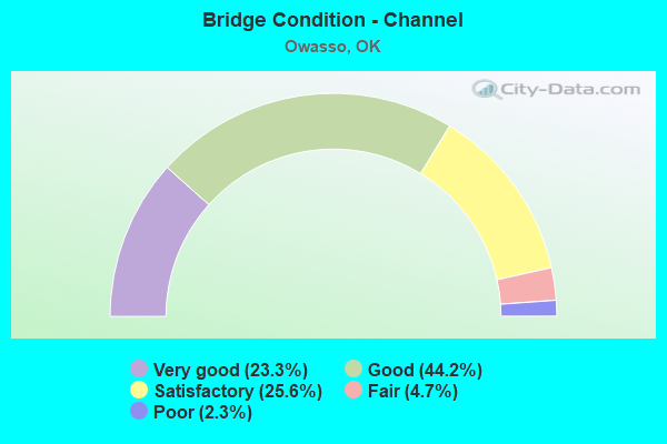
- Bridge Condition - Channel
- 23.3%Very good
- 44.2%Good
- 25.6%Satisfactory
- 4.7%Fair
- 2.3%Poor
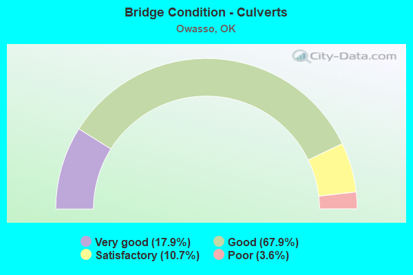
- Bridge Condition - Culverts
- 17.9%Very good
- 67.9%Good
- 10.7%Satisfactory
- 3.6%Poor
Find on map >> Show street view
Structure Number: 28138, Location: .5E. OF MEMORIAL (Lat: 36.264183, Lng: -95.875028), Route carried "on" structure: County highway E0520, Year Built: 2004, Status: Open, Structure Length: 1.34m (4.40ft), Average Daily Traffic: 3,165 (year 2020), Truck Traffic: 5%, Average Future Daily Traffic: 5,064 (year 2040), Design Load: HS 20, Features Intersected: RANCH CREEK O'FLOW
Minimum Vertical Clearance: 30+ m (98+ ft), Kilometerpoint: 0.805, Lanes on structure: 4, Owner: County Highway Agency, Approaching Roadway Width: 15.8m (51.8ft), Material/Design: Concrete, Design/Construction: Culvert, Number Of Spans In Main Unit: 3, Length of Maximum Span: 4.3m (14.1ft), Curb-To-Curb Width: 28.0m (91.9ft), Out-to-Out Width: 28.7m (94.2ft)
Condition: Channel: Very good, Culverts: Good, Operating Rating: 42.6 metric tons, Method Used To Determine Operating Rating: Load Factor (LF), Inventory Rating: 32.7 metric tons, Method Used To Determine Inventory Rating: Load Factor (LF), Structural Evaluation: Better than present minimum criteria, Deck Geometry: Superior to present desirable criteria, Waterway Adequacy: Equal to present minimum criteria, Approach Roadway Alignment: Equal to present desirable criteria, Length Of Structure Improvement: 1.39m (4.56ft), Designated Inspection Frequency: Every 24 months, Inspection Date: November 2021, Bridge Improvement Cost: $400,000, Roadway Improvement Cost: $600,000, Total Project Cost: $1,150,000 ( Estimate for 2015)
Find on map >> Show street view
Structure Number: 28139, Location: .1 E OF MINGO ROAD (Lat: 36.264175, Lng: -95.863992), Route carried "on" structure: County highway E0520, Year Built: 2004, Status: Open, Structure Length: 1.34m (4.40ft), Average Daily Traffic: 3,165 (year 2020), Truck Traffic: 5%, Average Future Daily Traffic: 5,064 (year 2040), Design Load: HS 20, Features Intersected: RANCH CREEK O'FLOW
Minimum Vertical Clearance: 30+ m (98+ ft), Kilometerpoint: 0.161, Lanes on structure: 4, Owner: County Highway Agency, Approaching Roadway Width: 15.8m (51.8ft), Material/Design: Concrete, Design/Construction: Culvert, Number Of Spans In Main Unit: 3, Length of Maximum Span: 4.3m (14.1ft), Curb-To-Curb Width: 28.0m (91.9ft), Out-to-Out Width: 28.7m (94.2ft)
Condition: Channel: Good, Culverts: Good, Operating Rating: 42.6 metric tons, Method Used To Determine Operating Rating: Load Factor (LF), Inventory Rating: 32.7 metric tons, Method Used To Determine Inventory Rating: Load Factor (LF), Structural Evaluation: Better than present minimum criteria, Deck Geometry: Superior to present desirable criteria, Waterway Adequacy: Equal to present minimum criteria, Approach Roadway Alignment: Equal to present desirable criteria, Length Of Structure Improvement: 1.39m (4.56ft), Designated Inspection Frequency: Every 24 months, Inspection Date: November 2021, Bridge Improvement Cost: $400,000, Roadway Improvement Cost: $600,000, Total Project Cost: $1,150,000 ( Estimate for 2015)
Find on map >> Show street view
Structure Number: 29439, Location: 2.4S OF S.H. 20 (Lat: 36.287500, Lng: -95.794444), Route carried "on" structure: County highway N4050, Year Built: 2011, Status: Open, Structure Length: 3.66m (12.01ft), Average Daily Traffic: 1,477 (year 2020), Truck Traffic: 10%, Average Future Daily Traffic: 2,363 (year 2040), Design Load: HS 20, Features Intersected: ELM CREEK
Minimum Vertical Clearance: 30+ m (98+ ft), Kilometerpoint: 0.644, Lanes on structure: 3, Owner: County Highway Agency, Approaching Roadway Width: 17.7m (58.1ft), Material/Design: Prestressed concrete, Design/Construction: Slab, Number Of Spans In Main Unit: 3, Length of Maximum Span: 12.2m (40.0ft), Curb-To-Curb Width: 16.5m (54.1ft), Out-to-Out Width: 17.2m (56.4ft)
Condition: Deck: Very good, Superstructure: Very good, Substructure: Good, Channel: Good, Operating Rating: 66.6 metric tons, Method Used To Determine Operating Rating: Load Factor (LF), Inventory Rating: 36.0 metric tons, Method Used To Determine Inventory Rating: Load Factor (LF), Structural Evaluation: Better than present minimum criteria, Deck Geometry: Better than present minimum criteria, Waterway Adequacy: Equal to present desirable criteria, Approach Roadway Alignment: Equal to present desirable criteria, Designated Inspection Frequency: Every 24 months, Inspection Date: July 2021, Deck Structure Type: Concrete Cast-file-Place, Wearing Surface/Protective System: Wearing Surface: Bituminous
Find on map >> Show street view
Structure Number: 30247, Location: 86 ST. N .8E OF MEMORIAL (Lat: 36.278611, Lng: -95.870833), Route carried "on" structure: County highway 7210C, Year Built: 2012, Status: Open, Structure Length: 6.86m (22.51ft), Average Daily Traffic: 3,810 (year 2020), Truck Traffic: 5%, Average Future Daily Traffic: 6,096 (year 2040), Design Load: HS 20, Features Intersected: RANCH CREEK
Minimum Vertical Clearance: 30+ m (98+ ft), Kilometerpoint: 1.287, Lanes on structure: 4, Owner: County Highway Agency, Approaching Roadway Width: 15.8m (51.8ft), Material/Design: Prestressed concrete, Design/Construction: Stringer/Multi-beam, Number Of Spans In Main Unit: 3, Length of Maximum Span: 22.9m (75.1ft), Curb or Sidewalk Widths: Left: 1.5m (4.9ft), Right: 1.5m (4.9ft), Curb-To-Curb Width: 15.8m (51.8ft), Out-to-Out Width: 20.1m (65.9ft)
Condition: Deck: Good, Superstructure: Very good, Substructure: Good, Channel: Very good, Operating Rating: 44.5 metric tons, Method Used To Determine Operating Rating: Load Factor (LF), Inventory Rating: 32.7 metric tons, Method Used To Determine Inventory Rating: Load Factor (LF), Structural Evaluation: Better than present minimum criteria, Deck Geometry: Meets minimum limits, Waterway Adequacy: Equal to present desirable criteria, Approach Roadway Alignment: Equal to present desirable criteria, Designated Inspection Frequency: Every 24 months, Inspection Date: August 2021, Deck Structure Type: Concrete Cast-file-Place, Wearing Surface/Protective System: Wearing Surface: Monolithic Concrete, Deck Protection: Epoxy Coated Reinforcing
Find on map >> Show street view
Structure Number: 30248, Location: 86 ST. N .3E OF MINGO RD (Lat: 36.278611, Lng: -95.861944), Route carried "on" structure: County highway 7210C, Year Built: 2012, Status: Open, Structure Length: 1.68m (5.51ft), Average Daily Traffic: 3,810 (year 2020), Truck Traffic: 5%, Average Future Daily Traffic: 6,000 (year 2040), Features Intersected: CREEK
Minimum Vertical Clearance: 30+ m (98+ ft), Kilometerpoint: 0.777, Lanes on structure: 4, Owner: County Highway Agency, Approaching Roadway Width: 16.8m (55.1ft), Material/Design: Concrete, Design/Construction: Culvert, Number Of Spans In Main Unit: 4, Length of Maximum Span: 4.0m (13.1ft), Curb or Sidewalk Widths: Left: 1.8m (5.9ft), Right: 1.8m (5.9ft), Curb-To-Curb Width: 16.8m (55.1ft), Out-to-Out Width: 20.4m (66.9ft)
Condition: Channel: Satisfactory, Culverts: Good, Operating Rating: 65.5 metric tons, Method Used To Determine Operating Rating: Load Factor (LF), Inventory Rating: 39.3 metric tons, Method Used To Determine Inventory Rating: Load Factor (LF), Structural Evaluation: Better than present minimum criteria, Deck Geometry: Somewhat better than minimum adequacy, Waterway Adequacy: Equal to present desirable criteria, Approach Roadway Alignment: Equal to present desirable criteria, Designated Inspection Frequency: Every 24 months, Inspection Date: July 2021, Total Project Cost: $225,000
Find on map >> Show street view
Structure Number: 30302, Location: .1E OF 145TH (Lat: 36.311944, Lng: -95.809444), Route carried "on" structure: City street E0487, Year Built: 2010, Status: Open, Structure Length: 0.82m (2.69ft), Average Daily Traffic: 200 (year 2020), Truck Traffic: 5%, Average Future Daily Traffic: 160 (year 2040), Design Load: HS 20, Features Intersected: ELM CREEK TRIB.
Minimum Vertical Clearance: 30+ m (98+ ft), Kilometerpoint: 0.161, Lanes on structure: 2, Owner: City or Municipal Highway Agency, Approaching Roadway Width: 7.9m (25.9ft), Material/Design: Steel, Design/Construction: Arch - Thru, Number Of Spans In Main Unit: 2, Length of Maximum Span: 3.7m (12.1ft), Curb-To-Curb Width: 7.9m (25.9ft), Out-to-Out Width: 16.5m (54.1ft)
Condition: Superstructure: Very good, Substructure: Very good, Channel: Very good, Inventory Rating: 78.4 metric tons, Method Used To Determine Inventory Rating: Load Factor (LF), Structural Evaluation: Equal to present desirable criteria, Deck Geometry: Somewhat better than minimum adequacy, Waterway Adequacy: Equal to present minimum criteria, Approach Roadway Alignment: Equal to present desirable criteria, Designated Inspection Frequency: Every 24 months, Inspection Date: July 2021, Total Project Cost: $225,000
Find on map >> Show street view
Structure Number: 30303, Location: .4E OF 129TH (Lat: 36.278333, Lng: -95.821667), Route carried "on" structure: City street E0510, Year Built: 2004, Status: Open, Structure Length: 0.85m (2.79ft), Average Daily Traffic: 19,093 (year 2020), Truck Traffic: 5%, Average Future Daily Traffic: 160 (year 2040), Design Load: HS 20, Features Intersected: ELM CREEK TRIB.
Minimum Vertical Clearance: 30+ m (98+ ft), Kilometerpoint: 0.644, Lanes on structure: 5, Owner: City or Municipal Highway Agency, Approaching Roadway Width: 19.5m (64.0ft), Material/Design: Concrete, Design/Construction: Culvert, Number Of Spans In Main Unit: 7, Length of Maximum Span: 1.2m (3.9ft), Curb or Sidewalk Widths: Left: 1.8m (5.9ft), Right: 1.8m (5.9ft)
Condition: Channel: Satisfactory, Culverts: Very good, Operating Rating: 39.7 metric tons, Method Used To Determine Operating Rating: Load Factor (LF), Inventory Rating: 23.8 metric tons, Method Used To Determine Inventory Rating: Load Factor (LF), Structural Evaluation: Somewhat better than minimum adequacy, Waterway Adequacy: Better than present minimum criteria, Approach Roadway Alignment: Equal to present desirable criteria, Length Of Structure Improvement: 0.70m (2.30ft), Designated Inspection Frequency: Every 24 months, Inspection Date: July 2021, Bridge Improvement Cost: $100,000, Roadway Improvement Cost: $75,000, Total Project Cost: $225,000 ( Estimate for 2015)
Find on map >> Show street view
Structure Number: 30304, Location: .1N OF 106TH ST. (Lat: 36.310278, Lng: -95.810278), Route carried "on" structure: City street N4041, Year Built: 2011, Status: Open, Structure Length: 0.64m (2.10ft), Average Daily Traffic: 100 (year 2020), Truck Traffic: 5%, Average Future Daily Traffic: 160 (year 2040), Design Load: HS 20, Features Intersected: ELM CREEK TRIB.
Minimum Vertical Clearance: 30+ m (98+ ft), Kilometerpoint: 1.287, Lanes on structure: 2, Owner: City or Municipal Highway Agency, Approaching Roadway Width: 8.2m (26.9ft), Skew: 3 degrees, Material/Design: Steel, Design/Construction: Arch - Thru, Number Of Spans In Main Unit: 2, Length of Maximum Span: 2.7m (8.9ft), Curb-To-Curb Width: 8.2m (26.9ft), Out-to-Out Width: 18.9m (62.0ft)
Condition: Superstructure: Very good, Substructure: Very good, Channel: Good, Structural Evaluation: Equal to present desirable criteria, Deck Geometry: Equal to present minimum criteria, Waterway Adequacy: Better than present minimum criteria, Approach Roadway Alignment: Equal to present desirable criteria, Designated Inspection Frequency: Every 24 months, Inspection Date: July 2021, Total Project Cost: $225,000
Find on map >> Show street view
Structure Number: 30305, Location: .2S OF 96TH (Lat: 36.291389, Lng: -95.848333), Route carried "on" structure: City street N4020, Year Built: 2005, Status: Open, Structure Length: 0.64m (2.10ft), Average Daily Traffic: 1,000 (year 2020), Truck Traffic: 5%, Average Future Daily Traffic: 1,600 (year 2040), Design Load: HS 20, Features Intersected: RANCH CREEK TRIB.
Minimum Vertical Clearance: 30+ m (98+ ft), Kilometerpoint: 0.518, Lanes on structure: 5, Owner: City or Municipal Highway Agency, Approaching Roadway Width: 18.0m (59.1ft), Material/Design: Concrete, Design/Construction: Culvert, Number Of Spans In Main Unit: 3, Length of Maximum Span: 2.4m (7.9ft)
Condition: Channel: Very good, Culverts: Very good, Operating Rating: 54.4 metric tons, Method Used To Determine Operating Rating: Load Factor (LF), Inventory Rating: 32.7 metric tons, Method Used To Determine Inventory Rating: Load Factor (LF), Structural Evaluation: Equal to present desirable criteria, Waterway Adequacy: Better than present minimum criteria, Approach Roadway Alignment: Equal to present desirable criteria, Designated Inspection Frequency: Every 24 months, Inspection Date: July 2021, Total Project Cost: $225,000
Find on map >> Show street view
Structure Number: 30935, Location: .2S OF S.H. 20 (Lat: 36.304167, Lng: -95.686667), Route carried "on" structure: County highway N4110, Year Built: 2013, Status: Open, Structure Length: 1.16m (3.81ft), Average Daily Traffic: 200 (year 2020), Truck Traffic: 10%, Average Future Daily Traffic: 160 (year 2040), Design Load: HS 20, Features Intersected: JONATHON CREEK
Minimum Vertical Clearance: 30+ m (98+ ft), Kilometerpoint: 0.322, Lanes on structure: 2, Owner: County Highway Agency, Approaching Roadway Width: 7.6m (24.9ft), Material/Design: Concrete, Design/Construction: Culvert, Number Of Spans In Main Unit: 3, Length of Maximum Span: 3.7m (12.1ft), Curb-To-Curb Width: 8.0m (26.2ft), Out-to-Out Width: 9.4m (30.8ft)
Condition: Channel: Good, Culverts: Good, Operating Rating: 53.1 metric tons, Method Used To Determine Operating Rating: Load Factor (LF), Inventory Rating: 31.8 metric tons, Method Used To Determine Inventory Rating: Load Factor (LF), Structural Evaluation: Better than present minimum criteria, Deck Geometry: Somewhat better than minimum adequacy, Waterway Adequacy: Equal to present desirable criteria, Approach Roadway Alignment: Equal to present desirable criteria, Designated Inspection Frequency: Every 24 months, Inspection Date: July 2021, Total Project Cost: $225,000, Wearing Surface/Protective System: Wearing Surface: Bituminous
Find on map >> Show street view
Structure Number: 31336, Location: .8N of E 96TH (Lat: 36.304722, Lng: -95.848056), Route carried "on" structure: County highway N4020, Year Built: 2021, Status: Open, Structure Length: 0.98m (3.22ft), Average Daily Traffic: 1,000 (year 2020), Truck Traffic: 7%, Average Future Daily Traffic: 1,600 (year 2040), Design Load: HS 20, Features Intersected: SAWGRASS RANCH CREEK
Minimum Vertical Clearance: 30+ m (98+ ft), Kilometerpoint: 0.518, Lanes on structure: 4, Owner: City or Municipal Highway Agency, Approaching Roadway Width: 9.1m (29.9ft), Material/Design: Concrete, Design/Construction: Culvert, Number Of Spans In Main Unit: 3, Length of Maximum Span: 3.0m (9.8ft), Curb-To-Curb Width: 9.1m (29.9ft), Out-to-Out Width: 48.8m (160.1ft)
Condition: Channel: Satisfactory, Culverts: Very good, Operating Rating: 78.6 metric tons, Method Used To Determine Operating Rating: Load Factor (LF), Inventory Rating: 47.0 metric tons, Method Used To Determine Inventory Rating: Load Factor (LF), Structural Evaluation: Equal to present desirable criteria, Deck Geometry: High priority of replacement, Waterway Adequacy: Better than present minimum criteria, Approach Roadway Alignment: Equal to present desirable criteria, Designated Inspection Frequency: Every 24 months, Inspection Date: October 2021, Deck Structure Type: Concrete Cast-file-Place, Wearing Surface/Protective System: Wearing Surface: Other
Find on map >> Show street view
Structure Number: 31539, Location: .5E of HWY 169 (Lat: 36.263975, Lng: -95.839200), Route carried "on" structure: City street E0520, Year Built: 2021, Status: Open, Structure Length: 1.04m (3.41ft), Average Daily Traffic: 15,200 (year 2020), Truck Traffic: 5%, Average Future Daily Traffic: 24,320 (year 2040), Design Load: HS 20, Features Intersected: ELM CREEK TRIB.
Minimum Vertical Clearance: 30+ m (98+ ft), Kilometerpoint: 1.296, Lanes on structure: 4, Owner: City or Municipal Highway Agency, Approaching Roadway Width: 9.4m (30.8ft), Skew: 20 degrees, Material/Design: Concrete, Design/Construction: Culvert, Number Of Spans In Main Unit: 3, Length of Maximum Span: 3.0m (9.8ft), Curb or Sidewalk Widths: Left: 4.1m (13.5ft), Right: 2.6m (8.5ft), Curb-To-Curb Width: 22.6m (74.1ft), Out-to-Out Width: 30.0m (98.4ft)
Condition: Channel: Very good, Culverts: Very good, Operating Rating: 64.1 metric tons, Method Used To Determine Operating Rating: Load Factor (LF), Inventory Rating: 38.4 metric tons, Method Used To Determine Inventory Rating: Load Factor (LF), Structural Evaluation: Equal to present desirable criteria, Deck Geometry: Superior to present desirable criteria, Waterway Adequacy: Equal to present desirable criteria, Approach Roadway Alignment: Equal to present desirable criteria, Designated Inspection Frequency: Every 24 months, Inspection Date: July 2021
Find on map >> Show street view
Structure Number: 32139, Location: .2E JCT 129 E/116 N (Lat: 36.322064, Lng: -95.826353), Route carried "on" structure: City street E0480, Year Built: 2021, Status: Open, Structure Length: 0.98m (3.22ft), Average Daily Traffic: 11,400 (year 2020), Truck Traffic: 5%, Average Future Daily Traffic: 18,240 (year 2040), Design Load: HS 20, Features Intersected: BLACKJACK TRIB.
Minimum Vertical Clearance: 30+ m (98+ ft), Kilometerpoint: 0.518, Lanes on structure: 4, Owner: City or Municipal Highway Agency, Approaching Roadway Width: 8.8m (28.9ft), Skew: 1 degrees, Material/Design: Concrete, Design/Construction: Culvert, Number Of Spans In Main Unit: 3, Length of Maximum Span: 3.0m (9.8ft), Curb-To-Curb Width: 8.8m (28.9ft), Out-to-Out Width: 34.7m (113.8ft)
Condition: Channel: Good, Culverts: Good, Inventory Rating: 74.1 metric tons, Method Used To Determine Inventory Rating: Load Factor (LF), Structural Evaluation: Better than present minimum criteria, Deck Geometry: High priority of replacement, Waterway Adequacy: Equal to present desirable criteria, Approach Roadway Alignment: Equal to present desirable criteria, Designated Inspection Frequency: Every 24 months, Inspection Date: October 2021, Deck Structure Type: Concrete Cast-file-Place, Wearing Surface/Protective System: Wearing Surface: Other
Find on map >> Show street view
Structure Number: 3259, Location: .3W .4S OF US169/SH20 (Lat: 36.316400, Lng: -95.827136), Route carried "on" structure: City street E0484, Year Built: 2019, Status: Open, Structure Length: 1.19m (3.90ft), Average Daily Traffic: 500 (year 2020), Truck Traffic: 5%, Average Future Daily Traffic: 905 (year 2040), Features Intersected: CREEK
Minimum Vertical Clearance: 30+ m (98+ ft), Kilometerpoint: 0.518, Lanes on structure: 2, Owner: City or Municipal Highway Agency, Approaching Roadway Width: 7.9m (25.9ft), Material/Design: Concrete, Design/Construction: Culvert, Number Of Spans In Main Unit: 5, Length of Maximum Span: 2.1m (6.9ft)
Condition: Channel: Good, Culverts: Good, Operating Rating: 54.4 metric tons, Method Used To Determine Operating Rating: Load Factor (LF), Inventory Rating: 32.7 metric tons, Method Used To Determine Inventory Rating: Load Factor (LF), Structural Evaluation: Better than present minimum criteria, Waterway Adequacy: Equal to present desirable criteria, Approach Roadway Alignment: Better than present minimum criteria, Designated Inspection Frequency: Every 24 months, Inspection Date: July 2021
Find on map >> Show street view
Structure Number: 15326, Location: 8.7 MI N JCT I-44 (Lat: 36.263828, Lng: -95.848233), Route carried "under" structure: State highway 135, Year Built: 1961, Structure Length: 0. m, Average Daily Traffic: 13,200 (year 2020), Truck Traffic: 5%, Features Intersected: S.H. 135 UNDER, Facility Carried by Structure: U.S. 169 SB
Minimum Vertical Clearance: 5.03m (16.50ft), Kilometerpoint: 0.612, Lanes on structure: 2, Lanes under structure: 5, Material/Design: Concrete continuous, Design/Construction: Slab, Length of Maximum Span: 12.5m (41.0ft)
Find on map >> Show street view
Structure Number: 15327, Location: 8.7 MI N JCT I-44 (Lat: 36.263831, Lng: -95.847917), Route carried "under" structure: State highway 135, Year Built: 1961, Structure Length: 0. m, Average Daily Traffic: 13,200 (year 2020), Truck Traffic: 5%, Features Intersected: S.H. 135 UNDER, Facility Carried by Structure: U.S. 169 NB
Minimum Vertical Clearance: 4.62m (15.16ft), Kilometerpoint: 0.628, Lanes on structure: 2, Lanes under structure: 5, Material/Design: Concrete continuous, Design/Construction: Slab, Length of Maximum Span: 12.5m (41.0ft)
Find on map >> Show street view
Structure Number: 21988, Location: 12.3 MI N OF I-44 (Lat: 36.307419, Lng: -95.821356), Route carried "under" structure: City street , Year Built: 1988, Structure Length: 0. m, Average Daily Traffic: 600 (year 2020), Truck Traffic: 5%, Features Intersected: E 106TH ST N UNDER, Facility Carried by Structure: U.S. 169 NB
Minimum Vertical Clearance: 5.08m (16.67ft), Kilometerpoint: 19.854, Lanes on structure: 2, Lanes under structure: 4, Material/Design: Prestressed concrete, Design/Construction: Stringer/Multi-beam, Length of Maximum Span: 30.5m (100.1ft)
Find on map >> Show street view
Structure Number: 21989, Location: 12.3 MI N OF I-44 (Lat: 36.307419, Lng: -95.821819), Route carried "under" structure: City street , Year Built: 1988, Structure Length: 0. m, Average Daily Traffic: 600 (year 2020), Truck Traffic: 5%, Features Intersected: E 106 ST N UNDER, Facility Carried by Structure: U.S. 169 SB
Minimum Vertical Clearance: 5.08m (16.67ft), Kilometerpoint: 19.854, Lanes on structure: 2, Lanes under structure: 4, Material/Design: Prestressed concrete, Design/Construction: Stringer/Multi-beam, Length of Maximum Span: 30.5m (100.1ft)
Find on map >> Show street view
Structure Number: 22034, Location: 13.3 MI N OF I-44 (Lat: 36.321817, Lng: -95.821408), Route carried "under" structure: State highway 20, Year Built: 1988, Structure Length: 0. m, Average Daily Traffic: 15,800 (year 2020), Truck Traffic: 16%, Features Intersected: S.H. 20 UNDER, Facility Carried by Structure: U.S. 169 SB
Minimum Vertical Clearance: 5.43m (17.81ft), Kilometerpoint: 0.000, Lanes on structure: 2, Lanes under structure: 5, Material/Design: Prestressed concrete, Design/Construction: Stringer/Multi-beam, Length of Maximum Span: 30.5m (100.1ft)
Find on map >> Show street view
Structure Number: 22035, Location: 13.3 MI N OF I-44 (Lat: 36.321817, Lng: -95.820961), Route carried "under" structure: State highway 20, Year Built: 1988, Structure Length: 0. m, Average Daily Traffic: 15,800 (year 2020), Truck Traffic: 16%, Features Intersected: S.H. 20 UNDER, Facility Carried by Structure: U.S. 169 NB
Minimum Vertical Clearance: 5.18m (16.99ft), Kilometerpoint: 0.016, Lanes on structure: 2, Lanes under structure: 5, Material/Design: Prestressed concrete, Design/Construction: Stringer/Multi-beam, Length of Maximum Span: 30.5m (100.1ft)
Find on map >> Show street view
Structure Number: 22053, Location: 14.3 MI N OF I-44 (Lat: 36.336389, Lng: -95.820833), Route carried "under" structure: US 169, Year Built: 1988, Structure Length: 0. m, Average Daily Traffic: 16,600 (year 2020), Truck Traffic: 8%, Features Intersected: U.S. 169 UNDER, Facility Carried by Structure: E. 126 ST. N
Minimum Vertical Clearance: 5.11m (16.77ft), Kilometerpoint: 23.121, Lanes on structure: 4, Lanes under structure: 4, Material/Design: Prestressed concrete, Design/Construction: Stringer/Multi-beam, Length of Maximum Span: 30.5m (100.1ft)
Find on map >> Show street view
Structure Number: 22084, Location: 11.3 MI N OF I-44 (Lat: 36.295278, Lng: -95.830278), Route carried "under" structure: US 169, Year Built: 1987, Structure Length: 0. m, Average Daily Traffic: 19,900 (year 2020), Truck Traffic: 8%, Features Intersected: U.S. 169 UNDER, Facility Carried by Structure: N 129 E AVE.
Minimum Vertical Clearance: 5.43m (17.81ft), Kilometerpoint: 18.277, Lanes on structure: 2, Lanes under structure: 5, Material/Design: Steel continuous, Design/Construction: Stringer/Multi-beam, Length of Maximum Span: 42.1m (138.1ft)
Find on map >> Show street view
Structure Number: 22088, Location: 11.0 MI N OF I-44 (Lat: 36.292778, Lng: -95.833611), Route carried "under" structure: US 169, Year Built: 1987, Structure Length: 0. m, Average Daily Traffic: 33,900 (year 2020), Truck Traffic: 8%, Features Intersected: U.S. 169 UNDER, Facility Carried by Structure: E. 96 ST. N
Minimum Vertical Clearance: 5.21m (17.09ft), Kilometerpoint: 17.828, Lanes on structure: 4, Lanes under structure: 4, Material/Design: Steel continuous, Design/Construction: Stringer/Multi-beam, Length of Maximum Span: 47.5m (155.8ft)
Find on map >> Show street view
Structure Number: 22657, Location: 9.6 MI N OFI-44 (Lat: 36.278406, Lng: -95.847758), Route carried "under" structure: City street , Year Built: 1990, Structure Length: 0. m, Average Daily Traffic: 1,000 (year 2020), Truck Traffic: 5%, Features Intersected: 86TH ST. N. UNDER, Facility Carried by Structure: U.S. 169 NB
Minimum Vertical Clearance: 5.05m (16.57ft), Kilometerpoint: 15.591, Lanes on structure: 3, Lanes under structure: 5, Material/Design: Prestressed concrete, Design/Construction: Stringer/Multi-beam, Length of Maximum Span: 30.5m (100.1ft)
Find on map >> Show street view
Structure Number: 22658, Location: 9.6 MI N OF I-44 (Lat: 36.278286, Lng: -95.848189), Route carried "under" structure: City street , Year Built: 1990, Structure Length: 0. m, Average Daily Traffic: 1,000 (year 2020), Truck Traffic: 5%, Features Intersected: 86TH ST. N. UNDER, Facility Carried by Structure: U.S. 169 SB
Minimum Vertical Clearance: 5.08m (16.67ft), Kilometerpoint: 15.591, Lanes on structure: 2, Lanes under structure: 5, Material/Design: Prestressed concrete, Design/Construction: Stringer/Multi-beam, Length of Maximum Span: 30.5m (100.1ft)