Bridge Statistics for Peoria, Arizona (AZ)
Condition, Traffic, Stress, Structural Evaluation, Project Costs
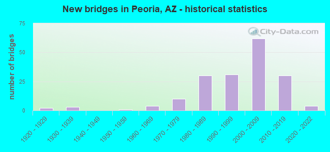
- New bridges - historical statistics
- 21920-1929
- 31930-1939
- 11950-1959
- 41960-1969
- 101970-1979
- 301980-1989
- 311990-1999
- 622000-2009
- 302010-2019
- 42020-2022
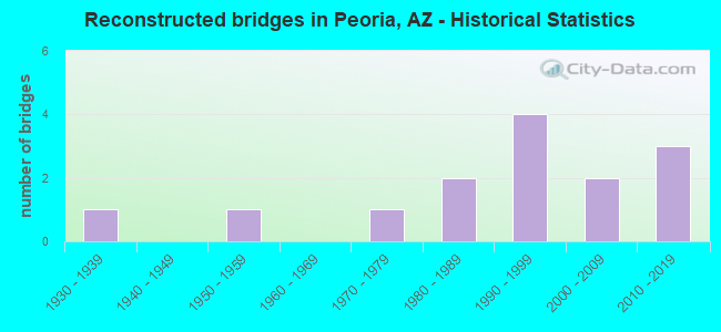
- Reconstructed bridges - Historical Statistics
- 11930-1939
- 01940-1949
- 11950-1959
- 01960-1969
- 11970-1979
- 21980-1989
- 41990-1999
- 22000-2009
- 32010-2019
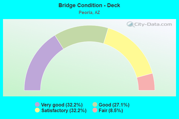
- Bridge Condition - Deck
- 32.2%Very good
- 27.1%Good
- 32.2%Satisfactory
- 8.5%Fair
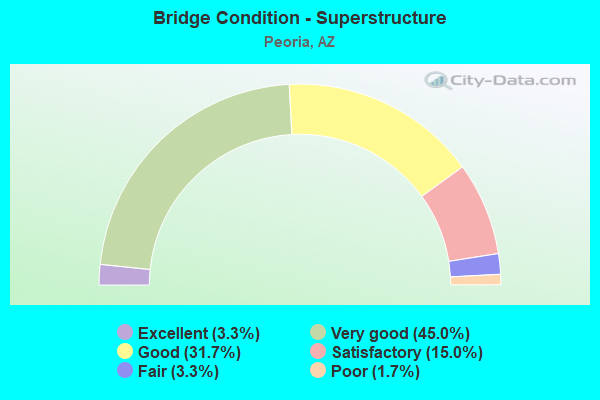
- Bridge Condition - Superstructure
- 3.3%Excellent
- 45.0%Very good
- 31.7%Good
- 15.0%Satisfactory
- 3.3%Fair
- 1.7%Poor
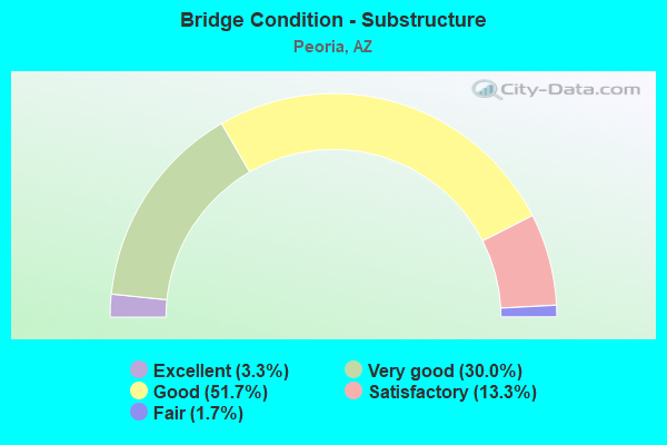
- Bridge Condition - Substructure
- 3.3%Excellent
- 30.0%Very good
- 51.7%Good
- 13.3%Satisfactory
- 1.7%Fair
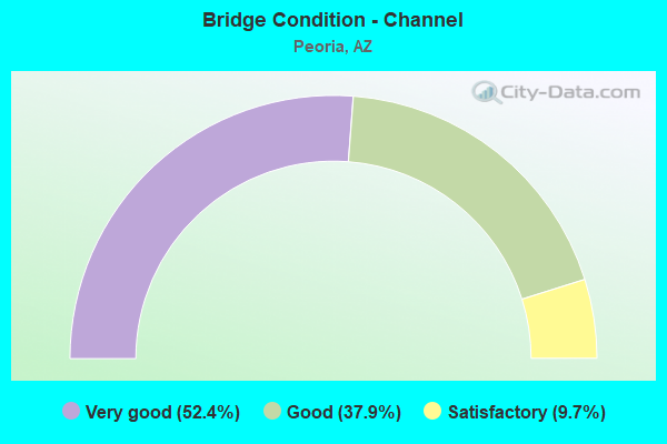
- Bridge Condition - Channel
- 52.4%Very good
- 37.9%Good
- 9.7%Satisfactory
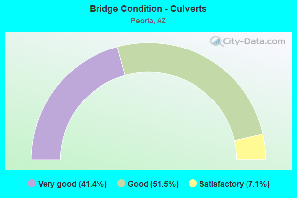
- Bridge Condition - Culverts
- 41.4%Very good
- 51.5%Good
- 7.1%Satisfactory
Find on map >> Show street view
Structure Number: 10932, Location: 0.3 mi W 67th Ave (Lat: 33.750500, Lng: -112.211600), Route carried "on" structure: City street , Year Built: 2005, Status: Open, Structure Length: 1.16m (3.81ft), Average Daily Traffic: 590 (year 2015), Truck Traffic: 1%, Average Future Daily Traffic: 600 (year 2038), Design Load: HS 20, Features Intersected: Drainage Basin, Facility Carried by Structure: N Chalfen Blvd
Minimum Vertical Clearance: 30.45m (99.90ft), Kilometerpoint: 0.000, Lanes on structure: 2, Owner: City or Municipal Highway Agency, Approaching Roadway Width: 9.8m (32.2ft), Material/Design: Concrete continuous, Design/Construction: Culvert, Number Of Spans In Main Unit: 3, Length of Maximum Span: 3.7m (12.1ft), Curb or Sidewalk Widths: Left: 1.5m (4.9ft), Right: 2.4m (7.9ft)
Condition: Channel: Very good, Culverts: Very good, Operating Rating: 89.8 metric tons, Method Used To Determine Operating Rating: Load Factor (LF), Inventory Rating: 76.2 metric tons, Method Used To Determine Inventory Rating: Load Factor (LF), Structural Evaluation: Equal to present desirable criteria, Waterway Adequacy: Equal to present desirable criteria, Approach Roadway Alignment: Equal to present desirable criteria, Designated Inspection Frequency: Every 48 months, Inspection Date: May 2018
Find on map >> Show street view
Structure Number: 10938, Location: @ Jct w/ 98th Ave (Lat: 33.681800, Lng: -112.270500), Route carried "on" structure: City street , Year Built: 2006, Status: Open, Structure Length: 1.04m (3.41ft), Average Daily Traffic: 8,556 (year 2016), Truck Traffic: 5%, Average Future Daily Traffic: 8,566 (year 2038), Design Load: HS 20, Features Intersected: Drainage Basin, Facility Carried by Structure: Deer Valley Rd
Minimum Vertical Clearance: 30+ m (98+ ft), Kilometerpoint: 0.000, Lanes on structure: 5, Owner: City or Municipal Highway Agency, Approaching Roadway Width: 13.4m (44.0ft), Material/Design: Concrete continuous, Design/Construction: Culvert, Number Of Spans In Main Unit: 4, Length of Maximum Span: 2.4m (7.9ft), Curb or Sidewalk Widths: Left: 0.0m, Right: 1.8m (5.9ft)
Condition: Channel: Very good, Culverts: Very good, Operating Rating: 89.8 metric tons, Method Used To Determine Operating Rating: Load Factor (LF), Inventory Rating: 89.8 metric tons, Method Used To Determine Inventory Rating: Load Factor (LF), Structural Evaluation: Equal to present desirable criteria, Waterway Adequacy: Equal to present desirable criteria, Approach Roadway Alignment: Equal to present desirable criteria, Designated Inspection Frequency: Every 48 months, Inspection Date: June 2018
Find on map >> Show street view
Structure Number: 1096, Location: @ Jct w/ 98th Ave (Lat: 33.679500, Lng: -112.270500), Route carried "on" structure: City street , Year Built: 2007, Status: Open, Structure Length: 1.04m (3.41ft), Average Daily Traffic: 500 (year 2018), Truck Traffic: 1%, Average Future Daily Traffic: 510 (year 2038), Design Load: HS 20, Features Intersected: Drainage Basin, Facility Carried by Structure: Melinda Ln
Minimum Vertical Clearance: 30+ m (98+ ft), Kilometerpoint: 0.000, Lanes on structure: 2, Owner: City or Municipal Highway Agency, Approaching Roadway Width: 9.4m (30.8ft), Skew: 1 degrees, Material/Design: Concrete continuous, Design/Construction: Culvert, Number Of Spans In Main Unit: 4, Length of Maximum Span: 2.4m (7.9ft), Curb or Sidewalk Widths: Left: 1.5m (4.9ft), Right: 1.5m (4.9ft)
Condition: Channel: Very good, Culverts: Very good, Operating Rating: 89.8 metric tons, Method Used To Determine Operating Rating: Load Factor (LF), Inventory Rating: 89.8 metric tons, Method Used To Determine Inventory Rating: Load Factor (LF), Structural Evaluation: Equal to present desirable criteria, Waterway Adequacy: Equal to present desirable criteria, Approach Roadway Alignment: Equal to present desirable criteria, Designated Inspection Frequency: Every 48 months, Inspection Date: June 2018
Find on map >> Show street view
Structure Number: 10961, Location: @ Jct w/ 98th Ave (Lat: 33.677300, Lng: -112.270700), Route carried "on" structure: City street , Year Built: 2007, Status: Open, Structure Length: 1.04m (3.41ft), Average Daily Traffic: 500 (year 2018), Truck Traffic: 1%, Average Future Daily Traffic: 510 (year 2038), Design Load: HS 20, Features Intersected: Drainage Basin, Facility Carried by Structure: Quail Ave
Minimum Vertical Clearance: 30+ m (98+ ft), Kilometerpoint: 0.000, Lanes on structure: 2, Owner: City or Municipal Highway Agency, Approaching Roadway Width: 9.4m (30.8ft), Material/Design: Concrete continuous, Design/Construction: Culvert, Number Of Spans In Main Unit: 4, Length of Maximum Span: 2.4m (7.9ft), Curb or Sidewalk Widths: Left: 1.5m (4.9ft), Right: 1.5m (4.9ft)
Condition: Channel: Very good, Culverts: Very good, Operating Rating: 89.8 metric tons, Method Used To Determine Operating Rating: Load Factor (LF), Inventory Rating: 89.8 metric tons, Method Used To Determine Inventory Rating: Load Factor (LF), Structural Evaluation: Equal to present desirable criteria, Waterway Adequacy: Equal to present desirable criteria, Approach Roadway Alignment: Equal to present desirable criteria, Designated Inspection Frequency: Every 48 months, Inspection Date: June 2018
Find on map >> Show street view
Structure Number: 10962, Location: @ Jct w/ 98th Ave (Lat: 33.675300, Lng: -112.270700), Route carried "on" structure: City street , Year Built: 2007, Status: Open, Structure Length: 1.07m (3.51ft), Average Daily Traffic: 500 (year 2018), Truck Traffic: 1%, Average Future Daily Traffic: 510 (year 2038), Design Load: HS 20, Features Intersected: Drainage Basin, Facility Carried by Structure: Harmony Ln
Minimum Vertical Clearance: 30+ m (98+ ft), Kilometerpoint: 0.000, Lanes on structure: 2, Owner: City or Municipal Highway Agency, Approaching Roadway Width: 9.8m (32.2ft), Skew: 31 degrees, Material/Design: Concrete continuous, Design/Construction: Culvert, Number Of Spans In Main Unit: 4, Length of Maximum Span: 2.4m (7.9ft), Curb or Sidewalk Widths: Left: 1.5m (4.9ft), Right: 1.5m (4.9ft)
Condition: Channel: Very good, Culverts: Very good, Operating Rating: 89.8 metric tons, Method Used To Determine Operating Rating: Load Factor (LF), Inventory Rating: 89.8 metric tons, Method Used To Determine Inventory Rating: Load Factor (LF), Structural Evaluation: Equal to present desirable criteria, Waterway Adequacy: Equal to present desirable criteria, Approach Roadway Alignment: Equal to present desirable criteria, Designated Inspection Frequency: Every 48 months, Inspection Date: June 2018
Find on map >> Show street view
Structure Number: 10963, Location: @ Jct w/ Rose Garden Ln (Lat: 33.674600, Lng: -112.246400), Route carried "on" structure: City street , Year Built: 1990, Year Reconstructed: 2001, Status: Open, Structure Length: 0.64m (2.10ft), Average Daily Traffic: 2,172 (year 2015), Truck Traffic: 5%, Average Future Daily Traffic: 2,182 (year 2038), Design Load: HS 20, Features Intersected: Wash, Facility Carried by Structure: N 87th Ave
Minimum Vertical Clearance: 30+ m (98+ ft), Kilometerpoint: 0.000, Lanes on structure: 2, Owner: City or Municipal Highway Agency, Approaching Roadway Width: 15.2m (49.9ft), Material/Design: Concrete continuous, Design/Construction: Culvert, Number Of Spans In Main Unit: 2, Length of Maximum Span: 3.0m (9.8ft), Curb or Sidewalk Widths: Left: 1.5m (4.9ft), Right: 1.5m (4.9ft)
Condition: Channel: Very good, Culverts: Very good, Operating Rating: 52.6 metric tons, Method Used To Determine Operating Rating: Load Factor (LF), Inventory Rating: 31.8 metric tons, Method Used To Determine Inventory Rating: Load Factor (LF), Structural Evaluation: Better than present minimum criteria, Waterway Adequacy: Equal to present desirable criteria, Approach Roadway Alignment: Equal to present desirable criteria, Designated Inspection Frequency: Every 48 months, Inspection Date: May 2018, Deck Structure Type: Concrete Cast-file-Place, Wearing Surface/Protective System: Wearing Surface: Bituminous
Find on map >> Show street view
Structure Number: 10964, Location: 1.0 mi E Jct Vistancia Bl (Lat: 33.758000, Lng: -112.324300), Route carried "on" structure: City street , Year Built: 2004, Status: Open, Structure Length: 1.04m (3.41ft), Average Daily Traffic: 4,742 (year 2017), Truck Traffic: 2%, Average Future Daily Traffic: 4,752 (year 2037), Design Load: HS 20, Features Intersected: Wash, Facility Carried by Structure: Lone Mountain Pkwy
Minimum Vertical Clearance: 30+ m (98+ ft), Kilometerpoint: 0.000, Lanes on structure: 4, Owner: City or Municipal Highway Agency, Approaching Roadway Width: 19.8m (65.0ft), Skew: 30 degrees, Material/Design: Concrete continuous, Design/Construction: Culvert, Number Of Spans In Main Unit: 3, Length of Maximum Span: 3.7m (12.1ft), Curb or Sidewalk Widths: Left: 0.0m, Right: 2.7m (8.9ft)
Condition: Channel: Good, Culverts: Good, Operating Rating: 89.8 metric tons, Method Used To Determine Operating Rating: Load Factor (LF), Inventory Rating: 89.8 metric tons, Method Used To Determine Inventory Rating: Load Factor (LF), Structural Evaluation: Better than present minimum criteria, Waterway Adequacy: Equal to present desirable criteria, Approach Roadway Alignment: Equal to present desirable criteria, Designated Inspection Frequency: Every 48 months, Inspection Date: April 2018
Find on map >> Show street view
Structure Number: 10965, Location: 0.2 mi S Jct Lone Butte (Lat: 33.760900, Lng: -112.338300), Route carried "on" structure: City street , Year Built: 2004, Status: Open, Structure Length: 0.70m (2.30ft), Average Daily Traffic: 3,506 (year 2017), Truck Traffic: 1%, Average Future Daily Traffic: 3,516 (year 2037), Design Load: HS 20, Features Intersected: Drainage Basin, Facility Carried by Structure: N Vistancia Blvd
Minimum Vertical Clearance: 30+ m (98+ ft), Kilometerpoint: 0.000, Lanes on structure: 4, Owner: City or Municipal Highway Agency, Approaching Roadway Width: 21.3m (69.9ft), Skew: 32 degrees, Material/Design: Concrete continuous, Design/Construction: Culvert, Number Of Spans In Main Unit: 2, Length of Maximum Span: 3.4m (11.2ft), Curb or Sidewalk Widths: Left: 2.4m (7.9ft), Right: 0.0m
Condition: Channel: Very good, Culverts: Good, Operating Rating: 89.8 metric tons, Method Used To Determine Operating Rating: Load Factor (LF), Inventory Rating: 89.8 metric tons, Method Used To Determine Inventory Rating: Load Factor (LF), Structural Evaluation: Better than present minimum criteria, Waterway Adequacy: Equal to present desirable criteria, Approach Roadway Alignment: Equal to present desirable criteria, Designated Inspection Frequency: Every 48 months, Inspection Date: April 2018
Find on map >> Show street view
Structure Number: 10966, Location: 0.7 mi W. Jct Vistancia (Lat: 33.763900, Lng: -112.352900), Route carried "on" structure: City street , Year Built: 2004, Status: Open, Structure Length: 0.67m (2.20ft), Average Daily Traffic: 2,097 (year 2017), Truck Traffic: 1%, Average Future Daily Traffic: 2,107 (year 2037), Design Load: HS 20, Features Intersected: Drainage Basin, Facility Carried by Structure: Lone Mt Pkwy
Minimum Vertical Clearance: 30+ m (98+ ft), Kilometerpoint: 0.000, Lanes on structure: 4, Owner: City or Municipal Highway Agency, Approaching Roadway Width: 19.5m (64.0ft), Skew: 32 degrees, Material/Design: Concrete, Design/Construction: Culvert, Number Of Spans In Main Unit: 4, Length of Maximum Span: 1.2m (3.9ft), Curb or Sidewalk Widths: Left: 2.4m (7.9ft), Right: 2.4m (7.9ft)
Condition: Channel: Very good, Culverts: Very good, Operating Rating: 89.8 metric tons, Method Used To Determine Operating Rating: Load Factor (LF), Inventory Rating: 89.8 metric tons, Method Used To Determine Inventory Rating: Load Factor (LF), Structural Evaluation: Equal to present desirable criteria, Waterway Adequacy: Equal to present desirable criteria, Approach Roadway Alignment: Equal to present desirable criteria, Length Of Structure Improvement: 1.40m (4.59ft), Designated Inspection Frequency: Every 48 months, Inspection Date: April 2018, Total Project Cost: $2,000 ( Estimate for 2014)
Find on map >> Show street view
Structure Number: 10988, Location: @ Jct w/ Happy Valley Rd (Lat: 33.711111, Lng: -112.272333), Route carried "on" structure: City street , Year Built: 2006, Year Reconstructed: 2008, Status: Open, Structure Length: 0.67m (2.20ft), Average Daily Traffic: 10,584 (year 2018), Truck Traffic: 10%, Average Future Daily Traffic: 10,594 (year 2038), Design Load: HS 20, Features Intersected: Drainage Wash, Facility Carried by Structure: Lake Pleasant Pkw
Minimum Vertical Clearance: 30+ m (98+ ft), Kilometerpoint: 0.000, Lanes on structure: 7, Owner: City or Municipal Highway Agency, Approaching Roadway Width: 39.9m (130.9ft), Skew: 20 degrees, Material/Design: Concrete continuous, Design/Construction: Culvert, Number Of Spans In Main Unit: 3, Length of Maximum Span: 2.4m (7.9ft), Curb or Sidewalk Widths: Left: 3.4m (11.2ft), Right: 2.3m (7.5ft)
Condition: Channel: Good, Culverts: Very good, Operating Rating: 74.4 metric tons, Method Used To Determine Operating Rating: Load Factor (LF), Inventory Rating: 44.5 metric tons, Method Used To Determine Inventory Rating: Load Factor (LF), Structural Evaluation: Equal to present desirable criteria, Waterway Adequacy: Equal to present desirable criteria, Approach Roadway Alignment: Equal to present desirable criteria, Designated Inspection Frequency: Every 48 months, Inspection Date: April 2020
Find on map >> Show street view
Structure Number: 10989, Location: _ (Lat: 33.717861, Lng: -112.272111), Route carried "on" structure: City street , Year Built: 2008, Status: Open, Structure Length: 1.34m (4.40ft), Average Daily Traffic: 1,969 (year 2015), Truck Traffic: 5%, Average Future Daily Traffic: 1,979 (year 2036), Design Load: HS 20, Features Intersected: Drainage Basin, Facility Carried by Structure: W Yearling Rd
Minimum Vertical Clearance: 30+ m (98+ ft), Kilometerpoint: 0.000, Lanes on structure: 3, Owner: City or Municipal Highway Agency, Approaching Roadway Width: 7.6m (24.9ft), Skew: 2 degrees, Material/Design: Concrete continuous, Design/Construction: Culvert, Number Of Spans In Main Unit: 6, Length of Maximum Span: 1.8m (5.9ft), Curb or Sidewalk Widths: Left: 1.8m (5.9ft), Right: 0.0m
Condition: Channel: Very good, Culverts: Very good, Operating Rating: 89.8 metric tons, Method Used To Determine Operating Rating: Load Factor (LF), Inventory Rating: 89.8 metric tons, Method Used To Determine Inventory Rating: Load Factor (LF), Structural Evaluation: Equal to present desirable criteria, Waterway Adequacy: Equal to present desirable criteria, Approach Roadway Alignment: Equal to present desirable criteria, Designated Inspection Frequency: Every 48 months, Inspection Date: April 2020
Find on map >> Show street view
Structure Number: 1099, Location: @ Jct w/Rose Garden Ln (Lat: 33.674700, Lng: -112.279900), Route carried "on" structure: City street , Year Built: 2007, Status: Open, Structure Length: 1.34m (4.40ft), Average Daily Traffic: 11,965 (year 2017), Truck Traffic: 5%, Average Future Daily Traffic: 11,975 (year 2038), Design Load: HS 20, Features Intersected: Drainage Basin, Facility Carried by Structure: Lake Pleasant Rd
Minimum Vertical Clearance: 30+ m (98+ ft), Kilometerpoint: 0.000, Lanes on structure: 6, Owner: City or Municipal Highway Agency, Approaching Roadway Width: 25.6m (84.0ft), Skew: 20 degrees, Material/Design: Concrete continuous, Design/Construction: Culvert, Number Of Spans In Main Unit: 5, Length of Maximum Span: 2.4m (7.9ft), Curb or Sidewalk Widths: Left: 1.8m (5.9ft), Right: 2.4m (7.9ft)
Condition: Channel: Very good, Culverts: Very good, Operating Rating: 89.8 metric tons, Method Used To Determine Operating Rating: Load Factor (LF), Inventory Rating: 89.8 metric tons, Method Used To Determine Inventory Rating: Load Factor (LF), Structural Evaluation: Equal to present desirable criteria, Waterway Adequacy: Equal to present desirable criteria, Approach Roadway Alignment: Equal to present desirable criteria, Designated Inspection Frequency: Every 48 months, Inspection Date: June 2018
Find on map >> Show street view
Structure Number: 10991, Location: 0.6 mi W Jct 95th Ave (Lat: 33.675100, Lng: -112.274300), Route carried "on" structure: City street , Year Built: 2007, Status: Open, Structure Length: 1.34m (4.40ft), Average Daily Traffic: 23,824 (year 2017), Truck Traffic: 5%, Average Future Daily Traffic: 23,834 (year 2038), Design Load: HS 20, Features Intersected: Drainage Basin, Facility Carried by Structure: Lake Pleasant Pkwy
Minimum Vertical Clearance: 30+ m (98+ ft), Kilometerpoint: 0.000, Lanes on structure: 5, Owner: City or Municipal Highway Agency, Approaching Roadway Width: 23.8m (78.1ft), Skew: 20 degrees, Material/Design: Concrete continuous, Design/Construction: Culvert, Number Of Spans In Main Unit: 5, Length of Maximum Span: 2.4m (7.9ft), Curb or Sidewalk Widths: Left: 2.4m (7.9ft), Right: 2.4m (7.9ft)
Condition: Channel: Very good, Culverts: Very good, Operating Rating: 89.8 metric tons, Method Used To Determine Operating Rating: Load Factor (LF), Inventory Rating: 89.8 metric tons, Method Used To Determine Inventory Rating: Load Factor (LF), Structural Evaluation: Equal to present desirable criteria, Waterway Adequacy: Equal to present desirable criteria, Approach Roadway Alignment: Equal to present desirable criteria, Designated Inspection Frequency: Every 48 months, Inspection Date: June 2018
Find on map >> Show street view
Structure Number: 10992, Location: 0.1 mi S Jct Williams Dr (Lat: 33.687500, Lng: -112.279583), Route carried "on" structure: City street , Year Built: 2005, Status: Open, Structure Length: 0.82m (2.69ft), Average Daily Traffic: 20,104 (year 2018), Truck Traffic: 5%, Average Future Daily Traffic: 20,114 (year 2038), Design Load: HS 20, Features Intersected: Drainage Basin, Facility Carried by Structure: Lake Pleasant Pkwy
Minimum Vertical Clearance: 30+ m (98+ ft), Kilometerpoint: 0.000, Lanes on structure: 4, Owner: City or Municipal Highway Agency, Approaching Roadway Width: 19.5m (64.0ft), Skew: 24 degrees, Material/Design: Concrete continuous, Design/Construction: Culvert, Number Of Spans In Main Unit: 4, Length of Maximum Span: 1.5m (4.9ft), Curb or Sidewalk Widths: Left: 2.3m (7.5ft), Right: 0.0m
Condition: Channel: Very good, Culverts: Very good, Operating Rating: 64.4 metric tons, Method Used To Determine Operating Rating: Load Factor (LF), Inventory Rating: 37.2 metric tons, Method Used To Determine Inventory Rating: Load Factor (LF), Structural Evaluation: Equal to present desirable criteria, Waterway Adequacy: Equal to present desirable criteria, Approach Roadway Alignment: Equal to present desirable criteria, Designated Inspection Frequency: Every 48 months, Inspection Date: April 2020
Find on map >> Show street view
Structure Number: 10999, Location: @Jct w/Beardsley (Lat: 33.667400, Lng: -112.276100), Route carried "on" structure: City street , Year Built: 1998, Status: Open, Structure Length: 0.79m (2.59ft), Average Daily Traffic: 1,000 (year 2018), Truck Traffic: 1%, Average Future Daily Traffic: 1,010 (year 2038), Design Load: HS 20, Features Intersected: Wash, Facility Carried by Structure: N 101st Avenue
Minimum Vertical Clearance: 9.14m (29.99ft), Kilometerpoint: 0.000, Lanes on structure: 2, Owner: City or Municipal Highway Agency, Approaching Roadway Width: 12.5m (41.0ft), Skew: 1 degrees, Material/Design: Concrete continuous, Design/Construction: Culvert, Number Of Spans In Main Unit: 3, Length of Maximum Span: 2.4m (7.9ft), Curb or Sidewalk Widths: Left: 1.4m (4.6ft), Right: 1.4m (4.6ft)
Condition: Channel: Very good, Culverts: Very good, Operating Rating: 49.0 metric tons, Method Used To Determine Operating Rating: Load Factor (LF), Inventory Rating: 29.0 metric tons, Method Used To Determine Inventory Rating: Load Factor (LF), Structural Evaluation: Better than present minimum criteria, Waterway Adequacy: Equal to present desirable criteria, Approach Roadway Alignment: Equal to present desirable criteria, Designated Inspection Frequency: Every 48 months, Inspection Date: June 2018, Deck Structure Type: Concrete Cast-file-Place, Wearing Surface/Protective System: Wearing Surface: Monolithic Concrete
Find on map >> Show street view
Structure Number: 11001, Location: @ Jct w/67th Ave (Lat: 33.718100, Lng: -112.203600), Route carried "on" structure: City street , Year Built: 1998, Status: Open, Structure Length: 1.31m (4.30ft), Average Daily Traffic: 4,463 (year 2016), Truck Traffic: 5%, Average Future Daily Traffic: 4,473 (year 2038), Design Load: HS 20, Features Intersected: Wash, Facility Carried by Structure: W Desert Moon Way
Minimum Vertical Clearance: 30+ m (98+ ft), Kilometerpoint: 0.000, Lanes on structure: 3, Owner: City or Municipal Highway Agency, Approaching Roadway Width: 13.4m (44.0ft), Skew: 20 degrees, Material/Design: Concrete continuous, Design/Construction: Culvert, Number Of Spans In Main Unit: 4, Length of Maximum Span: 3.0m (9.8ft), Curb or Sidewalk Widths: Left: 1.5m (4.9ft), Right: 1.5m (4.9ft)
Condition: Channel: Very good, Culverts: Very good, Operating Rating: 89.8 metric tons, Method Used To Determine Operating Rating: Load Factor (LF), Inventory Rating: 89.8 metric tons, Method Used To Determine Inventory Rating: Load Factor (LF), Structural Evaluation: Equal to present desirable criteria, Waterway Adequacy: Equal to present desirable criteria, Approach Roadway Alignment: Equal to present desirable criteria, Designated Inspection Frequency: Every 48 months, Inspection Date: May 2018
Find on map >> Show street view
Structure Number: 11004, Location: @ Jct w/ Rose Garden Ln (Lat: 33.674700, Lng: -112.294300), Route carried "on" structure: City street , Year Built: 2008, Status: Open, Structure Length: 1.01m (3.31ft), Average Daily Traffic: 1,000 (year 2018), Truck Traffic: 1%, Average Future Daily Traffic: 1,010 (year 2038), Design Load: HS 20, Features Intersected: Drainage Wash, Facility Carried by Structure: 21000 N 109th Ave
Minimum Vertical Clearance: 30+ m (98+ ft), Kilometerpoint: 0.000, Lanes on structure: 2, Owner: City or Municipal Highway Agency, Approaching Roadway Width: 7.3m (24.0ft), Skew: 1 degrees, Material/Design: Concrete continuous, Design/Construction: Culvert, Number Of Spans In Main Unit: 3, Length of Maximum Span: 3.0m (9.8ft)
Condition: Channel: Very good, Culverts: Very good, Operating Rating: 63.5 metric tons, Method Used To Determine Operating Rating: Load Factor (LF), Inventory Rating: 38.1 metric tons, Method Used To Determine Inventory Rating: Load Factor (LF), Structural Evaluation: Equal to present desirable criteria, Waterway Adequacy: Equal to present desirable criteria, Approach Roadway Alignment: Equal to present desirable criteria, Designated Inspection Frequency: Every 48 months, Inspection Date: June 2018
Find on map >> Show street view
Structure Number: 11006, Location: 0.7 mi E of Dysart Rd (Lat: 33.713239, Lng: -112.331244), Route carried "on" structure: County highway , Year Built: 2006, Status: Open, Structure Length: 3.20m (10.50ft), Average Daily Traffic: 3,005 (year 2018), Truck Traffic: 2%, Average Future Daily Traffic: 3,015 (year 2038), Design Load: HS 20, Features Intersected: Trilby Wash, Facility Carried by Structure: Happy Valley Road
Minimum Vertical Clearance: 30+ m (98+ ft), Kilometerpoint: 0.000, Lanes on structure: 4, Owner: County Highway Agency, Approaching Roadway Width: 18.9m (62.0ft), Skew: 23 degrees, Material/Design: Concrete continuous, Design/Construction: Culvert, Number Of Spans In Main Unit: 8, Length of Maximum Span: 3.7m (12.1ft)
Condition: Channel: Good, Culverts: Good, Structural Evaluation: Better than present minimum criteria, Waterway Adequacy: Equal to present desirable criteria, Approach Roadway Alignment: Equal to present minimum criteria, Designated Inspection Frequency: Every 48 months, Inspection Date: January 2020
Find on map >> Show street view
Structure Number: 11165, Location: 0.5 m W fr jt 303 (Lat: 33.748333, Lng: -112.305000), Route carried "on" structure: City street , Year Built: 2011, Status: Open, Structure Length: 0.70m (2.30ft), Average Daily Traffic: 9,228 (year 2018), Truck Traffic: 5%, Average Future Daily Traffic: 9,238 (year 2038), Design Load: HS 20, Features Intersected: Wash, Facility Carried by Structure: Lone Mountain Pkwy
Minimum Vertical Clearance: 9.14m (29.99ft), Kilometerpoint: 0.000, Lanes on structure: 2, Owner: City or Municipal Highway Agency, Approaching Roadway Width: 14.6m (47.9ft), Skew: 24 degrees, Material/Design: Concrete continuous, Design/Construction: Culvert, Number Of Spans In Main Unit: 2, Length of Maximum Span: 2.4m (7.9ft), Curb or Sidewalk Widths: Left: 2.3m (7.5ft), Right: 2.3m (7.5ft)
Condition: Channel: Very good, Culverts: Good, Operating Rating: 89.8 metric tons, Method Used To Determine Operating Rating: Load Factor (LF), Inventory Rating: 89.8 metric tons, Method Used To Determine Inventory Rating: Load Factor (LF), Structural Evaluation: Better than present minimum criteria, Waterway Adequacy: Equal to present desirable criteria, Approach Roadway Alignment: Equal to present desirable criteria, Designated Inspection Frequency: Every 48 months, Inspection Date: April 2020
Find on map >> Show street view
Structure Number: 11484, Location: Corner N78th AV & Calle L (Lat: 33.703475, Lng: -112.227836), Route carried "on" structure: City street , Year Built: 2015, Status: Open, Structure Length: 1.65m (5.41ft), Average Daily Traffic: 50 (year 2016), Average Future Daily Traffic: 60 (year 2036), Design Load: HS 20, Features Intersected: Drainage Basin, Facility Carried by Structure: Calle Lejos
Minimum Vertical Clearance: 30+ m (98+ ft), Kilometerpoint: 0.000, Lanes on structure: 2, Owner: City or Municipal Highway Agency, Approaching Roadway Width: 8.8m (28.9ft), Material/Design: Concrete continuous, Design/Construction: Culvert, Number Of Spans In Main Unit: 5, Length of Maximum Span: 3.0m (9.8ft), Curb-To-Curb Width: 8.8m (28.9ft), Out-to-Out Width: 15.2m (49.9ft)
Condition: Channel: Very good, Culverts: Very good, Operating Rating: 53.5 metric tons, Method Used To Determine Operating Rating: Load Factor (LF), Inventory Rating: 32.7 metric tons, Method Used To Determine Inventory Rating: Load Factor (LF), Structural Evaluation: Equal to present desirable criteria, Deck Geometry: Better than present minimum criteria, Waterway Adequacy: Equal to present desirable criteria, Approach Roadway Alignment: Equal to present desirable criteria, Designated Inspection Frequency: Every 48 months, Inspection Date: April 2020, Deck Structure Type: Concrete Cast-file-Place, Wearing Surface/Protective System: Wearing Surface: Bituminous
Find on map >> Show street view
Structure Number: 11485, Location: 98th AV + Via Montoya Dr (Lat: 33.686200, Lng: -112.272100), Route carried "on" structure: City street , Year Built: 2015, Status: Open, Structure Length: 0.78m (2.56ft), Average Daily Traffic: 320 (year 2018), Average Future Daily Traffic: 330 (year 2018), Design Load: HS 20, Features Intersected: Drainage Basin, Facility Carried by Structure: Via Montoya Dr
Minimum Vertical Clearance: 30+ m (98+ ft), Kilometerpoint: 0.000, Lanes on structure: 2, Owner: City or Municipal Highway Agency, Approaching Roadway Width: 9.8m (32.2ft), Material/Design: Concrete continuous, Design/Construction: Culvert, Number Of Spans In Main Unit: 3, Length of Maximum Span: 2.4m (7.9ft), Curb or Sidewalk Widths: Left: 1.5m (4.9ft), Right: 1.5m (4.9ft)
Condition: Channel: Very good, Culverts: Very good, Operating Rating: 74.4 metric tons, Method Used To Determine Operating Rating: Load Factor (LF), Inventory Rating: 40.8 metric tons, Method Used To Determine Inventory Rating: Load Factor (LF), Structural Evaluation: Equal to present desirable criteria, Waterway Adequacy: Equal to present desirable criteria, Approach Roadway Alignment: Equal to present desirable criteria, Designated Inspection Frequency: Every 48 months, Inspection Date: June 2020
Find on map >> Show street view
Structure Number: 11486, Location: Int 98th AV + Via Del Sol (Lat: 33.682700, Lng: -112.270600), Route carried "on" structure: City street , Year Built: 2015, Status: Open, Structure Length: 0.79m (2.59ft), Average Daily Traffic: 210 (year 2018), Truck Traffic: 1%, Average Future Daily Traffic: 220 (year 2038), Design Load: HS 20, Features Intersected: Drainage Basin, Facility Carried by Structure: Via Del Sol
Minimum Vertical Clearance: 30+ m (98+ ft), Kilometerpoint: 0.000, Lanes on structure: 2, Owner: City or Municipal Highway Agency, Approaching Roadway Width: 9.8m (32.2ft), Material/Design: Concrete continuous, Design/Construction: Culvert, Number Of Spans In Main Unit: 3, Length of Maximum Span: 2.4m (7.9ft), Curb or Sidewalk Widths: Left: 1.5m (4.9ft), Right: 1.5m (4.9ft)
Condition: Channel: Very good, Culverts: Very good, Operating Rating: 89.8 metric tons, Method Used To Determine Operating Rating: Load Factor (LF), Inventory Rating: 89.8 metric tons, Method Used To Determine Inventory Rating: Load Factor (LF), Structural Evaluation: Equal to present desirable criteria, Waterway Adequacy: Equal to present desirable criteria, Approach Roadway Alignment: Equal to present desirable criteria, Designated Inspection Frequency: Every 48 months, Inspection Date: June 2020
Find on map >> Show street view
Structure Number: 11487, Location: Int of 98th AV+SpecG. Dr. (Lat: 33.684900, Lng: -112.272100), Route carried "on" structure: City street , Year Built: 2015, Status: Posted for load, Structure Length: 0.82m (2.69ft), Average Daily Traffic: 710 (year 2018), Truck Traffic: 1%, Average Future Daily Traffic: 720 (year 2038), Design Load: HS 20, Features Intersected: Drainage Basin, Facility Carried by Structure: Speckled Gecko Dr
Minimum Vertical Clearance: 30+ m (98+ ft), Kilometerpoint: 0.000, Lanes on structure: 2, Owner: City or Municipal Highway Agency, Approaching Roadway Width: 5.5m (18.0ft), Skew: 22 degrees, Material/Design: Concrete continuous, Design/Construction: Culvert, Number Of Spans In Main Unit: 3, Length of Maximum Span: 2.4m (7.9ft), Curb or Sidewalk Widths: Left: 2.1m (6.9ft), Right: 2.1m (6.9ft)
Condition: Channel: Very good, Culverts: Very good, Operating Rating: 74.4 metric tons, Method Used To Determine Operating Rating: Load Factor (LF), Inventory Rating: 40.8 metric tons, Method Used To Determine Inventory Rating: Load Factor (LF), Structural Evaluation: Equal to present desirable criteria, Waterway Adequacy: Equal to present desirable criteria, Approach Roadway Alignment: Equal to present desirable criteria, Designated Inspection Frequency: Every 48 months, Inspection Date: June 2020
Find on map >> Show street view
Structure Number: 11488, Location: Int. 29th AV +Westland Rd (Lat: 33.773128, Lng: -112.337797), Route carried "on" structure: City street , Year Built: 2015, Status: Open, Structure Length: 2.01m (6.59ft), Average Daily Traffic: 1,000 (year 2016), Truck Traffic: 2%, Average Future Daily Traffic: 1,010 (year 2036), Design Load: HS 20, Features Intersected: Drainage Basin, Facility Carried by Structure: Westland Rd
Minimum Vertical Clearance: 30+ m (98+ ft), Kilometerpoint: 0.000, Lanes on structure: 2, Owner: City or Municipal Highway Agency, Approaching Roadway Width: 9.8m (32.2ft), Skew: 3 degrees, Material/Design: Concrete continuous, Design/Construction: Culvert, Number Of Spans In Main Unit: 5, Length of Maximum Span: 3.0m (9.8ft)
Condition: Channel: Very good, Culverts: Very good, Operating Rating: 89.8 metric tons, Method Used To Determine Operating Rating: Load Factor (LF), Inventory Rating: 89.8 metric tons, Method Used To Determine Inventory Rating: Load Factor (LF), Structural Evaluation: Equal to present desirable criteria, Waterway Adequacy: Equal to present desirable criteria, Approach Roadway Alignment: Equal to present desirable criteria, Designated Inspection Frequency: Every 48 months, Inspection Date: April 2020
Find on map >> Show street view
Structure Number: 20171, Location: _ (Lat: 33.744200, Lng: -112.299000), Route carried "on" structure: State highway 303, Year Built: 2021, Status: Open, Structure Length: 7.50m (24.61ft), Average Daily Traffic: 10,162 (year 2020), Truck Traffic: 10%, Average Future Daily Traffic: 10,172 (year 2040), Design Load: HL 93, Features Intersected: Jomax Parkway, Facility Carried by Structure: BobStumpMemorial
Minimum Vertical Clearance: 30.45m (99.90ft), Kilometerpoint: 204.097, Lanes on structure: 3, Lanes under structure: 10, Owner: State Highway Agency, Approaching Roadway Width: 17.7m (58.1ft), Material/Design: Prestressed concrete continuous, Design/Construction: Stringer/Multi-beam, Number Of Spans In Main Unit: 2, Length of Maximum Span: 36.6m (120.1ft), Curb-To-Curb Width: 17.7m (58.1ft), Out-to-Out Width: 18.5m (60.7ft)
Condition: Deck: Very good, Superstructure: Excellent, Substructure: Excellent, Operating Rating: 32.7 metric tons, Method Used To Determine Operating Rating: No rating analysis performed, Inventory Rating: 32.7 metric tons, Method Used To Determine Inventory Rating: No rating analysis performed, Structural Evaluation: Superior to present desirable criteria, Deck Geometry: Better than present minimum criteria, Underclear: High priority of corrective action, Approach Roadway Alignment: Equal to present desirable criteria, Designated Inspection Frequency: Every 24 months, Inspection Date: October 2021, Deck Structure Type: Concrete Cast-file-Place
Find on map >> Show street view
Structure Number: 20172, Location: _ (Lat: 33.744400, Lng: -112.299200), Route carried "on" structure: State highway 303, Year Built: 2021, Status: Open, Structure Length: 7.50m (24.61ft), Average Daily Traffic: 7,049 (year 2020), Truck Traffic: 10%, Average Future Daily Traffic: 7,059 (year 2040), Design Load: HL 93, Features Intersected: Jomax Parkway, Facility Carried by Structure: BobStumpMemorial
Minimum Vertical Clearance: 30.45m (99.90ft), Kilometerpoint: 204.097, Lanes on structure: 3, Lanes under structure: 10, Owner: State Highway Agency, Approaching Roadway Width: 17.7m (58.1ft), Material/Design: Prestressed concrete continuous, Design/Construction: Stringer/Multi-beam, Number Of Spans In Main Unit: 2, Length of Maximum Span: 36.6m (120.1ft), Curb-To-Curb Width: 17.7m (58.1ft), Out-to-Out Width: 18.5m (60.7ft)
Condition: Deck: Very good, Superstructure: Excellent, Substructure: Excellent, Operating Rating: 32.7 metric tons, Method Used To Determine Operating Rating: No rating analysis performed, Inventory Rating: 32.7 metric tons, Method Used To Determine Inventory Rating: No rating analysis performed, Structural Evaluation: Superior to present desirable criteria, Deck Geometry: Better than present minimum criteria, Underclear: High priority of corrective action, Approach Roadway Alignment: Equal to present desirable criteria, Designated Inspection Frequency: Every 24 months, Inspection Date: October 2021, Deck Structure Type: Concrete Cast-file-Place
Find on map >> Show street view
Structure Number: 16, Location: 8.5 mi W Jct I 17 (Lat: 33.564700, Lng: -112.217400), Route carried "under" structure: US 60, Year Built: 1936, Structure Length: 0. m, Average Daily Traffic: 17,260 (year 2017), Truck Traffic: 4%, Features Intersected: US 60; WB, Facility Carried by Structure: ATSF Railroad
Minimum Vertical Clearance: 5.18m (16.99ft), Kilometerpoint: 244.942, Lanes under structure: 3, Material/Design: Steel, Design/Construction: Girder and Floorbeam System, Length of Maximum Span: 26.2m (86.0ft)
Find on map >> Show street view
Structure Number: 1621, Location: 9.3 mi W Jct I 17 (Lat: 33.827900, Lng: -112.274100), Route carried "under" structure: ServiceOther road , Year Built: 1972, Structure Length: 0. m, Average Daily Traffic: 5 (year 2019), Truck Traffic: 1%, Features Intersected: Beardsley Canal, Facility Carried by Structure: SR 74
Minimum Vertical Clearance: 4.50m (14.76ft), Kilometerpoint: 0.000, Lanes on structure: 3, Lanes under structure: 3, Material/Design: Prestressed concrete, Design/Construction: Stringer/Multi-beam, Length of Maximum Span: 32.0m (105.0ft)
Find on map >> Show street view
Structure Number: 2034, Location: 8.06 mi N Jct I-10 (Lat: 33.551300, Lng: -112.266900), Route carried "under" structure: City street , Year Built: 1987, Structure Length: 0. m, Average Daily Traffic: 32,850 (year 2020), Truck Traffic: 5%, Features Intersected: Northern Ave, Facility Carried by Structure: Loop 101
Minimum Vertical Clearance: 5.21m (17.09ft), Kilometerpoint: 0.000, Lanes on structure: 8, Lanes under structure: 8, Material/Design: Prestressed concrete continuous, Design/Construction: Box Beam or Girders - Single/Spread, Length of Maximum Span: 34.1m (111.9ft)
Find on map >> Show street view
Structure Number: 2035, Location: 9.27 mi N Jct I-10 (Lat: 33.566000, Lng: -112.257200), Route carried "under" structure: City street , Year Built: 1987, Structure Length: 0. m, Average Daily Traffic: 32,063 (year 2020), Truck Traffic: 5%, Features Intersected: Olive Ave, Facility Carried by Structure: Loop 101
Minimum Vertical Clearance: 5.35m (17.55ft), Kilometerpoint: 0.000, Lanes on structure: 8, Lanes under structure: 8, Material/Design: Prestressed concrete, Design/Construction: Box Beam or Girders - Single/Spread, Length of Maximum Span: 48.2m (158.1ft)
Find on map >> Show street view
Structure Number: 2036, Location: 10.28 mi N Jct SR 85 (Lat: 33.580500, Lng: -112.259400), Route carried "under" structure: City street , Year Built: 1987, Structure Length: 0. m, Average Daily Traffic: 19,025 (year 2020), Truck Traffic: 2%, Features Intersected: Peoria Ave, Facility Carried by Structure: Loop 101
Minimum Vertical Clearance: 5.39m (17.68ft), Kilometerpoint: 0.000, Lanes on structure: 8, Lanes under structure: 8, Material/Design: Prestressed concrete, Design/Construction: Box Beam or Girders - Single/Spread, Length of Maximum Span: 51.8m (169.9ft)
Find on map >> Show street view
Structure Number: 2039, Location: 1.43 mi N of Jct US 60 (Lat: 33.609700, Lng: -112.244600), Route carried "under" structure: City street , Year Built: 1989, Structure Length: 0. m, Average Daily Traffic: 32,917 (year 2020), Truck Traffic: 5%, Features Intersected: Thunderbird Road, Facility Carried by Structure: Loop 101
Minimum Vertical Clearance: 5.49m (18.01ft), Kilometerpoint: 0.000, Lanes on structure: 8, Lanes under structure: 8, Material/Design: Prestressed concrete continuous, Design/Construction: Box Beam or Girders - Single/Spread, Length of Maximum Span: 39.9m (130.9ft)
Find on map >> Show street view
Structure Number: 2047, Location: at Jct with 101L (Lat: 33.594000, Lng: -112.260700), Route carried "under" structure: State highway 101, Year Built: 1988, Structure Length: 0. m, Average Daily Traffic: 138,625 (year 2018), Truck Traffic: 5%, Features Intersected: Loop 101, Facility Carried by Structure: US 60
Minimum Vertical Clearance: 5.54m (18.18ft), Kilometerpoint: 18.057, Lanes on structure: 8, Lanes under structure: 8, Material/Design: Prestressed concrete continuous, Design/Construction: Box Beam or Girders - Single/Spread, Length of Maximum Span: 28.0m (91.9ft)
Find on map >> Show street view
Structure Number: 2049, Location: 100 ft N of Jct US 60 - L (Lat: 33.594500, Lng: -112.260700), Route carried "under" structure: State highway 101, Year Built: 1988, Structure Length: 0. m, Average Daily Traffic: 113,128 (year 2019), Truck Traffic: 7%, Features Intersected: Loop 101, Facility Carried by Structure: AT & SF RR
Minimum Vertical Clearance: 5.53m (18.14ft), Kilometerpoint: 18.105, Material/Design: Prestressed concrete continuous, Design/Construction: Box Beam or Girders - Single/Spread, Length of Maximum Span: 28.0m (91.9ft)
Find on map >> Show street view
Structure Number: 205, Location: 0.3 mi N of Jct US 60 (Lat: 33.637900, Lng: -112.237800), Route carried "under" structure: City street , Year Built: 1990, Structure Length: 0. m, Average Daily Traffic: 39,772 (year 2020), Truck Traffic: 5%, Features Intersected: Bell Road, Facility Carried by Structure: Loop 101
Minimum Vertical Clearance: 5.26m (17.26ft), Kilometerpoint: 0.000, Lanes on structure: 8, Lanes under structure: 8, Material/Design: Prestressed concrete, Design/Construction: Box Beam or Girders - Multiple, Length of Maximum Span: 61.0m (200.1ft)
Find on map >> Show street view
Structure Number: 2322, Location: 6.4 mi N Jct US 60 (Lat: 33.713500, Lng: -112.310700), Route carried "under" structure: City street , Year Built: 2010, Structure Length: 0. m, Average Daily Traffic: 33,257 (year 2019), Truck Traffic: 5%, Features Intersected: Happy Valley Pkwy, Facility Carried by Structure: SR 303L
Minimum Vertical Clearance: 5.93m (19.46ft), Kilometerpoint: 0.000, Lanes on structure: 2, Lanes under structure: 7, Material/Design: Prestressed concrete continuous, Design/Construction: Box Beam or Girders - Single/Spread, Length of Maximum Span: 56.4m (185.0ft)
Find on map >> Show street view
Structure Number: 2323, Location: 6.4 mi N Jct US 60 (Lat: 33.713100, Lng: -112.311297), Route carried "under" structure: City street , Year Built: 2010, Structure Length: 0. m, Average Daily Traffic: 33,257 (year 2019), Truck Traffic: 5%, Features Intersected: Happy Valley Pkwy, Facility Carried by Structure: SR 303L
Minimum Vertical Clearance: 5.32m (17.45ft), Kilometerpoint: 0.000, Lanes on structure: 2, Lanes under structure: 7, Material/Design: Prestressed concrete continuous, Design/Construction: Box Beam or Girders - Single/Spread, Length of Maximum Span: 56.4m (185.0ft)
Find on map >> Show street view
Structure Number: 2388, Location: 8.7 mi N. Jct US 60 (Lat: 33.743753, Lng: -112.299272), Route carried "under" structure: City street , Year Built: 2010, Structure Length: 0. m, Average Daily Traffic: 1,723 (year 2018), Truck Traffic: 1%, Features Intersected: Lone Mtn Pkwy, Facility Carried by Structure: SR 303L
Minimum Vertical Clearance: 6.08m (19.95ft), Kilometerpoint: 0.000, Lanes on structure: 2, Lanes under structure: 2, Material/Design: Prestressed concrete continuous, Design/Construction: Box Beam or Girders - Single/Spread, Length of Maximum Span: 56.4m (185.0ft)
Find on map >> Show street view
Structure Number: 239, Location: 8.7 mi N. Jct US 60 (Lat: 33.743850, Lng: -112.299631), Route carried "under" structure: City street , Year Built: 2010, Structure Length: 0. m, Average Daily Traffic: 1,760 (year 2019), Features Intersected: Lone Mtn Pkwy, Facility Carried by Structure: SR 303L
Minimum Vertical Clearance: 5.52m (18.11ft), Kilometerpoint: 0.000, Lanes on structure: 2, Lanes under structure: 2, Material/Design: Prestressed concrete continuous, Design/Construction: Box Beam or Girders - Single/Spread, Length of Maximum Span: 56.4m (185.0ft)
Find on map >> Show street view
Structure Number: 2467, Location: 7.3 mi W Jct I-17 (Lat: 33.769700, Lng: -112.249900), Route carried "under" structure: State highway 303, Year Built: 2010, Structure Length: 0. m, Average Daily Traffic: 13,812 (year 2017), Truck Traffic: 7%, Features Intersected: SR 303L, Facility Carried by Structure: Lake Pleasant Pkwy
Minimum Vertical Clearance: 5.68m (18.64ft), Kilometerpoint: 212.015, Lanes on structure: 8, Lanes under structure: 4, Material/Design: Prestressed concrete continuous, Design/Construction: Box Beam or Girders - Single/Spread, Length of Maximum Span: 48.8m (160.1ft)
Find on map >> Show street view
Structure Number: 2646, Location: 0.3 m N Grand Ave @ L101 (Lat: 33.599500, Lng: -112.255700), Route carried "under" structure: State highway 101, Year Built: 2002, Structure Length: 0. m, Average Daily Traffic: 113,128 (year 2019), Truck Traffic: 5%, Features Intersected: Loop 101, Facility Carried by Structure: Ramp to 91st. Ave.
Minimum Vertical Clearance: 6.49m (21.29ft), Kilometerpoint: 18.910, Lanes on structure: 1, Lanes under structure: 8, Material/Design: Prestressed concrete continuous, Design/Construction: Box Beam or Girders - Single/Spread, Length of Maximum Span: 63.1m (207.0ft)
Find on map >> Show street view
Structure Number: 2697, Location: Grand Ave@ Olive/ 75th Av (Lat: 33.566500, Lng: -112.220600), Route carried "under" structure: US 60, Year Built: 2005, Structure Length: 0. m, Average Daily Traffic: 34,390 (year 2018), Truck Traffic: 4%, Features Intersected: US60 & 75th Ave, Facility Carried by Structure: Olive Ave
Minimum Vertical Clearance: 7.27m (23.85ft), Kilometerpoint: 244.620, Lanes on structure: 4, Lanes under structure: 13, Material/Design: Prestressed concrete continuous, Design/Construction: Stringer/Multi-beam, Length of Maximum Span: 42.1m (138.1ft)
Find on map >> Show street view
Structure Number: 20171, Location: _ (Lat: 33.744200, Lng: -112.299000), Route carried "under" structure: City street , Year Built: 2021, Structure Length: 0. m, Average Daily Traffic: 13,545 (year 2020), Truck Traffic: 5%, Features Intersected: Jomax Parkway, Facility Carried by Structure: BobStumpMemorial
Minimum Vertical Clearance: 0.00m, Kilometerpoint: 0.000, Lanes on structure: 3, Lanes under structure: 10, Material/Design: Prestressed concrete continuous, Design/Construction: Stringer/Multi-beam, Length of Maximum Span: 36.6m (120.1ft)
Find on map >> Show street view
Structure Number: 20172, Location: _ (Lat: 33.744400, Lng: -112.299200), Route carried "under" structure: City street , Year Built: 2021, Structure Length: 0. m, Average Daily Traffic: 13,545 (year 2020), Truck Traffic: 5%, Features Intersected: Jomax Parkway, Facility Carried by Structure: BobStumpMemorial
Minimum Vertical Clearance: 0.00m, Kilometerpoint: 0.000, Lanes on structure: 3, Lanes under structure: 10, Material/Design: Prestressed concrete continuous, Design/Construction: Stringer/Multi-beam, Length of Maximum Span: 36.6m (120.1ft)