Bridge Statistics for Richardson, Texas (TX)
Condition, Traffic, Stress, Structural Evaluation, Project Costs
- National Bridge Inventory (NBI) Statistics
- 151Number of bridges
- 3,104ft / 946mTotal length
- $1,242,000Total costs
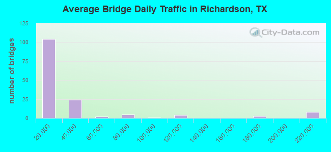
- 4,484,097Total average daily traffic
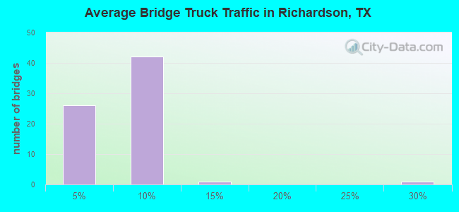
- 200,142Total average daily truck traffic
- National Bridge Inventory (NBI) Registered Bridges for Richardson
- No street view available for this location
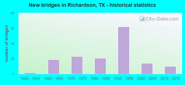
- New bridges - historical statistics
- 21950-1959
- 191960-1969
- 231970-1979
- 211980-1989
- 621990-1999
- 142000-2009
- 102010-2019
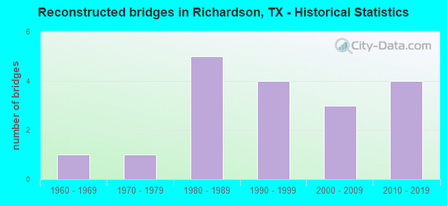
- Reconstructed bridges - Historical Statistics
- 11960-1969
- 11970-1979
- 51980-1989
- 41990-1999
- 32000-2009
- 42010-2019
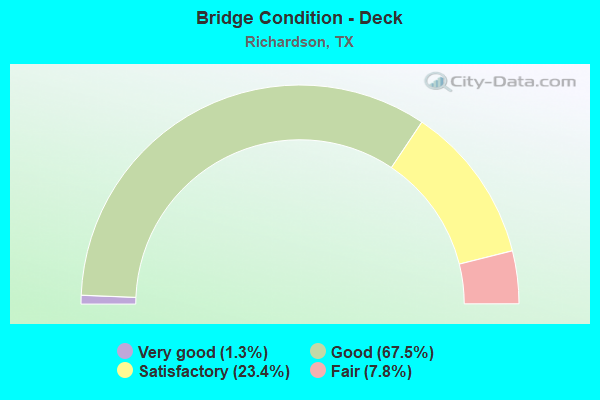
- Bridge Condition - Deck
- 1.3%Very good
- 67.5%Good
- 23.4%Satisfactory
- 7.8%Fair
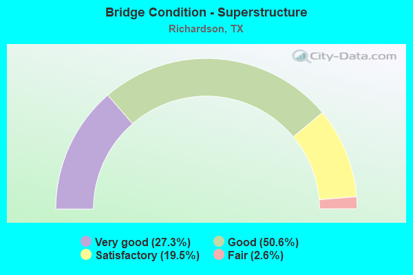
- Bridge Condition - Superstructure
- 27.3%Very good
- 50.6%Good
- 19.5%Satisfactory
- 2.6%Fair
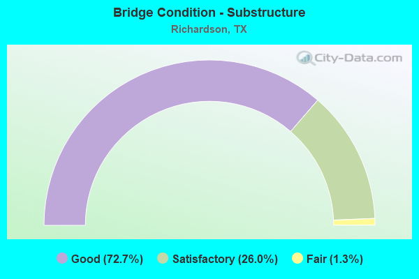
- Bridge Condition - Substructure
- 72.7%Good
- 26.0%Satisfactory
- 1.3%Fair
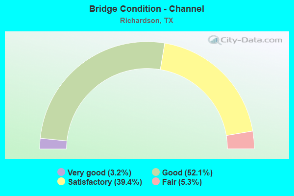
- Bridge Condition - Channel
- 3.2%Very good
- 52.1%Good
- 39.4%Satisfactory
- 5.3%Fair
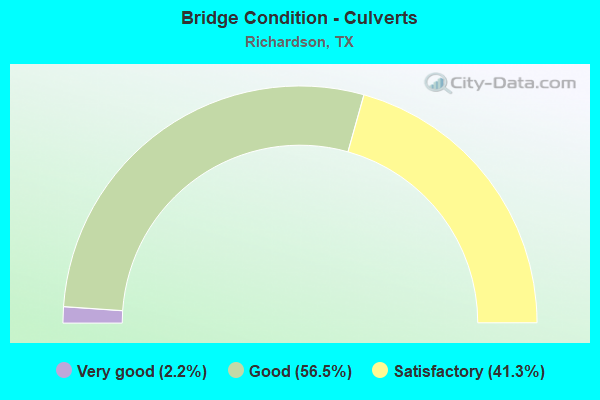
- Bridge Condition - Culverts
- 2.2%Very good
- 56.5%Good
- 41.3%Satisfactory
Find on map >> Show street view
Structure Number: 180570E02905012, Location: 0.6 MI W od US 75 (Lat: 32.940061, Lng: -96.756489), Route carried "on" structure: City street , Year Built: 2019, Status: Open, Structure Length: 3.60m (11.81ft), Average Daily Traffic: 32,302 (year 2014), Average Future Daily Traffic: 35,000 (year 2020), Design Load: HL 93, Features Intersected: Cottonwood Creek, Facility Carried by Structure: Spring Valley Ed.
Minimum Vertical Clearance: 30+ m (98+ ft), Kilometerpoint: 24.317, Lanes on structure: 6, Owner: City or Municipal Highway Agency, Approaching Roadway Width: 10.1m (33.1ft), Skew: 20 degrees, Material/Design: Prestressed concrete, Design/Construction: Stringer/Multi-beam, Number Of Spans In Main Unit: 1, Length of Maximum Span: 36.0m (118.1ft), Curb or Sidewalk Widths: Left: 3.2m (10.5ft), Right: 1.4m (4.6ft), Curb-To-Curb Width: 20.4m (66.9ft), Out-to-Out Width: 31.1m (102.0ft)
Condition: Deck: Good, Superstructure: Good, Substructure: Good, Channel: Good, Operating Rating: 54.4 metric tons, Method Used To Determine Operating Rating: Assigned ratings based on Load and Resistance Factor Design (LRFD) reported in metric tons, Inventory Rating: 32.7 metric tons, Method Used To Determine Inventory Rating: Assigned ratings based on Load and Resistance Factor Design (LRFD) reported in metric tons, Structural Evaluation: Better than present minimum criteria, Deck Geometry: High priority of replacement, Waterway Adequacy: Superior to present desirable criteria, Approach Roadway Alignment: Equal to present desirable criteria, Designated Inspection Frequency: Every 24 months, Inspection Date: April 2021, Deck Structure Type: Concrete Cast-file-Place
Find on map >> Show street view
Structure Number: 180570E02905017, Location: 0.10 MI W OF GREENVILLE A (Lat: 32.942900, Lng: -96.734756), Route carried "on" structure: City street , Year Built: 2010, Status: Open, Structure Length: 2.10m (6.89ft), Average Daily Traffic: 100 (year 2017), Truck Traffic: 1%, Average Future Daily Traffic: 120 (year 2037), Features Intersected: FLOYD BRANCH, Facility Carried by Structure: BRICK ROW DR
Minimum Vertical Clearance: 30+ m (98+ ft), Kilometerpoint: 0.000, Lanes on structure: 2, Owner: City or Municipal Highway Agency, Approaching Roadway Width: 7.3m (24.0ft), Material/Design: Prestressed concrete, Design/Construction: Stringer/Multi-beam, Number Of Spans In Main Unit: 1, Length of Maximum Span: 21.0m (68.9ft), Curb or Sidewalk Widths: Left: 2.1m (6.9ft), Right: 2.1m (6.9ft), Curb-To-Curb Width: 7.3m (24.0ft), Out-to-Out Width: 12.1m (39.7ft)
Condition: Deck: Good, Superstructure: Very good, Substructure: Good, Channel: Good, Operating Rating: 32.7 metric tons, Method Used To Determine Operating Rating: Field evaluation and documented engineering judgment, Inventory Rating: 24.5 metric tons, Method Used To Determine Inventory Rating: Field evaluation and documented engineering judgment, Structural Evaluation: Equal to present minimum criteria, Deck Geometry: Equal to present minimum criteria, Waterway Adequacy: Better than present minimum criteria, Approach Roadway Alignment: Equal to present desirable criteria, Designated Inspection Frequency: Every 24 months, Inspection Date: January 2021, Deck Structure Type: Concrete Cast-file-Place
Find on map >> Show street view
Structure Number: 180570LT6044001, Location: 0.05 Mi E of Waterview Pk (Lat: 32.985708, Lng: -96.755414), Route carried "on" structure: City street , Year Built: 2016, Status: Open, Structure Length: 0.67m (2.20ft), Average Daily Traffic: 2,000 (year 2021), Truck Traffic: 3%, Average Future Daily Traffic: 3,000 (year 2041), Design Load: HL 93, Features Intersected: W Fk Cottonwood Crk, Facility Carried by Structure: Frankyln Jenifer
Minimum Vertical Clearance: 30+ m (98+ ft), Kilometerpoint: 0.080, Lanes on structure: 3, Owner: City or Municipal Highway Agency, Approaching Roadway Width: 11.0m (36.1ft), Skew: 3 degrees, Material/Design: Concrete, Design/Construction: Culvert, Number Of Spans In Main Unit: 2, Length of Maximum Span: 2.4m (7.9ft), Curb or Sidewalk Widths: Left: 2.7m (8.9ft), Right: 0.0m, Curb-To-Curb Width: 10.8m (35.4ft), Out-to-Out Width: 17.1m (56.1ft)
Condition: Channel: Good, Culverts: Good, Operating Rating: 54.4 metric tons, Method Used To Determine Operating Rating: Assigned ratings based on Load and Resistance Factor Design (LRFD) reported in metric tons, Inventory Rating: 32.7 metric tons, Method Used To Determine Inventory Rating: Assigned ratings based on Load and Resistance Factor Design (LRFD) reported in metric tons, Structural Evaluation: Better than present minimum criteria, Deck Geometry: High priority of replacement, Waterway Adequacy: Better than present minimum criteria, Approach Roadway Alignment: Equal to present desirable criteria, Designated Inspection Frequency: Every 24 months, Inspection Date: June 2021, Deck Structure Type: Concrete Precast Panels, Wearing Surface/Protective System: Wearing Surface: Monolithic Concrete
Find on map >> Show street view
Structure Number: 180430004706344, Location: 0.45 MI S OF G BUSH TPKE (Lat: 32.997303, Lng: -96.709239), Route carried "under" structure: Alternate City street , Year Built: 1992, Structure Length: 0. m, Average Daily Traffic: 11,484 (year 2019), Truck Traffic: 3%, Features Intersected: RENNER RD, Facility Carried by Structure: US 75
Minimum Vertical Clearance: 5.13m (16.83ft), Kilometerpoint: 7.918, Lanes on structure: 12, Lanes under structure: 10, Material/Design: Prestressed concrete, Design/Construction: Stringer/Multi-beam, Length of Maximum Span: 39.0m (128.0ft)
Structure Number: 180430296405311, Location: 6.5 MI N OF IH 635, Route carried "under" structure: US 75, Year Built: 1998, Structure Length: 0. m, Average Daily Traffic: 164,300 (year 2010), Truck Traffic: 9%, Features Intersected: US 75/DART RR/SPRING CRK, Facility Carried by Structure: SH 190 EB ML
Minimum Vertical Clearance: 5.31m (17.42ft), Kilometerpoint: 21.445, Material/Design: Steel, Design/Construction: Stringer/Multi-beam, Length of Maximum Span: 53.3m (174.9ft)
Minimum Vertical Clearance: 5.31m (17.42ft), Kilometerpoint: 21.445, Material/Design: Steel, Design/Construction: Stringer/Multi-beam, Length of Maximum Span: 53.3m (174.9ft)
Structure Number: 180430296405315, Location: US 75 @ SH 190, Route carried "under" structure: US 75, Year Built: 1998, Structure Length: 0. m, Average Daily Traffic: 34,255 (year 2010), Truck Traffic: 9%, Features Intersected: US 75 / CONN J & K, Facility Carried by Structure: SH 190 CONN H
Minimum Vertical Clearance: 5.49m (18.01ft), Kilometerpoint: 15.731, Material/Design: Steel continuous, Design/Construction: Stringer/Multi-beam, Length of Maximum Span: 69.2m (227.0ft)
Minimum Vertical Clearance: 5.49m (18.01ft), Kilometerpoint: 15.731, Material/Design: Steel continuous, Design/Construction: Stringer/Multi-beam, Length of Maximum Span: 69.2m (227.0ft)
Structure Number: 180430296405317, Location: US 75 @ SH 190, Route carried "under" structure: US 75, Year Built: 1998, Structure Length: 0. m, Average Daily Traffic: 34,255 (year 2010), Truck Traffic: 9%, Features Intersected: US 75, Facility Carried by Structure: SH 190 CONN J
Minimum Vertical Clearance: 5.39m (17.68ft), Kilometerpoint: 15.731, Material/Design: Steel continuous, Design/Construction: Stringer/Multi-beam, Length of Maximum Span: 51.8m (169.9ft)
Minimum Vertical Clearance: 5.39m (17.68ft), Kilometerpoint: 15.731, Material/Design: Steel continuous, Design/Construction: Stringer/Multi-beam, Length of Maximum Span: 51.8m (169.9ft)
Structure Number: 180430296405321, Location: US 75 @ SH 190, Route carried "under" structure: ServiceUS 75, Year Built: 1998, Structure Length: 0. m, Average Daily Traffic: 16,430 (year 2010), Truck Traffic: 6%, Features Intersected: US 75 NBFR / CRAWFORD ST, Facility Carried by Structure: SH 190 CONN N
Minimum Vertical Clearance: 8.23m (27.00ft), Kilometerpoint: 15.731, Material/Design: Steel continuous, Design/Construction: Stringer/Multi-beam, Length of Maximum Span: 50.3m (165.0ft)
Minimum Vertical Clearance: 8.23m (27.00ft), Kilometerpoint: 15.731, Material/Design: Steel continuous, Design/Construction: Stringer/Multi-beam, Length of Maximum Span: 50.3m (165.0ft)
Structure Number: 180430296405322, Location: US 75 @ SH 190, Route carried "under" structure: ServiceUS 75, Year Built: 1998, Structure Length: 0. m, Average Daily Traffic: 16,430 (year 2010), Truck Traffic: 6%, Features Intersected: US 75 SBFR / SPRING CRK, Facility Carried by Structure: SH 190 CONN 'O'
Minimum Vertical Clearance: 6.30m (20.67ft), Kilometerpoint: 15.731, Material/Design: Steel continuous, Design/Construction: Stringer/Multi-beam, Length of Maximum Span: 47.2m (154.9ft)
Minimum Vertical Clearance: 6.30m (20.67ft), Kilometerpoint: 15.731, Material/Design: Steel continuous, Design/Construction: Stringer/Multi-beam, Length of Maximum Span: 47.2m (154.9ft)
Structure Number: 180430296405325, Location: US 75 @ SH 190, Route carried "under" structure: City street , Year Built: 1998, Structure Length: 0. m, Average Daily Traffic: 15,000 (year 2010), Truck Traffic: 1%, Features Intersected: RENNER RD, Facility Carried by Structure: US 75 NB OFF RP Q
Minimum Vertical Clearance: 6.04m (19.82ft), Kilometerpoint: 18.461, Material/Design: Prestressed concrete, Design/Construction: Stringer/Multi-beam, Length of Maximum Span: 38.7m (127.0ft)
Minimum Vertical Clearance: 6.04m (19.82ft), Kilometerpoint: 18.461, Material/Design: Prestressed concrete, Design/Construction: Stringer/Multi-beam, Length of Maximum Span: 38.7m (127.0ft)
Structure Number: 180430296405326, Location: US 75 @ SH 190, Route carried "under" structure: City street , Year Built: 1998, Structure Length: 0. m, Average Daily Traffic: 15,000 (year 2010), Truck Traffic: 1%, Features Intersected: RENNER ROAD & SPRING CK, Facility Carried by Structure: US 75 SB ON RP U
Minimum Vertical Clearance: 5.66m (18.57ft), Kilometerpoint: 22.223, Material/Design: Prestressed concrete, Design/Construction: Stringer/Multi-beam, Length of Maximum Span: 38.7m (127.0ft)
Minimum Vertical Clearance: 5.66m (18.57ft), Kilometerpoint: 22.223, Material/Design: Prestressed concrete, Design/Construction: Stringer/Multi-beam, Length of Maximum Span: 38.7m (127.0ft)
Find on map >> Show street view
Structure Number: 180430296405554, Location: SH 190 @ Custer Pkwy. (Lat: 33.003669, Lng: -96.731883), Route carried "under" structure: City street , Year Built: 1999, Structure Length: 0. m, Average Daily Traffic: 12,112 (year 2011), Truck Traffic: 3%, Features Intersected: CUSTER PKWY, Facility Carried by Structure: PGBT EB
Minimum Vertical Clearance: 5.41m (17.75ft), Kilometerpoint: 13.517, Lanes on structure: 5, Lanes under structure: 8, Material/Design: Prestressed concrete continuous, Design/Construction: Stringer/Multi-beam, Length of Maximum Span: 41.8m (137.1ft)
Find on map >> Show street view
Structure Number: 180430296405556, Location: 1.5 MI E OF US 75 (Lat: 33.002311, Lng: -96.682275), Route carried "under" structure: City street , Year Built: 1996, Structure Length: 0. m, Average Daily Traffic: 24,310 (year 2018), Truck Traffic: 3%, Features Intersected: JUPITER RD, Facility Carried by Structure: PGBT EB
Minimum Vertical Clearance: 5.49m (18.01ft), Kilometerpoint: 13.747, Lanes on structure: 5, Lanes under structure: 8, Material/Design: Prestressed concrete, Design/Construction: Stringer/Multi-beam, Length of Maximum Span: 32.3m (106.0ft)
Find on map >> Show street view
Structure Number: 180430296405557, Location: SH 190 @ Renner Rd. (Lat: 32.997106, Lng: -96.670569), Route carried "under" structure: City street , Year Built: 1999, Structure Length: 0. m, Average Daily Traffic: 37,785 (year 2018), Truck Traffic: 3%, Features Intersected: RENNER RD, Facility Carried by Structure: PGBT WB
Minimum Vertical Clearance: 5.79m (19.00ft), Kilometerpoint: 15.286, Lanes on structure: 5, Lanes under structure: 8, Material/Design: Prestressed concrete, Design/Construction: Stringer/Multi-beam, Length of Maximum Span: 39.6m (129.9ft)
Find on map >> Show street view
Structure Number: 180430296405558, Location: SH 190 @ Renner Road (Lat: 32.997122, Lng: -96.671239), Route carried "under" structure: City street , Year Built: 1999, Structure Length: 0. m, Average Daily Traffic: 23,344 (year 2018), Truck Traffic: 3%, Features Intersected: RENNER RD, Facility Carried by Structure: PGBT EB
Minimum Vertical Clearance: 5.66m (18.57ft), Kilometerpoint: 15.286, Lanes on structure: 5, Lanes under structure: 8, Material/Design: Prestressed concrete, Design/Construction: Stringer/Multi-beam, Length of Maximum Span: 39.6m (129.9ft)
Find on map >> Show street view
Structure Number: 180430296405559, Location: SH 190 @ SHiloh Rd. (Lat: 32.986186, Lng: -96.666528), Route carried "under" structure: City street , Year Built: 1996, Structure Length: 0. m, Average Daily Traffic: 4,000 (year 2011), Features Intersected: SHILOH RD SB, Facility Carried by Structure: PGBT SB
Minimum Vertical Clearance: 6.78m (22.24ft), Kilometerpoint: 16.612, Lanes on structure: 4, Lanes under structure: 1, Material/Design: Prestressed concrete, Design/Construction: Stringer/Multi-beam, Length of Maximum Span: 35.7m (117.1ft)
Find on map >> Show street view
Structure Number: 18043029640556, Location: SH 190 @ Shiloh Rd. (Lat: 32.986856, Lng: -96.666100), Route carried "under" structure: City street , Year Built: 1999, Structure Length: 0. m, Average Daily Traffic: 4,000 (year 2011), Features Intersected: SHILOH RD SB, Facility Carried by Structure: PGBT NB
Minimum Vertical Clearance: 6.76m (22.18ft), Kilometerpoint: 16.790, Lanes on structure: 3, Lanes under structure: 2, Material/Design: Prestressed concrete, Design/Construction: Stringer/Multi-beam, Length of Maximum Span: 35.7m (117.1ft)
Find on map >> Show street view
Structure Number: 180430296405561, Location: SH 190 @ Shiloh Rd. (Lat: 32.986206, Lng: -96.666753), Route carried "under" structure: City street , Year Built: 1996, Structure Length: 0. m, Average Daily Traffic: 4,000 (year 2011), Features Intersected: SHILOH RD SB, Facility Carried by Structure: PGBT SB Ramp
Minimum Vertical Clearance: 5.23m (17.16ft), Kilometerpoint: 16.790, Lanes on structure: 1, Lanes under structure: 1, Material/Design: Prestressed concrete, Design/Construction: Stringer/Multi-beam, Length of Maximum Span: 27.0m (88.6ft)
Find on map >> Show street view
Structure Number: 180430296405562, Location: SH 190 @ Shiloh Rd. (Lat: 32.986897, Lng: -96.665958), Route carried "under" structure: City street , Year Built: 1996, Structure Length: 0. m, Average Daily Traffic: 4,000 (year 2011), Features Intersected: SHILOH RD SB, Facility Carried by Structure: PGBT NB Ramp
Minimum Vertical Clearance: 5.18m (16.99ft), Kilometerpoint: 16.792, Lanes on structure: 1, Lanes under structure: 2, Material/Design: Prestressed concrete, Design/Construction: Stringer/Multi-beam, Length of Maximum Span: 26.8m (87.9ft)
Find on map >> Show street view
Structure Number: 180570004707271, Location: 1.75 MI NE OF IH 635 (Lat: 32.939744, Lng: -96.745700), Route carried "under" structure: City street , Year Built: 1988, Structure Length: 0. m, Average Daily Traffic: 20,000 (year 2016), Features Intersected: SPRING VALLEY RD, Facility Carried by Structure: US 75 NB
Minimum Vertical Clearance: 5.28m (17.32ft), Kilometerpoint: 0.805, Lanes on structure: 8, Material/Design: Prestressed concrete continuous, Design/Construction: Stringer/Multi-beam, Length of Maximum Span: 36.6m (120.1ft)
Find on map >> Show street view
Structure Number: 180570004707275, Location: 2.85 MI NE OF IH 635 (Lat: 32.950700, Lng: -96.734342), Route carried "under" structure: City street 50, Year Built: 1988, Structure Length: 0. m, Average Daily Traffic: 29,970 (year 2016), Features Intersected: BELT LINE RD, Facility Carried by Structure: US 75 NB
Minimum Vertical Clearance: 5.39m (17.68ft), Kilometerpoint: 7.469, Lanes on structure: 10, Material/Design: Prestressed concrete, Design/Construction: Stringer/Multi-beam, Length of Maximum Span: 32.0m (105.0ft)
Find on map >> Show street view
Structure Number: 180570004707278, Location: 3.80 MI NE OF IH 635 (Lat: 32.960797, Lng: -96.727958), Route carried "under" structure: Alternate City street , Year Built: 1990, Structure Length: 0. m, Average Daily Traffic: 2,178 (year 2013), Features Intersected: ARAPAHO RD, Facility Carried by Structure: US 75 SB
Minimum Vertical Clearance: 5.21m (17.09ft), Kilometerpoint: 34.990, Lanes on structure: 10, Material/Design: Prestressed concrete, Design/Construction: Stringer/Multi-beam, Length of Maximum Span: 42.1m (138.1ft)
Find on map >> Show street view
Structure Number: 18057000470728, Location: 5.20 MI NE OF IH 635 (Lat: 32.975525, Lng: -96.716342), Route carried "under" structure: Alternate City street , Year Built: 1990, Structure Length: 0. m, Average Daily Traffic: 2,114 (year 2016), Features Intersected: CAMPBELL RD, Facility Carried by Structure: US 75 SB
Minimum Vertical Clearance: 5.56m (18.24ft), Kilometerpoint: 75.916, Lanes on structure: 10, Material/Design: Prestressed concrete, Design/Construction: Stringer/Multi-beam, Length of Maximum Span: 38.4m (126.0ft)
Find on map >> Show street view
Structure Number: 180570004707287, Location: 3.80 MI NE OF IH 635 (Lat: 32.961114, Lng: -96.726872), Route carried "under" structure: Alternate City street , Year Built: 1990, Structure Length: 0. m, Average Daily Traffic: 2,178 (year 2016), Features Intersected: ARAPAHO RD, Facility Carried by Structure: US 75 NB
Minimum Vertical Clearance: 5.21m (17.09ft), Kilometerpoint: 34.990, Lanes on structure: 10, Material/Design: Prestressed concrete, Design/Construction: Stringer/Multi-beam, Length of Maximum Span: 42.4m (139.1ft)
Find on map >> Show street view
Structure Number: 180570004707288, Location: 5.20 MI NE OF IH 635 (Lat: 32.975808, Lng: -96.715611), Route carried "under" structure: Alternate City street , Year Built: 1990, Structure Length: 0. m, Average Daily Traffic: 2,114 (year 2016), Features Intersected: CAMPBELL RD, Facility Carried by Structure: US 75 NB
Minimum Vertical Clearance: 5.87m (19.26ft), Kilometerpoint: 75.916, Lanes on structure: 10, Material/Design: Prestressed concrete, Design/Construction: Stringer/Multi-beam, Length of Maximum Span: 38.7m (127.0ft)
Find on map >> Show street view
Structure Number: 180570004707289, Location: 4.45 MI NE OF IH 635 (Lat: 32.967642, Lng: -96.720406), Route carried "under" structure: US 75, Year Built: 1985, Structure Length: 0. m, Average Daily Traffic: 219,750 (year 2013), Truck Traffic: 6%, Features Intersected: US 75 & DART RAIL, Facility Carried by Structure: COLLINS BLVD
Minimum Vertical Clearance: 8.74m (28.67ft), Kilometerpoint: 1.914, Lanes on structure: 24, Material/Design: Prestressed concrete, Design/Construction: Stringer/Multi-beam, Length of Maximum Span: 35.1m (115.2ft)
Find on map >> Show street view
Structure Number: 180570004707293, Location: 1.75 MI NE OF IH 635 (Lat: 32.939753, Lng: -96.746469), Route carried "under" structure: City street , Year Built: 1988, Structure Length: 0. m, Average Daily Traffic: 20,000 (year 2016), Features Intersected: SPRING VALLEY RD, Facility Carried by Structure: US 75 SB
Minimum Vertical Clearance: 5.28m (17.32ft), Kilometerpoint: 0.805, Lanes on structure: 8, Material/Design: Prestressed concrete continuous, Design/Construction: Stringer/Multi-beam, Length of Maximum Span: 36.6m (120.1ft)
Find on map >> Show street view
Structure Number: 180570004707294, Location: 2.85 MI NE OF IH 635 (Lat: 32.950747, Lng: -96.734875), Route carried "under" structure: City street 50, Year Built: 1988, Structure Length: 0. m, Average Daily Traffic: 29,970 (year 2016), Features Intersected: BELT LINE RD, Facility Carried by Structure: US 75 SB
Minimum Vertical Clearance: 5.39m (17.68ft), Kilometerpoint: 7.469, Lanes on structure: 10, Material/Design: Prestressed concrete, Design/Construction: Stringer/Multi-beam, Length of Maximum Span: 32.0m (105.0ft)
Find on map >> Show street view
Structure Number: 180570004707416, Location: 0.10 MILES S OF COLLIN CL (Lat: 32.982361, Lng: -96.712514), Route carried "under" structure: ServiceUS 75, Year Built: 2004, Structure Length: 0. m, Average Daily Traffic: 15,000 (year 2016), Truck Traffic: 5%, Features Intersected: US 75 NB FR
Minimum Vertical Clearance: 6.35m (20.83ft), Kilometerpoint: 2.791, Lanes on structure: 3, Material/Design: Concrete, Design/Construction: Box Beam or Girders - Single/Spread, Length of Maximum Span: 41.1m (134.8ft)
Find on map >> Show street view
Structure Number: 180570004707417, Location: 0.10 MILES S OF COLLIN CL (Lat: 32.983208, Lng: -96.712303), Route carried "under" structure: US 75, Year Built: 2004, Structure Length: 0. m, Average Daily Traffic: 175,000 (year 2016), Truck Traffic: 5%, Features Intersected: US 75, Facility Carried by Structure: GALATYN CROSSING
Minimum Vertical Clearance: 6.02m (19.75ft), Kilometerpoint: 2.791, Lanes on structure: 10, Material/Design: Prestressed concrete, Design/Construction: Stringer/Multi-beam, Length of Maximum Span: 36.6m (120.1ft)
Find on map >> Show street view
Structure Number: 180570004707419, Location: US 75 @ SPRING VALLEY RD (Lat: 32.940003, Lng: -96.746664), Route carried "under" structure: City street , Year Built: 2004, Structure Length: 0. m, Average Daily Traffic: 20,000 (year 2016), Truck Traffic: 5%, Features Intersected: SPRING VALLEY ROAD, Facility Carried by Structure: US 75 NB & SB FR
Minimum Vertical Clearance: 5.46m (17.91ft), Kilometerpoint: 3.500, Lanes on structure: 4, Material/Design: Prestressed concrete, Design/Construction: Box Beam or Girders - Multiple, Length of Maximum Span: 17.4m (57.1ft)