Bridge Statistics for San Bernardino, California (CA)
Condition, Traffic, Stress, Structural Evaluation, Project Costs
- National Bridge Inventory (NBI) Statistics
- 339Number of bridges
- 5,141ft / 1,567mTotal length
- $23,924,000Total costs
- 11,722,332Total average daily traffic
- 875,180Total average daily truck traffic
- National Bridge Inventory (NBI) Registered Bridges for San Bernardino
- No street view available for this location

- New bridges - historical statistics
- 21930-1939
- 111940-1949
- 311950-1959
- 931960-1969
- 341970-1979
- 341980-1989
- 281990-1999
- 272000-2009
- 792010-2019
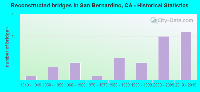
- Reconstructed bridges - Historical Statistics
- 11940-1949
- 31950-1959
- 41960-1969
- 11970-1979
- 51980-1989
- 41990-1999
- 102000-2009
- 112010-2019
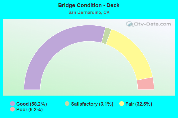
- Bridge Condition - Deck
- 58.2%Good
- 3.1%Satisfactory
- 32.5%Fair
- 6.2%Poor
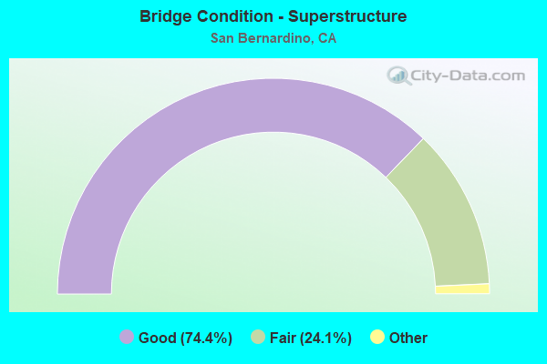
- Bridge Condition - Superstructure
- 74.4%Very good
- 24.1%Good
- 1.5%Satisfactory
- 24.1%Fair
- 0.5%Poor
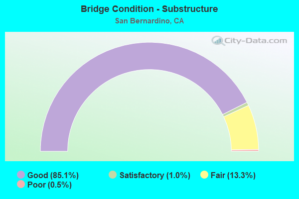
- Bridge Condition - Substructure
- 85.1%Good
- 1.0%Satisfactory
- 13.3%Fair
- 0.5%Poor
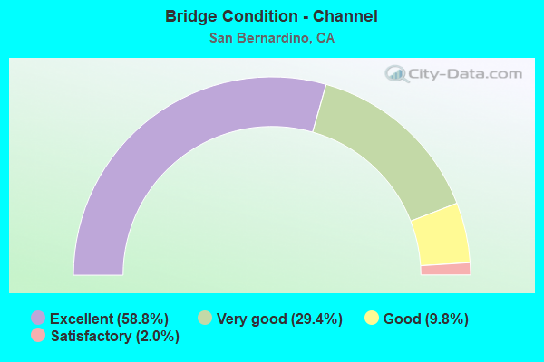
- Bridge Condition - Channel
- 58.8%Excellent
- 29.4%Very good
- 9.8%Good
- 2.0%Satisfactory
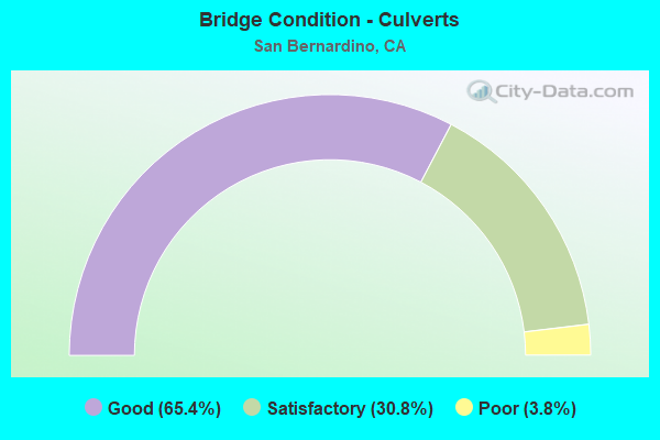
- Bridge Condition - Culverts
- 65.4%Good
- 30.8%Satisfactory
- 3.8%Poor
Find on map >> Show street view
Structure Number: 54 0030L, Location: 08-SBD-010-11.50 (Lat: 34.067769, Lng: -117.517056), Route carried "on" structure: Interstate 10, Year Built: 1947, Year Reconstructed: 1966, Status: Open, Structure Length: 3.47m (11.38ft), Average Daily Traffic: 125,000 (year 2019), Truck Traffic: 10%, Average Future Daily Traffic: 150,000 (year 2041), Design Load: HS 20, Features Intersected: E10-VALLEY BLVD OFF-RAMP
Minimum Vertical Clearance: 30+ m (98+ ft), Kilometerpoint: 11.500, Lanes on structure: 4, Lanes under structure: 1, Base Highway Network: Yes (, Subroute: 1), Owner: State Highway Agency, Approaching Roadway Width: 20.1m (65.9ft), Skew: 5 degrees, Material/Design: Steel continuous, Design/Construction: Stringer/Multi-beam, Number Of Spans In Main Unit: 3, Length of Maximum Span: 15.5m (50.9ft), Curb-To-Curb Width: 20.1m (65.9ft), Out-to-Out Width: 20.7m (67.9ft)
Condition: Deck: Fair, Superstructure: Good, Substructure: Good, Operating Rating: 63.8 metric tons, Method Used To Determine Operating Rating: Load Factor (LF), Inventory Rating: 38.2 metric tons, Method Used To Determine Inventory Rating: Load Factor (LF), Structural Evaluation: Better than present minimum criteria, Deck Geometry: Equal to present minimum criteria, Underclear: Equal to present minimum criteria, Approach Roadway Alignment: Equal to present desirable criteria, Designated Inspection Frequency: Every 24 months, Inspection Date: June 2021, Deck Structure Type: Concrete Cast-file-Place
Find on map >> Show street view
Structure Number: 54 0035, Location: 08-SBD-010-R18.49-SBD (Lat: 34.068839, Lng: -117.396247), Route carried "on" structure: City street R047, Year Built: 1967, Status: Open, Structure Length: 8.20m (26.90ft), Average Daily Traffic: 35,000 (year 2017), Truck Traffic: 6%, Average Future Daily Traffic: 45,000 (year 2039), Design Load: HS 20+Mod, Features Intersected: INTERSTATE 10, Facility Carried by Structure: CEDAR AVENUE
Minimum Vertical Clearance: 30+ m (98+ ft), Kilometerpoint: 0.000, Lanes on structure: 6, Lanes under structure: 8, Owner: State Highway Agency, Approaching Roadway Width: 25.0m (82.0ft), Material/Design: Steel continuous, Design/Construction: Stringer/Multi-beam, Number Of Spans In Main Unit: 2, Length of Maximum Span: 43.3m (142.1ft), Curb or Sidewalk Widths: Left: 1.5m (4.9ft), Right: 1.5m (4.9ft), Curb-To-Curb Width: 25.0m (82.0ft), Out-to-Out Width: 28.7m (94.2ft)
Condition: Deck: Good, Superstructure: Good, Substructure: Good, Operating Rating: 44.4 metric tons, Method Used To Determine Operating Rating: Load Factor (LF), Inventory Rating: 26.6 metric tons, Method Used To Determine Inventory Rating: Load Factor (LF), Structural Evaluation: Equal to present minimum criteria, Deck Geometry: Somewhat better than minimum adequacy, Underclear: Meets minimum limits, Approach Roadway Alignment: Equal to present desirable criteria, Designated Inspection Frequency: Every 24 months, Other Special Inspection Frequency: Every 48 months, Inspection Date: April 2020, Other Special Inspection Date: September 2019, Deck Structure Type: Concrete Cast-file-Place, Wearing Surface/Protective System: Wearing Surface: Bituminous
Find on map >> Show street view
Structure Number: 54 0264L, Location: 08-SBD-210-20.69-SBD (Lat: 34.134586, Lng: -117.335731), Route carried "on" structure: State highway 210, Year Built: 2007, Status: Open, Structure Length: 4.92m (16.14ft), Average Daily Traffic: 78,000 (year 2019), Truck Traffic: 6%, Average Future Daily Traffic: 85,000 (year 2040), Design Load: HS 20+Mod, Features Intersected: STATE STREET
Minimum Vertical Clearance: 30+ m (98+ ft), Kilometerpoint: 20.690, Lanes on structure: 4, Lanes under structure: 6, Base Highway Network: Yes (Inventory Route: 2, Subroute: 1), Owner: State Highway Agency, Approaching Roadway Width: 22.4m (73.5ft), Material/Design: Prestressed concrete, Design/Construction: Box Beam or Girders - Multiple, Number Of Spans In Main Unit: 1, Length of Maximum Span: 49.2m (161.4ft), Curb-To-Curb Width: 21.6m (70.9ft), Out-to-Out Width: 22.4m (73.5ft)
Condition: Deck: Good, Superstructure: Good, Substructure: Good, Operating Rating: 54.1 metric tons, Method Used To Determine Operating Rating: Assigned rating based on Load Factor Design (LFD) reported in metric tons, Inventory Rating: 32.4 metric tons, Method Used To Determine Inventory Rating: Assigned rating based on Load Factor Design (LFD) reported in metric tons, Structural Evaluation: Better than present minimum criteria, Deck Geometry: Better than present minimum criteria, Underclear: Equal to present minimum criteria, Approach Roadway Alignment: Equal to present desirable criteria, Designated Inspection Frequency: Every 24 months, Inspection Date: December 2021, Deck Structure Type: Concrete Cast-file-Place
Find on map >> Show street view
Structure Number: 54 0264R, Location: 08-SBD-210-20.69-SBD (Lat: 34.134322, Lng: -117.335731), Route carried "on" structure: State highway 210, Year Built: 2007, Status: Open, Structure Length: 4.92m (16.14ft), Average Daily Traffic: 78,000 (year 2019), Truck Traffic: 6%, Average Future Daily Traffic: 85,000 (year 2040), Design Load: HS 20+Mod, Features Intersected: STATE STREET
Minimum Vertical Clearance: 30+ m (98+ ft), Kilometerpoint: 20.690, Lanes on structure: 4, Lanes under structure: 6, Base Highway Network: Yes, Owner: State Highway Agency, Approaching Roadway Width: 22.4m (73.5ft), Material/Design: Prestressed concrete, Design/Construction: Box Beam or Girders - Multiple, Number Of Spans In Main Unit: 1, Length of Maximum Span: 49.2m (161.4ft), Curb-To-Curb Width: 21.6m (70.9ft), Out-to-Out Width: 22.4m (73.5ft)
Condition: Deck: Good, Superstructure: Good, Substructure: Good, Operating Rating: 54.1 metric tons, Method Used To Determine Operating Rating: Assigned rating based on Load Factor Design (LFD) reported in metric tons, Inventory Rating: 32.4 metric tons, Method Used To Determine Inventory Rating: Assigned rating based on Load Factor Design (LFD) reported in metric tons, Structural Evaluation: Better than present minimum criteria, Deck Geometry: Better than present minimum criteria, Underclear: Equal to present minimum criteria, Approach Roadway Alignment: Equal to present desirable criteria, Designated Inspection Frequency: Every 24 months, Inspection Date: December 2021, Deck Structure Type: Concrete Cast-file-Place
Find on map >> Show street view
Structure Number: 54 0264S, Location: 08-SBD-210-20.69-SBD (Lat: 34.134111, Lng: -117.335722), Route carried "on" structure: Ramp State highway 210, Year Built: 2007, Status: Open, Structure Length: 5.08m (16.67ft), Average Daily Traffic: 1,001 (year 2017), Truck Traffic: 4%, Average Future Daily Traffic: 1,530 (year 2041), Design Load: HS 20+Mod, Features Intersected: STATE STREET
Minimum Vertical Clearance: 30+ m (98+ ft), Kilometerpoint: 20.690, Lanes on structure: 1, Lanes under structure: 4, Owner: State Highway Agency, Approaching Roadway Width: 8.5m (27.9ft), Material/Design: Prestressed concrete, Design/Construction: Box Beam or Girders - Multiple, Number Of Spans In Main Unit: 1, Length of Maximum Span: 50.8m (166.7ft), Curb-To-Curb Width: 8.3m (27.2ft), Out-to-Out Width: 9.2m (30.2ft)
Condition: Deck: Good, Superstructure: Good, Substructure: Good, Operating Rating: 54.1 metric tons, Method Used To Determine Operating Rating: Assigned rating based on Load Factor Design (LFD) reported in metric tons, Inventory Rating: 32.4 metric tons, Method Used To Determine Inventory Rating: Assigned rating based on Load Factor Design (LFD) reported in metric tons, Structural Evaluation: Better than present minimum criteria, Deck Geometry: Superior to present desirable criteria, Underclear: Equal to present minimum criteria, Approach Roadway Alignment: Equal to present desirable criteria, Designated Inspection Frequency: Every 24 months, Inspection Date: December 2021, Deck Structure Type: Concrete Cast-file-Place
Find on map >> Show street view
Structure Number: 54 0365, Location: 08-SBD-330-32.51 (Lat: 34.172878, Lng: -117.182031), Route carried "on" structure: State highway 330, Year Built: 1947, Status: Open, Structure Length: 13.11m (43.01ft), Average Daily Traffic: 11,000 (year 2017), Truck Traffic: 3%, Average Future Daily Traffic: 15,000 (year 2040), Features Intersected: CITY CREEK
Minimum Vertical Clearance: 30+ m (98+ ft), Kilometerpoint: 32.510, Lanes on structure: 2, Base Highway Network: Yes (Inventory Route: 3, Subroute: 1), Owner: State Highway Agency, Approaching Roadway Width: 8.7m (28.5ft), Material/Design: Concrete, Design/Construction: Arch - Deck, Number Of Spans In Main Unit: 1, Number Of Approach Spans: 13, Length of Maximum Span: 51.8m (169.9ft), Curb-To-Curb Width: 8.7m (28.5ft), Out-to-Out Width: 9.8m (32.2ft)
Condition: Deck: Good, Superstructure: Good, Substructure: Good, Channel: Excellent, Operating Rating: 41.5 metric tons, Method Used To Determine Operating Rating: Load Factor (LF), Inventory Rating: 24.9 metric tons, Method Used To Determine Inventory Rating: Load Factor (LF), Structural Evaluation: Equal to present minimum criteria, Deck Geometry: Meets minimum limits, Waterway Adequacy: Superior to present desirable criteria, Approach Roadway Alignment: Equal to present desirable criteria, Designated Inspection Frequency: Every 24 months, Inspection Date: November 2020, Deck Structure Type: Concrete Cast-file-Place, Wearing Surface/Protective System: Wearing Surface: Bituminous
Find on map >> Show street view
Structure Number: 54 0411, Location: 08-SBD-038-55.99 (Lat: 34.269331, Lng: -116.948017), Route carried "on" structure: State highway 38, Year Built: 1938, Status: Open, Structure Length: 1.34m (4.40ft), Average Daily Traffic: 1,550 (year 2017), Truck Traffic: 10%, Average Future Daily Traffic: 2,600 (year 2040), Features Intersected: GROUT CREEK
Minimum Vertical Clearance: 30+ m (98+ ft), Kilometerpoint: 55.990, Lanes on structure: 2, Base Highway Network: Yes, Owner: State Highway Agency, Approaching Roadway Width: 10.1m (33.1ft), Material/Design: Steel, Design/Construction: Culvert, Number Of Spans In Main Unit: 3, Length of Maximum Span: 4.0m (13.1ft), Curb or Sidewalk Widths: Left: 0.5m (1.6ft), Right: 0.5m (1.6ft), Curb-To-Curb Width: 10.1m (33.1ft), Out-to-Out Width: 12.0m (39.4ft)
Condition: Channel: Very good, Culverts: Satisfactory, Operating Rating: 40.5 metric tons, Method Used To Determine Operating Rating: Field evaluation and documented engineering judgment, Inventory Rating: 24.3 metric tons, Method Used To Determine Inventory Rating: Field evaluation and documented engineering judgment, Structural Evaluation: Equal to present minimum criteria, Deck Geometry: Somewhat better than minimum adequacy, Waterway Adequacy: Equal to present desirable criteria, Approach Roadway Alignment: Better than present minimum criteria, Designated Inspection Frequency: Every 24 months, Inspection Date: November 2020
Find on map >> Show street view
Structure Number: 54 0416, Location: 08-SBD-010-11.74-SBD (Lat: 34.066936, Lng: -117.513639), Route carried "on" structure: Interstate 10, Year Built: 1947, Year Reconstructed: 1978, Status: Open, Structure Length: 0.76m (2.49ft), Average Daily Traffic: 214,000 (year 2018), Truck Traffic: 10%, Average Future Daily Traffic: 225,000 (year 2040), Design Load: HS 20, Features Intersected: UP RR SPUR
Minimum Vertical Clearance: 30+ m (98+ ft), Kilometerpoint: 11.740, Lanes on structure: 9, Base Highway Network: Yes (, Subroute: 1), Owner: State Highway Agency, Approaching Roadway Width: 51.2m (168.0ft), Skew: 31 degrees, Material/Design: Concrete, Design/Construction: Slab, Number Of Spans In Main Unit: 1, Length of Maximum Span: 6.4m (21.0ft), Curb-To-Curb Width: 51.2m (168.0ft), Out-to-Out Width: 52.4m (171.9ft)
Condition: Deck: Fair, Superstructure: Fair, Substructure: Fair, Operating Rating: 40.5 metric tons, Method Used To Determine Operating Rating: Load and Resistance Factor Rating (LRFR) rating reported by rating factor(RF) method using HL-93 loadings, Inventory Rating: 31.1 metric tons, Method Used To Determine Inventory Rating: Load and Resistance Factor Rating (LRFR) rating reported by rating factor(RF) method using HL-93 loadings, Structural Evaluation: Somewhat better than minimum adequacy, Deck Geometry: Superior to present desirable criteria, Underclear: Meets minimum limits, Approach Roadway Alignment: Equal to present desirable criteria, Designated Inspection Frequency: Every 24 months, Inspection Date: April 2020, Deck Structure Type: Concrete Cast-file-Place, Wearing Surface/Protective System: Wearing Surface: Bituminous
Find on map >> Show street view
Structure Number: 54 0422, Location: 08-SBD-210U-20.82-RIA (Lat: 34.135950, Lng: -117.348675), Route carried "on" structure: State highway 210, Year Built: 1967, Status: Open, Structure Length: 10.24m (33.60ft), Average Daily Traffic: 19,800 (year 2016), Truck Traffic: 7%, Average Future Daily Traffic: 25,000 (year 2040), Design Load: HS 20, Features Intersected: LYTLE CREEK
Minimum Vertical Clearance: 30+ m (98+ ft), Kilometerpoint: 20.820, Lanes on structure: 4, Base Highway Network: Yes (Inventory Route: 21, Subroute: 1), Owner: State Highway Agency, Approaching Roadway Width: 19.5m (64.0ft), Skew: 4 degrees, Material/Design: Concrete continuous, Design/Construction: Box Beam or Girders - Multiple, Number Of Spans In Main Unit: 6, Length of Maximum Span: 18.3m (60.0ft), Curb or Sidewalk Widths: Left: 1.5m (4.9ft), Right: 0.0m, Curb-To-Curb Width: 19.5m (64.0ft), Out-to-Out Width: 21.9m (71.9ft)
Condition: Deck: Good, Superstructure: Fair, Substructure: Good, Channel: Very good, Operating Rating: 43.1 metric tons, Method Used To Determine Operating Rating: Load and Resistance Factor Rating (LRFR) rating reported by rating factor(RF) method using HL-93 loadings, Inventory Rating: 33.0 metric tons, Method Used To Determine Inventory Rating: Load and Resistance Factor Rating (LRFR) rating reported by rating factor(RF) method using HL-93 loadings, Structural Evaluation: Somewhat better than minimum adequacy, Deck Geometry: Better than present minimum criteria, Waterway Adequacy: Better than present minimum criteria, Approach Roadway Alignment: Equal to present desirable criteria, Designated Inspection Frequency: Every 24 months, Inspection Date: December 2020, Deck Structure Type: Concrete Cast-file-Place
Find on map >> Show street view
Structure Number: 54 0423, Location: 08-SBD-066-21.30-SBD (Lat: 34.106550, Lng: -117.332728), Route carried "on" structure: State highway 66, Year Built: 1945, Status: Open, Structure Length: 1.62m (5.31ft), Average Daily Traffic: 21,500 (year 2017), Truck Traffic: 3%, Average Future Daily Traffic: 30,000 (year 2040), Design Load: H 20, Features Intersected: LYTLE CREEK CHANNEL
Minimum Vertical Clearance: 30+ m (98+ ft), Kilometerpoint: 21.300, Lanes on structure: 4, Base Highway Network: Yes (, Subroute: 1), Owner: State Highway Agency, Approaching Roadway Width: 16.3m (53.5ft), Skew: 3 degrees, Material/Design: Concrete, Design/Construction: Tee Beam, Number Of Spans In Main Unit: 1, Length of Maximum Span: 15.8m (51.8ft), Curb or Sidewalk Widths: Left: 1.3m (4.3ft), Right: 1.3m (4.3ft), Curb-To-Curb Width: 16.5m (54.1ft), Out-to-Out Width: 19.8m (65.0ft)
Condition: Deck: Good, Superstructure: Good, Substructure: Good, Channel: Excellent, Operating Rating: 44.7 metric tons, Method Used To Determine Operating Rating: Load Factor (LF), Inventory Rating: 26.6 metric tons, Method Used To Determine Inventory Rating: Load Factor (LF), Structural Evaluation: Equal to present minimum criteria, Deck Geometry: Meets minimum limits, Waterway Adequacy: Equal to present desirable criteria, Approach Roadway Alignment: Equal to present desirable criteria, Designated Inspection Frequency: Every 24 months, Inspection Date: December 2020, Deck Structure Type: Concrete Cast-file-Place, Wearing Surface/Protective System: Wearing Surface: Bituminous
Find on map >> Show street view
Structure Number: 54 0425M, Location: 08-SBD-010-12.14-SBD (Lat: 34.065553, Lng: -117.506725), Route carried "on" structure: Interstate 10, Year Built: 1946, Year Reconstructed: 1965, Status: Open, Structure Length: 0.85m (2.79ft), Average Daily Traffic: 250,000 (year 2018), Truck Traffic: 10%, Average Future Daily Traffic: 280,000 (year 2040), Design Load: H 20, Features Intersected: MULBERRY CREEK
Minimum Vertical Clearance: 30+ m (98+ ft), Kilometerpoint: 12.140, Lanes on structure: 8, Base Highway Network: Yes (, Subroute: 1), Owner: State Highway Agency, Approaching Roadway Width: 41.5m (136.2ft), Skew: 31 degrees, Material/Design: Concrete, Design/Construction: Culvert, Number Of Spans In Main Unit: 3, Length of Maximum Span: 2.4m (7.9ft)
Condition: Channel: Excellent, Culverts: Good, Operating Rating: 54.1 metric tons, Method Used To Determine Operating Rating: Field evaluation and documented engineering judgment, Inventory Rating: 32.4 metric tons, Method Used To Determine Inventory Rating: Field evaluation and documented engineering judgment, Structural Evaluation: Better than present minimum criteria, Waterway Adequacy: Superior to present desirable criteria, Approach Roadway Alignment: Equal to present desirable criteria, Designated Inspection Frequency: Every 24 months, Inspection Date: April 2020
Find on map >> Show street view
Structure Number: 54 0473, Location: 08-SBD-215-5.03-SBD (Lat: 34.077756, Lng: -117.296664), Route carried "on" structure: City street R037, Year Built: 1972, Status: Open, Structure Length: 7.28m (23.88ft), Average Daily Traffic: 11,000 (year 2012), Truck Traffic: 3%, Average Future Daily Traffic: 16,377 (year 2042), Design Load: HS 20, Features Intersected: INTERSTATE 215 & RAMPS, Facility Carried by Structure: ORANGE SHOW ROAD
Minimum Vertical Clearance: 30+ m (98+ ft), Kilometerpoint: 0.000, Lanes on structure: 5, Lanes under structure: 11, Owner: State Highway Agency, Approaching Roadway Width: 21.9m (71.9ft), Skew: 2 degrees, Material/Design: Prestressed concrete, Design/Construction: Stringer/Multi-beam, Number Of Spans In Main Unit: 2, Length of Maximum Span: 39.3m (128.9ft), Curb or Sidewalk Widths: Left: 0.0m, Right: 1.5m (4.9ft), Curb-To-Curb Width: 23.5m (77.1ft), Out-to-Out Width: 25.6m (84.0ft)
Condition: Deck: Good, Superstructure: Good, Substructure: Good, Operating Rating: 42.1 metric tons, Method Used To Determine Operating Rating: Load and Resistance Factor Rating (LRFR) rating reported by rating factor(RF) method using HL-93 loadings, Inventory Rating: 20.4 metric tons, Method Used To Determine Inventory Rating: Load and Resistance Factor Rating (LRFR) rating reported by rating factor(RF) method using HL-93 loadings, Structural Evaluation: Somewhat better than minimum adequacy, Deck Geometry: Better than present minimum criteria, Underclear: Equal to present minimum criteria, Approach Roadway Alignment: Equal to present desirable criteria, Designated Inspection Frequency: Every 24 months, Inspection Date: Febuary 2022, Deck Structure Type: Concrete Cast-file-Place
Find on map >> Show street view
Structure Number: 54 0474, Location: 08-SBD-215-5.23-SBD (Lat: 34.080847, Lng: -117.297872), Route carried "on" structure: Interstate 215, Year Built: 1958, Year Reconstructed: 2010, Status: Open, Structure Length: 4.57m (14.99ft), Average Daily Traffic: 140,000 (year 2013), Truck Traffic: 10%, Average Future Daily Traffic: 191,112 (year 2044), Design Load: HS 20, Features Intersected: WARM CREEK
Minimum Vertical Clearance: 30+ m (98+ ft), Kilometerpoint: 5.230, Lanes on structure: 10, Base Highway Network: Yes (Inventory Route: 2, Subroute: 1), Owner: State Highway Agency, Approaching Roadway Width: 57.5m (188.6ft), Skew: 30 degrees, Material/Design: Concrete continuous, Design/Construction: Tee Beam, Number Of Spans In Main Unit: 3, Length of Maximum Span: 15.2m (49.9ft), Curb-To-Curb Width: 57.5m (188.6ft), Out-to-Out Width: 59.2m (194.2ft)
Condition: Deck: Satisfactory, Superstructure: Good, Substructure: Good, Channel: Very good, Operating Rating: 54.1 metric tons, Method Used To Determine Operating Rating: Field evaluation and documented engineering judgment, Inventory Rating: 32.4 metric tons, Method Used To Determine Inventory Rating: Field evaluation and documented engineering judgment, Structural Evaluation: Better than present minimum criteria, Deck Geometry: Superior to present desirable criteria, Waterway Adequacy: Superior to present desirable criteria, Approach Roadway Alignment: Equal to present desirable criteria, Length Of Structure Improvement: 4.57m (14.99ft), Designated Inspection Frequency: Every 48 months, Inspection Date: Febuary 2022, Deck Structure Type: Concrete Cast-file-Place
Find on map >> Show street view
Structure Number: 54 0482G, Location: 08-SBD-215-3.72-COL (Lat: 34.059331, Lng: -117.296908), Route carried "on" structure: Ramp Interstate 215, Year Built: 1959, Status: Open, Structure Length: 23.07m (75.69ft), Average Daily Traffic: 31,500 (year 2012), Truck Traffic: 3%, Average Future Daily Traffic: 63,461 (year 2042), Design Load: HS 20+Mod, Features Intersected: UP RR, AMTRAK, STEEL RD
Minimum Vertical Clearance: 30+ m (98+ ft), Kilometerpoint: 3.720, Lanes on structure: 2, Lanes under structure: 4, Base Highway Network: Yes, Owner: State Highway Agency, Approaching Roadway Width: 11.5m (37.7ft), Material/Design: Steel, Design/Construction: Stringer/Multi-beam, Number Of Spans In Main Unit: 6, Length of Maximum Span: 51.2m (168.0ft), Curb-To-Curb Width: 11.5m (37.7ft), Out-to-Out Width: 12.6m (41.3ft)
Condition: Deck: Good, Superstructure: Good, Substructure: Good, Operating Rating: 54.1 metric tons, Method Used To Determine Operating Rating: Assigned rating based on Load Factor Design (LFD) reported in metric tons, Inventory Rating: 32.4 metric tons, Method Used To Determine Inventory Rating: Assigned rating based on Load Factor Design (LFD) reported in metric tons, Structural Evaluation: Better than present minimum criteria, Deck Geometry: Superior to present desirable criteria, Underclear: Meets minimum limits, Approach Roadway Alignment: Equal to present desirable criteria, Designated Inspection Frequency: Every 24 months, Other Special Inspection Frequency: Every 48 months, Inspection Date: January 2022, Other Special Inspection Date: November 2021, Deck Structure Type: Concrete Cast-file-Place
Find on map >> Show street view
Structure Number: 54 0485, Location: 08-SBD-215-6.31-SBD (Lat: 34.095506, Lng: -117.301561), Route carried "on" structure: Interstate 215, Year Built: 1957, Year Reconstructed: 2010, Status: Open, Structure Length: 3.08m (10.10ft), Average Daily Traffic: 135,000 (year 2013), Truck Traffic: 10%, Average Future Daily Traffic: 191,112 (year 2044), Design Load: HS 20, Features Intersected: EAST BRANCH LYTLE CREEK
Minimum Vertical Clearance: 30+ m (98+ ft), Kilometerpoint: 6.310, Lanes on structure: 12, Base Highway Network: Yes (Inventory Route: 2, Subroute: 1), Owner: State Highway Agency, Approaching Roadway Width: 28.8m (94.5ft), Skew: 32 degrees, Material/Design: Concrete continuous, Design/Construction: Tee Beam, Number Of Spans In Main Unit: 3, Length of Maximum Span: 12.2m (40.0ft), Curb-To-Curb Width: 58.5m (191.9ft), Out-to-Out Width: 60.3m (197.8ft)
Condition: Deck: Satisfactory, Superstructure: Good, Substructure: Good, Channel: Excellent, Operating Rating: 54.1 metric tons, Method Used To Determine Operating Rating: Assigned rating based on Load Factor Design (LFD) reported in metric tons, Inventory Rating: 32.4 metric tons, Method Used To Determine Inventory Rating: Assigned rating based on Load Factor Design (LFD) reported in metric tons, Structural Evaluation: Better than present minimum criteria, Deck Geometry: Superior to present desirable criteria, Waterway Adequacy: Superior to present desirable criteria, Approach Roadway Alignment: Equal to present desirable criteria, Designated Inspection Frequency: Every 48 months, Inspection Date: Febuary 2022, Deck Structure Type: Concrete Cast-file-Place
Find on map >> Show street view
Structure Number: 54 0486M, Location: 08-SBD-215-5.09-SBD (Lat: 34.079556, Lng: -117.296889), Route carried "on" structure: Interstate 215, Year Built: 1958, Year Reconstructed: 1972, Status: Open, Structure Length: 7.19m (23.59ft), Average Daily Traffic: 175,000 (year 2012), Truck Traffic: 10%, Average Future Daily Traffic: 261,968 (year 2044), Design Load: H 20, Features Intersected: WARM CREEK OVERFLOW
Minimum Vertical Clearance: 30+ m (98+ ft), Kilometerpoint: 5.090, Lanes on structure: 8, Base Highway Network: Yes (Inventory Route: 2, Subroute: 1), Owner: State Highway Agency, Approaching Roadway Width: 42.1m (138.1ft), Skew: 30 degrees, Material/Design: Concrete continuous, Design/Construction: Tee Beam, Number Of Spans In Main Unit: 5, Length of Maximum Span: 15.8m (51.8ft), Curb-To-Curb Width: 34.5m (113.2ft), Out-to-Out Width: 35.3m (115.8ft)
Condition: Deck: Fair, Superstructure: Good, Substructure: Good, Channel: Excellent, Operating Rating: 54.1 metric tons, Method Used To Determine Operating Rating: Field evaluation and documented engineering judgment, Inventory Rating: 32.4 metric tons, Method Used To Determine Inventory Rating: Field evaluation and documented engineering judgment, Structural Evaluation: Better than present minimum criteria, Deck Geometry: Equal to present minimum criteria, Waterway Adequacy: Superior to present desirable criteria, Approach Roadway Alignment: Equal to present desirable criteria, Designated Inspection Frequency: Every 24 months, Inspection Date: Febuary 2022, Deck Structure Type: Concrete Cast-file-Place
Find on map >> Show street view
Structure Number: 54 0488, Location: 08-SBD-215-6.66-SBD (Lat: 34.100728, Lng: -117.301567), Route carried "on" structure: Interstate 215, Year Built: 1957, Year Reconstructed: 2014, Status: Open, Structure Length: 2.69m (8.83ft), Average Daily Traffic: 192,000 (year 2019), Truck Traffic: 7%, Average Future Daily Traffic: 205,000 (year 2040), Design Load: HS 20, Features Intersected: RIALTO AVENUE
Minimum Vertical Clearance: 30+ m (98+ ft), Kilometerpoint: 6.660, Lanes on structure: 11, Lanes under structure: 4, Base Highway Network: Yes (Inventory Route: 2, Subroute: 1), Owner: State Highway Agency, Approaching Roadway Width: 54.1m (177.5ft), Skew: 30 degrees, Material/Design: Concrete, Design/Construction: Box Beam or Girders - Multiple, Number Of Spans In Main Unit: 1, Length of Maximum Span: 26.9m (88.3ft), Curb-To-Curb Width: 54.1m (177.5ft), Out-to-Out Width: 55.4m (181.8ft)
Condition: Deck: Good, Superstructure: Fair, Substructure: Good, Operating Rating: 54.1 metric tons, Method Used To Determine Operating Rating: Assigned rating based on Load Factor Design (LFD) reported in metric tons, Inventory Rating: 32.4 metric tons, Method Used To Determine Inventory Rating: Assigned rating based on Load Factor Design (LFD) reported in metric tons, Structural Evaluation: Somewhat better than minimum adequacy, Deck Geometry: Superior to present desirable criteria, Underclear: Equal to present minimum criteria, Approach Roadway Alignment: Equal to present desirable criteria, Designated Inspection Frequency: Every 24 months, Inspection Date: Febuary 2022, Deck Structure Type: Concrete Cast-file-Place, Wearing Surface/Protective System: Wearing Surface: Integral Concrete
Find on map >> Show street view
Structure Number: 54 0489, Location: 08-SBD-215-6.59-SBD (Lat: 34.099661, Lng: -117.301608), Route carried "on" structure: Interstate 215, Year Built: 1957, Year Reconstructed: 2013, Status: Open, Structure Length: 3.47m (11.38ft), Average Daily Traffic: 192,000 (year 2019), Truck Traffic: 10%, Average Future Daily Traffic: 205,000 (year 2040), Design Load: HS 20, Features Intersected: BNSF RY & METROLINK
Minimum Vertical Clearance: 30+ m (98+ ft), Kilometerpoint: 6.590, Lanes on structure: 11, Base Highway Network: Yes (Inventory Route: 2, Subroute: 1), Owner: State Highway Agency, Approaching Roadway Width: 57.6m (189.0ft), Skew: 32 degrees, Material/Design: Concrete continuous, Design/Construction: Tee Beam, Number Of Spans In Main Unit: 3, Length of Maximum Span: 13.7m (44.9ft), Curb-To-Curb Width: 57.6m (189.0ft), Out-to-Out Width: 59.1m (193.9ft)
Condition: Deck: Fair, Superstructure: Good, Substructure: Good, Operating Rating: 26.6 metric tons, Method Used To Determine Operating Rating: Load and Resistance Factor Rating (LRFR) rating reported by rating factor(RF) method using HL-93 loadings, Inventory Rating: 20.4 metric tons, Method Used To Determine Inventory Rating: Load and Resistance Factor Rating (LRFR) rating reported by rating factor(RF) method using HL-93 loadings, Structural Evaluation: Somewhat better than minimum adequacy, Deck Geometry: Superior to present desirable criteria, Underclear: Meets minimum limits, Approach Roadway Alignment: Equal to present desirable criteria, Designated Inspection Frequency: Every 24 months, Inspection Date: Febuary 2022, Deck Structure Type: Concrete Cast-file-Place
Find on map >> Show street view
Structure Number: 54 0511, Location: 08-SBD-015-68.48-BSW (Lat: 34.848936, Lng: -117.086089), Route carried "on" structure: Interstate 15, Year Built: 1958, Year Reconstructed: 2005, Status: Open, Structure Length: 9.20m (30.18ft), Average Daily Traffic: 69,000 (year 2017), Truck Traffic: 25%, Average Future Daily Traffic: 75,000 (year 2040), Design Load: HS 20, Features Intersected: LENWOOD WASH
Minimum Vertical Clearance: 30+ m (98+ ft), Kilometerpoint: 68.480, Lanes on structure: 8, Base Highway Network: Yes (, Subroute: 1), Owner: State Highway Agency, Approaching Roadway Width: 24.1m (79.1ft), Skew: 33 degrees, Material/Design: Concrete continuous, Design/Construction: Tee Beam, Number Of Spans In Main Unit: 8, Length of Maximum Span: 12.2m (40.0ft), Curb-To-Curb Width: 48.2m (158.1ft), Out-to-Out Width: 49.7m (163.1ft)
Condition: Deck: Fair, Superstructure: Good, Substructure: Good, Channel: Very good, Operating Rating: 32.4 metric tons, Method Used To Determine Operating Rating: Load and Resistance Factor Rating (LRFR) rating reported by rating factor(RF) method using HL-93 loadings, Inventory Rating: 24.9 metric tons, Method Used To Determine Inventory Rating: Load and Resistance Factor Rating (LRFR) rating reported by rating factor(RF) method using HL-93 loadings, Structural Evaluation: Equal to present minimum criteria, Deck Geometry: Superior to present desirable criteria, Waterway Adequacy: Superior to present desirable criteria, Approach Roadway Alignment: Equal to present desirable criteria, Designated Inspection Frequency: Every 24 months, Inspection Date: April 2020, Deck Structure Type: Concrete Cast-file-Place, Wearing Surface/Protective System: Wearing Surface: Integral Concrete
Find on map >> Show street view
Structure Number: 54 0514, Location: 08-SBD-215-11.63-SBD (Lat: 34.164467, Lng: -117.333078), Route carried "on" structure: Interstate 215, Year Built: 1958, Status: Open, Structure Length: 3.23m (10.60ft), Average Daily Traffic: 91,000 (year 2019), Truck Traffic: 9%, Average Future Daily Traffic: 100,000 (year 2040), Design Load: HS 20, Features Intersected: UNIVERSITY PARKWAY
Minimum Vertical Clearance: 30+ m (98+ ft), Kilometerpoint: 11.630, Lanes on structure: 4, Lanes under structure: 6, Base Highway Network: Yes (Inventory Route: 2, Subroute: 1), Owner: State Highway Agency, Approaching Roadway Width: 15.0m (49.2ft), Skew: 23 degrees, Material/Design: Concrete, Design/Construction: Box Beam or Girders - Multiple, Number Of Spans In Main Unit: 1, Length of Maximum Span: 31.7m (104.0ft), Curb-To-Curb Width: 29.9m (98.1ft), Out-to-Out Width: 35.3m (115.8ft)
Condition: Deck: Good, Superstructure: Fair, Substructure: Fair, Operating Rating: 86.8 metric tons, Method Used To Determine Operating Rating: Load Factor (LF), Inventory Rating: 52.2 metric tons, Method Used To Determine Inventory Rating: Load Factor (LF), Structural Evaluation: Somewhat better than minimum adequacy, Deck Geometry: Superior to present desirable criteria, Underclear: Meets minimum limits, Approach Roadway Alignment: Equal to present desirable criteria, Designated Inspection Frequency: Every 24 months, Inspection Date: October 2020, Deck Structure Type: Concrete Cast-file-Place, Wearing Surface/Protective System: Wearing Surface: Bituminous
Find on map >> Show street view
Structure Number: 54 0520R, Location: 08-SBD-215-13.47-SBD (Lat: 34.185394, Lng: -117.352953), Route carried "on" structure: Interstate 215, Year Built: 1958, Status: Open, Structure Length: 4.18m (13.71ft), Average Daily Traffic: 35,500 (year 2019), Truck Traffic: 9%, Average Future Daily Traffic: 40,000 (year 2040), Design Load: HS 20, Features Intersected: CABLE CREEK
Minimum Vertical Clearance: 30+ m (98+ ft), Kilometerpoint: 13.470, Lanes on structure: 2, Base Highway Network: Yes (Inventory Route: 2, Subroute: 1), Owner: State Highway Agency, Approaching Roadway Width: 11.0m (36.1ft), Skew: 4 degrees, Material/Design: Concrete continuous, Design/Construction: Tee Beam, Number Of Spans In Main Unit: 3, Length of Maximum Span: 18.0m (59.1ft), Curb-To-Curb Width: 11.5m (37.7ft), Out-to-Out Width: 13.1m (43.0ft)
Condition: Deck: Fair, Superstructure: Fair, Substructure: Good, Channel: Very good, Operating Rating: 27.5 metric tons, Method Used To Determine Operating Rating: Load and Resistance Factor Rating (LRFR) rating reported by rating factor(RF) method using HL-93 loadings, Inventory Rating: 21.4 metric tons, Method Used To Determine Inventory Rating: Load and Resistance Factor Rating (LRFR) rating reported by rating factor(RF) method using HL-93 loadings, Structural Evaluation: Somewhat better than minimum adequacy, Deck Geometry: Somewhat better than minimum adequacy, Waterway Adequacy: Superior to present desirable criteria, Approach Roadway Alignment: Equal to present desirable criteria, Designated Inspection Frequency: Every 24 months, Inspection Date: October 2020, Deck Structure Type: Concrete Cast-file-Place, Wearing Surface/Protective System: Wearing Surface: Bituminous
Find on map >> Show street view
Structure Number: 54 0526L, Location: 08-SBD-215-12.82-SBD (Lat: 34.178214, Lng: -117.345253), Route carried "on" structure: Interstate 215, Year Built: 1958, Status: Open, Structure Length: 1.71m (5.61ft), Average Daily Traffic: 35,500 (year 2019), Truck Traffic: 9%, Average Future Daily Traffic: 40,000 (year 2040), Design Load: HS 20, Features Intersected: DEVIL CREEK
Minimum Vertical Clearance: 30+ m (98+ ft), Kilometerpoint: 12.820, Lanes on structure: 2, Base Highway Network: Yes (Inventory Route: 2, Subroute: 1), Owner: State Highway Agency, Approaching Roadway Width: 11.0m (36.1ft), Material/Design: Concrete, Design/Construction: Tee Beam, Number Of Spans In Main Unit: 1, Length of Maximum Span: 15.8m (51.8ft), Curb-To-Curb Width: 11.5m (37.7ft), Out-to-Out Width: 13.0m (42.7ft)
Condition: Deck: Good, Superstructure: Good, Substructure: Good, Channel: Excellent, Operating Rating: 38.9 metric tons, Method Used To Determine Operating Rating: Load and Resistance Factor Rating (LRFR) rating reported by rating factor(RF) method using HL-93 loadings, Inventory Rating: 30.1 metric tons, Method Used To Determine Inventory Rating: Load and Resistance Factor Rating (LRFR) rating reported by rating factor(RF) method using HL-93 loadings, Structural Evaluation: Better than present minimum criteria, Deck Geometry: Somewhat better than minimum adequacy, Waterway Adequacy: Superior to present desirable criteria, Approach Roadway Alignment: Equal to present desirable criteria, Designated Inspection Frequency: Every 24 months, Inspection Date: October 2020, Deck Structure Type: Concrete Cast-file-Place, Wearing Surface/Protective System: Wearing Surface: Bituminous
Find on map >> Show street view
Structure Number: 54 0526R, Location: 08-SBD-215-12.82-SBD (Lat: 34.178275, Lng: -117.345006), Route carried "on" structure: Interstate 215, Year Built: 1958, Status: Open, Structure Length: 1.71m (5.61ft), Average Daily Traffic: 35,500 (year 2019), Truck Traffic: 9%, Average Future Daily Traffic: 40,000 (year 2040), Design Load: HS 20, Features Intersected: DEVIL CREEK
Minimum Vertical Clearance: 30+ m (98+ ft), Kilometerpoint: 12.820, Lanes on structure: 2, Base Highway Network: Yes (Inventory Route: 2, Subroute: 1), Owner: State Highway Agency, Approaching Roadway Width: 11.0m (36.1ft), Material/Design: Concrete, Design/Construction: Tee Beam, Number Of Spans In Main Unit: 1, Length of Maximum Span: 15.8m (51.8ft), Curb-To-Curb Width: 11.5m (37.7ft), Out-to-Out Width: 13.0m (42.7ft)
Condition: Deck: Good, Superstructure: Good, Substructure: Good, Channel: Excellent, Operating Rating: 38.2 metric tons, Method Used To Determine Operating Rating: Load and Resistance Factor Rating (LRFR) rating reported by rating factor(RF) method using HL-93 loadings, Inventory Rating: 29.5 metric tons, Method Used To Determine Inventory Rating: Load and Resistance Factor Rating (LRFR) rating reported by rating factor(RF) method using HL-93 loadings, Structural Evaluation: Better than present minimum criteria, Deck Geometry: Somewhat better than minimum adequacy, Waterway Adequacy: Superior to present desirable criteria, Approach Roadway Alignment: Equal to present desirable criteria, Designated Inspection Frequency: Every 24 months, Inspection Date: October 2020, Deck Structure Type: Concrete Cast-file-Place, Wearing Surface/Protective System: Wearing Surface: Bituminous
Find on map >> Show street view
Structure Number: 54 0532L, Location: 08-SBD-215-14.09-SBD (Lat: 34.190881, Lng: -117.361236), Route carried "on" structure: Interstate 215, Year Built: 1958, Status: Open, Structure Length: 4.27m (14.01ft), Average Daily Traffic: 26,500 (year 2013), Truck Traffic: 9%, Average Future Daily Traffic: 40,000 (year 2035), Design Load: HS 20, Features Intersected: PALM AVENUE
Minimum Vertical Clearance: 30+ m (98+ ft), Kilometerpoint: 14.090, Lanes on structure: 2, Lanes under structure: 4, Base Highway Network: Yes (Inventory Route: 2, Subroute: 1), Owner: State Highway Agency, Approaching Roadway Width: 12.7m (41.7ft), Skew: 1 degrees, Material/Design: Concrete continuous, Design/Construction: Box Beam or Girders - Multiple, Number Of Spans In Main Unit: 3, Length of Maximum Span: 21.6m (70.9ft), Curb-To-Curb Width: 12.7m (41.7ft), Out-to-Out Width: 13.7m (44.9ft)
Condition: Deck: Good, Superstructure: Good, Substructure: Good, Operating Rating: 46.3 metric tons, Method Used To Determine Operating Rating: Load and Resistance Factor Rating (LRFR) rating reported by rating factor(RF) method using HL-93 loadings, Inventory Rating: 33.4 metric tons, Method Used To Determine Inventory Rating: Load and Resistance Factor Rating (LRFR) rating reported by rating factor(RF) method using HL-93 loadings, Structural Evaluation: Better than present minimum criteria, Deck Geometry: Better than present minimum criteria, Underclear: Somewhat better than minimum adequacy, Approach Roadway Alignment: Equal to present desirable criteria, Designated Inspection Frequency: Every 48 months, Inspection Date: October 2018, Deck Structure Type: Concrete Cast-file-Place, Wearing Surface/Protective System: Wearing Surface: Bituminous
Find on map >> Show street view
Structure Number: 54 0532R, Location: 08-SBD-215-14.09-SBD (Lat: 34.191056, Lng: -117.361092), Route carried "on" structure: Interstate 215, Year Built: 1958, Status: Open, Structure Length: 4.27m (14.01ft), Average Daily Traffic: 26,500 (year 2013), Truck Traffic: 9%, Average Future Daily Traffic: 40,000 (year 2035), Design Load: HS 20, Features Intersected: PALM AVENUE
Minimum Vertical Clearance: 30+ m (98+ ft), Kilometerpoint: 14.090, Lanes on structure: 2, Lanes under structure: 4, Base Highway Network: Yes (Inventory Route: 2, Subroute: 1), Owner: State Highway Agency, Approaching Roadway Width: 11.9m (39.0ft), Skew: 1 degrees, Material/Design: Concrete continuous, Design/Construction: Box Beam or Girders - Multiple, Number Of Spans In Main Unit: 3, Length of Maximum Span: 21.6m (70.9ft), Curb-To-Curb Width: 11.9m (39.0ft), Out-to-Out Width: 13.7m (44.9ft)
Condition: Deck: Good, Superstructure: Good, Substructure: Good, Operating Rating: 47.0 metric tons, Method Used To Determine Operating Rating: Load and Resistance Factor Rating (LRFR) rating reported by rating factor(RF) method using HL-93 loadings, Inventory Rating: 33.7 metric tons, Method Used To Determine Inventory Rating: Load and Resistance Factor Rating (LRFR) rating reported by rating factor(RF) method using HL-93 loadings, Structural Evaluation: Better than present minimum criteria, Deck Geometry: Equal to present minimum criteria, Underclear: Somewhat better than minimum adequacy, Approach Roadway Alignment: Equal to present desirable criteria, Designated Inspection Frequency: Every 48 months, Inspection Date: October 2018, Deck Structure Type: Concrete Cast-file-Place, Wearing Surface/Protective System: Wearing Surface: Bituminous
Find on map >> Show street view
Structure Number: 54 0533, Location: 08-SBD-215-14.93-SBD (Lat: 34.198872, Lng: -117.372047), Route carried "on" structure: City street , Year Built: 1958, Status: Open, Structure Length: 3.90m (12.80ft), Average Daily Traffic: 2,000 (year 2017), Truck Traffic: 5%, Average Future Daily Traffic: 3,071 (year 2042), Design Load: HS 20, Features Intersected: INTERSTATE 215, Facility Carried by Structure: LITTLE LEAGUE DR
Minimum Vertical Clearance: 30+ m (98+ ft), Kilometerpoint: 14.930, Lanes on structure: 2, Lanes under structure: 4, Owner: State Highway Agency, Approaching Roadway Width: 9.5m (31.2ft), Skew: 1 degrees, Material/Design: Concrete continuous, Design/Construction: Box Beam or Girders - Multiple, Number Of Spans In Main Unit: 2, Length of Maximum Span: 18.6m (61.0ft), Curb or Sidewalk Widths: Left: 0.6m (2.0ft), Right: 0.6m (2.0ft), Curb-To-Curb Width: 8.5m (27.9ft), Out-to-Out Width: 10.3m (33.8ft)
Condition: Deck: Good, Superstructure: Fair, Substructure: Fair, Operating Rating: 29.2 metric tons, Method Used To Determine Operating Rating: Load and Resistance Factor Rating (LRFR) rating reported by rating factor(RF) method using HL-93 loadings, Inventory Rating: 20.7 metric tons, Method Used To Determine Inventory Rating: Load and Resistance Factor Rating (LRFR) rating reported by rating factor(RF) method using HL-93 loadings, Structural Evaluation: Somewhat better than minimum adequacy, Deck Geometry: Somewhat better than minimum adequacy, Underclear: Meets minimum limits, Approach Roadway Alignment: Equal to present desirable criteria, Designated Inspection Frequency: Every 24 months, Inspection Date: October 2020, Deck Structure Type: Concrete Cast-file-Place
Find on map >> Show street view
Structure Number: 54 0599, Location: 08-SBD-010-25.54-SBD (Lat: 34.063542, Lng: -117.273667), Route carried "on" structure: Interstate 10, Year Built: 1962, Year Reconstructed: 2014, Status: Open, Structure Length: 5.70m (18.70ft), Average Daily Traffic: 131,000 (year 2019), Truck Traffic: 11%, Average Future Daily Traffic: 154,000 (year 2041), Design Load: HL 93, Features Intersected: SAN TIMOTEO CREEK
Minimum Vertical Clearance: 6.09m (19.98ft), Kilometerpoint: 25.540, Lanes on structure: 9, Base Highway Network: Yes (, Subroute: 1), Owner: State Highway Agency, Approaching Roadway Width: 53.4m (175.2ft), Skew: 36 degrees, Material/Design: Concrete continuous, Design/Construction: Box Beam or Girders - Multiple, Number Of Spans In Main Unit: 2, Length of Maximum Span: 27.7m (90.9ft), Curb-To-Curb Width: 53.4m (175.2ft), Out-to-Out Width: 54.9m (180.1ft)
Condition: Deck: Good, Superstructure: Good, Substructure: Good, Channel: Very good, Operating Rating: 42.1 metric tons, Method Used To Determine Operating Rating: Assigned ratings based on Load and Resistance Factor Design (LRFD) reported by rating factor (RF) using HL93 loadings, Inventory Rating: 32.4 metric tons, Method Used To Determine Inventory Rating: Assigned ratings based on Load and Resistance Factor Design (LRFD) reported by rating factor (RF) using HL93 loadings, Structural Evaluation: Better than present minimum criteria, Deck Geometry: Superior to present desirable criteria, Waterway Adequacy: Equal to present desirable criteria, Approach Roadway Alignment: Equal to present desirable criteria, Designated Inspection Frequency: Every 24 months, Inspection Date: June 2021, Deck Structure Type: Concrete Cast-file-Place
Find on map >> Show street view
Structure Number: 54 06, Location: 08-SBD-010-25.26-SBD (Lat: 34.063958, Lng: -117.278975), Route carried "on" structure: Interstate 10, Year Built: 1962, Year Reconstructed: 1993, Status: Open, Structure Length: 4.97m (16.31ft), Average Daily Traffic: 113,500 (year 2019), Truck Traffic: 11%, Average Future Daily Traffic: 136,200 (year 2041), Design Load: HS 20+Mod, Features Intersected: WATERMAN AVENUE
Minimum Vertical Clearance: 30+ m (98+ ft), Kilometerpoint: 25.260, Lanes on structure: 11, Lanes under structure: 6, Base Highway Network: Yes (, Subroute: 1), Owner: State Highway Agency, Approaching Roadway Width: 57.3m (188.0ft), Skew: 30 degrees, Material/Design: Concrete continuous, Design/Construction: Box Beam or Girders - Multiple, Number Of Spans In Main Unit: 4, Length of Maximum Span: 16.2m (53.1ft), Curb or Sidewalk Widths: Left: 0.0m, Right: 0.6m (2.0ft), Curb-To-Curb Width: 57.3m (188.0ft), Out-to-Out Width: 63.0m (206.7ft)
Condition: Deck: Fair, Superstructure: Good, Substructure: Good, Operating Rating: 54.1 metric tons, Method Used To Determine Operating Rating: Assigned rating based on Load Factor Design (LFD) reported in metric tons, Inventory Rating: 32.4 metric tons, Method Used To Determine Inventory Rating: Assigned rating based on Load Factor Design (LFD) reported in metric tons, Structural Evaluation: Better than present minimum criteria, Deck Geometry: Superior to present desirable criteria, Underclear: Equal to present minimum criteria, Approach Roadway Alignment: Better than present minimum criteria, Designated Inspection Frequency: Every 24 months, Inspection Date: June 2021, Deck Structure Type: Concrete Cast-file-Place
Find on map >> Show street view
Structure Number: 54 0752, Location: 08-SBD-018-R12.49 (Lat: 34.208886, Lng: -117.285247), Route carried "on" structure: State highway 18, Year Built: 1966, Status: Open, Structure Length: 25.13m (82.45ft), Average Daily Traffic: 16,800 (year 2017), Truck Traffic: 10%, Average Future Daily Traffic: 20,000 (year 2040), Design Load: HS 20, Features Intersected: HILLSIDE
Minimum Vertical Clearance: 30+ m (98+ ft), Kilometerpoint: 12.490, Lanes on structure: 4, Base Highway Network: Yes, Owner: State Highway Agency, Approaching Roadway Width: 16.8m (55.1ft), Skew: 30 degrees, Material/Design: Steel, Design/Construction: Stringer/Multi-beam, Number Of Spans In Main Unit: 8, Length of Maximum Span: 33.8m (110.9ft), Curb-To-Curb Width: 16.8m (55.1ft), Out-to-Out Width: 11.6m (38.1ft)
Condition: Deck: Good, Superstructure: Good, Substructure: Good, Operating Rating: 57.3 metric tons, Method Used To Determine Operating Rating: Load Factor (LF), Inventory Rating: 34.3 metric tons, Method Used To Determine Inventory Rating: Load Factor (LF), Structural Evaluation: Better than present minimum criteria, Deck Geometry: Somewhat better than minimum adequacy, Approach Roadway Alignment: Meets minimum limits, Designated Inspection Frequency: Every 24 months, Critical Feature Inspection Frequency: Every 24 months, Inspection Date: October 2020, Critical Feature Inspection Date: March 2022, Deck Structure Type: Concrete Cast-file-Place, Wearing Surface/Protective System: Wearing Surface: Bituminous
Find on map >> Show street view
Structure Number: 54 0754, Location: 08-SBD-018-R11.90 (Lat: 34.200694, Lng: -117.280978), Route carried "on" structure: State highway 18, Year Built: 1966, Status: Open, Structure Length: 5.62m (18.44ft), Average Daily Traffic: 16,800 (year 2017), Truck Traffic: 10%, Average Future Daily Traffic: 20,000 (year 2040), Design Load: HS 20, Features Intersected: HILLSIDE
Minimum Vertical Clearance: 30+ m (98+ ft), Kilometerpoint: 11.900, Lanes on structure: 4, Base Highway Network: Yes (, Subroute: 1), Owner: State Highway Agency, Approaching Roadway Width: 16.8m (55.1ft), Skew: 30 degrees, Material/Design: Steel, Design/Construction: Stringer/Multi-beam, Number Of Spans In Main Unit: 2, Length of Maximum Span: 28.8m (94.5ft), Curb-To-Curb Width: 16.8m (55.1ft), Out-to-Out Width: 9.1m (29.9ft)
Condition: Deck: Good, Superstructure: Good, Substructure: Good, Operating Rating: 48.9 metric tons, Method Used To Determine Operating Rating: Load Factor (LF), Inventory Rating: 29.2 metric tons, Method Used To Determine Inventory Rating: Load Factor (LF), Structural Evaluation: Better than present minimum criteria, Deck Geometry: Somewhat better than minimum adequacy, Approach Roadway Alignment: Meets minimum limits, Designated Inspection Frequency: Every 24 months, Critical Feature Inspection Frequency: Every 24 months, Inspection Date: October 2020, Critical Feature Inspection Date: March 2020, Deck Structure Type: Concrete Cast-file-Place, Wearing Surface/Protective System: Wearing Surface: Bituminous
Find on map >> Show street view
Structure Number: 54 0756, Location: 08-SBD-018-R12.15 (Lat: 34.205231, Lng: -117.282172), Route carried "on" structure: State highway 18, Year Built: 1966, Status: Open, Structure Length: 21.70m (71.19ft), Average Daily Traffic: 16,800 (year 2017), Truck Traffic: 10%, Average Future Daily Traffic: 20,000 (year 2040), Design Load: HS 20, Features Intersected: HILLSIDE
Minimum Vertical Clearance: 30+ m (98+ ft), Kilometerpoint: 12.150, Lanes on structure: 4, Base Highway Network: Yes, Owner: State Highway Agency, Approaching Roadway Width: 16.8m (55.1ft), Skew: 30 degrees, Material/Design: Steel, Design/Construction: Stringer/Multi-beam, Number Of Spans In Main Unit: 7, Length of Maximum Span: 31.2m (102.4ft), Curb-To-Curb Width: 16.8m (55.1ft), Out-to-Out Width: 9.4m (30.8ft)
Condition: Deck: Good, Superstructure: Good, Substructure: Good, Operating Rating: 62.2 metric tons, Method Used To Determine Operating Rating: Load Factor (LF), Inventory Rating: 37.3 metric tons, Method Used To Determine Inventory Rating: Load Factor (LF), Structural Evaluation: Better than present minimum criteria, Deck Geometry: Somewhat better than minimum adequacy, Approach Roadway Alignment: Meets minimum limits, Designated Inspection Frequency: Every 24 months, Inspection Date: October 2020, Deck Structure Type: Concrete Cast-file-Place, Wearing Surface/Protective System: Wearing Surface: Bituminous
Find on map >> Show street view
Structure Number: 54 0760L, Location: 08-SBD-040-R58.97L (Lat: 34.721106, Lng: -116.009647), Route carried "on" structure: Interstate 40, Year Built: 1970, Status: Open, Structure Length: 4.51m (14.80ft), Average Daily Traffic: 8,150 (year 2018), Truck Traffic: 43%, Average Future Daily Traffic: 10,403 (year 2040), Design Load: HS 20, Features Intersected: BRISTOL MOUNTAIN WASH
Minimum Vertical Clearance: 30+ m (98+ ft), Kilometerpoint: 58.970, Lanes on structure: 2, Base Highway Network: Yes (, Subroute: 1), Owner: State Highway Agency, Approaching Roadway Width: 11.9m (39.0ft), Skew: 1 degrees, Material/Design: Concrete continuous, Design/Construction: Box Beam or Girders - Multiple, Number Of Spans In Main Unit: 2, Length of Maximum Span: 22.6m (74.1ft), Curb-To-Curb Width: 11.9m (39.0ft), Out-to-Out Width: 12.5m (41.0ft)
Condition: Deck: Fair, Superstructure: Good, Substructure: Fair, Channel: Very good, Operating Rating: 47.6 metric tons, Method Used To Determine Operating Rating: Load and Resistance Factor Rating (LRFR) rating reported by rating factor(RF) method using HL-93 loadings, Inventory Rating: 36.6 metric tons, Method Used To Determine Inventory Rating: Load and Resistance Factor Rating (LRFR) rating reported by rating factor(RF) method using HL-93 loadings, Structural Evaluation: Somewhat better than minimum adequacy, Deck Geometry: Equal to present minimum criteria, Waterway Adequacy: Equal to present desirable criteria, Approach Roadway Alignment: Equal to present desirable criteria, Designated Inspection Frequency: Every 24 months, Inspection Date: Febuary 2022, Deck Structure Type: Concrete Cast-file-Place
Find on map >> Show street view
Structure Number: 54 0761L, Location: 08-SBD-259-R0.49-SBD (Lat: 34.135836, Lng: -117.302714), Route carried "on" structure: State highway 259, Year Built: 1968, Status: Open, Structure Length: 4.36m (14.30ft), Average Daily Traffic: 38,000 (year 2020), Truck Traffic: 4%, Average Future Daily Traffic: 46,061 (year 2042), Design Load: HS 20, Features Intersected: HIGHLAND AVENUE
Minimum Vertical Clearance: 30+ m (98+ ft), Kilometerpoint: 0.490, Lanes on structure: 2, Lanes under structure: 6, Base Highway Network: Yes (Inventory Route: 2, Subroute: 1), Owner: State Highway Agency, Approaching Roadway Width: 11.9m (39.0ft), Material/Design: Prestressed concrete, Design/Construction: Stringer/Multi-beam, Number Of Spans In Main Unit: 2, Length of Maximum Span: 21.3m (69.9ft), Curb-To-Curb Width: 11.9m (39.0ft), Out-to-Out Width: 12.5m (41.0ft)
Condition: Deck: Good, Superstructure: Good, Substructure: Fair, Operating Rating: 38.6 metric tons, Method Used To Determine Operating Rating: Load and Resistance Factor Rating (LRFR) rating reported by rating factor(RF) method using HL-93 loadings, Inventory Rating: 28.5 metric tons, Method Used To Determine Inventory Rating: Load and Resistance Factor Rating (LRFR) rating reported by rating factor(RF) method using HL-93 loadings, Structural Evaluation: Somewhat better than minimum adequacy, Deck Geometry: Equal to present minimum criteria, Underclear: Meets minimum limits, Approach Roadway Alignment: Equal to present desirable criteria, Designated Inspection Frequency: Every 24 months, Inspection Date: January 2022, Deck Structure Type: Concrete Cast-file-Place, Wearing Surface/Protective System: Wearing Surface: Bituminous
Find on map >> Show street view
Structure Number: 54 0761R, Location: 08-SBD-259-R0.49-SBD (Lat: 34.135831, Lng: -117.302522), Route carried "on" structure: State highway 259, Year Built: 1968, Status: Open, Structure Length: 4.39m (14.40ft), Average Daily Traffic: 38,000 (year 2020), Truck Traffic: 4%, Average Future Daily Traffic: 46,061 (year 2042), Design Load: HS 20, Features Intersected: HIGHLAND AVENUE
Minimum Vertical Clearance: 30+ m (98+ ft), Kilometerpoint: 0.490, Lanes on structure: 2, Lanes under structure: 6, Base Highway Network: Yes (Inventory Route: 2, Subroute: 1), Owner: State Highway Agency, Approaching Roadway Width: 11.9m (39.0ft), Material/Design: Prestressed concrete, Design/Construction: Stringer/Multi-beam, Number Of Spans In Main Unit: 2, Length of Maximum Span: 21.3m (69.9ft), Curb-To-Curb Width: 11.9m (39.0ft), Out-to-Out Width: 12.5m (41.0ft)
Condition: Deck: Good, Superstructure: Good, Substructure: Good, Operating Rating: 47.6 metric tons, Method Used To Determine Operating Rating: Load and Resistance Factor Rating (LRFR) rating reported by rating factor(RF) method using HL-93 loadings, Inventory Rating: 30.8 metric tons, Method Used To Determine Inventory Rating: Load and Resistance Factor Rating (LRFR) rating reported by rating factor(RF) method using HL-93 loadings, Structural Evaluation: Better than present minimum criteria, Deck Geometry: Equal to present minimum criteria, Underclear: Somewhat better than minimum adequacy, Approach Roadway Alignment: Equal to present desirable criteria, Designated Inspection Frequency: Every 24 months, Inspection Date: January 2022, Deck Structure Type: Concrete Cast-file-Place, Wearing Surface/Protective System: Wearing Surface: Bituminous
Find on map >> Show street view
Structure Number: 54 0762L, Location: 08-SBD-259-0.81-SBD (Lat: 34.140514, Lng: -117.302531), Route carried "on" structure: State highway 259, Year Built: 1968, Status: Open, Structure Length: 3.72m (12.20ft), Average Daily Traffic: 38,000 (year 2020), Truck Traffic: 4%, Average Future Daily Traffic: 46,061 (year 2042), Design Load: HS 20, Features Intersected: 27TH STREET
Minimum Vertical Clearance: 30+ m (98+ ft), Kilometerpoint: 0.810, Lanes on structure: 2, Lanes under structure: 2, Base Highway Network: Yes (Inventory Route: 2, Subroute: 1), Owner: State Highway Agency, Approaching Roadway Width: 11.9m (39.0ft), Skew: 1 degrees, Material/Design: Prestressed concrete, Design/Construction: Box Beam or Girders - Multiple, Number Of Spans In Main Unit: 1, Length of Maximum Span: 36.6m (120.1ft), Curb-To-Curb Width: 11.9m (39.0ft), Out-to-Out Width: 12.5m (41.0ft)
Condition: Deck: Good, Superstructure: Good, Substructure: Good, Operating Rating: 46.3 metric tons, Method Used To Determine Operating Rating: Load and Resistance Factor Rating (LRFR) rating reported by rating factor(RF) method using HL-93 loadings, Inventory Rating: 32.4 metric tons, Method Used To Determine Inventory Rating: Load and Resistance Factor Rating (LRFR) rating reported by rating factor(RF) method using HL-93 loadings, Structural Evaluation: Better than present minimum criteria, Deck Geometry: Equal to present minimum criteria, Underclear: Superior to present desirable criteria, Approach Roadway Alignment: Equal to present desirable criteria, Designated Inspection Frequency: Every 24 months, Inspection Date: January 2022, Deck Structure Type: Concrete Cast-file-Place, Wearing Surface/Protective System: Wearing Surface: Bituminous
Find on map >> Show street view
Structure Number: 54 0762R, Location: 08-SBD-259-0.81-SBD (Lat: 34.140514, Lng: -117.302325), Route carried "on" structure: State highway 259, Year Built: 1968, Status: Open, Structure Length: 3.66m (12.01ft), Average Daily Traffic: 38,000 (year 2020), Truck Traffic: 4%, Average Future Daily Traffic: 46,061 (year 2042), Design Load: HS 20, Features Intersected: 27TH STREET
Minimum Vertical Clearance: 30+ m (98+ ft), Kilometerpoint: 0.810, Lanes on structure: 2, Lanes under structure: 2, Base Highway Network: Yes (Inventory Route: 2, Subroute: 1), Owner: State Highway Agency, Approaching Roadway Width: 11.9m (39.0ft), Skew: 1 degrees, Material/Design: Prestressed concrete, Design/Construction: Box Beam or Girders - Multiple, Number Of Spans In Main Unit: 1, Length of Maximum Span: 35.7m (117.1ft), Curb-To-Curb Width: 11.9m (39.0ft), Out-to-Out Width: 12.5m (41.0ft)
Condition: Deck: Good, Superstructure: Good, Substructure: Good, Operating Rating: 51.8 metric tons, Method Used To Determine Operating Rating: Load and Resistance Factor Rating (LRFR) rating reported by rating factor(RF) method using HL-93 loadings, Inventory Rating: 36.6 metric tons, Method Used To Determine Inventory Rating: Load and Resistance Factor Rating (LRFR) rating reported by rating factor(RF) method using HL-93 loadings, Structural Evaluation: Better than present minimum criteria, Deck Geometry: Equal to present minimum criteria, Underclear: Equal to present minimum criteria, Approach Roadway Alignment: Equal to present desirable criteria, Designated Inspection Frequency: Every 24 months, Inspection Date: January 2022, Deck Structure Type: Concrete Cast-file-Place, Wearing Surface/Protective System: Wearing Surface: Bituminous
Find on map >> Show street view
Structure Number: 54 0763L, Location: 08-SBD-259-1.01-SBD (Lat: 34.143292, Lng: -117.301044), Route carried "on" structure: State highway 259, Year Built: 1968, Status: Open, Structure Length: 5.36m (17.59ft), Average Daily Traffic: 38,000 (year 2020), Truck Traffic: 4%, Average Future Daily Traffic: 46,061 (year 2042), Design Load: HS 20, Features Intersected: H STREET
Minimum Vertical Clearance: 30+ m (98+ ft), Kilometerpoint: 1.010, Lanes on structure: 2, Lanes under structure: 2, Base Highway Network: Yes (Inventory Route: 2, Subroute: 1), Owner: State Highway Agency, Approaching Roadway Width: 11.9m (39.0ft), Skew: 4 degrees, Material/Design: Prestressed concrete, Design/Construction: Box Beam or Girders - Multiple, Number Of Spans In Main Unit: 1, Length of Maximum Span: 52.4m (171.9ft), Curb-To-Curb Width: 11.9m (39.0ft), Out-to-Out Width: 12.5m (41.0ft)
Condition: Deck: Good, Superstructure: Fair, Substructure: Fair, Operating Rating: 99.8 metric tons, Method Used To Determine Operating Rating: Load Factor (LF), Inventory Rating: 32.4 metric tons, Method Used To Determine Inventory Rating: Load Factor (LF), Structural Evaluation: Somewhat better than minimum adequacy, Deck Geometry: Equal to present minimum criteria, Underclear: Better than present minimum criteria, Approach Roadway Alignment: Equal to present desirable criteria, Designated Inspection Frequency: Every 24 months, Inspection Date: January 2022, Deck Structure Type: Concrete Cast-file-Place, Wearing Surface/Protective System: Wearing Surface: Bituminous
Find on map >> Show street view
Structure Number: 54 0763R, Location: 08-SBD-259-1.01-SBD (Lat: 34.143028, Lng: -117.301039), Route carried "on" structure: State highway 259, Year Built: 1968, Status: Open, Structure Length: 5.36m (17.59ft), Average Daily Traffic: 38,000 (year 2020), Truck Traffic: 4%, Average Future Daily Traffic: 46,061 (year 2042), Design Load: HS 20, Features Intersected: H STREET
Minimum Vertical Clearance: 30+ m (98+ ft), Kilometerpoint: 1.010, Lanes on structure: 2, Lanes under structure: 2, Base Highway Network: Yes (Inventory Route: 2, Subroute: 1), Owner: State Highway Agency, Approaching Roadway Width: 11.9m (39.0ft), Skew: 4 degrees, Material/Design: Prestressed concrete, Design/Construction: Box Beam or Girders - Multiple, Number Of Spans In Main Unit: 1, Length of Maximum Span: 52.4m (171.9ft), Curb-To-Curb Width: 11.9m (39.0ft), Out-to-Out Width: 12.5m (41.0ft)
Condition: Deck: Good, Superstructure: Fair, Substructure: Good, Operating Rating: 99.8 metric tons, Method Used To Determine Operating Rating: Load Factor (LF), Inventory Rating: 32.4 metric tons, Method Used To Determine Inventory Rating: Load Factor (LF), Structural Evaluation: Somewhat better than minimum adequacy, Deck Geometry: Equal to present minimum criteria, Underclear: Equal to present minimum criteria, Approach Roadway Alignment: Equal to present desirable criteria, Designated Inspection Frequency: Every 24 months, Inspection Date: January 2022, Deck Structure Type: Concrete Cast-file-Place, Wearing Surface/Protective System: Wearing Surface: Bituminous
Find on map >> Show street view
Structure Number: 54 0764F, Location: 08-SBD-210-R23.10-SBD (Lat: 34.146064, Lng: -117.297575), Route carried "on" structure: Ramp State highway 210, Year Built: 1968, Status: Open, Structure Length: 18.47m (60.60ft), Average Daily Traffic: 43,600 (year 2015), Truck Traffic: 1%, Average Future Daily Traffic: 51,008 (year 2041), Design Load: HS 20, Features Intersected: STATE ROUTE 210
Minimum Vertical Clearance: 30+ m (98+ ft), Kilometerpoint: 23.100, Lanes on structure: 3, Lanes under structure: 8, Owner: State Highway Agency, Approaching Roadway Width: 14.9m (48.9ft), Skew: 6 degrees, Material/Design: Prestressed concrete continuous, Design/Construction: Box Beam or Girders - Multiple, Number Of Spans In Main Unit: 2, Number Of Approach Spans: 4, Length of Maximum Span: 48.8m (160.1ft), Curb-To-Curb Width: 14.9m (48.9ft), Out-to-Out Width: 15.5m (50.9ft)
Condition: Deck: Good, Superstructure: Good, Substructure: Good, Operating Rating: 99.8 metric tons, Method Used To Determine Operating Rating: Load Factor (LF), Inventory Rating: 32.4 metric tons, Method Used To Determine Inventory Rating: Load Factor (LF), Structural Evaluation: Better than present minimum criteria, Deck Geometry: Superior to present desirable criteria, Underclear: Equal to present minimum criteria, Approach Roadway Alignment: Equal to present desirable criteria, Designated Inspection Frequency: Every 24 months, Inspection Date: October 2021, Deck Structure Type: Concrete Cast-file-Place, Wearing Surface/Protective System: Wearing Surface: Bituminous
Find on map >> Show street view
Structure Number: 54 0765, Location: 08-SBD-210-R23.33-SBD (Lat: 34.146047, Lng: -117.294225), Route carried "on" structure: City street , Year Built: 1968, Status: Open, Structure Length: 9.91m (32.51ft), Average Daily Traffic: 20,000 (year 2013), Truck Traffic: 2%, Average Future Daily Traffic: 20,913 (year 2041), Design Load: HS 20, Features Intersected: STATE ROUTE 210 & RAMPS, Facility Carried by Structure: E STREET
Minimum Vertical Clearance: 30+ m (98+ ft), Kilometerpoint: 0.000, Lanes on structure: 5, Lanes under structure: 10, Owner: State Highway Agency, Approaching Roadway Width: 21.3m (69.9ft), Skew: 30 degrees, Material/Design: Concrete continuous, Design/Construction: Box Beam or Girders - Multiple, Number Of Spans In Main Unit: 4, Length of Maximum Span: 26.8m (87.9ft), Curb or Sidewalk Widths: Left: 1.5m (4.9ft), Right: 1.5m (4.9ft), Curb-To-Curb Width: 21.3m (69.9ft), Out-to-Out Width: 27.3m (89.6ft)
Condition: Deck: Fair, Superstructure: Fair, Substructure: Good, Operating Rating: 41.1 metric tons, Method Used To Determine Operating Rating: Load and Resistance Factor Rating (LRFR) rating reported by rating factor(RF) method using HL-93 loadings, Inventory Rating: 31.8 metric tons, Method Used To Determine Inventory Rating: Load and Resistance Factor Rating (LRFR) rating reported by rating factor(RF) method using HL-93 loadings, Structural Evaluation: Somewhat better than minimum adequacy, Deck Geometry: Somewhat better than minimum adequacy, Underclear: Meets minimum limits, Approach Roadway Alignment: Equal to present desirable criteria, Designated Inspection Frequency: Every 24 months, Inspection Date: October 2021, Deck Structure Type: Concrete Cast-file-Place